|
REFINE
Browse All : Atlas Map of Kentucky and Ohio
1-34 of 34
Author
Bradford, Thomas G.
Full Title
Washington. Louisville and Jeffersonville. New Orleans. Cincinnati. Entered ... 1838, by T.G. Bradford ... Massachusetts.
List No
0089.006
Note
Four city maps in full color. The map of Washington includes numbered locations including the Capitol, the State Department, Departments of War, Navy, and the Treasury, as well as the General Post Office.
Author
Society for the Diffusion of Useful Knowledge (Great Britain)
Full Title
North America sheet VIII. Ohio, with parts of Kentucky and Virginia. Published under the superintendence of the Society for the Diffusion of Useful Knowledge. Engraved by J. & C. Walker. Published May 1st. 1833 by Baldwin & Cradock, 47 Paternoster Row, London. Printed by J. & C. Walker. (London: Chapman & Hall, 1844)
List No
0890.135
Note
Engraved map. Relief shown by hachures. County boundaries hand col. Covers portions of Indiana and West Virginia. Source: Tanner.
Author
[Colton, G.W., Fisher, Richard Swainson]
Full Title
Ohio, Indiana, Kentucky, and Tennessee. (inset) Vicinity of Cincinnati.
List No
1690.102
Note
Relief depicted by hachures.
Author
[Simpson, James H., United States. War Department]
Full Title
Topographical map showing defenses of Cincinnati, Covington and Newport. Commenced under Brig. Gen. O.M. Mitchel, U.S. Vols. by Col. Charles Whittlesey ... and extended under ... H.G. Wright ... in 1862 by Maj. J.H. Simpson ..., W.E. Merrill and ... J.A. Tardy ... and Mr. Charles Whittlesey and under ... A.E. Burnside ... in 1863 by ... J.H. Simpson ... and M.D. McAlester, Corps of Engrs. (with) Map of Bowling Green, Ky., showing its approaches and defenses. Surveyed and drawn under authority of Maj. J.H. Simpson, Chief Engr., Department of the Ohio by Lieut N.S. Andrews ... 1863. Julius Bien & Co., Lith., N.Y. (1891-1895)
List No
1780.103
Note
Col. map with ancillary map. Relief shown by hachures.
Author
[Julius Bien & Co., United States. War Department]
Full Title
General topographical map. Sheet V. Julius Bien & Co., Lith., N.Y. (1891-1895)
List No
1780.143
Note
Col. map. Relief shown by hachures. Shows settlements, railroads, roads, ferries, etc.
Author
[Julius Bien & Co., United States. War Department]
Full Title
General topographical map. Sheet VI. Julius Bien & Co., Lith., N.Y. (1891-1895)
List No
1780.144
Note
Col. map. Relief shown by hachures. Shows settlements, railroads, roads, ferries, etc.
Author
[Julius Bien & Co., United States. War Department]
Full Title
General topographical map. Sheet XVI. Julius Bien & Co., Lith., N.Y. (1891-1895)
List No
1780.154
Note
Col. map. Relief shown by hachures. Shows settlements, railroads, roads, ferries, etc.
Full Title
(Map of parts of Indiana, Ohio and Kentucky. Raleigh: Branson, Farrar & Co., Publishers. Biblical Recorder Print. 1863)
List No
2915.003
Note
Black and white map. Shows state boundaries, settlements, railroads, etc.
Author
[U.S. Army Corps of Engineers, Moser, C.]
Full Title
No. 21: Map Of The Ohio River, Reduced from the following surveys ... 1837-8, Lieut. Sanders ... 1844, C.A. Fuller ... 1867-8, W.M. Roberts ... Made under the direction of Major W.E. Merrill, Corps of Engineers, By C. Moser.
List No
3070.019
Note
Uncolored map. Showing roads, towns, streets, blocks, etc. Relief shown by hachures.
Author
[U.S. Army Corps of Engineers, Moser, C.]
Full Title
No. 22: Map Of The Ohio River, Reduced from the following surveys ... 1837-8, Lieut. Sanders ... 1844, C.A. Fuller ... 1867-8, W.M. Roberts ... Made under the direction of Major W.E. Merrill, Corps of Engineers, By C. Moser.
List No
3070.020
Note
Uncolored map. Showing roads, towns, streets, blocks, etc. Relief shown by hachures.
Author
[U.S. Army Corps of Engineers, Moser, C.]
Full Title
No. 23: Map Of The Ohio River, Reduced from the following surveys ... 1837-8, Lieut. Sanders ... 1844, C.A. Fuller ... 1867-8, W.M. Roberts ... Made under the direction of Major W.E. Merrill, Corps of Engineers, By C. Moser.
List No
3070.021
Note
Uncolored map. Showing roads, towns, streets, blocks, etc. Relief shown by hachures.
Author
[U.S. Army Corps of Engineers, Moser, C.]
Full Title
No. 24: Map Of The Ohio River, Reduced from the following surveys ... 1837-8, Lieut. Sanders ... 1844, C.A. Fuller ... 1867-8, W.M. Roberts ... Made under the direction of Major W.E. Merrill, Corps of Engineers, By C. Moser.
List No
3070.022
Note
Uncolored map. Showing roads, towns, streets, blocks, etc. Relief shown by hachures.
Author
[U.S. Army Corps of Engineers, Moser, C.]
Full Title
No. 25: Map Of The Ohio River, Reduced from the following surveys ... 1837-8, Lieut. Sanders ... 1844, C.A. Fuller ... 1867-8, W.M. Roberts ... Made under the direction of Major W.E. Merrill, Corps of Engineers, By C. Moser.
List No
3070.023
Note
Uncolored map. Showing roads, towns, streets, blocks, etc. Relief shown by hachures.
Author
[U.S. Army Corps of Engineers, Moser, C.]
Full Title
No. 26-27: Map Of The Ohio River, Reduced from the following surveys ... 1837-8, Lieut. Sanders ... 1844, C.A. Fuller ... 1867-8, W.M. Roberts ... Made under the direction of Major W.E. Merrill, Corps of Engineers, By C. Moser.
List No
3070.024
Note
Two uncolored maps. Showing roads, towns, streets, blocks, etc. Relief shown by hachures.
Author
[U.S. Army Corps of Engineers, Moser, C.]
Full Title
No. 28: Map Of The Ohio River, Reduced from the following surveys ... 1837-8, Lieut. Sanders ... 1844, C.A. Fuller ... 1867-8, W.M. Roberts ... Made under the direction of Major W.E. Merrill, Corps of Engineers, By C. Moser.
List No
3070.025
Note
Uncolored map. Showing roads, railroads, cities and towns, streets, blocks, etc. Relief shown by hachures.
Author
[U.S. Army Corps of Engineers, Moser, C.]
Full Title
No. 29-30: Map Of The Ohio River, Reduced from the following surveys ... 1837-8, Lieut. Sanders ... 1844, C.A. Fuller ... 1867-8, W.M. Roberts ... Made under the direction of Major W.E. Merrill, Corps of Engineers, By C. Moser.
List No
3070.026
Note
Two uncolored maps. Showing roads, railroads, cities and towns, streets, blocks, etc. Relief shown by hachures.
Author
[U.S. Army Corps of Engineers, Moser, C.]
Full Title
No. 31: Map Of The Ohio River, Reduced from the following surveys ... 1837-8, Lieut. Sanders ... 1844, C.A. Fuller ... 1867-8, W.M. Roberts ... Made under the direction of Major W.E. Merrill, Corps of Engineers, By C. Moser.
List No
3070.027
Note
Uncolored map. Showing roads, towns, streets, blocks, etc. Relief shown by hachures.
Author
Rand McNally and Company
Full Title
Rand, McNally & Co.'s indexed atlas of the world map of Cincinnati and environs. Rand, McNally & Co's New business atlas map of Cincinnati. Copyright, 1891 ... Rand, McNally & Co., Engravers, Chicago. (1897)
List No
3565.105
Note
Col. map. Shows major buildings, parks, cemeteries, ferries, etc. Inset: Business portion of Cincinnati on enlarged scale. (Scale ca. 1:11,500). Title in margin: Rand, McNally & Company's indexed atlas of the world.
Author
Hillebrands, A.J.
Full Title
Atlas de Vereenigde Staten No. 5. Ohio, Indiana en Kentucky.
List No
4323.007
Note
A scarce small atlas of ten maps published in Holland, but authored by a school teacher from the Dutch Colony in Holland, Michigan. It was most likely sold to Dutch Americans and those in Holland planning to emigrate or who had relatives in America. The date is estimated by Phillips and Koeman. Koeman lists an earlier edition of 1849, with five maps. There is a double page of text at the end of the maps, with lists of distances by steamboat and railroad. The copy listed in Phillips has a cover title, not present here. Maps are hand painted with outline color.
Author
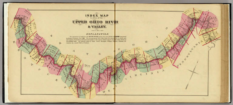
Hayes, Eli L.
Full Title
Index map to Atlas of the Upper Ohio River & Valley. (... compiled & drawn for the publishers by E.L. Hayes, assisted by E.F. Hayes, C.M. Beresford, assisted by S.A. Charpiot, F.L. Sanford, J.H. Sherman. Published by Titus, Simmons & Titus ... Phila. 1877. Eng. by Worley & Bracher ... Printed by H.J. Toudy & Co. ... Oldach & Mergenthaler Binders ...)
List No
4975.002
Note
Lithograph. Counties hand col. Includes "Explanation."
Author
Hayes, Eli L.
Full Title
Upper Ohio River and Valley part XVIII, 312 to 328 miles below Pittsburgh, 139 to 155 miles above Cincinnati. (with) South Point, Lawrence Co., Ohio. (with) Russell, Greenup Co., Ky. (with) Arigo City ... (with) Sandy City ... (with) Hampton City ... (all) Boyd Co., Ky. (with) Road between Arigo City & Catlettsburg, Ky. (... compiled & drawn for the publishers by E.L. Hayes, assisted by E.F. Hayes, C.M. Beresford, assisted by S.A. Charpiot, F.L. Sanford, J.H. Sherman. Published by Titus, Simmons & Titus ... Phila. 1877. Eng. by Worley & Bracher ... Printed by H.J. Toudy & Co. ... Oldach & Mergenthaler Binders ...)
List No
4975.112
Note
Hand col. lithograph with 6 insets. Shows buildings, landowners, townships, etc. Inset maps variously show buildings, lots, landowners, etc.
Author
Hayes, Eli L.
Full Title
Upper Ohio River and Valley part XIX, 329 to 346 miles below Pittsburgh, 121 to 138 miles above Cincinnati. (with) Hanging Rock, Lawrence Co., Ohio. (with) Greenupsburg ... Riverton ... (both) Greenup Co., Ky. (... compiled & drawn for the publishers by E.L. Hayes, assisted by E.F. Hayes, C.M. Beresford, assisted by S.A. Charpiot, F.L. Sanford, J.H. Sherman. Published by Titus, Simmons & Titus ... Phila. 1877. Eng. by Worley & Bracher ... Printed by H.J. Toudy & Co. ... Oldach & Mergenthaler Binders ...)
List No
4975.118
Note
Hand col. lithograph with 3 insets. Shows buildings, landowners, townships, etc. Inset maps variously show buildings, lots, landowners, etc; scales vary.
Author
Hayes, Eli L.
Full Title
Upper Ohio River and Valley part XX, 345 to 362 miles below Pittsburgh, 105 to 122 miles above Cincinnati. (with) Wheelersburg, Scioto Co., Ohio. (with) East Portsmouth, Scioto Co., O. (with) Springville, Greenup Co., Ky. (... compiled & drawn for the publishers by E.L. Hayes, assisted by E.F. Hayes, C.M. Beresford, assisted by S.A. Charpiot, F.L. Sanford, J.H. Sherman. Published by Titus, Simmons & Titus ... Phila. 1877. Eng. by Worley & Bracher ... Printed by H.J. Toudy & Co. ... Oldach & Mergenthaler Binders ...)
List No
4975.121
Note
Hand col. lithograph with 3 insets. Shows buildings, landowners, townships, etc. Inset maps variously show buildings, lots, landowners, etc; scales vary.
Author
Hayes, Eli L.
Full Title
Upper Ohio River and Valley part XXI, 362 to 381 miles below Pittsburgh, 86 to 105 miles above Cincinnati. (with) Buena Vista, Scioto Co., Ohio. (with) Rockville & Commercialtown ... (with) Rome, Stouts P.O. ... (both) Adams Co., O. (with) Quincy, Lewis Co., Ky. (... compiled & drawn for the publishers by E.L. Hayes, assisted by E.F. Hayes, C.M. Beresford, assisted by S.A. Charpiot, F.L. Sanford, J.H. Sherman. Published by Titus, Simmons & Titus ... Phila. 1877. Eng. by Worley & Bracher ... Printed by H.J. Toudy & Co. ... Oldach & Mergenthaler Binders ...)
List No
4975.124
Note
Hand col. lithograph with 4 insets. Shows buildings, landowners, townships, etc. Inset maps variously show buildings, lots, landowners, etc; scales vary.
Author
Hayes, Eli L.
Full Title
Upper Ohio River and Valley part XXII, 382 to 400 miles below Pittsburgh, 67 to 85 miles above Cincinnati. (with) Manchester, Adams Co., O. (with) Wrightsville, Adams Co., O. (... compiled & drawn for the publishers by E.L. Hayes, assisted by E.F. Hayes, C.M. Beresford, assisted by S.A. Charpiot, F.L. Sanford, J.H. Sherman. Published by Titus, Simmons & Titus ... Phila. 1877. Eng. by Worley & Bracher ... Printed by H.J. Toudy & Co. ... Oldach & Mergenthaler Binders ...)
List No
4975.126
Note
Hand col. lithograph with 2 insets. Shows buildings, landowners, townships, etc. Inset maps variously show buildings, lots, landowners, etc; scales (1:7,200) Manchester, (1:4.800) Wrightsville.
Author
Hayes, Eli L.
Full Title
Upper Ohio River and Valley part XXIII, 401 to 418 miles below Pittsburgh, 49 to 66 miles above Cincinnati. (with) Aberdeen ... (with) Levanna ... (both) Brown Co., O. (... compiled & drawn for the publishers by E.L. Hayes, assisted by E.F. Hayes, C.M. Beresford, assisted by S.A. Charpiot, F.L. Sanford, J.H. Sherman. Published by Titus, Simmons & Titus ... Phila. 1877. Eng. by Worley & Bracher ... Printed by H.J. Toudy & Co. ... Oldach & Mergenthaler Binders ...)
List No
4975.128
Note
Hand col. lithograph with 2 insets. Shows buildings, landowners, townships, etc. Inset maps variously show buildings, lots, landowners, etc; scales (1:7,200) Manchester, (1:4.800) Wrightsville.
Author
Hayes, Eli L.
Full Title
Upper Ohio River and Valley part XXIV, 418 to 434 miles below Pittsburgh, 33 to 49 miles above Cincinnati. (with) Chilo ... (with) Rural ... (with) Utopia ... (all) Clermont Co., O. (... compiled & drawn for the publishers by E.L. Hayes, assisted by E.F. Hayes, C.M. Beresford, assisted by S.A. Charpiot, F.L. Sanford, J.H. Sherman. Published by Titus, Simmons & Titus ... Phila. 1877. Eng. by Worley & Bracher ... Printed by H.J. Toudy & Co. ... Oldach & Mergenthaler Binders ...)
List No
4975.133
Note
Hand col. lithograph with 3 insets. Shows buildings, landowners, townships, etc. Inset maps variously show buildings, lots, landowners, etc; scales vary.
Author
Hayes, Eli L.
Full Title
Upper Ohio River and Valley part XXV, 435 to 451 miles below Pittsburgh, 16 to 32 miles above Cincinnati. (with) California ... (with) Johnsonville ... (with) East Columbia ... (all) Hamilton Co., Ohio. (with) California, Campbell Co., Ky. (... compiled & drawn for the publishers by E.L. Hayes, assisted by E.F. Hayes, C.M. Beresford, assisted by S.A. Charpiot, F.L. Sanford, J.H. Sherman. Published by Titus, Simmons & Titus ... Phila. 1877. Eng. by Worley & Bracher ... Printed by H.J. Toudy & Co. ... Oldach & Mergenthaler Binders ...)
List No
4975.138
Note
Hand col. lithograph with 4 insets. Shows buildings, landowners, townships, etc. Inset maps variously show buildings, lots, landowners, etc; scales (1:4,800)
Author
Hayes, Eli L.
Full Title
Upper Ohio River and Valley part XXVI, 452 to 467 miles below Pittsburgh, from Cincinnati to 15 miles above. (... compiled & drawn for the publishers by E.L. Hayes, assisted by E.F. Hayes, C.M. Beresford, assisted by S.A. Charpiot, F.L. Sanford, J.H. Sherman. Published by Titus, Simmons & Titus ... Phila. 1877. Eng. by Worley & Bracher ... Printed by H.J. Toudy & Co. ... Oldach & Mergenthaler Binders ...)
List No
4975.140
Note
Hand col. lithograph. Shows buildings, landowners, townships, wards, etc.
Author
Hayes, Eli L.
Full Title
Cincinnati, Ohio and vicinity. (... compiled & drawn for the publishers by E.L. Hayes, assisted by E.F. Hayes, C.M. Beresford, assisted by S.A. Charpiot, F.L. Sanford, J.H. Sherman. Published by Titus, Simmons & Titus ... Phila. 1877. Eng. by Worley & Bracher ... Printed by H.J. Toudy & Co. ... Oldach & Mergenthaler Binders ...)
List No
4975.141
Note
Col. lithographed map. Show wards, neighborhoods, etc.
Author
Rand McNally and Company
Full Title
Commercial Atlas of America. Rand McNally AutoTrails Map, District Number 2, Eastern Illinois, Southern Mich., Indiana, Western Ohio, Northern Ky.
List No
5028.083
Note
Shows roads and distances. Shows table of highway names, numbers, and markings.
Author
Letts, Son & Co.
Full Title
Eastern United States. No. 4. Letts's popular atlas. Letts, Son & Co. Limited, London. (1883)
List No
5371.121
Note
Colored map. The 10-sheet set shows cities, British consular offices, railroads, canals, roads, lights and lighthouses, relief by hachures, etc. This sheet covers Ohio and parts of Indiana, Kentucky, West Virginia, Pennsylvania and Virginia.
Author
W. & A.K. Johnston Limited
Full Title
Illinois, Indiana, Ohio, Kentucky.
List No
6921.124
Author
Taintor Brothers & Merrill
Full Title
Map of Ohio, Indiana, Illinois, and Kentucky.
List No
9731.014
1-34 of 34
|