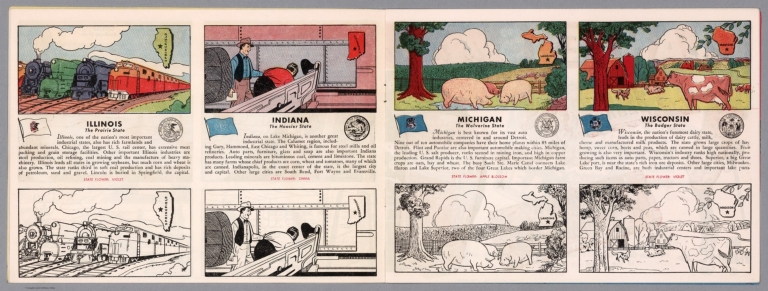
|
Author
[Fisher, Joseph R., Planters Peanuts (Firm)]
Full Title
Illinois : The prairie state -- Indiana : The hoosier state -- Michigan : The wolverine state -- Wisconsin : The badger state.
List No
14374.009
Note
Four views, representing Illinois, Indiana, Michigan and Wisconsin. Views show examples of the landscape and natural resources. Each view includes an inset map of the state, which marks the location of the capital city with a star. Accompanied by descriptive text, the state flags, seals and flowers: violet, zinnia, apple blossom and violet, respectively. The view of each state appears both in color (on top) and in black and white (bottom), the latter inviting coloration. Together, views are 18 x 52 cm, on two sheets 20 x 54 cm.
Author
Cram, George Franklin, 1841-1928
Full Title
Illinois. Geo. F. Cram, engraver and publisher, 262 and 264 Wabash Avenue, Chicago, Ill. 1882.
List No
14250.018
Note
Map of Illinois, showing railroads (both finished and unfinished), county boundaries, cities and towns, drainage and coastline. Political boundary lines in color. With index numbers along the perimeter, and decorative border. Also, with inset map: [Chicago and vicinity]. 55 x 40 cm, on sheet 58 x 45 cm.
Author
Andreas, A. T. (Alfred Theodore), 1839-1900
Full Title
Sectional Map of Illinois ... 1872.
List No
0015.004
Note
Includes population statistics.
Author
Appleton, D. & Co.
Full Title
Map of Illinois. Copyright 1891 by Matthews-Northrup Co. ... Buffalo, New York. (inset) City of Chicago. (to accompany) The Library Atlas Of Modern Geography ... New York, D. Appleton And Company 1892. (on upper margin) Illinois, 61.
List No
0026.160
Note
Color map. Shows county boundaries and county seat, capital, railways, roads, etc. "Size of type indicates importance of the places". Includes notes. Relief shown by hachures. Prime meridians are Greenwich and Washington.
Author
Appleton, D. & Co.
Full Title
Map of Chicago, Illinois. Copyright 1891 by Matthews-Northrup Co. ... Buffalo, New York. (to accompany) The Library Atlas Of Modern Geography ... New York, D. Appleton And Company 1892. (on upper margin) Chicago. 62.
List No
0026.163
Note
Color plan of Chicago. Shows railways, street car lines, parks, etc. Includes numerical references to Depots, hotels, churches, major buildings, points of interest, parks and cemeteries.
Author
Arbuckle Bros.
Full Title
Maryland, Georgia, Illinois, Pennsylvania. Copyright 1889 Arbuckle Bros. N.Y.
List No
0027.006
Note
Sheet with maps of four states in full color. On the card for Illinois, it is noted that the inhabitants of Chicago are "probably the most energetic people in the world." Pennsylvania is noted for being second only to New York in manufacturing. Each card measures 7.5 x 12.5 cm.
Author
Asher & Adams
Full Title
Asher & Adams' Illinois. Entered according to Act of Congress in the year 1874 by Asher & Adams ... at Washington. (New York, 1874)
List No
0041.021
Note
Hand col. engraved map. Shows townships, distances along railroads, etc. Prime meridians: Greenwich and Washington.
Author
[Bartholomew, John, Black, Adam & Charles]
Full Title
Ohio, Indiana & Illinois. Published by A. & C. Black. Edinburgh. Printed in Colours by Schenck & Macfariane. Edinburgh. Drawn & Engraved by J. Bartholomew, Edinburgh.
List No
0073.008
Note
States outlined in color. Land tinted.
Author
Bradford, Thomas G.
Full Title
Illinois. Entered ... 1838, by T.G. Bradford ... Massachusetts. Engraved by G.W. Boynton.
List No
0089.020
Note
In full color.
Full Title
Carte geographique, statistique et historique de l'Illinois. Illinois. Grave par (Auguste Francois?) Ales, Rue des Noyers, No. 50, a Paris. Fonderie et Imprimerie de J. Carez. (1825)
List No
0102.033
Note
Hand colored engraved map. Text and tables at sides and bottom. Shows counties, Public Land Survey System townships, settlements, rivers, etc. Prime meridians: Washington and Paris.
Author
Burr, David H., 1803-1875
Full Title
Map of Illinois & Missouri Exhibiting the Post Offices, Post Roads, Canals, Rail Roads, &c. By David H. Burr. (Late Topographer to the Post Office.) Geographer to the House of Representatives of the U.S. John Arrowsmith. Entered ... July 10th, 1839, by David H. Burr ... District of Columbia.
List No
0104.012
Note
In full color by county. Postal routes by coach, stage, sulkey, cross, rail roads and canals shown. In 8 sections mounted on linen. Label on back states "No. 12. Illinois, Missouri."
Author
[Carey, H. C., Lea, I.]
Full Title
Geographical, Historical, And Statistical Map Of Illinois. Illinois. No. 33. J. Yeager Sculp.
List No
0122.028
Note
In full color by county or region surrounded by text.
Author
Colton, G.W.
Full Title
Illinois. (with) Vicinity Of Chicago. Published By J.H. Colton & Co. No. 172 William St. New York. Entered ... 1855 by J.H. Colton & Co. ... New York. No. 44.
List No
0149.049
Note
In full color by county.
Author
Colton, G.W.
Full Title
The City Of St. Louis Missouri. (with) The City Of Chicago Illinois. Published By J.H. Colton & Co. No. 172 William St. New York. Entered ... 1855 by J.H. Colton & Co. ... New York. No. 45.
List No
0149.050
Note
In full color by area. Numerous buildings are shown and labeled. Both maps inside decorative border.
Author
Colton, G.W.
Full Title
Colton's Illinois. (inset) Vicinity of Chicago. Published By J. H. Colton. No. 172 William St. New York.
List No
0151.055
Note
Prime meridians are Greenwich and Washington D.C. Map showing the political boundaries in color.
Author
Colton, G.W.
Full Title
The City of St. Louis, Missouri. The City of Chicago, Illinois. Published By J. H. Colton. No. 172 William St. New York.
List No
0151.057
Note
The plans of Chicago & St. Louis are upon the same scale.
Author
Colton, G.W.
Full Title
Colton's Illinois. (inset) Plan of Cook county & Vicinity of Chicago. Published By G. W & C. B. Colton & Co. No. 172 William St. New York.
List No
0152.054
Author
Colton, G.W.
Full Title
The City of St. Louis, Missouri. The City of Chicago, Illinois. Published By G. W & C. B. Colton & Co. No. 172 William St. New York.
List No
0152.055
Note
The plans of Chicago & St. Louis are upon the same scale.
Author
Cram, George Franklin
Full Title
Illinois.
List No
0210.042
Note
Prime meridians Greenwich and Washington.
Author
Finley, Anthony
Full Title
Map of the States Of Ohio Indiana & Illinois And Part Of Michigan Territory Compiled from the Latest Authorities. D.H. Vance Del. J.H. Young Sc. Philada. Published by A. Finley 1825.
List No
0278.011
Note
In full color by county or region of the state. Statistical information includes mileage, population broken down by White Males, White Females, Free People of Colour, Slaves and Militia.
Author
Finley, Anthony
Full Title
Map of the States of Ohio, Indiana & Illinois and Part of the Michigan Territory, Complied from the Latest Athorities.
List No
0279.015
Author
Finley, Anthony
Full Title
Map of the States of Ohio, Indiana, & Illinois, and Part of the Michigan Territory, Compiled from the Latest Authorities. D.H. Vance Del., Philada. Published by A. Finley 1827. J.H. Young Sc.
List No
0280.011
Note
Relief shown by hachures. Prime meridian Washington. Statistical table for each state.
Author
Finley, Anthony
Full Title
Illinois. Young & Delleker Sc. Published by A. Finley, Philada. (to accompany) A New General Atlas Comprising a Complete Set of Maps, representing the Grand Divisions Of The Globe ... Philadelphia: Published by Anthony Finley. 1827.
List No
0282.031
Note
Full color map on sheet 35x27. Relief shown pictorially. Prime meridians are Washington and Greenwich. Shows counties, major cities, roads and rivers.
Author
Finley, Anthony
Full Title
Illinois. Published by A. Finley Philada. Young & Delleker Sc.
List No
0285.027
Note
Full color by county.
Author
Gray, O.W.
Full Title
Gray's Atlas Map of Illinois. (inset) Plan of Cook County & Vicinity of Chicago.
List No
0310.061
Author
[Gray, Frank A., Gray, O.W.]
Full Title
Illinois. Entered ... 1867 by G.W. & C.B. Colton & Co. (inset) Plan of Cook County & Vicinity of Chicago.
List No
0312.044
Author
Johnson, A.J.
Full Title
Johnson's Illinois Published By Johnson and Ward. Entered ... 1864, by A.J. Johnson ... New York.
List No
0352.037
Note
Full color by county, with heavy outlines around the state. Shows railroads, and roads. Prime meridians are Greenwich and Washington D.C.
Author
Johnson, A.J.
Full Title
Johnson's Illinois. Entered ... 1864.
List No
0358.042
Author
Johnson, A.J.
Full Title
Johnson's Illinois Published By Johnson and Ward.
List No
0535.035
Note
In full color by county. Relief shown by hachures. Meridians Greenwich and Washington D.C.
Author
Mitchell, Samuel Augustus
Full Title
A New Map Of Illinois With Its Proposed Canals Roads And Distances from place to place along the Stage & Steam Boat Routes (with) Lead Region. Published By S. Augustus Mitchell, N.E. corner of Market & 7th Street Philada., 1846. Entered ... 1846 by H.N. Burroughs ... Pennsylvania.
List No
0537.032
Note
In full color by county with steamboat route distances included.
Author
Mitchell, Samuel Augustus
Full Title
A New Map of Illinois with its Proposed Canals, Roads & Distances from Place to Place along the Stage & Steam Boat Routes. Published By S. Augustus Mitchell. N.E. corner of Market & 7th. Streets. Philadelphia. (inset map) Lead Region.
List No
0545.035
Note
Full color map. Includes explanation chart, and reference to steam boat routes. Prime meridian is Washington D.C.
Author
Mitchell, Samuel Augustus Jr.
Full Title
County map of the State of Illinois. (inset) 39. Plan of Chicago. Entered ... 1861 by S. Augustus Mitchell, Jr. ... Pennsylvania.
List No
0572.033
Note
Full color map by county. Prime meridians are Greenwich and Washington, D.C.
Author
Mitchell, Samuel Augustus Jr.
Full Title
County map of the State of Illinois. (inset map) 44. Plan of Chicago. Entered ... 1867 by S. Augustus Mitchell, Jr. ... Pennsylvania.
List No
0579.034
Note
Color map by county. Prime meridians are Greenwich and Washington, D.C.
Author
Mitchell, Samuel Augustus Jr.
Full Title
Chicago. Entered ... 1867 by S. Augustus Mitchell, Jr. ... Pennsylvania.
List No
0579.035
Note
Color map. Showing roads, railroads, etc.
Author
Mitchell, Samuel Augustus
Full Title
County & township map of the state of Illinois. (with) Vicinity of Springfield. Entered ... 1879 by S. Augustus Mitchell ... Washington. (1880)
List No
0586.032
Note
Hand colored map with inset. Shows settlements, railroads, etc. Prime meridians: Greenwich and Washington.
Full Title
Chicago. (By S. Augustus Mitchell. 1880)
List No
0586.033
Note
Hand colored. Shows wards, railroads, etc. Includes index "Chicago city street guide." Ornamental border is 8 mm wide.
Author
Mitchell, Samuel Augustus Jr.
Full Title
County & township map of the state of Illinois. (with) Chicago and vicinity. Copyright by S. Augustus Mitchell 1884.
List No
0592.035
Note
Hand colored map with inset. Shows settlements, railroads, rivers, etc. Prime meridians: Greenwich and Washington.
Author
Mitchell, Samuel Augustus Jr.
Full Title
Chicago. Copyright by S. Augustus Mitchell 1885.
List No
0592.036
Note
Hand colored. Shows wards, railroads, etc.
Full Title
County & township map of the state of Illinois. (with) Chicago and vicinity. Copyright 1887 by Wm. M. Bradley & Bro. (1890)
List No
0594.034
Note
Hand colored map with inset. Shows settlements, railroads, rivers, etc. Prime meridians: Greenwich and Washington.
Full Title
Chicago. Copyright 1887 by Wm. M. Bradley & Bro. (1890)
List No
0594.035
Note
Hand colored. Shows wards, railroads, etc.
Author
[Morse, Charles W., Colby, Charles A.]
Full Title
Illinois.
List No
0623.037
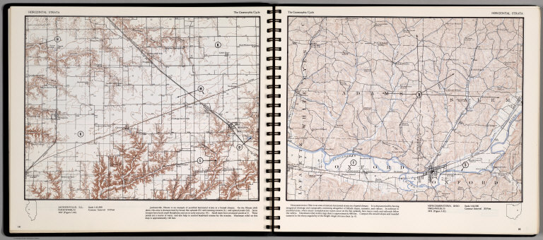
Author
[Scovel, James L., O'Brien, Emmett J]
Full Title
Horizontal Strata. Jacksonville, Ill. (on the opposite page) Newcomerstown, Ohio. (on top of the page) Geomorphic Cycle.
List No
0889.011
Note
Two contour maps, includes text, and outline location map. Relief shown by contours and spot height.
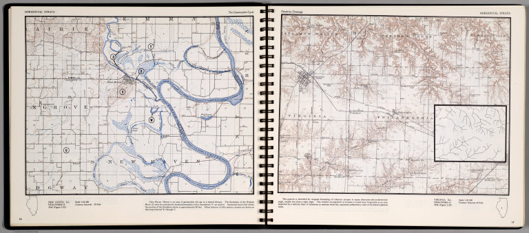
Author
[Scovel, James L., O'Brien, Emmett J]
Full Title
Horizontal Strata. New Haven, Ill. (on top of the page) The Geomorphic Cycle. (on opposite page) Virginia, Ill. (on top of the page) Dendritic Drainage. (untitled inset) Treelike arrangement of streams.
List No
0889.012
Note
Contour map, includes text, and outline location map. Relief shown by contours and spot height.
Author
Society for the Diffusion of Useful Knowledge (Great Britain)
Full Title
North America sheet V. The North West and Michigan territories. J. & C. Walker sculpt. Published by Baldwin & Cradock under the superintendence of the Society for the Diffusion of Useful Knowledge, April 1st. 1833. Printed by Russell, Penge. (London: Chapman & Hall, 1844)
List No
0890.132
Note
Engraved map. Relief shown by hachures. County boundaries hand col. Source: Tanner.
Author
Society for the Diffusion of Useful Knowledge (Great Britain)
Full Title
North America sheet IX. Parts of Missouri, Illinois and Indiana. Published under the superintendence of the Society for the Diffusion of Useful Knowledge. Engraved by J. & C. Walker. Published July 1st. 1833 by Baldwin & Cradock, 47 Paternoster Row, London. Printed by Russell, Penge. (London: Chapman & Hall, 1844)
List No
0890.136
Note
Engraved map. Relief shown by hachures. County boundaries hand col. Source: Tanner.
Author
Tanner, Henry S.
Full Title
A New Map of Illinois with Its Roads & Distances from place to place along the Stage & Steam Boat Routes by H.S. Tanner. (inset) Lead Region.
List No
0976.033
Author
Tanner, Henry S.
Full Title
A New Map Of Illinois With Its Proposed Canals, Roads & Distances from place to place, along the Stage & Steam Boat Routes. by H.S. Tanner. (with) Lead Region. Engraved by J. & W.W. Warr. Entered ... 1833 by H.S. Tanner ... Pennsylvania. Philadelphia, Published by H.S. Tanner. (above neat line) Tanner's Universal Atlas.
List No
0977.028
Note
Counties in full color with steamboat route distances shown. The Lead Region inset map includes smelting furnaces, mineral or lead ore, copper mines, and farms.
Author
Tanner, Henry S.
Full Title
A New Map of Illinois with Its Roads & Distances from place to place along the Stage & Steam Boat Routes by H.S. Tanner. (inset) Lead Region.
List No
0980.034
Author
U.S. General Land Office
Full Title
Map of the State of Illinois. Department of Interior, General Land Office, October 2d 1866. Jo. S. Wilson, Commissioner. Bowen & Co. lith. Phila.
List No
1070.003
Note
Map in outline color. Lead and copper regions are highlighted. It is noted that in one year more than 13,000,000 pounds of lead had been smelted.
Author
[Whitney-Graham Company, Inc., Green, W.H., Public Service Co. of Northern Illinois]
Full Title
Cities, towns and communities served by Public Service Company of Northern Illinois. April 1926. W.H Geen. 4-26. (to accompany) The blue book of map making : America's map makers. R.W.C. The Whitney-Graham Co. Inc.
List No
11489.005
Note
Pictorial birds-eye-view colored map, illustrated by W,H. Green. Shows major cities and towns, electric transmission lines, distribution lines, electric stations and substations. Gas pumping stations and gas mains. Includes list of the cities and towns, and legend.
|