|
Author
[United States. Naval Oceanographic Office, United States. Department of the Navy. Bureau of Navigation, Witzel, H. M. (Horace Mark), 1858-1927, Hayden, Edward Everett, 1858-1932, Picking, Henry F. (Henry Forry), 1840-1899]
Full Title
Pilot chart of the North Atlantic Ocean : January, 1890. Date of publication, December 30, 1890. Division of Marine Meteorology, H. M. Witzel, Lieut. U.S.N. Marine Meteorologist, Everett Hayden. Published monthly at Hydrographic Office, Navy Department, Washington, D.C. Henry F. Picking, Captain, U.S.N. Hydrographer.
List No
14389.003
Note
Nautical chart of the North Atlantic Ocean representing January, 1890. Shows cities, coastlines, shoals, depths, islands, sailing routes, ocean currents, storm tracks, weather forecasts, fog belts, equatorial rains, wind force and directions, as well as ice fields, icebergs and the limits of ice coverage. Includes latitudinal and longitudinal lines, a legend and compass rose with north oriented toward top of sheet. Descriptive text throughout, such as reports on weather, barometric pressure, dangerous obstructions to navigation along the coast, tidal rivers, hurricanes and other storms. Insets: North Atlantic storms : June and October, lat. 23° to 55° ... -- June and October, lat. 20° to 23° -- June and October, lat. 10° to 20° -- Storm signals, Atlantic and Gulf Coast of the United States. Colored lithograph, with infographics overlaid upon geography. Chart is 54 x 80 cm, on double sheet 61 x 86 cm. "The variation is for 1888."
Author
[United States. Naval Oceanographic Office, United States. Department of the Navy. Bureau of Navigation, Witzel, H. M. (Horace Mark), 1858-1927, Hayden, Edward Everett, 1858-1932, Picking, Henry F. (Henry Forry), 1840-1899]
Full Title
Pilot chart of the North Atlantic Ocean : February, 1890. Date of publication, January 31, 1890. Division of Marine Meteorology, H. M. Witzel, Lieut. U.S.N. Marine Meteorologist, Everett Hayden. Published monthly at Hydrographic Office, Navy Department, Washington, D.C. Henry F. Picking, Captain, U.S.N. Hydrographer.
List No
14389.004
Note
Nautical chart of the North Atlantic Ocean representing February, 1890. Shows cities, coastlines, shoals, depths, islands, sailing routes, ocean currents, storm tracks, weather forecasts, fog belts, equatorial rains, wind force and directions, as well as ice fields, icebergs and the limits of ice coverage. Includes latitudinal and longitudinal lines, a legend and compass rose with north oriented toward top of sheet. Descriptive text throughout, such as reports on weather, barometric pressure, storms, an electric phenomenon, the derelict American schooner "Jacob M. Haskell", and signals for information, storms and nighttime. Insets: North Atlantic storms : June and October, lat. 23° to 55° ... -- June and October, lat. 20° to 23° -- June and October, lat. 10° to 20° -- Storm signals, Atlantic and Gulf Coast of the United States. Colored lithograph, with infographics overlaid upon geography. Chart is 54 x 80 cm, on double sheet 61 x 86 cm. "The variation is for 1889."
Author
[United States. Naval Oceanographic Office, United States. Department of the Navy. Bureau of Navigation, Witzel, H. M. (Horace Mark), 1858-1927, Hayden, Edward Everett, 1858-1932, Picking, Henry F. (Henry Forry), 1840-1899]
Full Title
Pilot chart of the North Atlantic Ocean : March, 1890. Date of publication, February 28, 1890. Division of Marine Meteorology, H. M. Witzel, Lieut. U.S.N. Marine Meteorologist, Everett Hayden. Published monthly at Hydrographic Office, Navy Department, Washington, D.C. Henry F. Picking, Captain, U.S.N. Hydrographer.
List No
14389.005
Note
Nautical chart of the North Atlantic Ocean representing March, 1890. Shows cities, coastlines, shoals, depths, islands, sailing routes, ocean currents, storm tracks, weather forecasts, fog belts, equatorial rains, wind force and directions, as well as ice fields, icebergs and the limits of ice coverage. Includes latitudinal and longitudinal lines, a legend and compass rose with north oriented toward top of sheet. Descriptive text throughout, such as reports on weather, barometric pressure, icebergs, dangerous obstructions to navigation along the coast, surface and sub-surface temperatures, and signals for information, storms and nighttime. Insets: Sea-Water temperature -- North Atlantic storms : June and October, lat. 23° to 55° ... -- June and October, lat. 20° to 23° -- June and October, lat. 10° to 20° -- Storm signals, Atlantic and Gulf Coast of the United States. Colored lithograph, with infographics overlaid upon geography. Chart is 54 x 80 cm, on double sheet 61 x 86 cm. "The variation is for 1889."
Author
[United States. Naval Oceanographic Office, United States. Department of the Navy. Bureau of Navigation, Witzel, H. M. (Horace Mark), 1858-1927, Hayden, Edward Everett, 1858-1932, Picking, Henry F. (Henry Forry), 1840-1899]
Full Title
Pilot chart of the North Atlantic Ocean : April, 1890. Date of publication, March 31, 1890. Division of Marine Meteorology, H. M. Witzel, Lieut. U.S.N. Marine Meteorologist, Everett Hayden. Published monthly at Hydrographic Office, Navy Department, Washington, D.C. Henry F. Picking, Captain, U.S.N. Hydrographer.
List No
14389.006
Note
Nautical chart of the North Atlantic Ocean representing April, 1890. Shows cities, coastlines, shoals, depths, islands, sailing routes, ocean currents, storm tracks, weather forecasts, fog belts, equatorial rains, wind force and directions, as well as ice fields, icebergs and the limits of ice coverage. Includes latitudinal and longitudinal lines, a legend and compass rose with north oriented toward top of sheet. Descriptive text throughout, such as reports on weather, barometric pressure, icebergs, dangerous obstructions to navigation along the coast, the use of oil on seas, and signals for information, storms and nighttime. Insets: North Atlantic storms : June and October, lat. 23° to 55° ... -- June and October, lat. 20° to 23° -- June and October, lat. 10° to 20° -- Storm signals, Atlantic and Gulf Coast of the United States. Colored lithograph, with infographics overlaid upon geography. Chart is 54 x 80 cm, on double sheet 61 x 86 cm. "The variation is for 1889."
Author
[United States. Naval Oceanographic Office, United States. Department of the Navy. Bureau of Navigation, Witzel, H. M. (Horace Mark), 1858-1927, Hayden, Edward Everett, 1858-1932, Picking, Henry F. (Henry Forry), 1840-1899]
Full Title
Pilot chart of the North Atlantic Ocean : May, 1890. Date of publication, April 30, 1890. Division of Marine Meteorology, H. M. Witzel, Lieut. U.S.N. Marine Meteorologist, Everett Hayden. Published monthly at Hydrographic Office, Navy Department, Washington, D.C. Henry F. Picking, Captain, U.S.N. Hydrographer.
List No
14389.007
Note
Nautical chart of the North Atlantic Ocean representing May, 1890. Shows cities, coastlines, shoals, depths, islands, sailing routes, ocean currents, storm tracks, weather forecasts, fog belts, equatorial rains, wind force and directions, as well as ice fields, icebergs and the limits of ice coverage. Includes latitudinal and longitudinal lines, a legend and compass rose with north oriented toward top of sheet. Descriptive text throughout, such as reports on weather, barometric pressure, ice, dangerous obstructions to navigation along the coast, the use of oil on seas, and signals for information, storms and nighttime. Insets: North Atlantic storms : June and October, lat. 23° to 55° ... -- June and October, lat. 20° to 23° -- June and October, lat. 10° to 20° -- Storm signals, Atlantic and Gulf Coast of the United States. Colored lithograph, with infographics overlaid upon geography. Chart is 54 x 80 cm, on double sheet 61 x 86 cm. "The variation is for 1888."
Author
[United States. Naval Oceanographic Office, United States. Department of the Navy. Bureau of Navigation, Witzel, H. M. (Horace Mark), 1858-1927, Hayden, Edward Everett, 1858-1932, Picking, Henry F. (Henry Forry), 1840-1899]
Full Title
Pilot chart of the North Atlantic Ocean : June, 1890. Date of publication, May 29. Division of Marine Meteorology, H. M. Witzel, Lieut. U.S.N. Marine Meteorologist, Everett Hayden. Published monthly at Hydrographic Office, Navy Department, Washington, D.C. Henry F. Picking, Captain, U.S.N. Hydrographer.
List No
14389.008
Note
Nautical chart of the North Atlantic Ocean representing June, 1890. Shows cities, coastlines, shoals, depths, islands, sailing routes, ocean currents, storm tracks, weather forecasts, fog belts, equatorial rains, wind force and directions, as well as ice fields, icebergs and the limits of ice coverage. Includes latitudinal and longitudinal lines, a legend and compass rose with north oriented toward top of sheet. Descriptive text throughout, such as reports on weather, barometric pressure, collisions with icebergs, dangerous obstructions to navigation along the coast, and signals for information, storms and nighttime. Insets: The Hurricane of November 25, 1888 : Noon, G.M.T. -- North Atlantic storms : June and October, lat. 23° to 55° ... -- June and October, lat. 20° to 23° -- June and October, lat. 10° to 20° -- Storm signals, Atlantic and Gulf Coast of the United States. Colored lithograph, with infographics overlaid upon geography. Chart is 54 x 80 cm, on double sheet 61 x 86 cm. "The variation is for 1888."
Author
[United States. Naval Oceanographic Office, United States. Department of the Navy. Bureau of Navigation, Witzel, H. M. (Horace Mark), 1858-1927, Hayden, Edward Everett, 1858-1932, Picking, Henry F. (Henry Forry), 1840-1899]
Full Title
Pilot chart of the North Atlantic Ocean : July, 1890. Date of publication, June 30. Division of Marine Meteorology, H. M. Witzel, Lieut. U.S.N. Marine Meteorologist, Everett Hayden. Published monthly at Hydrographic Office, Navy Department, Washington, D.C. Henry F. Picking, Captain, U.S.N. Hydrographer.
List No
14389.009
Note
Nautical chart of the North Atlantic Ocean representing July, 1890. Shows cities, coastlines, shoals, depths, islands, sailing routes, ocean currents, storm tracks, weather forecasts, fog belts, equatorial rains, wind force and directions, as well as ice fields, icebergs and the limits of ice coverage. Includes latitudinal and longitudinal lines, a legend and compass rose with north oriented toward top of sheet. Descriptive text throughout, such as reports on weather, barometric pressure, hurricanes, derelicts towed in and wrecks destroyed, dangerous obstructions to navigation along the coast, ice, monsoons, and signals for information, storms and nighttime. Insets: Hurricanes in the North Atlantic : Typical circulation of the wind, from actual observation -- North Atlantic storms : June and October, lat. 23° to 55° ... -- June and October, lat. 20° to 23° -- June and October, lat. 10° to 20° -- Storm signals, Atlantic and Gulf Coast of the United States. Colored lithograph, with infographics overlaid upon geography. Chart is 54 x 80 cm, on double sheet 61 x 86 cm. "The variation is for 1888."
Author
[United States. Naval Oceanographic Office, United States. Department of the Navy. Bureau of Navigation, Witzel, H. M. (Horace Mark), 1858-1927, Hayden, Edward Everett, 1858-1932, Picking, Henry F. (Henry Forry), 1840-1899]
Full Title
Pilot chart of the North Atlantic Ocean : August, 1890. Date of publication, July 31. Division of Marine Meteorology, H. M. Witzel, Lieut. U.S.N. Marine Meteorologist, Everett Hayden. Published monthly at Hydrographic Office, Navy Department, Washington, D.C. Henry F. Picking, Captain, U.S.N. Hydrographer.
List No
14389.010
Note
Nautical chart of the North Atlantic Ocean representing August, 1890. Shows cities, coastlines, shoals, depths, islands, sailing routes, ocean currents, storm tracks, weather forecasts, fog belts, equatorial rains, wind force and directions, as well as ice fields, icebergs and the limits of ice coverage. Includes latitudinal and longitudinal lines, a legend and compass rose with north oriented toward top of sheet. Descriptive text throughout, such as reports on weather, barometric pressure, hurricanes, dangerous obstructions to navigation along the coast, and signals for information, storms and nighttime. Insets: The great hurricane of August, 1887 : Aug. 21, 1887 -- Aug. 22, 1887 -- Aug. 23, 1887 -- North Atlantic storms : June and October, lat. 23° to 55° ... -- June and October, lat. 20° to 23° -- June and October, lat. 10° to 20° -- Storm signals, Atlantic and Gulf Coast of the United States. Colored lithograph, with infographics overlaid upon geography. Chart is 54 x 80 cm, on double sheet 61 x 86 cm. "The variation is for 1888."
Author
[Geological Survey (U.S.), Goetzmann, William H.]
Full Title
Exploration and settlement : 1850-1890 / compiled from information provided by William H. Goetzmann, Univertsity of Texas, 1966.
List No
14359.102
Note
Historical map representing the United States, featuring voyages of exploration and settlement from 1850 to 1890. Maps show the routes of explorers, settlements (including both colonial and indigenous), forts, railways, roads, trails, canals, mines, the extent of colonized area, topography, bodies of water, coastlines and islands. Relief shown with shading. Includes legends, as well as a bar scale and scale statement. With inset map: Alaska. Colored lithograph. Map is 20 x 30 cm, on sheet 49 x 35 cm. Accompanied by descriptive text, with references. Appears in Special subject maps section, subsection History.
Author
[Suomen Maantieteellinen Seura, Tilgmann, Ferdinand, 1832-1911]
Full Title
No. 5. Isotermit : Eri kuukausina ja koko vuonna. 1881-1890. = Isotermer : För månaderna och året. 1881-1890. : Vuosi. = Året -- Tammikuu. = Januari. -- Helmikuu. = Februari. -- Maaliskuu. = Mars. -- Huhtikuu. = April. -- Toukokuu. = Maj. -- Kesäkuu. = Juni. -- Heinäkuu. = Juli. -- Elokuu. = Augusti. -- Syyskuu. = September. -- Lokakuu. = Oktober. -- Marraskuu. = November. -- Joulukuu. = December.
List No
14366.014
Note
Thirteen climate maps of Finland. Maps feature isotherms - lines of the same average temperature over time - in different months and throughout the year, from 1881 to 1890. Maps also show cities, railways, bodies of water, drainage, coastlines and islands. Maps include latitudinal and longitudinal lines. Colored lithograph. Together, maps are 51 x 38 cm, on double sheet 60 x 43 cm. Text presented in parallel Finnish and Swedish.
Author
[France. Ministère des travaux publics. Administration des routes, France. Direction des cartes, plans et archives et de la statistique graphique]
Full Title
Rio de Janeiro. 1ère Série. Pl. V. Direction des Cartes et Plans du Ministère des Travaux Publics. 1884. Aut. J. Marchadier et Cie. Rue de Lafayette, 150 Paris.
List No
14306.011
Note
Map showing the port of Rio de Janeiro, Brazil, in 1884. Features streets, bridges, drainage, islands, docks and soundings, with depths given in meters. Includes a bar scale and compass rose, with north oriented toward top of sheet. Descriptive text throughout. Lithograph in black, white and green. With two inset maps: Coupe en travers : du Quai projeté -- Coupe AB : Profil en travers du Brise-lames projeté. Together, maps are 29 x 23 cm, on sheet 33 x 25 cm. Appears in Première livraison.
Author
[France. Ministère des travaux publics. Administration des routes, France. Direction des cartes, plans et archives et de la statistique graphique]
Full Title
Trieste. 1ère Série. Pl. XI. Direction des Cartes et Plans du Ministère des Travaux Publics. 1883. Gravé et imprimé chez Becquet Fres et Simon. Paris.
List No
14306.017
Note
Map showing the port of Trieste, Italy, in 1883. Features streets, bridges, drainage and docks. Includes a bar scale and compass rose, with north oriented toward left of sheet. Descriptive text throughout. Lithograph in black, white and green. With two inset maps: Coupe en travers d'un Môle avec quai maçonné -- Coupe en travers de la jetée. Map is 23 x 48 cm, on fold-out sheet 33 x 50 cm. Bookplate title pasted to verso: Pl. XI. 1re série. Trieste. Appears in Première livraison.
Author
[France. Ministère des travaux publics. Administration des routes, France. Direction des cartes, plans et archives et de la statistique graphique]
Full Title
Stockholm et Lilla-Värtan. 1ère Série. Pl. XX. Direction des Cartes et Plans du Ministère des Travaux Publics. 1883. Gravé et Imprimé chez Becquet Fres. et Simon. Rue des Noyers, 37. Paris.
List No
14306.026
Note
Map showing the port of Stockholm and the strait of Lilla-Värtan, Sweden, in 1883. Features streets, bridges, drainage, islands and docks. Includes a bar scale and compass rose, with north oriented toward top of sheet. Descriptive text throughout. Lithograph in black, white and green. With inset map: Plan de détail (Port de Lilla-Värtan). Map is 27 x 46 cm, on sheet 33 x 50 cm. Bookplate title pasted to verso: Pl. XX. 1re série. Stockholm. Appears in Première livraison.
Author
[France. Ministère des travaux publics. Administration des routes, France. Direction des cartes, plans et archives et de la statistique graphique, École nationale des ponts et chaussées (France)]
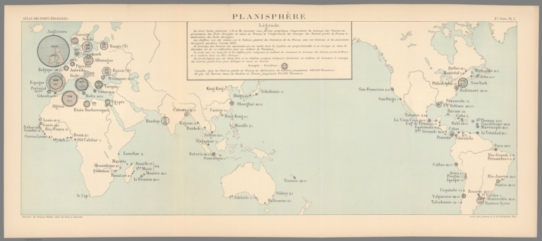
Full Title
Planisphère. 2e Série. Pl. I. Ministère des Travaux Publics. Ecole des Ponts et Chaussées. Gravé par A. Simon, 13, R. du Val-de-Grâce. Paris.
List No
14306.036
Note
Map showing the ports of the world, in 1886 comparing the magnitude of imports to France from around the globe. Features seas, lakes, drainage, coastlines and islands. Includes a legend and data visualization. Lithograph in black, white and blue. Map is 28 x 70 cm, on fold-out sheet 33 x 75 cm. Bookplate title pasted to verso: Pl. I. Planisphère. Appears in Deuxième livraison.
Author
[France. Ministère des travaux publics. Administration des routes, France. Direction des cartes, plans et archives et de la statistique graphique, École nationale des ponts et chaussées (France)]
Full Title
Europe. 2e Série. Pl. II. Ministère des Travaux Publics. Ecole des Ponts et Chaussées. Gravé par A. Simon, 13, R. du Val-de-Grâce. Paris.
List No
14306.037
Note
Map showing the ports of Europe, in 1886, comparing the magnitude of imports to France from around the continent. Features seas, lakes, drainage, coastlines and islands. Includes data visualization. Lithograph in black, white and blue. Map is 32 x 46 cm, on sheet 33 x 50 cm. Bookplate title pasted to verso: Pl. II. Europe. Appears in Deuxième livraison.
Author
[France. Ministère des travaux publics. Administration des routes, France. Direction des cartes, plans et archives et de la statistique graphique, École nationale des ponts et chaussées (France)]
Full Title
Iles Britanniques. 2e Série. Pl. III. Ministère des Travaux Publics. Ecole des Ponts et Chaussées. Lith. A. Simon, 13, R. du Val-de-Grâce. Paris.
List No
14306.038
Note
Map showing the ports of the British Isles, in 1886, comparing the magnitude of imports to France from around the Isles. Features lakes, drainage, coastlines and islands. Includes data visualization. Lithograph in black, white and blue. Map is 27 x 22 cm, on sheet 33 x 25 cm. Appears in Deuxième livraison.
Author
[France. Ministère des travaux publics. Administration des routes, France. Direction des cartes, plans et archives et de la statistique graphique, École nationale des ponts et chaussées (France)]
Full Title
Carthagène. 3e Série. Pl. IX. Ministère des Travaux Publics. Ecole des Ponts et Chaussées. Lith. A. Simon, 13, R. du Val-de-Grâce. Paris.
List No
14306.071
Note
Map showing the port of Cartagena, Spain, in 1887. Features topography, railways, streets, bridges, canals, drainage, docks and soundings, with depths given in meters. Relief shown with hachures. Includes a bar scale and compass rose, with north oriented toward top-right of sheet. Descriptive text throughout. Lithograph in black, white and green. Map is 27 x 21 cm, on sheet 33 x 25 cm. Appears in Troisième livraison.
Author
[France. Ministère des travaux publics. Administration des routes, France. Direction des cartes, plans et archives et de la statistique graphique, École nationale des ponts et chaussées (France)]
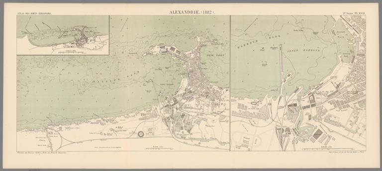
Full Title
Alexandrie. (1882). 3e Série. Pl. XVII. Ministère des Travaux Publics. Ecole des Ponts et Chaussées. Lith. A. Simon, 13, R. du Val-de-Grâce. Paris.
List No
14306.079
Note
Map showing the port of Alexandria, Egypt, in 1882. Features railways, streets, bridges, drainage, docks and soundings, with depths given in meters. Includes a bar scale and compass rose, with north oriented toward top-right of sheet. Descriptive text throughout. Lithograph in black, white and green. With inset map: [New Port]. Together, maps are 28 x 70 cm, on fold-out sheet 33 x 75 cm. Bookplate title pasted to verso: Pl. XVII. Alexandrie. Appears in Troisième livraison.
Author
[France. Ministère des travaux publics. Administration des routes, France. Direction des cartes, plans et archives et de la statistique graphique, École nationale des ponts et chaussées (France)]
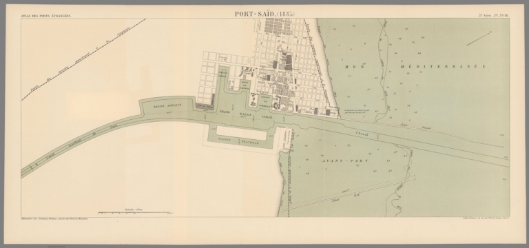
Full Title
Port-Saïd. (1885). 3e Série. Pl. XVIII. Ministère des Travaux Publics. Ecole des Ponts et Chaussées. Lith. A. Simon, 13, R. du Val-de-Grâce. Paris.
List No
14306.080
Note
Map showing the port of Port Said, Egypt, in 1885. Features streets, bridges, canals, drainage, docks and soundings, with depths given in meters. Includes a bar scale and compass rose, with north oriented toward top-right of sheet. Descriptive text throughout. Lithograph in black, white and green. Map is 28 x 67 cm, on fold-out sheet 33 x 72 cm. Bookplate title pasted to verso: Pl. XVIII. Port-Saïd. Appears in Troisième livraison.
Author
[France. Ministère des travaux publics. Administration des routes, France. Direction des cartes, plans et archives et de la statistique graphique, École nationale des ponts et chaussées (France)]
Full Title
La Havane. (1879). 4e Série. Pl. X. Ministère des Travaux Publics. Ecole des Ponts et Chaussées. Lith. A. Simon, 13, R. du Val-de-Grâce. Paris.
List No
14306.100
Note
Map showing the port of Havana, Cuba, in 1879. Features topography, railways, streets, bridges, drainage, islands, docks and soundings, with depths given in meters. Relief shown with hachures. Includes a bar scale and compass rose, with north oriented toward top of sheet. Descriptive text throughout. Lithograph in black, white and blue. Map is 27 x 36 cm, on sheet 33 x 42 cm. Bookplate title pasted to verso: Pl. X. La Havane. Appears in Quatrième livraison.
Author
[France. Ministère des travaux publics. Administration des routes, France. Direction des cartes, plans et archives et de la statistique graphique, École nationale des ponts et chaussées (France)]
Full Title
Valparaiso. (1880). 4e Série. Pl. XII. Ministère des Travaux Publics. Ecole des Ponts et Chaussées. Lith. A. Simon, 13, R. du Val-de-Grâce. Paris.
List No
14306.102
Note
Map showing the port of Valparaíso, Chile, in 1880. Features topography, railways, streets, bridges, drainage, docks and soundings, with depths given in meters. Relief shown with hachures. Includes a bar scale and compass rose, with north oriented toward right of sheet. Descriptive text throughout. Lithograph in black, white and blue. With inset map: [Valparaiso and vicinity]. Together, maps are 27 x 36 cm, on sheet 33 x 46 cm. Bookplate title pasted to verso: Pl. XII. Valparaiso. Appears in Quatrième livraison.
Author
[France. Ministère des travaux publics. Administration des routes, France. Direction des cartes, plans et archives et de la statistique graphique, École nationale des ponts et chaussées (France)]
Full Title
Buenos-Ayres. (1884). 4e Série. Pl. XIV. Ministère des Travaux Publics. Ecole des Ponts et Chaussées. Lith. A. Simon, 13, R. du Val-de-Grâce. Paris.
List No
14306.104
Note
Map showing the port of Buenos Aires, Argentina, in 1884. Features topography, streets, bridges, drainage, islands, docks and soundings, with depths given in meters. Relief shown with hachures. Includes a bar scale and compass rose, with north oriented toward top-right of sheet. Descriptive text throughout. Lithograph in black, white and blue. Map is 28 x 22 cm, on sheet 33 x 25 cm. Appears in Quatrième livraison.
Author
[France. Ministère des travaux publics. Administration des routes, France. Direction des cartes, plans et archives et de la statistique graphique, École nationale des ponts et chaussées (France)]
Full Title
Madras. (1884). Table Bay, Port des Galets. (1884) : Madras. (1884) -- Table Bay. (1888) (Colonie du Cap) -- Port des Galets. (Ile de la Reunion). 4e Série. Pl. XVII. Ministère des Travaux Publics. Ecole des Ponts et Chaussées. Lith. A. Simon, 13, R. du Val-de-Grâce. Paris.
List No
14306.107
Note
Three maps showing the ports of Madras [Chennai], India, Table Bay (South Africa) and Pointe des Galets, Réunion, in 1884. Maps feature topography, railways, streets, bridges, drainage, docks, islands and soundings, with depths given in meters. Relief shown with hachures. Each includes a bar scale and compass rose, with north oriented toward left, top-right and right of sheet, respectively. Descriptive text throughout. Lithograph in black, white and blue. Together, maps are 29 x 23 cm, on sheet 33 x 25 cm. Appears in Quatrième livraison.
Author
[France. Ministère des travaux publics. Administration des routes, France. Direction des cartes, plans et archives et de la statistique graphique, École nationale des ponts et chaussées (France)]
Full Title
Rangoon. (Indes). 4e Série. Pl. XVIII. Ministère des Travaux Publics. Ecole des Ponts et Chaussées. Lith. A. Simon, 13, R. du Val-de-Grâce. Paris.
List No
14306.108
Note
Map showing the ports of Rangoon, Burma [Yangon, Myanmar], in 1888. Features topography, railways, streets, bridges, drainage and docks. Relief shown with hachures. Includes a bar scale and compass rose, with north oriented toward top of sheet. Descriptive text throughout. Lithograph in black, white and blue. Together, maps are 29 x 46 cm, on sheet 33 x 50 cm. Appears in Quatrième livraison.
Author
[France. Ministère des travaux publics. Administration des routes, France. Direction des cartes, plans et archives et de la statistique graphique, École nationale des ponts et chaussées (France)]
Full Title
Saïgon. (1866) Manille : Saïgon. (1866) -- Manille. 4e Série. Pl. XIX. Ministère des Travaux Publics. Ecole des Ponts et Chaussées. Lith. A. Simon, 13, R. du Val-de-Grâce. Paris.
List No
14306.109
Note
Two maps showing the ports of Saïgon [Ho Chi Minh City], Vietnam, and Manila, Philippines, in 1866. Maps feature vegetation, railways, streets, bridges, drainage, docks, islands and soundings, with depths given in meters. Each includes a bar scale and compass rose, with north oriented toward right of sheet. Descriptive text throughout. Lithograph in black, white and blue. Together, maps are 28 x 22 cm, on sheet 33 x 25 cm. Appears in Quatrième livraison.
Author
[France. Ministère des travaux publics. Administration des routes, France. Direction des cartes, plans et archives et de la statistique graphique, École nationale des ponts et chaussées (France)]
Full Title
Victoria (Hong-Kong). Singapore : Victoria. (1888) -- Hong-Kong. (1888) -- Singapore (1888). 4e Série. Pl. XXI. Ministère des Travaux Publics. Ecole des Ponts et Chaussées. Lith. A. Simon, 13, R. du Val-de-Grâce. Paris.
List No
14306.111
Note
Three maps showing the ports of Victoria and Hong Kong, China, and Singapore, in 1888. Maps feature topography, railways, streets, bridges, drainage, docks, islands and soundings, with depths given in meters. Relief shown with hachures. Each includes a bar scale and compass rose, with north oriented toward top of sheet. Descriptive text throughout. Lithograph in black, white and blue. With inset map: Singapore (1888). Together, maps are 29 x 46 cm, on sheet 33 x 50 cm. Bookplate title pasted to verso: Pl. XXI. Victoria (Hong-Kong), Singapore. Appears in Quatrième livraison.
Author
[France. Ministère des travaux publics. Administration des routes, France. Direction des cartes, plans et archives et de la statistique graphique, École nationale des ponts et chaussées (France)]
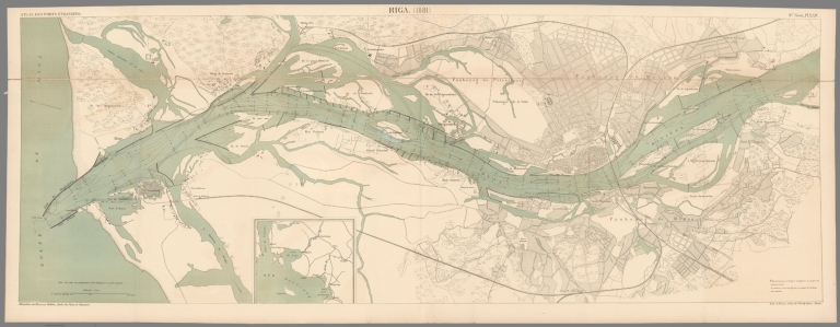
Full Title
Riga. (1881). 4e Série. Pl. XXIV. Ministère des Travaux Publics. Ecole des Ponts et Chaussées. Lith. A. Simon, 13, R. du Val-de-Grâce. Paris.
List No
14306.114
Note
Map showing the port of Rīga, Latvia, in 1879. Features vegetation, railways, streets, bridges, drainage, docks, islands and soundings, with depths given in meters. Includes a bar scale and compass rose, with north oriented toward left of sheet. Descriptive text throughout. Lithograph in black, white and blue. Map is 37 x 103 cm, on fold-out sheet 39 x 107 cm. Bookplate title pasted to verso: Pl. XXIV. Riga. Appears in Quatrième livraison.
Author
[France. Ministère des travaux publics. Administration des routes, France. Direction des cartes, plans et archives et de la statistique graphique, École nationale des ponts et chaussées (France)]
Full Title
Cronstadt et St.-Pétersbourg. (1888). 5e Série. Pl. II. Ministère des Travaux Publics. Ecole des Ponts et Chaussées. Lith. A. Simon, 13, R. du Val-de-Grâce. Paris.
List No
14306.119
Note
Map showing the ports of Kronstadt and Saint Petersburg, Russia, in 1888. Features railways, streets, bridges, drainage, docks, islands and soundings, with depths given in meters. Includes a bar scale. Descriptive text throughout. Lithograph in black, white and blue. Map is 27 x 48 cm, on fold-out sheet 33 x 53 cm. Bookplate title pasted to verso: Pl. II. Saint-Pétersbourg et Cronstadt. Appears in Cinquième livraison.
Author
[France. Ministère des travaux publics. Administration des routes, France. Direction des cartes, plans et archives et de la statistique graphique, École nationale des ponts et chaussées (France)]
Full Title
Passage. (1888) (Pasajes). 5e Série. Pl. V. Ministère des Travaux Publics. Ecole des Ponts et Chaussées. Lith. A. Simon, 13, R. du Val-de-Grâce. Paris.
List No
14306.122
Note
Map showing the port of Pasaia, Spain, in 1888. Features topography, railways, streets, bridges, drainage, docks and soundings, with depths given in meters. Relief shown with hachures. Includes a bar scale and compass rose, with north oriented toward top of sheet. Descriptive text throughout. Lithograph in black, white and blue. With inset map: [Pasaia and vicinity]. Together, maps are 29 x 38 cm, on sheet 33 x 50 cm. Bookplate title pasted to verso: Pl. V. Passage (Pasajes). Appears in Cinquième livraison.
Author
[France. Ministère des travaux publics. Administration des routes, France. Direction des cartes, plans et archives et de la statistique graphique, École nationale des ponts et chaussées (France)]
Full Title
Séville. (1870). 5e Série. Pl. VI. Ministère des Travaux Publics. Ecole des Ponts et Chaussées. Lith. A. Simon, 13, R. du Val-de-Grâce. Paris.
List No
14306.123
Note
Map showing the port of Seville, Spain, in 1870. Features vegetation, railways, streets, bridges, parks, drainage, docks and soundings, with depths given in meters. Includes a bar scale and compass rose, with north oriented toward top of sheet. Descriptive text throughout. Lithograph in black, white and blue. With inset map: [Seville and vicinity]. Together, maps are 27 x 21 cm, on sheet 33 x 25 cm. Appears in Cinquième livraison.
Author
[France. Ministère des travaux publics. Administration des routes, France. Direction des cartes, plans et archives et de la statistique graphique, École nationale des ponts et chaussées (France)]
Full Title
Constnatinople. (1873). 5e Série. Pl. XII. Ministère des Travaux Publics. Ecole des Ponts et Chaussées. Lith. A. Simon, 13, R. du Val-de-Grâce. Paris.
List No
14306.129
Note
Map showing the port of Constnatinople [Istanbul], Turkey, in 1873. Features topography, railways, streets, bridges, drainage, docks and soundings, with depths given in meters. Includes a bar scale. Descriptive text throughout. Lithograph in black, white and blue. With inset map: [Bosphore]. Together, maps are 32 x 46 cm, on fold-out sheet 38 x 50 cm. Bookplate title pasted to verso: Pl. XII. Constantinople. Appears in Cinquième livraison.
Author
[France. Ministère des travaux publics. Administration des routes, France. Direction des cartes, plans et archives et de la statistique graphique, École nationale des ponts et chaussées (France)]
Full Title
Dakar. (1876). 5e Série. Pl. XVI. Ministère des Travaux Publics. Ecole des Ponts et Chaussées. Lith. A. Simon, 13, R. du Val-de-Grâce. Paris.
List No
14306.133
Note
Map showing the port of Dakar, Senegal, in 1876. Title translates to: Tunis and its surroundings. Features topography, vegetation, streets, bridges, drainage, docks and soundings, with depths given in meters. Relief shown with hachures. Includes a bar scale and compass rose, with north oriented toward top of sheet. Descriptive text throughout. Lithograph in black, white and blue. Map is 27 x 22 cm, on sheet 40 x 50 cm. Appears in Cinquième livraison.
Author
[France. Ministère des travaux publics. Administration des routes, France. Direction des cartes, plans et archives et de la statistique graphique, École nationale des ponts et chaussées (France)]
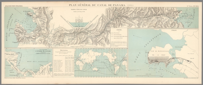
Full Title
Plan général du Canal de Panama. (1886) -- Carte de'ensemble l'Isthme de Panama indiquant l'orientation du canal -- Abréviatoin des principales distances à parcourir par les navigateurs -- [Ile de Manzanillo]. 5e Série. Pl. XVII. Ministère des Travaux Publics. Ecole des Ponts et Chaussées. Lith. A. Simon, 13, R. du Val-de-Grâce. Paris.
List No
14306.134
Note
Four maps showing the Panama Canal, in 1886. Maps feature topography, railways, streets, bridges, drainage and docks and soundings, with depths given in meters. Relief shown with hachures. Two include a bar scale and compass rose, with north oriented toward top-left of sheet. Descriptive text throughout. Lithograph in black, white and blue. With a profile depicting a ship in the canal: Profil type du canal. Together, maps are 28 x 78 cm, on fold-out sheet 33 x 80 cm. Bookplate title pasted to verso: Pl. XVII. Plan général du Canal de Panama. Appears in Cinquième livraison.
Author
[France. Ministère des travaux publics. Administration des routes, France. Direction des cartes, plans et archives et de la statistique graphique, École nationale des ponts et chaussées (France)]
Full Title
Galveston. (1888) -- [Galveston, at a scale of 1/50,000]. 5e Série. Pl. XVIII. Ministère des Travaux Publics. Ecole des Ponts et Chaussées. Lith. A. Simon, 13, R. du Val-de-Grâce. Paris.
List No
14306.135
Note
Two maps showing the port of Galveston, Texas, in 1888. Maps feature topography, vegetation, streets, bridges, drainage, docks and soundings, with depths given in meters. Relief shown with hachures. Each includes a bar scale and the two share a compass rose, with north oriented toward top of sheet. Descriptive text throughout. Lithograph in black, white and blue. Together, maps are 29 x 46 cm, on sheet fold-out 33 x 50 cm. Bookplate title pasted to verso: Pl. XVIII. Galveston. Appears in Cinquième livraison.
Author
[France. Ministère des travaux publics. Administration des routes, France. Direction des cartes, plans et archives et de la statistique graphique, École nationale des ponts et chaussées (France)]
Full Title
Calcutta (Docks). 6e Série. Pl. VIII. Ministère des Travaux Publics. Ecole des Ponts et Chaussées. Lith. A. Simon, 13, R. du Val-de-Grâce. Paris.
List No
14306.151
Note
Map showing the port of Calcutta, India, in 1890. Features railways, streets, bridges, canals, drainage and docks. Includes a bar scale and compass rose, with north oriented toward top of sheet. Descriptive text throughout. Lithograph in black, white and blue. With inset map: [Auckland and vicinity]. Together, maps are 39 x 24 cm, on fold-out sheet 24 x 25 cm. Appears in Sixième livraison.
Author
[France. Ministère des travaux publics. Administration des routes, France. Direction des cartes, plans et archives et de la statistique graphique, École nationale des ponts et chaussées (France)]
Full Title
Auckland, 1884 (Nelle Zélande). 6e Série. Pl. IX. Ministère des Travaux Publics. Ecole des Ponts et Chaussées. Lith. A. Simon, 13, R. du Val-de-Grâce. Paris.
List No
14306.152
Note
Map showing the port of Auckland, New Zealand, in 1884. Features topography, vegetation, railways, streets, bridges, canals, drainage, docks and soundings, with depths given in meters. Relief shown with hachures. Includes a bar scale and compass rose, with north oriented toward top of sheet. Descriptive text throughout. Lithograph in black, white and blue. With inset map: [Auckland and vicinity]. Together, maps are 38 x 43 cm, on fold-out sheet 24 x 50 cm. Bookplate title pasted to verso: Pl. IX. Aukland. Appears in Sixième livraison.
Author
[France. Ministère des travaux publics. Administration des routes, France. Direction des cartes, plans et archives et de la statistique graphique, École nationale des ponts et chaussées (France)]
Full Title
Wellington, 1881 (Nelle Zélande). 6e Série. Pl. X. Ministère des Travaux Publics. Ecole des Ponts et Chaussées. Lith. A. Simon, 13, R. du Val-de-Grâce. Paris.
List No
14306.153
Note
Map showing the port of Wellington, New Zealand, in 1881. Features topography, railways, streets, bridges, drainage, docks and soundings, with depths given in meters. Relief shown with hachures. Includes a bar scale and compass rose, with north oriented toward top-left of sheet. Descriptive text throughout. Lithograph in black, white and blue. Map is 29 x 46 cm, on sheet 33 x 50 cm. Bookplate title pasted to verso: Pl. X. Wellington. Appears in Sixième livraison.
Author
Ad. Mertens
Full Title
Département de l'Ain. Imp. Ad. Mertens, Paris-Bruxelles.
List No
14304.001
Note
Map of the Ain department in France. "Départements" are the second-tier administrative subdivisions of France, below the regions. Shows political boundaries, cities, routes, topography and drainage. Relief shown with hachures. Map appears on an illustration of an unfurled scroll, surrounded by scenery from the corresponding area, including the terrain, flora, fauna, architecture and items of cultural significance, such as regional products. With a coat-of-arms at upper left. Colored chromolithograph on card, with gilded details. Part of a set of 88 cards showing departments of France, as well as French colonies around the world. Verso of each card has an identical advertisement, beginning: Le fil géographique, 40 millions de pelotes par an très lisse, très fort, aussi brillant que la soie ... [= Geographical thread, 40 million spools per year, very smooth, very strong, as shiny as silk ... ]. (Imprint taken from verso; date estimated.)
Author
Ad. Mertens
Full Title
Département des Ardennes. Imp. Ad. Mertens, Paris-Bruxelles.
List No
14304.005
Note
Map of the Ardennes department in France. "Départements" are the second-tier administrative subdivisions of France, below the regions. Shows political boundaries, cities, routes, topography and drainage. Relief shown with hachures. Map appears on an illustration of an unfurled scroll, surrounded by scenery from the corresponding area, including the terrain, flora, fauna, architecture and items of cultural significance, such as regional products. With a coat-of-arms at upper left. Colored chromolithograph on card, with gilded details. Part of a set of 88 cards showing departments of France, as well as French colonies around the world. Verso of each card has an identical advertisement, beginning: Le fil géographique, 40 millions de pelotes par an très lisse, très fort, aussi brillant que la soie ... [= Geographical thread, 40 million spools per year, very smooth, very strong, as shiny as silk ... ]. (Imprint taken from verso; date estimated.)
Author
Ad. Mertens
Full Title
Département de la Corrèze. Imp. Ad. Mertens, Paris-Bruxelles.
List No
14304.018
Note
Map of the Corrèze department in France. "Départements" are the second-tier administrative subdivisions of France, below the regions. Shows political boundaries, cities, routes, topography and drainage. Relief shown with hachures. Map appears on an illustration of an unfurled scroll, surrounded by scenery from the corresponding area, including the terrain, river, flora, fauna, architecture and items of cultural significance, such as regional products. With a coat-of-arms at upper right. Colored chromolithograph on card, with gilded details. Part of a set of 88 cards showing departments of France, as well as French colonies around the world. Verso of each card has an identical advertisement, beginning: Le fil géographique, 40 millions de pelotes par an très lisse, très fort, aussi brillant que la soie ... [= Geographical thread, 40 million spools per year, very smooth, very strong, as shiny as silk ... ]. (Imprint taken from verso; date estimated.)
Author
Ad. Mertens
Full Title
Département du Finistère. Imp. Ad. Mertens, Paris-Bruxelles.
List No
14304.029
Note
Map of the Finistère department in France. "Départements" are the second-tier administrative subdivisions of France, below the regions. Shows political boundaries, cities, routes, topography, drainage and coastline. Relief shown with hachures. Map appears on an illustration of an unfurled scroll, surrounded by scenery from the corresponding area, including the terrain, ocean, flora, fauna, architecture and items of cultural significance, such as regional products. With a coat-of-arms at upper left. Colored chromolithograph on card, with gilded details. Part of a set of 88 cards showing departments of France, as well as French colonies around the world. Verso of each card has an identical advertisement, beginning: Le fil géographique, 40 millions de pelotes par an très lisse, très fort, aussi brillant que la soie ... [= Geographical thread, 40 million spools per year, very smooth, very strong, as shiny as silk ... ]. (Imprint taken from verso; date estimated.)
Author
Ad. Mertens
Full Title
Département des Landes. Imp. Ad. Mertens, Paris-Bruxelles.
List No
14304.047
Note
Map of the Landes department in France. "Départements" are the second-tier administrative subdivisions of France, below the regions. Shows political boundaries, cities, routes, topography, drainage and coastline. Relief shown with hachures. Map appears on an illustration of an unfurled scroll, surrounded by scenery from the corresponding area, including the terrain, ocean, flora, fauna, architecture and items of cultural significance, such as regional products. With a coat-of-arms at upper right. Colored chromolithograph on card, with gilded details. Part of a set of 88 cards showing departments of France, as well as French colonies around the world. Verso of each card has an identical advertisement, beginning: Le fil géographique, 40 millions de pelotes par an très lisse, très fort, aussi brillant que la soie ... [= Geographical thread, 40 million spools per year, very smooth, very strong, as shiny as silk ... ]. (Imprint taken from verso; date estimated.)
Author
Ad. Mertens
Full Title
Département de la Seine. Imp. Ad. Mertens, Paris-Bruxelles.
List No
14304.071
Note
Map of the Seine department in France. "Départements" are the second-tier administrative subdivisions of France, below the regions. Shows political boundaries, cities, routes, topography and drainage. Relief shown with hachures. Map appears on an illustration of an unfurled scroll, surrounded by scenery from the corresponding area, including the terrain, flora, fauna, architecture and items of cultural significance, such as regional products. With a coat-of-arms at top center. Colored chromolithograph on card, with gilded details. Part of a set of 88 cards showing departments of France, as well as French colonies around the world. Verso of each card has an identical advertisement, beginning: Le fil géographique, 40 millions de pelotes par an très lisse, très fort, aussi brillant que la soie ... [= Geographical thread, 40 million spools per year, very smooth, very strong, as shiny as silk ... ]. (Imprint taken from verso; date estimated.)
Author
Ad. Mertens
Full Title
Colonies Françaises (Afrique) : Sénégal -- Mayotte, Nossi-Be, Ste Marie. Imp. Ad. Mertens, Paris-Bruxelles.
List No
14304.082
Note
Two maps of French colonies in Africa the current-day country of Senegal and the islands of Mayotte, Nosy-Be and Sainte-Marie-de-Madagascar (Madagascar). Maps show political boundaries, cities, routes, topography, coastlines and drainage. Relief shown with hachures. Maps appears as insets within illustrated scenery from the corresponding area, including indigenous figures in traditional dress, the terrain, ocean, flora, fauna, architecture and items of cultural significance, such as regional products. Colored chromolithograph on card, with gilded details. Part of a set of 88 cards showing departments of France, as well as French colonies around the world. Verso of each card has an identical advertisement, beginning: Le fil géographique, 40 millions de pelotes par an très lisse, très fort, aussi brillant que la soie ... [= Geographical thread, 40 million spools per year, very smooth, very strong, as shiny as silk ... ]. (Imprint taken from verso; date estimated.)
Author
Ad. Mertens
Full Title
Algérie (Afrique) Province d'Oran. Imp. Ad. Mertens, Paris-Bruxelles.
List No
14304.084
Note
Map of the French colony in Africa, which is the current-day province of Oran (Algeria). Map shows political boundaries, cities, routes, topography, coastline and drainage. Relief shown with hachures. Map appears as an inset within illustrated scenery from the corresponding area, including indigenous figures in traditional dress, the terrain, flora, fauna, architecture and items of cultural significance, such as regional products. Colored chromolithograph on card, with gilded details. Part of a set of 88 cards showing departments of France, as well as French colonies around the world. Verso of each card has an identical advertisement, beginning: Le fil géographique, 40 millions de pelotes par an très lisse, très fort, aussi brillant que la soie ... [= Geographical thread, 40 million spools per year, very smooth, very strong, as shiny as silk ... ]. (Imprint taken from verso; date estimated.)
Author
Ad. Mertens
Full Title
Colonies Françaises (Amérique) : I. St. Barthelemy and I. St. Martin -- I. St. Pierre et Miquelon -- Guyane -- Iles Miquelon. Imp. Ad. Mertens, Paris-Bruxelles.
List No
14304.085
Note
Four maps of French colonies in the Americas: the current-day country of Guyana and the islands of Saint Barthélemy, Saint Pierre and Miquelon. Maps show political boundaries, cities, routes, topography, coastlines and drainage. Relief shown with hachures. Maps appears as insets within illustrated scenery from the corresponding area, including the terrain, flora, fauna, architecture and items of cultural significance, such as regional products. Colored chromolithograph on card, with gilded details. Part of a set of 88 cards showing departments of France, as well as French colonies around the world. Verso of each card has an identical advertisement, beginning: Le fil géographique, 40 millions de pelotes par an très lisse, très fort, aussi brillant que la soie ... [= Geographical thread, 40 million spools per year, very smooth, very strong, as shiny as silk ... ]. (Imprint taken from verso; date estimated.)
Author
Ad. Mertens
Full Title
Colonies Françaises (Océanie) Iles de la Société -- Nle. Calédonie. Imp. Ad. Mertens, Paris-Bruxelles.
List No
14304.088
Note
Two maps of French colonies in Oceania: the current-day Society Islands and New Caledonia Island. Maps show political boundaries, cities, routes, topography, coastlines and drainage. Relief shown with hachures. Maps appears as insets within illustrated scenery from the corresponding area, including an indigenous figure in traditional dress, the terrain, ocean, flora, fauna, architecture and items of cultural significance, such as regional products. Colored chromolithograph on card, with gilded details. Part of a set of 88 cards showing departments of France, as well as French colonies around the world. Verso of each card has an identical advertisement, beginning: Le fil géographique, 40 millions de pelotes par an très lisse, très fort, aussi brillant que la soie ... [= Geographical thread, 40 million spools per year, very smooth, very strong, as shiny as silk ... ]. (Imprint taken from verso; date estimated.)
Author
[Armstrong, George, Wilson, Charles William, Conder, C.R. (Claude Reignier)]
Full Title
Palestine : from the surveys conducted for the committee of the Palestine Exploration Fund and other sources. Compiled by George Armstrong and revised by Colonel Sir Charles W. Wilson K.C.B.,F.R.S. &c. and Major C. R. Conder D.C.L.,R.E. Engraved, printed & pub;ished for the Committee of the Palestine Exploration Fund, at Stanford Geographic Establishment. London 1890.
List No
13432.002
Note
Color map 40x41 on sheet 61x50. Covers City of Sidon and surroundings.
Author
[Armstrong, George, Wilson, Charles William, Conder, C.R. (Claude Reignier)]
Full Title
Palestine : from the surveys conducted for the committee of the Palestine Exploration Fund and other sources. Compiled by George Armstrong and revised by Colonel Sir Charles W. Wilson K.C.B.,F.R.S. &c. and Major C. R. Conder D.C.L.,R.E. Engraved, printed & pub;ished for the Committee of the Palestine Exploration Fund, at Stanford Geographic Establishment. London 1890.
List No
13432.006
Note
Color map on sheet 61x50. Covers Upper Galilee region and cities of Nazareth and Kedesh, Israel.
Author
[Codazzi, Agustín, 1793-1859, Paz, Manuel María, 1820-1902]
Full Title
Plano de Bogota : levantado por el Generale de Ingenieros Agustin Codazzi 1852. Arreglado y publicado por M.M. Paz, Paris 1890 ... Grabado por Erhard Hermanos, 8 Calle Nicole, Paris. (to accompany) Atlas geografico e historico de la Republica de Colombia (Antigua Nueva Granada).
List No
6851.039
Note
Color map. Shows streets, blocks and major buildings. With explanation and tables. Plan of city of Bogota surrounded by illustrations of major establishments, and statues of Colon and Bolivar. Includes notes. Relief shown by formlines.
|