|
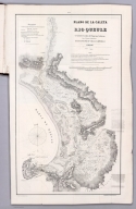
Author
Gormaz, Francisco Vidal, 1837-1907
Full Title
Plano de la Caleta y Rio Queule levantado de orden del Supremo Gobierno por el Teniente 1o. de Marina dn. Francisco Vidal Gormaz. en 1866 i 1867. Lit. Cadot I Brandt, Santiago. Publicado por Decreto Supremo. No. 1.
List No
14329.004
Note
Nautical chart of the Caleta [Agua Fresca Bay] and Río Queule, Chile, from 1866 to 1867. Shows cities, roads, topography, vegetation, drainage, shorelines, shoals, islands and soundings. Relief illustrated with hachures. Includes a legend, coordinate points, two bar scales, a scale statement and a compass rose with north oriented toward top of sheet. Descriptive note beneath title. Text begins: La sonda trazada en el Río i sobre la barra, espresa pies ingleses i ha sido tomada en los momentos de baja marea [= The probe traced in the River and on the bar, expresed in English feet and taken at times of low tide]. Black and white lithograph. Chart is 62 x 35 cm, on fold-out sheet 71 x 44 cm. In first section of atlas, Esploracion hidrográfica de la costa i Ríos de la Araucanía.
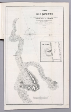
Author
Gormaz, Francisco Vidal, 1837-1907
Full Title
Plano del Rio Queule que comprende desde el punto a. del plano No. 1. hasta el punto donde fue esplorado. Levantado de orden del Supremo Gobierno por el Teniente 1o. de Marina dn. Francisco Vidal Gormaz. en 1866 i 1867. Lit. Cadot I Brandt, Santiago. Publicado por Decreto Supremo. No. 2.
List No
14329.005
Note
Nautical chart of the Río Queule, Chile, from 1866 to 1867. Shows cities, roads, topography, vegetation, drainage, shoreline and soundings. Relief illustrated with hachures. Includes coordinate points, two bar scales and a scale statement, as well arrows indicating the direction of water flow and a compass rose with north oriented toward top of sheet. Descriptive note beneath title. Text begins: El Río Voroa, afluente principal del Queule, es remanso, profundo i navegable por embarcaciones menores en toda la estencion que ha sido esplorado [= The Voroa River, the main tributary of the Queule, is a backwater, deep and navigable by smaller vessels throughout the estuary that has been explored.]. With inset chart: Los Boldos. Black and white lithograph. Chart is 64 x 37 cm, on fold-out sheet 71 x 44 cm. In first section of atlas, Esploracion hidrográfica de la costa i Ríos de la Araucanía.
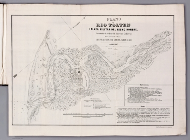
Author
Gormaz, Francisco Vidal, 1837-1907
Full Title
Plano del Rio Tolten i plaza militar del mismo nombre. Levantado de orden del Supremo Gobierno por el Teniente 1o. de Marina dn. Francisco Vidal Gormaz. en 1866 i 1867. Publicado por Decreto Supremo.
List No
14329.006
Note
Nautical chart of the Río Tolten [Toltén River] and the military plaza of the same name, Chile, from 1866 to 1867. Shows cities, roads, topography, vegetation, drainage, shorelines, shoals, islands, anchorage and soundings. Relief illustrated with hachures. Includes a legend, coordinate points, two bar scales and a scale statement, as well arrows indicating the direction of water flow and a compass rose with north oriented toward top right of sheet. Descriptive note in bottom right corner. Text begins: La marea del Océano hincha las aguas del Río pero sin tornar el curso de éstas hácia adentro [= The tide of the ocean swells the waters of the river but without turning the course of these inwards]. Black and white lithograph. Chart is 33 x 49 cm, on fold-out sheet 40 x 54 cm. In first section of atlas, Esploracion hidrográfica de la costa i Ríos de la Araucanía.
Author
[Gormaz, Francisco Vidal, 1837-1907, Molinas, Francisco Javier, Castillo, Luis A.]
Full Title
Plano del Rio Cruces i sus afluentes, levantado de órden del Smo. Gno. durante los meses de Noviembre i Diciembre de 1867 i Enero, Febrero i Marzo de 1868, por La Comision Esploradora del Rio Valdivia, compuesta del Tte. 1o. Fco. Vidal Gormaz, Jefe de ella, i de los Ttes. 2os. Fco. Javier Molinas i Luis A. Castillo. Lita. Cadot I Brandt, Santiago.
List No
14329.007
Note
Nautical chart of the Río Cruces [Cruces River] and its tributaries, Chile, during November and December, 1867, as well as January, February and March, 1868. Shows cities, roads, vegetation, drainage, shorelines, shoals and islands. Includes latitudinal and longitudinal lines, two bar scales and a scale statement, as well a compass rose with north oriented toward top of sheet. Descriptive note beneath title. Text begins: Las lineas fuertes indican la parte esplorada por la Comision i las lineas auxiliares ó cortadas la prolongacion aparente de los Ríos [= The strong lines indicate the part explored by the Commission and the auxiliary or cut lines the apparent prolongation of the rivers]. Black and white lithograph. Chart is 37 x 48 cm, on fold-out sheet 49 x 52 cm. In first section of atlas, Esploracion hidrográfica de la costa i Ríos de la Araucanía.
Author
Kiepert, Heinrich, 1818-1899
Full Title
Erdkarte in Mercators Projection mit Bezeichnung der Meeresstromungen. Beriechtigt 1867. Situation u. Schrift gest. von W. Jaeck.Terrain gestochen von W. Bembe. (to accompany) H. Kiepert's Neuer Handatlas No. 1. Berlin BEI Dietrich Reimer.
List No
11693.008
Note
Double page hand colored in outline map. Showing Ocean Currents and Wind, centered on the Pacific basin, the map covers the entire world. Includes legend. Relief shown by hachures. Prime meridians are Ferro and Paris.
Author
[Alaskan Boundary Tribunal, U.S. Coast Survey]
Full Title
(Facsimile) North Western America Showing the Territory Ceded by Russia to the United States (portion) Compiled for the Department of State at the U.S. Coast Survey Office, B. Peirce, Supt. 1867. Alaskan Boundary Tribunal, 1903. 24. Photo. Lith. by A. Hoen & Co. Baltimore, MD.
List No
0009.067
Note
Tinted. Relief shown by hachures.
Author
[Alaskan Boundary Tribunal, Scott, Robert N.]
Full Title
(Facsimile) Sketch Map of Portland Channel and Vicinity Enclosure "C" (portion). In the Report of Lieutenant Colonel Robert N. Scott, U.S.A., November 12, 1867. Alaskan Boundary Tribunal, 1903. 31. Andrew B. Graham. Photo-Litho. Washington.D.C.
List No
0009.074
Author
Beers, Frederick W.
Full Title
Map of New York and Vicinity Accompanying Atlas of New York and Vicinity, Published by Beers, Ellis & Soule, 95 Maiden Lane, New York.
List No
0063.005
Author
Beers, Frederick W.
Full Title
Plan of New York and Brooklyn.
List No
0063.006
Author
Beers, Frederick W.
Full Title
Plans of Westchester, West Farms, Morrisania, Westchester Co. and Part of New York County.
List No
0063.007
Author
Beers, Frederick W.
Full Title
Town of Yonkers, Westchester Co., N.Y.
List No
0063.008
Author
Beers, Frederick W.
Full Title
Plan of Yonkers, Town of Yonkers, Westchester Co. N.Y.
List No
0063.009
Author
Beers, Frederick W.
Full Title
Plan of East Chester, Pelham and New Rochelle, Westchester Co., N.Y.
List No
0063.010
Author
Beers, Frederick W.
Full Title
Greenburgh, Westchester Co., N.Y.
List No
0063.011
Author
Beers, Frederick W.
Full Title
Plan of Beckmantown, Tarrytown and Irving, West Chester Co. N.Y.
List No
0063.012
Author
Beers, Frederick W.
Full Title
Mamaroneck, Scarsdale, White Plains, Harrison & Rye, Westchester Co., N.Y.
List No
0063.013
Author
Beers, Frederick W.
Full Title
White Plains, Westchester Co. N.Y.
List No
0063.014
Author
Beers, Frederick W.
Full Title
Town of Ossining, Town of Mt. Pleasant, Westchester Co., N.Y. (inset) Pleasantville Station.
List No
0063.015
Author
Beers, Frederick W.
Full Title
Singsing (Sparta), Town of Ossining, Westchester Co. N.Y.
List No
0063.016
Author
Beers, Frederick W.
Full Title
Town of North Castle, Westchester Co., N.Y. (insets) Armonk. Kensico.
List No
0063.017
Author
Beers, Frederick W.
Full Title
Town of Newcastle, Westchester Co., N.Y. (insets) Newcastle. Chappaqua.
List No
0063.018
Author
Beers, Frederick W.
Full Title
Town of Bedford, Westchester Co., N.Y.
List No
0063.019
Author
Beers, Frederick W.
Full Title
Town of Poundridge, Westchester Co., N.Y.
List No
0063.020
Author
Beers, Frederick W.
Full Title
Town of Lewisboro, Westchester Co., N.Y. (insets) Goldens Bridge. Cross River. South Salem.
List No
0063.021
Author
Beers, Frederick W.
Full Title
Town of Cortlandt, Westchester Co., N.Y.
List No
0063.022
Author
Beers, Frederick W.
Full Title
Plan of Peekskill, Westchester Co. N.Y. (inset) Courtland Cemetery.
List No
0063.023
Author
Beers, Frederick W.
Full Title
Town of Yorktown, Westchester Co., N.Y. (insets) Jefferson Valley. Shrub Oak.
List No
0063.024
Author
Beers, Frederick W.
Full Title
Town of Somers, Westchester Co., N.Y. Town of North Salem, Westchester Co., N.Y.
List No
0063.025
Author
Beers, Frederick W.
Full Title
(Town of) Putnam Valley and Philipstown. (inset) Oregon (New York).
List No
0063.026
Author
Beers, Frederick W.
Full Title
Cold Spring, Nelsonville, Westchester Co., N.Y.
List No
0063.027
Author
Beers, Frederick W.
Full Title
Town of Carmel, Winchester Co. N.Y.
List No
0063.028
Author
Beers, Frederick W.
Full Title
Carmel. Towners Station. South East Centre. Mill Town.
List No
0063.029
Author
Beers, Frederick W.
Full Title
Town of South East, Putnam Co., N.Y.
List No
0063.030
Author
Beers, Frederick W.
Full Title
Brewsters Station (Brewster). Patterson.
List No
0063.031
Author
Beers, Frederick W.
Full Title
Town of Patterson, Putnam Co., N.Y.
List No
0063.032
Author
Beers, Frederick W.
Full Title
Town of Kent, Putnam Co., N.Y.
List No
0063.033
Author
Beers, Frederick W.
Full Title
Plan of Dutchess Co. N.Y.
List No
0063.034
Note
Fold-out map.
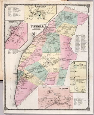
Author
Beers, Frederick W.
Full Title
Fishkill, Dutchess Co. N.Y. Hughsonville. Carthage Landing (Chelsea). New Hackensack. Glenham.
List No
0063.035
Note
Fold-out map.
Author
Beers, Frederick W.
Full Title
Fishkill on the Hudson (Beacon) ... Dutchess Co. N.Y., Matteawan.
List No
0063.036
Note
Fold-out map.
Author
Beers, Frederick W.
Full Title
Fishkill ... Dutchess Co. N.Y. The Fishkill Rural Cemetery.
List No
0063.037
Author
Beers, Frederick W.
Full Title
Channingville, Dutchess Co. N.Y., Wappinger's Falls.
List No
0063.038
Note
Map actually entitled "Town of Channingville..." but it should read "Channingville" since it is a map of the village not a Township map in the sense that the word "Town" is used in this volume.
Author
Beers, Frederick W.
Full Title
Town of East Fishkill. (insets) Johnsville. East Fishkill. Stormville.
List No
0063.039
Author
Beers, Frederick W.
Full Title
Town of Beekman, Dutchess Co., N.Y. (insets) Beekman. Poughquag. Green Haven.
List No
0063.040
Author
Beers, Frederick W.
Full Title
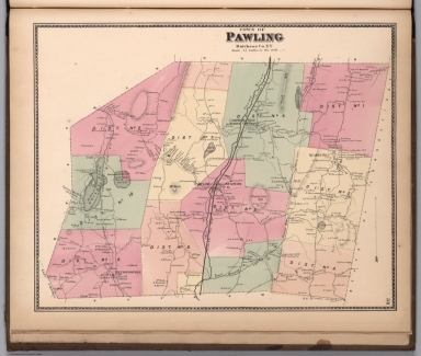
Town of Pawling, Dutchess Co. N.Y.
List No
0063.041
Author
Beers, Frederick W.
Full Title
Town of Poughkeepsie, Dutchess Co. N.Y. (inset) New Hamburgh.
List No
0063.042
Author
Beers, Frederick W.
Full Title
Plan of the City of Poughkeepsie.
List No
0063.043
Author
Beers, Frederick W.
Full Title
Town of Lagrange, Dutchess Co. N.Y. (insets) Washington Hollow. Salt Point.
List No
0063.044
Author
Beers, Frederick W.
Full Title
Unionvale, Dutchess Co. N.Y. (inset) Verbank.
List No
0063.045
Author
Beers, Frederick W.
Full Title
Town of Dover, Dutchess Co. N.Y.
List No
0063.046
Author
Beers, Frederick W.
Full Title
Dover Plains. South Dover. Pawling Station.
List No
0063.047
|