|
Author
[Vallardi, Francesco, Amati]
Full Title
Carta dell'Isola di Sardegna. Milano dal Dott. Franc. Vallardi. Riveduta dal Profe. Amati nel 1865.
List No
14396.072
Note
Political map of the island of Sardinia, Italy. Features political boundaries, cities, railways, roads, topography, bodies of water, drainage, coastline and islands. Relief shown with hachures. Includes a legend, latitudinal and longitudinal lines, as well as three bar scales. Colored engraving. Map is 56 x 42 cm, on double sheet 84 x 60 cm. Within section entitled Isola.
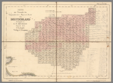
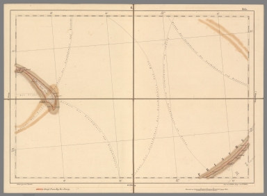
Author
[Reymann, Daniel Gottfried, Flemming, Carl]
Full Title
2 Netz und Arcona
List No
10605.002
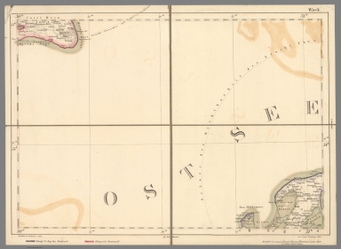
Author
[Reymann, Daniel Gottfried, Flemming, Carl]
Full Title
1 Wieck
List No
10605.001
Author
[Reymann, Daniel Gottfried, Flemming, Carl]
Full Title
3 Musterblatt u. Rützenhagen
List No
10605.003
Author
[Reymann, Daniel Gottfried, Flemming, Carl]
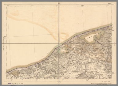
Full Title
4 Leba
List No
10605.004
Note
Date estimated
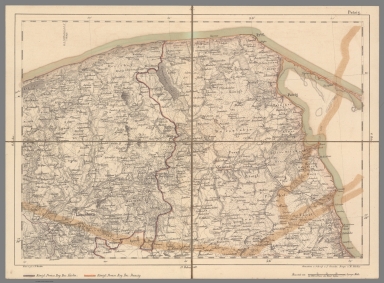
Author
[Reymann, Daniel Gottfried, Flemming, Carl]
Full Title
5 Putzig
List No
10605.005
Author
[Reymann, Daniel Gottfried, Flemming, Carl]
Full Title
6 Hela
List No
10605.006
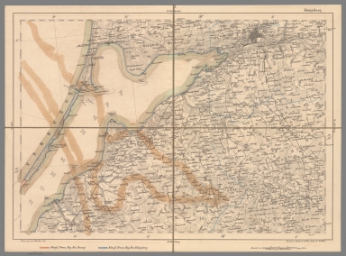
Author
[Reymann, Daniel Gottfried, Flemming, Carl]
Full Title
7 Koenigsberg
List No
10605.007
Note
Date estimated.
Author
[Reymann, Daniel Gottfried, Flemming, Carl]
Full Title
14 Maasstabe u. Langenhagen
List No
10605.019
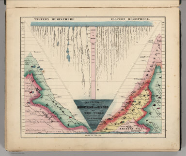
Author
Schonberg & Co.
Full Title
The Principal Mountains and Rivers of the World compiled from the Latest Authorities. New York. Schonberg & Co. 1864.
List No
4324.004
Note
Shows lengths of major rivers and heights of mountains; differentiated by hemisphere.
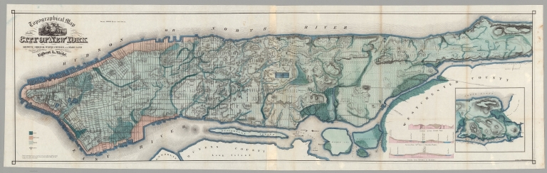
Author
Viele, Egbert L.
Full Title
Topographical Map of the City of New York. Showing Original Water Courses and Made Land. Prepared Under the direction of Egbert L. Viele, Topographical Engineer. Entered ... 1865 by Egbert L. Viele ... New York. Ferd. Mayer & Co. Lithographers, 96 Fulton St. N.Y. (with 1 inset map and 3 profiles).
List No
10156.004
Note
This is a rare variant of Viele's New York City map. It is printed on thin paper and folded into the rear of a small booklet with an essay by Viele explaining the map and its construction and the topography of New York City. The map shows all the original water courses of Manhattan Island, with the street grid superimposed on top. Also, three different kinds of land are shown: Marsh, Made Land, and Meadow. Sewer lines are indicated. This map differs in the title from the more common version issued with the Report on the Sanitary Conditions in New York (see our 3723.000)/ In 1874 Viele reissued the map in larger format as the Topographical Atlas of the City of New York (see our copy).
Author
Anonymous
Full Title
Plano de la Isla de Lobos de Tierra mostrando Los depositos Huano. (to accompany) Las Islas de Huano. Paris. Impr. Lemercier.
List No
11864.002
Note
Plan of the Lobos de Tierra Islands. Showing the area with Guano deposits in orange. Includes notes.
Author
Anonymous
Full Title
Islas de Lobos Tierra. Deposito. B. (to accompany) Las Islas de Huano. Paris. Impr. Lemercier.
List No
11864.004
Note
Map of the Lobos de Tierra Islands. Part B. Showing the area with Guano deposits in orange. Includes explanation. Relief shown by hachures and form lines.
Author
Anonymous
Full Title
Plano de la Isla de Lobos de "Afuera" demostrado los depositos de Huano. (to accompany) Las Islas de Huano. Paris. Impr. Lemercier.
List No
11864.007
Note
Plan of Lobos de Afuera Islands. Showing the deposits of Guano in orange. Includes notes and 2 profile views of the islands at the lower panel. Prime meridian is Paris. Depth shown by soundings.
Author
[Beers, F. W. (Frederick W.), F.W. Beers & Co.]
Full Title
Outline map of Venango Co., Pa. from actual surveys. Published by F.W. Beers & Co., 43 John St., New York. 1865. Entered ... 1865 ... Southern District of New York by F.W. Beers & Co. Ferd. Mayer & Co. Lithographers, 96 Fulton St., N.Y.
List No
0062.001
Note
Hand col. lithographed map. Shows townships, refineries, mills, foundries, etc.
Author
[Beers, F. W. (Frederick W.), F.W. Beers & Co.]
Full Title
Franklin. Entered ... 1865 ... Southern District of New York by F.W. Beers & Co. Ferd. Mayer & Co. Lithographers, 96 Fulton St., N.Y.
List No
0062.002
Note
Hand col. lithographed map. Shows lot numbers, buildings, refineries, etc. Includes business directory.
Author
[Beers, F. W. (Frederick W.), F.W. Beers & Co.]
Full Title
Plan of French Creek Township. (with) Utica. (with) Waterloo, Polk P.O. Entered ... 1865 ... Southern District of New York by F.W. Beers & Co. Ferd. Mayer & Co. Lithographers, 96 Fulton St., N.Y.
List No
0062.003
Note
Hand col. lithographed map. Shows landowners, quarries, etc. Includes business directories. Inset maps at (1:9,900) show buildings, owners, etc.
Author
[Beers, F. W. (Frederick W.), F.W. Beers & Co.]
Full Title
Plan of Sandy Creek Township. Entered ... 1865 ... Southern District of New York by F.W. Beers & Co. Ferd. Mayer & Co. Lithographers, 96 Fulton St., N.Y.
List No
0062.004
Note
Hand col. lithographed map. Shows landowners, etc.
Author
[Beers, F. W. (Frederick W.), F.W. Beers & Co.]
Full Title
Plan of Sugar Creek Township. Entered ... 1865 ... Southern District of New York by F.W. Beers & Co. Ferd. Mayer & Co. Lithographers, 96 Fulton St., N.Y.
List No
0062.005
Note
Hand col. lithographed map. Shows landowners, refineries, etc.
Author
[Beers, F. W. (Frederick W.), F.W. Beers & Co.]
Full Title
Plan of Cranberry Township. (with) Plan of H. Bacharach & Co.'s. oil, coal, iron & timber lands ... (with) Allegheny River Coal Oil Company ... Entered ... 1865 ... Southern District of New York by F.W. Beers & Co. Ferd. Mayer & Co. Lithographers, 96 Fulton St., N.Y.
List No
0062.006
Note
Hand col. lithographed map. Shows landowners, saw mills, etc. Inset map at (ca. 11,300).
Author
[Beers, F. W. (Frederick W.), F.W. Beers & Co.]
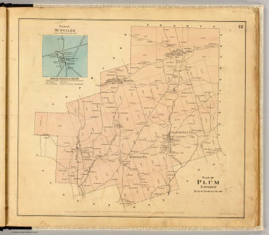
Full Title
Plan of Plum Township. (with) Plan of Sunville ... Entered ... 1865 ... Southern District of New York by F.W. Beers & Co. Ferd. Mayer & Co. Lithographers, 96 Fulton St., N.Y.
List No
0062.007
Note
Hand col. lithographed map. Shows landowners, etc. Inset maps at (ca. 11,880) includes business directory.
Author
[Beers, F. W. (Frederick W.), F.W. Beers & Co.]
Full Title
Plan of Pine Grove Township. Entered ... 1865 ... Southern District of New York by F.W. Beers & Co. Ferd. Mayer & Co. Lithographers, 96 Fulton St., N.Y.
List No
0062.008
Note
Hand col. lithographed map. Shows landowners, etc.
Author
[Beers, F. W. (Frederick W.), F.W. Beers & Co.]
Full Title
Plan of Richland Township. (with) Emlenton. Entered ... 1865 ... Southern District of New York by F.W. Beers & Co. Ferd. Mayer & Co. Lithographers, 96 Fulton St., N.Y.
List No
0062.009
Note
Hand col. lithographed map. Shows landowners, etc. Inset map (1:9,900) shows buildings, owners, etc.; includes business directory.
Author
[Beers, F. W. (Frederick W.), F.W. Beers & Co.]
Full Title
Plan of Oakland Township. (with) Dempseytown. Entered ... 1865 ... Southern District of New York by F.W. Beers & Co. Ferd. Mayer & Co. Lithographers, 96 Fulton St., N.Y.
List No
0062.010
Note
Hand col. lithographed map. Shows landowners, etc. Inset map (1:9,900) shows buildings, owners, etc.; includes business directory.
Author
[Beers, F. W. (Frederick W.), F.W. Beers & Co.]
Full Title
Plan of Rockland Township. (with) Plan of Rockland & Venango Coal Oil Co.'s. lands ... (Entered ... 1865 ... Southern District of New York by F.W. Beers & Co.) Ferd. Mayer & Co. Lithographers, 96 Fulton St., N.Y.
List No
0062.011
Note
Hand col. lithographed map. Shows landowners, etc. Includes 2 inset maps.
Author
[Beers, F. W. (Frederick W.), F.W. Beers & Co.]
Full Title
Plan of Irwin Township. (with) Mechanicsville. Entered ... 1865 ... Southern District of New York by F.W. Beers & Co. Ferd. Mayer & Co. Lithographers, 96 Fulton St., N.Y.
List No
0062.012
Note
Hand col. lithographed map. Shows landowners, etc. Inset map at (1:7,920) shows buildings and owners.
Author
[Beers, F. W. (Frederick W.), F.W. Beers & Co.]
Full Title
Plan of Clinton Township. Entered ... 1865 ... Southern District of New York by F.W. Beers & Co. Ferd. Mayer & Co. Lithographers, 96 Fulton St., N.Y.
List No
0062.013
Note
Hand col. lithographed map. Shows landowners, etc. Includes business directory.
Author
[Beers, F. W. (Frederick W.), F.W. Beers & Co.]
Full Title
Plan of Scrub Grass Township. Entered ... 1865 ... Southern District of New York by F.W. Beers & Co. Ferd. Mayer & Co. Lithographers, 96 Fulton St., N.Y.
List No
0062.014
Note
Hand col. lithographed map. Shows landowners, etc.
Author
[Beers, F. W. (Frederick W.), F.W. Beers & Co.]
Full Title
Plan of Canal Township. Entered ... 1865 ... Southern District of New York by F.W. Beers & Co. Ferd. Mayer & Co. Lithographers, 96 Fulton St., N.Y.
List No
0062.015
Note
Hand col. lithographed map. Shows landowners, etc. Includes Hannaville business directory.
Author
[Beers, F. W. (Frederick W.), F.W. Beers & Co.]
Full Title
Plan of Jackson Township. (with) Coopertown. Entered ... 1865 ... Southern District of New York by F.W. Beers & Co. Ferd. Mayer & Co. Lithographers, 96 Fulton St., N.Y.
List No
0062.016
Note
Hand col. lithographed map. Shows landowners, etc. Inset map at (1:9,900); shows buildings, owners, etc.; includes business directory.
Author
[Beers, F. W. (Frederick W.), F.W. Beers & Co.]
Full Title
Plan of Cherrytree Township. (with) Plan of Cherry Tree Run. (with) Cherrytree. Entered ... 1865 ... Southern District of New York by F.W. Beers & Co. Ferd. Mayer & Co. Lithographers, 96 Fulton St., N.Y.
List No
0062.017
Note
Hand col. lithographed map. Shows landowners, etc. Cherry Tree Run inset at (1:15,840) scale shows lots, etc. Cherrytree inset at (1:11,880) scale shows buildings, owners, etc.; includes business directory.
Author
[Beers, F. W. (Frederick W.), F.W. Beers & Co.]
Full Title
Plan of Allegheny Township. (with) Pleasantville. (with) Plan of Simonds Oil Territory. Entered ... 1865 ... Southern District of New York by F.W. Beers & Co. Ferd. Mayer & Co. Lithographers, 96 Fulton St., N.Y.
List No
0062.018
Note
Hand col. lithographed map. Shows landowners, etc. Pleasantville inset at (1:11,880) scale shows buildings, owners, etc.; includes business directory.
Author
[Beers, F. W. (Frederick W.), F.W. Beers & Co.]
Full Title
Plan of President Township. Entered ... 1865 ... Southern District of New York by F.W. Beers & Co. Ferd. Mayer & Co. Lithographers, 96 Fulton St., N.Y.
List No
0062.019
Note
Hand col. lithographed map. Shows landowners, etc.
Author
[Beers, F. W. (Frederick W.), F.W. Beers & Co.]
Full Title
(Plan of Harmony, Hickory, Kingsley and Tionesta townships). (with) Tionesta Borough. Entered ... 1865 ... Southern District of New York by F.W. Beers & Co. Ferd. Mayer & Co. Lithographers, 96 Fulton St., N.Y.
List No
0062.020
Note
Hand col. lithographed map. Shows landowners, etc.
Author
[Beers, F. W. (Frederick W.), F.W. Beers & Co.]
Full Title
Map of Cornplanter Township. (with) Plan of Pithole Creek. (with) Siverlyville. Entered ... 1865 ... Southern District of New York by F.W. Beers & Co. Ferd. Mayer & Co. Lithographers, 96 Fulton St., N.Y.
List No
0062.021
Note
Hand col. lithographed map. Shows landowners, etc. Pithole Creek inset at (1:31,680) scale. Siverlyville (Siverly, now part of Oil City) inset (scale not given) shows buildings, owners, etc.; includes business directory.
Author
[Beers, F. W. (Frederick W.), F.W. Beers & Co.]
Full Title
Plan of lands on Cherry Run. (with) Plumer. (with) Plan of Keister & Co.'s lands. Entered ... 1865 ... Southern District of New York by F.W. Beers & Co. Ferd. Mayer & Co. Lithographers, 96 Fulton St., N.Y.
List No
0062.022
Note
Hand col. lithographed map. Shows landowners, etc. Includes 3 inset maps and Plumer business directory. Plumer inset at (1:9,900) scale; shows buildings, owners, etc.
Author
[Beers, F. W. (Frederick W.), F.W. Beers & Co.]
Full Title
Sectional plan of Oil Creek. No. 1. Entered ... 1865 ... Southern District of New York by F.W. Beers & Co. Ferd. Mayer & Co. Lithographers, 96 Fulton St., N.Y.
List No
0062.023
Note
Hand col. lithographed map. Shows buildings, lot numbers, landowners, etc. Includes Oil City business directory.
Author
[Beers, F. W. (Frederick W.), F.W. Beers & Co.]
Full Title
Sectional plan of Oil Creek. No. 2. Entered ... 1865 ... Southern District of New York by F.W. Beers & Co. Ferd. Mayer & Co. Lithographers, 96 Fulton St., N.Y.
List No
0062.024
Note
Hand col. lithographed map in 2 segments. Shows buildings, parcel numbers, landowners, etc. Inset map: The McClintock Reserve Oil Co. on J.McClintock farm. Includes McClintockville and Rouseville business directories.
Author
[Beers, F. W. (Frederick W.), F.W. Beers & Co.]
Full Title
Sectional plan of Oil Creek. No. 3. Entered ... 1865 ... Southern District of New York by F.W. Beers & Co. Ferd. Mayer & Co. Lithographers, 96 Fulton St., N.Y.
List No
0062.025
Note
Hand col. lithographed map in 2 segments. Shows buildings, parcel numbers, landowners, etc. Includes Rynd Farm and Tarr Farm business directories.
Author
[Beers, F. W. (Frederick W.), F.W. Beers & Co.]
Full Title
Sectional plan of Oil Creek. No. 4. Entered ... 1865 ... Southern District of New York by F.W. Beers & Co. Ferd. Mayer & Co. Lithographers, 96 Fulton St., N.Y.
List No
0062.026
Note
Hand col. lithographed map in 3 segments. Shows buildings, parcel numbers, landowners, etc.
Author
[Beers, F. W. (Frederick W.), F.W. Beers & Co.]
Full Title
Sectional plan of Oil Creek. No. 5. Entered ... 1865 ... Southern District of New York by F.W. Beers & Co. Ferd. Mayer & Co. Lithographers, 96 Fulton St., N.Y.
List No
0062.027
Note
Hand col. lithographed map in 2 segments. Shows buildings, parcel numbers, landowners, etc. Inset map: Plan of G.H. Bissell & Co. leases on Oil Creek.
Author
[Beers, F. W. (Frederick W.), F.W. Beers & Co.]
Full Title
Titusville. Entered ... 1865 ... Southern District of New York by F.W. Beers & Co. Ferd. Mayer & Co. Lithographers, 96 Fulton St., N.Y.
List No
0062.028
Note
Hand col. lithographed map. Shows buildings, lot numbers, landowners, etc. Includes business directory.
Author
[Beers, F. W. (Frederick W.), F.W. Beers & Co.]
Full Title
Plan of Oil Creek from Titusville to Oil Creek Lake. Entered ... 1865 ... Southern District of New York by F.W. Beers & Co. Ferd. Mayer & Co. Lithographers, 96 Fulton St., N.Y.
List No
0062.029
Note
Hand col. lithographed map in 2 segments. Shows parcel numbers, landowners, etc.
Author
[Beers, F. W. (Frederick W.), F.W. Beers & Co.]
Full Title
Plan of East Branch of Oil Creek, Warren Co. Plan of branch of Oil Creek between Centreville & Spartansburgh, Crawford Co. Entered ... 1865 ... Southern District of New York by F.W. Beers & Co. Ferd. Mayer & Co. Lithographers, 96 Fulton St., N.Y.
List No
0062.030
Note
Two hand col. lithographed maps on 1 sheet. Shows parcel numbers, landowners, etc.
Author
[Beers, F. W. (Frederick W.), F.W. Beers & Co.]
Full Title
Plan of Allegheny River beginning at Clarion Co. line. Entered ... 1865 ... Southern District of New York by F.W. Beers & Co. Ferd. Mayer & Co. Lithographers, 96 Fulton St., N.Y.
List No
0062.031
Note
Hand col. lithographed map in 2 segments. Shows parcel numbers, landowners, townships, etc.
Author
[Beers, F. W. (Frederick W.), F.W. Beers & Co.]
Full Title
Plan of Allegheny River (below Franklin to above Oil City). Entered ... 1865 ... Southern District of New York by F.W. Beers & Co. Ferd. Mayer & Co. Lithographers, 96 Fulton St., N.Y.
List No
0062.032
Note
Hand col. lithographed map in 2 segments. Shows parcel numbers, landowners, townships, etc. Inset maps: Plan of leases on Brandon Farm below Franklin now owned by Bissell, Hoover & Stewart. Scale (1:15,840) -- Plan of leases on Smith Farm below Franklin now Excelsior Oil Co. Scale (1:9,900)
Author
[Beers, F. W. (Frederick W.), F.W. Beers & Co.]
Full Title
Plan of Walnut & Henry's bends, Allegheny River. Entered ... 1865 ... Southern District of New York by F.W. Beers & Co. Ferd. Mayer & Co. Lithographers, 96 Fulton St., N.Y.
List No
0062.033
Note
Hand col. lithographed map. Shows parcel numbers, landowners, townships, etc.
Author
[Beers, F. W. (Frederick W.), F.W. Beers & Co.]
Full Title
Plan of Allegheny River from President to Warren Co. line. Entered ... 1865 ... Southern District of New York by F.W. Beers & Co. Ferd. Mayer & Co. Lithographers, 96 Fulton St., N.Y.
List No
0062.034
Note
Hand col. lithographed map in 2 segments. Shows parcel numbers, landowners, townships, etc.
Author
[Beers, F. W. (Frederick W.), F.W. Beers & Co.]
Full Title
Plan of oil territory, in Warren County. (with) Plan of Tidioute, Warren County. Entered ... 1865 ... Southern District of New York by F.W. Beers & Co. Ferd. Mayer & Co. Lithographers, 96 Fulton St., N.Y.
List No
0062.035
Note
Hand col. lithographed map. Shows parcel numbers, landowners, townships, etc. Includes inset. Tidioute plan at (1:9,900).
Author
[Beers, F. W. (Frederick W.), F.W. Beers & Co.]
Full Title
Index map of the various properties. Property of the Humboldt Mining and Refining Company, for prospectuses &c. apply to Wilson, Gibson & Co., no. 78 & 80 Broadway, New York. (with view) Humboldt Refinery, from the manager's dwelling. (Entered ... 1865 ... Southern District of New York by F.W. Beers & Co. Ferd. Mayer & Co. Lithographers, 96 Fulton St., N.Y.)
List No
0062.036
Note
Hand col. lithographed map. Relief shown by hachures. Shows townships, etc. Includes inset low oblique bird's-eye view.
|