|
Author
[Hughes, William, 1818-1876, Bartholomew, John, 1831-1893]
Full Title
The world on a plane of a meridian. -- The world on the plane of the equator. -- The world on the plane of the horizon of London. By J. Bartholomew, F.R.G.S. George Philip & Son, London & Liverpool.
List No
14487.004
Note
Three maps representing the world, with hemispheres divided between the Western and Eastern Hemispheres, as well as the Southern and Northern Hemispheres, on both the plane of the equator, and the plane of the horizon of London. Maps show political boundaries, cities, topography, bodies of water, drainage, coastlines, and islands. Relief shown with hachures. Maps include latitudinal and longitudinal lines. Scales differ. Colored lithograph. Together, maps are 50 x 60 cm, on double sheet 56 x 70 cm.
Author
[Hughes, William, 1818-1876, Bartholomew, John, 1831-1893]
Full Title
The world on Mercator's projection. By J. Bartholomew, F.R.G.S. George Philip & Son, London & Liverpool.
List No
14487.005
Note
Map representing the world. Shows political boundaries, cities, topography, bodies of water, drainage, coastlines, and islands. Relief shown with hachures. Includes sailing routes and distances. With latitudinal and longitudinal lines. Colored lithograph. Map is 51 x 63 cm, on double sheet 56 x 70 cm.
Author
Hughes, William, 1818-1876
Full Title
The British Empire in 1864 : On a uniform scale of 1:20,000,000 : North America -- The British Islands -- India -- Ascension -- St. Helena -- Falkland -- Bermuda -- Mauritius -- Sketch map of the world, showing the relative positions of the various portions of The British Empire. -- Gibraltar -- Malta -- Heligoland -- Aden -- Hong Kong -- Labuan -- New Zealand -- West Indies -- West Africa -- South Africa -- Norfolk -- Australia. By W. Hughes, F.R.G.S. George Philip & Son, London & Liverpool.
List No
14487.007
Note
Twenty-one maps representing the British Empire in 1864. Maps show political boundaries, cities, bodies of water, drainage, coastlines, and islands. Maps include latitudinal and longitudinal lines, as well as bar scales given in English miles and kilometers. With statistical tables showing square meters and population for each map. Colored lithograph. Together, maps are 51 x 61 cm, on double sheet 56 x 70 cm.
Author
Hughes, William, 1818-1876
Full Title
Industrial map of the British Islands exhibiting the chief localities of manufacturing and commercial industry : With the ratio of population in the different counties, and the towns classified according to their respective populations. By W. Hughes, F.R.G.S. George Philip & Son, London & Liverpool.
List No
14487.008
Note
Map representing industry in the British Isles. With two ancillary maps: Map showing the distribution of the chief mineral productions of The British Islands. -- Map showing the comparative density of population in the different parts of the British Islands. Maps show county boundaries, railways, cities, bodies of water, canals, drainage, coastlines, and islands. Maps include latitudinal and longitudinal lines, as well as a legend and bar scales given in English miles and kilometers. With one inset map: Shetland Isds. Colored lithograph. Together, maps are 61 x 51 cm, on double sheet 70 x 56 cm. With handwritten annotations in red.
Author
[Hughes, William, 1818-1876, Bartholomew, John, 1831-1893]
Full Title
Russia in Europe. By J. Bartholomew, F.R.G.S. George Philip & Son, London & Liverpool.
List No
14487.020
Note
Map representing Russia in Europe. Shows political boundaries, cities, topography, railways, roads, bodies of water, drainage, coastlines, and islands. Relief shown with hachures. Includes latitudinal and longitudinal lines, as well as a legend and bar scales given in English miles, geographical miles, kilometers, and Russian versts. Colored lithograph. Map is 61 x 52 cm, on double sheet 70 x 56 cm.
Author
[Hughes, William, 1818-1876, Weller, Edward, 1819-1884]
Full Title
Asia. By Edwd. Weller, F.R.G.S. George Philip & Son, London & Liverpool.
List No
14487.025
Note
Map representing Asia. Shows political boundaries, cities, topography, roads, bodies of water, drainage, and coastlines. Relief shown with hachures. Includes latitudinal and longitudinal lines, as well as bar scales given in English miles and kilometers. Colored lithograph. Map is 55 x 61 cm, on double sheet 56 x 70 cm.
Author
Hughes, William, 1818-1876
Full Title
Turkey in Asia with Russian Armenia and the countries on the Caucasus. By W. Hughes, F.R.G.S. George Philip & Son, London & Liverpool.
List No
14487.026
Note
Map representing Turkey in Asia. Shows political boundaries, cities, topography, railways, roads, bodies of water, drainage, and coastlines. Relief shown with hachures. Includes latitudinal and longitudinal lines, as well as bar scales given in English miles and kilometers. With: Explanation of terms. Colored lithograph. Map is 51 x 64 cm, on double sheet 56 x 70 cm.
Author
[Hughes, William, 1818-1876, Bartholomew, John, 1831-1893]
Full Title
India. By J. Bartholomew, F.R.G.S. George Philip & Son, London & Liverpool.
List No
14487.028
Note
Map representing India. Shows political boundaries, cities, topography, roads, bodies of water, drainage, and coastlines. Relief shown with hachures. Includes latitudinal and longitudinal lines, as well as a legend, and bar scales given in English miles, geographical miles, and kilometers. With one inset map: Continuation of the eastern provinces, (further India). With: Explanation of colours. Colored lithograph. Map is 62 x 51 cm, on double sheet 70 x 56 cm.
Author
[Hughes, William, 1818-1876, Weller, Edward, 1819-1884]
Full Title
Africa. By Edwd. Weller, F.R.G.S. George Philip & Son, London & Liverpool.
List No
14487.031
Note
Map representing Africa. Shows political boundaries, cities, topography, bodies of water, drainage, and coastlines. Relief shown with hachures. Includes latitudinal and longitudinal lines, as well as bar scales given in English miles and kilometers. Colored lithograph. Map is 53 x 61 cm, on double sheet 56 x 70 cm.
Author
[Hughes, William, 1818-1876, Weller, Edward, 1819-1884]
Full Title
North America. By Edwd. Weller, F.R.G.S. George Philip & Son, London & Liverpool.
List No
14487.032
Note
Map representing North America. Shows political boundaries, cities, topography, bodies of water, drainage, and coastlines. Relief shown with hachures. Includes latitudinal and longitudinal lines, as well as bar scales given in English miles and French kilometers. With one inset map: British Columbia. Colored lithograph. Map is 62 x 54 cm, on double sheet 70 x 56 cm.
Author
[Hughes, William, 1818-1876, Bartholomew, John, 1831-1893]
Full Title
The United States of North America. (North Eastern Division.) By J. Bartholomew, F.R.G.S. George Philip & Son, London & Liverpool.
List No
14487.034
Note
Map representing the Northeast part of the United States of America. Maps show political boundaries, cities, topography, railways, bodies of water, drainage, and coastlines. Relief shown with hachures. Maps include latitudinal and longitudinal lines, as well as bar scales given in English miles, geographical miles, and kilometers. With one inset map: Sketch showing the whole area of the United States. Colored lithograph. Together, maps are 51 x 65 cm, on double sheet 56 x 70 cm.
Author
[Hughes, William, 1818-1876, Bartholomew, John, 1831-1893]
Full Title
The Pacific states, the territories and a portion of the north-western states. (United States, No.II (Western Division.). By J. Bartholomew, F.R.G.S. George Philip & Son, London & Liverpool.
List No
14487.035
Note
Map representing the Western part of the United States of America. Shows political boundaries, cities, indigenous territory, topography, railways, bodies of water, drainage, and coastlines. Relief shown with hachures. Includes latitudinal and longitudinal lines, as well as bar scales given in English miles, geographical miles, and kilometers. Colored lithograph. Map is 52 x 62 cm, on double sheet 56 x 70 cm.
Author
[Hughes, William, 1818-1876, Bartholomew, John, 1831-1893]
Full Title
United States of North America : (South Eastern Division.) The Confederate states, with the border states & the adjoining portion of the federal states. By J. Bartholomew, F.R.G.S. George Philip & Son, London & Liverpool.
List No
14487.036
Note
Map representing the Southeast part of the United States of America. Shows political boundaries, cities, indigenous territory, topography, railways, bodies of water, drainage, and coastlines. Relief shown with hachures. Includes latitudinal and longitudinal lines, as well as bar scales given in English miles, geographical miles, and kilometers. Colored lithograph. Map is 52 x 61 cm, on double sheet 56 x 70 cm.
Author
[Hughes, William, 1818-1876, Bartholomew, John, 1831-1893]
Full Title
Australia. By J. Bartholomew, F.R.G.S. George Philip & Son, London & Liverpool.
List No
14487.040
Note
Map representing Australia. Shows political boundaries, cities, topography, deserts, bodies of water, drainage, coastlines, and islands. Relief shown with hachures. Includes latitudinal and longitudinal lines, as well as bar scales given in English miles, geographical miles, and kilometers. Colored lithograph. Map is 52 x 61 cm, on double sheet 56 x 70 cm.
Author
[Hughes, William, 1818-1876, Bartholomew, John, 1831-1893]
Full Title
New South Wales, Victoria, Queensland, and South Australia. By J. Bartholomew, F.R.G.S. George Philip & Son, London & Liverpool.
List No
14487.041
Note
Map representing Eastern Australia. Shows political boundaries, cities, topography, deserts, bodies of water, drainage, coastlines, and islands. Relief shown with hachures. Includes latitudinal and longitudinal lines, as well as bar scales given in English miles, geographical miles, and kilometers. Colored lithograph. Map is 61 x 52 cm, on double sheet 70 x 56 cm.
Author
Hughes, William, 1818-1876
Full Title
Polynesia. : New Zealand -- The Ladrones or Mariana Islands. -- The Sandwich Islds. -- The Galapogos Is. -- The New Hebrides and Santa Cruz Islands. -- The Feejee, Friendly, and Samoa Islands. -- The Marquesas, Society Islands, and Low Archipelago. By W. Hughes, F.R.G.S. George Philip & Son, London & Liverpool.
List No
14487.042
Note
Seven maps representing Polynesia. Maps show political boundaries, cities, topography, bodies of water, drainage, coastlines, and islands. Relief shown with hachure lines and peak heights. Maps include latitudinal and longitudinal lines, as well as bar scales given in English miles and kilometers; scales differ. New Zealand map indexed to indicate the territories of indigenous peoples. With three inset maps: Norfolk I. -- Enlarged map of Auckland and the adjacent country. -- Enlarged plan of the country round Dunedin : and the eastern portion of the Otago gold-fields. Colored lithograph. Together, maps are 52 x 62 cm, on double sheet 56 x 70 cm.
Author
[Ravenstein, August, Berlin Geographisch-Artistische Anstalt Ernst Schotte]
Full Title
Karten-Ideal zur elementaren Darstellung der topischen Verhältnisse von Wasser und Land auf dem Erdboden, nebst der Oestl. & Westl. Erdhälfte, zur Erläuterung mathemat. eintheilung u. physisch-geograph. Verhältnisse. Zeichnung u. Modell von August Ravenstein in Frankfurt a. M. Stich, Prägung, Druck u. Verlag von B. Dondorf in Frankfurt a. M.
List No
14473.003
Note
Relief map of the world, shown as the Western and Eastern Hemispheres, as well as a closer view of the Netherlands and vicinity. Shows geographical regions, topography, vegetation, bodies of water, drainage, coastlines, shoals and islands. Topography shown with raised relief. Includes latitudinal and longitudinal lines, as well as descriptive notes. Legend for map appears on title page. Colored lithograph. Map is 22 x 27 cm, within frame 24 x 28 cm. Within a series of eight maps comprising the school atlas, Plastischer Schul-Atlas.
Author
[Ravenstein, August, Berlin Geographisch-Artistische Anstalt Ernst Schotte]
Full Title
Deutschland nebst den Königreichen Holland, Belgien und der Republik Schweiz. Zeichnung u. Modell von August Ravenstein in Frankfurt a. M. Stich, Prägung, Druck u. Verlag von B. Dondorf in Frankfurt a. M.
List No
14473.004
Note
Relief map of Germany, the Netherlands, Belgium and Switzerland. Shows geographical regions, countries, cities, railways, canals, topography, vegetation, bodies of water, drainage, coastlines, shoals and islands. Topography shown with raised relief. Includes a legend, bar scale given in miles, latitudinal and longitudinal lines, as well as statistical and descriptive notes. Additional legend for map appears on title page. Colored lithograph. Map is 22 x 27 cm, within frame 24 x 28 cm. Within a series of eight maps comprising the school atlas, Plastischer Schul-Atlas.
Author
[Ravenstein, August, Berlin Geographisch-Artistische Anstalt Ernst Schotte]
Full Title
Europa. Zeichnung u. Modell von August Ravenstein in Frankfurt a. M. Stich, Prägung, Druck u. Verlag von B. Dondorf in Frankfurt a. M.
List No
14473.005
Note
Relief map of Europe. Shows geographical regions, countries, cities, railways, topography, vegetation, bodies of water, drainage, coastlines, shoals and islands. Topography shown with raised relief. Includes a legend, bar scale given in miles, latitudinal and longitudinal lines, as well as statistical and descriptive notes. Additional legend for map appears on title page. With a vignette of scenery, figures, fauna and flora. Colored lithograph. Map is 22 x 27 cm, within frame 24 x 28 cm. Within a series of eight maps comprising the school atlas, Plastischer Schul-Atlas.
Author
[Ravenstein, August, Berlin Geographisch-Artistische Anstalt Ernst Schotte]
Full Title
Asien. Zeichnung u. Modell von August Ravenstein in Frankfurt a. M. Stich, Prägung, Druck u. Verlag von B. Dondorf in Frankfurt a. M.
List No
14473.006
Note
Relief map of Asia. Shows geographical regions, countries, cities, railways, topography, vegetation, bodies of water, drainage, coastlines, shoals and islands. Topography shown with raised relief. Includes a legend, bar scale given in miles, latitudinal and longitudinal lines, as well as statistical and descriptive notes. Additional legend for map appears on title page. With an indexed vignette of scenery, indigenous figures, fauna and flora. Colored lithograph. Map is 22 x 27 cm, within frame 24 x 28 cm. Within a series of eight maps comprising the school atlas, Plastischer Schul-Atlas.
Author
[Ravenstein, August, Berlin Geographisch-Artistische Anstalt Ernst Schotte]
Full Title
Nord-u. Mittel-Amerika. Zeichnung u. Modell von August Ravenstein in Frankfurt a. M. Stich, Prägung, Druck u. Verlag von B. Dondorf in Frankfurt a. M.
List No
14473.007
Note
Relief map of North and Central America. Shows geographical regions, countries, cities, railways, topography, vegetation, bodies of water, drainage, coastlines, shoals and islands. Topography shown with raised relief. Includes a legend, bar scale given in miles, latitudinal and longitudinal lines, as well as statistical and descriptive notes. Additional legend for map appears on title page. With an indexed vignette of scenery, figures, fauna and flora. Colored lithograph. Map is 27 x 22 cm, within frame 28 x 24 cm. Within a series of eight maps comprising the school atlas, Plastischer Schul-Atlas.
Author
[Ravenstein, August, Berlin Geographisch-Artistische Anstalt Ernst Schotte]
Full Title
Südamerika. Zeichnung u. Modell von August Ravenstein in Frankfurt a. M. Stich, Prägung, Druck u. Verlag von B. Dondorf in Frankfurt a. M.
List No
14473.008
Note
Relief map of South America. Shows geographical regions, countries, cities, railways, topography, vegetation, bodies of water, drainage, coastlines, shoals and islands. Topography shown with raised relief. Includes a legend, bar scale given in miles, latitudinal and longitudinal lines, as well as statistical and descriptive notes. Additional legend for map appears on title page. With an indexed vignette of scenery, figures, fauna and flora. Colored lithograph. Map is 27 x 22 cm, within frame 28 x 24 cm. Within a series of eight maps comprising the school atlas, Plastischer Schul-Atlas.
Author
[Ravenstein, August, Berlin Geographisch-Artistische Anstalt Ernst Schotte]
Full Title
Afrika. Zeichnung u. Modell von August Ravenstein in Frankfurt a. M. Stich, Prägung, Druck u. Verlag von B. Dondorf in Frankfurt a. M.
List No
14473.009
Note
Relief map of Africa. Shows geographical regions, countries, cities, railways, topography, vegetation, bodies of water, drainage, coastlines, shoals and islands. Topography shown with raised relief. Includes a legend, bar scale given in miles, latitudinal and longitudinal lines, as well as statistical and descriptive notes. Additional legend for map appears on title page. With an indexed vignette of scenery, figures, fauna and flora. Colored lithograph. Map is 22 x 27 cm, within frame 24 x 28 cm. Within a series of eight maps comprising the school atlas, Plastischer Schul-Atlas.
Author
[Ravenstein, August, Berlin Geographisch-Artistische Anstalt Ernst Schotte]
Full Title
Australien und Polynesien. Zeichnung u. Modell von August Ravenstein in Frankfurt a. M. Stich, Prägung, Druck u. Verlag von B. Dondorf in Frankfurt a. M.
List No
14473.010
Note
Relief map of Australia and Polynesia. Shows geographical regions, countries, cities, railways, topography, vegetation, bodies of water, drainage, coastlines, shoals and islands. Topography shown with raised relief. Includes a legend, bar scale given in miles, latitudinal and longitudinal lines, as well as statistical and descriptive notes. Additional legend for map appears on title page. With an indexed vignette of scenery, figures, fauna and flora. Colored lithograph. Map is 22 x 27 cm, within frame 24 x 28 cm. Within a series of eight maps comprising the school atlas, Plastischer Schul-Atlas.
Author
Wyld, James, 1812-1887
Full Title
Table of the Comparative Heights of the Principal Mountains in the World. Compiled and Drawn in the Quarter Master Generals Department. By James Wyld. Published by James Wyld (Successor to Mr. Faden) Charing Cross East. (inset) Passes of the Alps above level of the sea. (to accompany) An Atlas of the World, Comprehending Separate Maps of its various Countries, Constructed & drawn from the latest Astronomical & Geographical Observations. By James Wyld, Geographer to Her Majesty and H. Late R.H. Prince Albert. London. Published by James Wyld (Successor to Mr. Faden) Charing Cross East. 1864.
List No
2225.006
Note
Printed without color. Includes reference to the name, location and height of the mountains in the world. A late edition of this atlas, published as early as 1836 (see our copy). Several new maps of Australia and South Africa are added and the other maps have been updated to show railroad development. The American maps have been updated, but inadequately so in the West - the River Buenaventura is still flowing out of Salt Lake on the Mexico Map. Half leather cloth-covered boards with stamped title "Wyld's General Atlas" on cover in gold. Maps in color.
Author
Wyld, James, 1812-1887
Full Title
Table of the Comparative Lengths of the Principal Rivers in the World. Compiled and Drawn in the Quarter Master Generals Department. By James Wyld. London, Published by James Wyld (Successor to Mr. Faden) Charing Cross East. (to accompany) An Atlas of the World, Comprehending Separate Maps of its various Countries, Constructed & drawn from the latest Astronomical & Geographical Observations. By James Wyld, Geographer to Her Majesty and H. Late R.H. Prince Albert. London. Published by James Wyld (Successor to Mr. Faden) Charing Cross East. 1864.
List No
2225.007
Note
Printed without color. Includes reference to the name, location and lengths of the rivers in the world. A late edition of this atlas, published as early as 1836 (see our copy). Several new maps of Australia and South Africa are added and the other maps have been updated to show railroad development. The American maps have been updated, but inadequately so in the West - the River Buenaventura is still flowing out of Salt Lake on the Mexico Map. Half leather cloth-covered boards with stamped title "Wyld's General Atlas" on cover in gold. Maps in color.
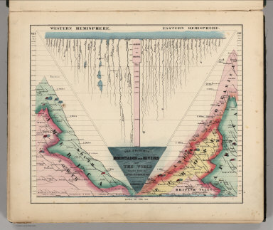
Author
Schonberg & Co.
Full Title
The Principal Mountains and Rivers of the World compiled from the Latest Authorities. New York. Schonberg & Co. 1864.
List No
4324.004
Note
Shows lengths of major rivers and heights of mountains; differentiated by hemisphere.
Author
[Alaskan Boundary Tribunal, Russian Admiralty]
Full Title
(Facsimile) (Russian Admiralty Chart - portion). 1844. Alaskan Boundary Tribunal, 1903. 22. Photo. Lith. by A. Hoen & Co. Baltimore, MD.
List No
0009.065
Author
Bridgens, H.F.
Full Title
A New Map of the State of Pennsylvania, Exhibiting its Internal Improvements, Roads, Distances, &c.
List No
0092.002
Note
Inside front cover. Includes Table of Distances from Lancaster. Population of Pennsylvania, 1860. Includes legend.
Author
Bridgens, H.F.
Full Title
Plan of the City of Lancaster.
List No
0092.006
Author
Bridgens, H.F.
Full Title
Borough of Washington. Borough of Columbia.
List No
0092.007
Note
Includes Business Subscribers/
Author
Bridgens, H.F.
Full Title
Borough of Marietta. Borough of Mount Joy.
List No
0092.008
Note
Includes Business Subscribers.
Author
Bridgens, H.F.
Full Title
Borough of Elizabethtown. Borough of Adamstown.
List No
0092.009
Note
Includes Business Subscribers.
Author
Bridgens, H.F.
Full Title
Borough of Manheim. Borough of Strasburg.
List No
0092.010
Note
Includes Business Subscribers.
Author
Bridgens, H.F.
Full Title
Plan of Manheim Township.
List No
0092.011
Note
Includes Business Subscribers for Neffsville and Dillerville.
Author
Bridgens, H.F.
Full Title
Plan of Upper Leacock Township.
List No
0092.012
Note
Includes Business Subscribers.
Author
Bridgens, H.F.
Full Title
Plan of West Earl Township.
List No
0092.013
Note
Includes Business Subscribers.
Author
Bridgens, H.F.
Full Title
Plan of Earl Township.
List No
0092.014
Note
Includes Business Subscribers.
Author
Bridgens, H.F.
Full Title
Plan of East Earl Township.
List No
0092.015
Note
Includes Business Subscribers.
Author
Bridgens, H.F.
Full Title
Plan of Caernarvon Township.
List No
0092.016
Note
Includes Property Owners.
Author
Bridgens, H.F.
Full Title
Plan of Brecknock Township.
List No
0092.017
Note
Includes Property Owners.
Author
Bridgens, H.F.
Full Title
Plan of East and West Cocalico Townships.
List No
0092.018
Note
Includes Property Owners.
Author
Bridgens, H.F.
Full Title
Plan of Ephrata Township.
List No
0092.019
Note
Includes Property Owners.
Author
Bridgens, H.F.
Full Title
Plan of Elizabeth and Clay Townships.
List No
0092.020
Note
Includes Business Subscribers.
Author
Bridgens, H.F.
Full Title
Plan of Warwick Township.
List No
0092.021
Author
Bridgens, H.F.
Full Title
Plan of Penn Township.
List No
0092.022
Note
Includes Business Subscribers.
Author
Bridgens, H.F.
Full Title
Plan of Rapho Township.
List No
0092.023
Note
Includes Business Subscribers.
Author
Bridgens, H.F.
Full Title
Plan of Mount Joy Township.
List No
0092.024
Note
Includes Business Subscribers.
Author
Bridgens, H.F.
Full Title
Plan of Conoy & West Donegal.
List No
0092.025
Note
Includes Business Subscribers.
Author
Bridgens, H.F.
Full Title
Plan of East Donegal Township.
List No
0092.026
Note
Includes Business Subscribers.
|