|
Author
Berghaus, Heinrich, 1797-1884
Full Title
11. Karte von der Insel Sumatra.
List No
15177.032
Note
With six inset maps: Die Lacca Diven, Die Male Diven, Tschagos Archipelag, Keeling od. Borneo-Korallen Inseln, Indel Singapore, and Bangka Strasse.
Author
[IRISH RAILWAY COMMISSION, LARCOM, Thomas Aiskew (1801 - 1879)]
Full Title
I. Map of Ireland to accompany the Report of the Railway Commissioners 1838. Shewing the lines laid down Under the Direction of the Commissioners and those proposed by Private Parties. / Prepared & Engraved under the direction of Lieu.t Larcom Royal Eng.rs May 1837.
List No
15443.003
Author
[IRISH RAILWAY COMMISSION, HARNESS, Henry Drury (1804 - 1883)]
Full Title
II. Map of Ireland to accompany the Report of the Railway Commissioners shewing the comparative Density of Population. Constructed under the Direction of the Commissioners by Henry D. Harness Lt. Royal Engineers 1837.
List No
15443.004
Author
[IRISH RAILWAY COMMISSION, HARNESS, Henry Drury (1804 - 1883)]
Full Title
III. Map of Ireland, to accompany the Report of the Railway Commissioners shewing the relative Quantities of Traffic in different Directions. Constructed under the Direction of the Commissioners by Henry D. Harness Lt. Royal Engineers 1837.
List No
15443.005
Author
[IRISH RAILWAY COMMISSION, HARNESS, Henry Drury (1804 - 1883)]
Full Title
IV. Map of Ireland, to accompany the Report of the Railway Commissioners shewing the relative Number of Passengers in different Directions by regular Public Conveyances. Constructed under the Direction of the Commissioners by Henry D. Harness Lt. Royal Engineers 1837.
List No
15443.006
Author
[IRISH RAILWAY COMMISSION, Griffith, Richard John (1784-1878)]
Full Title
V. Geological Map of Ireland to accompany the Report of the Railway Commissioners 1837 / Shewing the lines laid down Under the Direction of the Commissioners and those proposed by Joint Stock Companies.
List No
15443.007
Author
[IRISH RAILWAY COMMISSION, LARCOM, Thomas Aiskew (1801 - 1879)]
Full Title
VI. Map of England and Ireland, Explanatory of that part of the Report of the Railway Commissioners, which relates to communication between London and Dublin, and other parts of Ireland. / Prepared & Engraved under the direction of Lieu.t Larcom Royal Eng.rs May 1837.
List No
15443.008
Author
Berghaus, Heinrich, 1797-1884
Full Title
19.(18) Karte vom Ural Gebirge. Gegründet auf die astronomischen Beobachtungen von Wischnewsky, Schubert, A. v. Humboldt, Ad. Erman, und auf handschriftliche Specialkarten
List No
15177.008
Note
Prime Meridian: Paris. - With 1 subtitle: Belaja Gora with surroundings. To: Rose, Gustav: Mineralogical-geognostic journey to the Urals, the Altai and the Caspian Sea.
Author
[Wyld, James, 1812-1887, Wyld, James, 1790-1836]
Full Title
The World on Mercators projection. By James Wyld. 1837. London : Published by James Wyld. (to accompany) A new general atlas of modern geography : consisting of a complete collection of maps of the four quarters of the globe ...
List No
13170.005
Note
Folded engraved, hand-colored in outline map of the world from the early 19th century, it depicts most of the world's broad geographical outlines. Greenland and Antarctica appear much larger relative to land masses near the equator than they actually are. Relief shown by hacures.
Author
[Streit, Friedrich Wilhelm, 1772-1839, Fischer, Wilhelm]
Full Title
Europe : entworfen u. gezeichnet von Dr. F. W. Streit ... Berlin, Verlag von W. Nattorff & Comp. 1836. (to accompany) Atlas von Europa in zwei und achtzig Blattern. (With) Historischer und geographischer Atlas von Europa. Herausgegeben von W. Fischer u. Dr. F.w. Streit.
List No
11742.016
Note
Outline hand colored map. With color coded explanation. Showing political boundaries, major cites, towns, rivers and mountains. Relief shown by hachures.
Author
[Streit, Friedrich Wilhelm, 1772-1839, Fischer, Wilhelm]
Full Title
Das Russische Reich in Europa in 4 blattern : entworfen und gezeichnet von Dr. F. W. Streit. Berlin. Verlag von Natorff et Cp. 1836. (to accompany) Atlas von Europa in zwei und achtzig Blattern. (With) Historischer und geographischer Atlas von Europa. Herausgegeben von W. Fischer u. Dr. F.w. Streit.
List No
11742.072
Note
4 outline hand colored folded maps on 1 sheet. 68. Das Russische Reich in Europa: 68. Nordwestlicher Theil. 69. Nordostlicher Theil. 70.Sudwestlicher Theil. 71. Sudostlicher. Showing administrative boundaries, major cites, villages, roads, landmarks, rivers and canals. Relief shown by hachures. Includes legend.
Author
[Streit, Friedrich Wilhelm, 1772-1839, Fischer, Wilhelm]
Full Title
Uebersicht der vorzuglichsten Hohen Europas : entworfen von Dr. F. W. Streit. Berlin. 1836. Verlag v. Natorff u. Comp. (to accompany) Atlas von Europa in zwei und achtzig Blattern. (With) Historischer und geographischer Atlas von Europa. Herausgegeben von W. Fischer u. Dr. F.w. Streit.
List No
11742.076
Note
Comparative height profile of the heights of mountains in Europe. Includes chart and abbreviation in the lower margin.
Author
Arrowsmith, John
Full Title
British North America, by permission dedicated to the honble. Hudsons Bay Company, containing the latest information which their documents furnish. By their obedient servant J. Arrowsmith. London, pubd. 15 Feby. 1837 by J. Arrowsmith, 35 Essex Street, Strand.
List No
0036.040
Note
Engraved map. Hand colored boundaries. Relief shown by hachures.
Author
Arrowsmith, John
Full Title
Upper Canada &c., by J. Arrowsmith. London, pubd. 15 Feby. 1837 by J. Arrowsmith, 35 Essex Street, Strand.
List No
0036.041
Note
Engraved map. Hand colored boundaries. Relief shown by hachures. Also covers New York and parts of Ohio, Pennsylvania, West Virginia, New Jersey, Connecticut, Massachusetts and Vermont.
Author
Arrowsmith, John
Full Title
Lower Canada, New Brunswick, Nova Scotia, Prince Edwards Id., Newfoundland, and a large portion of the United States. By J. Arrowsmith. London, pubd. 15 Feby. 1837 by J. Arrowsmith, 35 Essex Street, Strand.
List No
0036.042
Note
Engraved map. Hand colored boundaries. Relief shown by hachures. Newfoundland shown in inset. Includes New Hampshire, Maine Rhode Island and parts of adjacent states.
Author
Desjardins, Constant
Full Title
Hydrographische Karte von Europa, oder darstellende Karte der beiden grossen Abdachungen, der Meer- und Flussgebiete etc., etc. der europaischen Halbinsel. Der Jugend gewidmet von C. Desjardins, Mitglied der Pariser Gesellschaften der Geographie ... Zu haben in Wien bei dem Verfasser, Bauernmarkt, Nr. 579, und in allen soliden Buch- und Kunsthandlungen (1837)
List No
0242.001
Note
Color map. Relief shown by hachures. Includes tables. Prime meridians: Ferro and Paris.
Author
Desjardins, Constant
Full Title
Orographische Karte von Europa, oder Beschreibung der Gebirgs-Systeme, Ketten und Landrucken, nebst der Bedeutung der vorzuglishsten Thaler, Haiden, Vorgebirge und Inseln von Europa; der Jugend gewidmet von C. Desjardins. (with) Hochste Spitzen der Haupt-Gebirgskette von Europa. Diese Karte is zu haben in Wien bei dem Herausgeber, Salvatorgasse Nr. 368, in der Kunsthandlung des H.F. Muller, Kohlmarkt, und in allen soliden Kunsthandlungen. (1837)
List No
0242.002
Note
Color map. Relief shown by hachures. Includes text. Prime meridians: Ferro and Paris.
Author
Desjardins, Constant
Full Title
Klima- und Naturproducten-Karte von Europa, oder die Eintheilung Europa's nach den klimatischen Verhaltnissen im Allgemeinen, und den entsprechenden physischen Regionen insbesondere, nebst der Andeutung der vorzuglichsten Thiere, Pflanzen und Mineralien, ihrer Zonen und Hauptvertheilung; der Jugend gewidmet von C. Desjardins. Mit erklarendem Text von J.H. Zu haben in Wien beim Verfasser, Bauernmarkt, Nr. 579, und in allen soliden Buch- und Kunsthandlungen. (1837)
List No
0242.003
Note
Color map. Includes tables. Prime meridians: Ferro and Paris.
Author
Desjardins, Constant
Full Title
Ethnographische Karte von Europa, oder Darstellung der Haputvertheilung der europaischer Volker nach ihren Sprachen und Religions-Verschiedenheiten; der Jugend gewidmet von C. Desjardins, mit erklarendem Text von J.H. Diese Karte ist zu haben in Wien bei dem Herausgeber, Salvatorgasse Nr. 368, und in allen soliden Kunsthandlungen. (1837)
List No
0242.004
Note
Color map. Includes text. Prime meridians: Paris and Ferro.
Author
Desjardins, Constant
Full Title
Militarisch-politische Karte von Europa, mit Angabe der neuesten Gebietseintheilung, Flacheninhalt, absoluten und relativen Bevolkerung, Finanzen und Militar-Kraften, Hauptstadten, Festungen, Universitaten, etc. etc. (with) Mittel-Deutschlands Kleine Staaten. Der Jugend gewidmet von C. Desjardins. Zu haben in Wien bei dem Verfasser, Salvatorgasse Nr. 368, und in allen soliden Kunsthandlungen. (1837)
List No
0242.005
Note
Color map. Includes text and tables. Prime meridians: Paris and Ferro.
Author
Desjardins, Constant
Full Title
Industriell-Commercielle Karte von Europa, oder Skizze der europ. Staaten nach ihren Gewerbs- und Handelsverhaltnissen, nebst Angabe ihrer wichtigsten Handelsplatze, Strassen, Kanale, Eisenbahnen, Dampfschiffsfahrten, etc. etc., der Jugend gewidmet von C. Desjardins. (pasted on at bottom:) Europa's Reichthum in den wichtigsten Erzeugnissen. Beilage zu Nro. 6 des Desjardinschen geographisch-historischen Atlasses. (1837)
List No
0242.006
Note
Color map. Includes text and tables. Prime meridians: Paris and Ferro.
Author
Malte-Brun, Conrad, 1775-1826
Full Title
Geographie des Hebreux, 1831. No. 1. Longitude du Meridien Lutece. Grave par Thierry.
List No
0458.001
Note
Engraved map with country boundaries trimmed in color. Major relief shown by hachures. Rivers, lakes, islands, peoples, and regions shown. Includes 3 scales.
Author
Malte-Brun, Conrad, 1775-1826
Full Title
Geographie Primitive des Grecs. 1831. No. 2. Hesiode, Homere, Orphee, Voyages des Argonautes, et D'Ulysse, neuf siecles avant notre ere. Grave par Thierry.
List No
0458.002
Note
Engraved map with continent boundaries trimmed in color. Shows routes of Ulysses and the Argonauts. Major relief shown by hachures. Rivers, lakes, islands, peoples, and regions shown. Insets showing Systeme de Democrite, 4th century B.C., and Systeme de Scylax d'Eudoxe et d'Ephore, 4th and 5th centuries B.C.
Author
Malte-Brun, Conrad, 1775-1826
Full Title
Geographie d'Herodote, 1831. No. 3. Longitude du Meridien de Lutece. Grave par Thierry.
List No
0458.003
Note
Engraved map with continent boundaries trimmed in color. Major relief shown by hachures. Rivers, lakes, islands, peoples, and regions shown. Text in Latin.
Author
Malte-Brun, Conrad, 1775-1826
Full Title
Systemes Geographiques de Ptolemee, de Strabon & d'Eratosthene, 1831. No. 4. Grave par Thierry.
List No
0458.004
Note
Engraved map with continent boundaries trimmed in color. Major relief shown by hachures. Rivers, lakes, islands, peoples, and regions shown. In three sections: System of Ptolemy at 1:70,000,000; System of Eratosthene at 1:140,000,000; System of Strabon at 1: 140,000,000. Text in Latin.
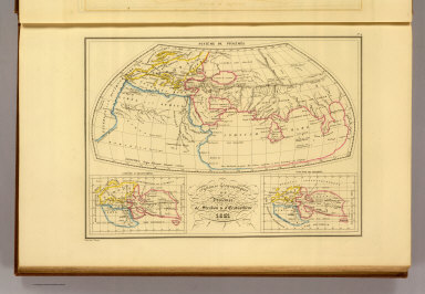
Author
Malte-Brun, Conrad, 1775-1826
Full Title
Empire d'Alexandre. No. 5. Longitude du Meridien de Lutece. Grave par Thierry. (1837)
List No
0458.005
Note
Engraved map with continent boundaries trimmed in color. Major relief shown by hachures. Rivers, lakes, islands, peoples, and regions shown. Text in Latin.
Author
Malte-Brun, Conrad, 1775-1826
Full Title
Monde Connu des Anciens, au IIe Siecle de l'Ere Chretienne. No. 6. Longitude du Meridien de I'lle de Fer. Grave par Thierry. (1837)
List No
0458.006
Note
Engraved map with continent boundaries trimmed in color. Major relief shown by hachures. Rivers, lakes, islands, and regions shown. Shows 14 scales. Text in Latin.
Author
Malte-Brun, Conrad, 1775-1826
Full Title
Europe Ancienne, 1831. No. 7. Longitude du Meridien de Lutece. Grave par Thierry.
List No
0458.007
Note
Engraved map with continent boundaries trimmed in color. Major relief shown by hachures. Rivers, lakes, islands, and regions shown. Includes 4 different scales. Text in Latin.
Author
Malte-Brun, Conrad, 1775-1826
Full Title
Asie Ancienne, 1831. No. 8. Longitude du Meridien de Lutece. Grave par Thierry.
List No
0458.008
Note
Engraved map with continent boundaries trimmed in color. Major relief shown by hachures. Rivers, lakes, islands, and regions shown. Text in Latin.
Author
Malte-Brun, Conrad, 1775-1826
Full Title
Asie Mineure Ancienne, 1831. No. 8, bis. Grave par Thierry.
List No
0458.009
Note
Engraved map with region boundaries trimmed in color. Major relief shown by hachures. Rivers, lakes, islands, and regions shown. Includes 4 scales. Text in Latin.
Author
Malte-Brun, Conrad, 1775-1826
Full Title
Afrique Ancienne. No. 9. Longitude du Meridien de Lutece. Grave par Thierry.
List No
0458.010
Note
Engraved map with continents trimmed in color. Major relief shown by hachures. Rivers, lakes, islands, and regions shown. Includes 5 scales. Text in Latin.
Author
Malte-Brun, Conrad, 1775-1826
Full Title
Palestine, Royaume des Israelites sous David et Salomon, Les Douze Tribus. No. 10. Longitude du Meridien de Lutece. Grave par Thierry.
List No
0458.011
Note
Engraved historical map in three sections: Israel and Lebanon at 1,850,000; Syria at 8,500,000; and northern Israel at 3,830,000. Regions trimmed in color. Major relief shown by hachures. Rivers, lakes, islands, and regions shown. Includes 5 scales. Text in Latin.
Author
Malte-Brun, Conrad, 1775-1826
Full Title
Egypte Ancienne. No. 11. Longitude du Meridien de Lutece. Grave par Thierry.
List No
0458.012
Note
Engraved map. Regions trimmed in color. Major relief shown by hachures. Rivers, lakes, islands, and regions shown. Includes 4 scales. Text in Latin.
Author
Malte-Brun, Conrad, 1775-1826
Full Title
Grece Ancienne au Commencement de l'Ere Chretienne. No. 12. Longitude du Meridien de Lutece. Grave par Thierry.
List No
0458.013
Note
Engraved map. Regions trimmed in color. Major relief shown by hachures. Rivers, lakes, islands, and regions shown. Includes 4 scales. Text in Latin.
Author
Malte-Brun, Conrad, 1775-1826
Full Title
Italie Ancienne. No. 13. Longitude du Meridien de Lutece. Grave par Thierry.
List No
0458.014
Note
Engraved map. Regions trimmed in color. Major relief shown by hachures. Rivers, lakes, islands, and regions shown. Includes 2 scales.
Author
Malte-Brun, Conrad, 1775-1826
Full Title
Espagne Ancienne. No. 15. Grave par Thierry.
List No
0458.015
Note
Engraved map. Regions trimmed in color. Major relief shown by hachures. Rivers, lakes, islands, and regions shown. Includes 2 scales.
Author
Malte-Brun, Conrad, 1775-1826
Full Title
Carte des Gaules, Divisee en Provinces Romaines et Comprenaus les Conquetes des Francs, les Possessions des Visigoths, Escelles des Ostrogoths et le Royaume de Bourguignons jusque au Commencement de VIe. Siecle. No. 16. Longitude du Meridien de Lutece. Grave par Thierry. (1837)
List No
0458.016
Note
Engraved map. Regions in color. Rivers, lakes, islands, and regions shown. Includes 4 scales. Text in Latin.
Author
Malte-Brun, Conrad, 1775-1826
Full Title
Empire Romain sous Constantin et sous Trajan. No. 18. Longitude du Meridien de Lutece. Grave par Thierry. (1837)
List No
0458.017
Note
Engraved map. Regions trimmed in color. Rivers, lakes, islands, and regions shown. Includes 4 scales. Text in Latin.
Author
Malte-Brun, Conrad, 1775-1826
Full Title
Table Theodosienne Dite Carte de Peutinger. (Carte routiere de l'Empire romain, reduite au sixieme de la grandeur du manuscrit que existe a la Bibliotheque Imperiale et Royale de Vienne.) No. 19. Grave par Thierry. (1837)
List No
0458.018
Note
Engraved linear map in three strips. Major relief shown in hachures. Rivers, lakes, islands, and regions shown. Map is a reduced scale version of the Peutinger Table, a 13th century copy of a linear-style map of the Roman road system probably from the 3rd century. The 13th century copy, now in Vienna, is 22 feet long and one foot wide.
Author
Malte-Brun, Conrad, 1775-1826
Full Title
Europe apres l'Invasion des Barbares au 3e. siecle a la Fin du Ve. et pendant une partie du VIe. No. 15. Grave par Thierry. Longitude du Meridien de Lutece. (1837)
List No
0458.019
Note
Engraved map. Land trimmed in color. Rivers, lakes, islands, peoples, and regions shown. Includes 3 scales. Provides color-coded routes of 12 invader groups.
Author
Malte-Brun, Conrad, 1775-1826
Full Title
Europe en 1100 indiquant la date de la Fondation des Differens Etats. No. 17. Grave par Thierry. (1837)
List No
0458.020
Note
Engraved map. Countries in full solid color. Rivers, lakes, islands, peoples, and regions shown. Includes 3 scales. Includes list of divisions of France and corresponding dates keyed to map. Dates of various European kingdoms also shown on map.
Author
Malte-Brun, Conrad, 1775-1826
Full Title
Geographie du Moyen Age, Principalement au IXe. Siecle. No. 19. Longitude de Meridien de Paris. Grave par Thierry. (1837)
List No
0458.021
Note
Engraved map. Countries trimmed in color. Rivers, lakes, islands, and regions shown. Includes 3 scales. Inset of Greenland and Vinland.
Author
Malte-Brun, Conrad, 1775-1826
Full Title
Empire des Mongols. No. 20. Grave par Thierry. (1837)
List No
0458.022
Note
Engraved map. Countries trimmed in color. Rivers, lakes, islands, and regions shown. Includes 2 scales.
Author
Malte-Brun, Conrad, 1775-1826
Full Title
Carte Geologique d'Europe. Dressee par J.J.N. Huot, d'apres les travaux de M.M.A. Boue d'Omalius d'Halloy, de Buch et autres geologistes. No. 20 bis. Grave par Thierry. (1837)
List No
0458.023
Note
Engraved map. Geologic units listed in legend and depicted in full color. Major relief depicted with hachures. Rivers, lakes, islands, and regions shown. Includes 4 scales.
Author
Malte-Brun, Conrad, 1775-1826
Full Title
Carte Physique et Mineralogique des Isles Britanniques presentus les Bassins, les principales Montagnes, les Cours d'Eau, les Roches, et les substances Minerales. 1832. Grave par Thierry.
List No
0458.024
Note
Engraved map. Geologic units listed and described in legend and depicted in full color. Major relief depicted with hachures. Rivers, lakes, islands, and basins shown. Includes 2 scales.
Author
Malte-Brun, Conrad, 1775-1826
Full Title
Carte Physique et Mineralogique de la France presentant les Versans, les Bassins, les Montagnes, les Grandes Limites des Vegetation, la Pente des Principaux Cours d'Eau, les Roches, et les Substances Minerales, que recele son Sol. 1832. No. 21. Grave par Thierry.
List No
0458.025
Note
Engraved map. Geologic units listed and described in legend and depicted in full color. Major relief depicted with hachures. Rivers, lakes, islands, watersheds, and basins shown. Includes 2 scales. Inset of Corsica.
Author
Malte-Brun, Conrad, 1775-1826
Full Title
Mappe-Monde, Suivant la Projection de Mercator. No. 27. Grave par Thierry. (1837)
List No
0458.027
Note
Engraved map. Continents trimmed in color. Rivers, lakes, islands, and regions shown.
Author
Malte-Brun, Conrad, 1775-1826
Full Title
Mappemonde, en Deux Hemispheres, 1833. Longitude du Meridien de Paris. Hemisphere Oriental. Hemisphere Occidental. No. 28. Grave par Thierry.
List No
0458.028
Note
Engraved map. Continents trimmed in color. Rivers, lakes, islands, and regions shown. Major relief shown by hachures.
Author
Malte-Brun, Conrad, 1775-1826
Full Title
Europe, 1834. No. 29. Grave par Thierry.
List No
0458.029
Note
Engraved map. Countries trimmed in color. Rivers, lakes, islands, and regions shown. Major relief shown by hachures. Includes 4 scales.
Author
Malte-Brun, Conrad, 1775-1826
Full Title
France en 1789. No. 30. Grave par Thierry. (1837)
List No
0458.030
Note
Engraved map. Countries and districts trimmed in color. Rivers, lakes, islands, and regions shown. Major relief shown by hachures. Includes 3 scales.
|