|
Author
[Dépôt General de la Marine, Beautemps Beaupré, Charles François, 1766-1854]
Full Title
Carte particuliêre des Côtes de France (Rade de Brest et Baie de Douarnenez) levée en 1816 et 1817. Par les Ingénieurs Hydrographes de la Marine, sous les Ordres de M. Beautemps-Beaupré Ingénieur Hydrographe en Chef, Membre de l'Académie Royale des Sciences de l'Institut de France et de la Societé Royale des Sciences de Gællingen. Publiée par Ordre du Roi sous le Ministère de son Excellence M. le Marquis de Clermont-Tonnerre. Pair de France, Secrétaire d'Etat an Département de la Marine et des Colonies. Au Dépôt-général de la Marine en 1825. Gravé par E. Collin. Ecrit par Besançon.
List No
14392.010
Note
Nautical chart of the coast in the vicinity of Rade de Brest and the Bay of Douarnenez, France, surveyed in 1816 and 1817. Shows cities, ports, topography, vegetation, bodies of water, drainage, coastlines, shoals, islands, depths and anchorage. Relief shown with hachures. Includes a legend, rhumb lines, latitudinal and longitudinal lines, as well as explanatory text. Seal: Dépôt Général de la Marine. Black and white engraving. Map is 86 x 57 cm, on double sheet 90 x 62 cm. Created by the Hydrographic Engineers of the Navy, under the Orders of Beautemps-Beaupré, Chief Hydrographic Engineer, Member of the Royal Academy of Sciences of the Institut de France and the Royal Society of Sciences of Gællingen. Published by Order of the King under the Ministry of His Excellency M. le Marquis de Clermont-Tonnerre, Peer of France, Secretary of State in the Department of the Navy and the Colonies, at the Depot-General of the Navy in 1825. "No. 113."
Author
Borghi, Bartolomeo, 1750-1821
Full Title
Mappa mondo emisfero antico, dell'A. B. Borghi. Firenze 1817. Ago. Costa Inc.
List No
14255.008
Note
Engraved spherical, historical map of the Eastern Hemisphere, depicting the ancient world, with hand-colored outlines delineating boundaries. Title translates to: [Ancient hemisphere world map]. Shows political boundaries, topography, drainage, coastlines and islands. Relief shown pictorially. With latitudinal and longitudinal lines. One in a pair of hemisphere maps, which continues on next plate (8). Imprint beneath title. Map is 25 x 32 cm, on sheet 35 x 47 cm.
Author
Borghi, Bartolomeo, 1750-1821
Full Title
L'Impero Russo in Europa, in quattro fogli, dell'A. B. Borghi. Firenze 1817. Incisa nello Studio Giarre (1).
List No
14255.020
Note
Engraved political map of the Russian Empire in Europe, with hand-colored outlines delineating boundaries. Title translates to: [The Russian Empire in Europe]. Shows political boundaries, topography, drainage, coastlines, islands and routes of travel. Relief shown pictorially. With latitudinal and longitudinal lines, as well as two bar scales and a descriptive note. Imprint beneath title. First (northeast) in a series of four sheets that together comprise the full map (plates 19-22). Sheet is 30 x 22 cm, on sheet 47 x 35 cm. Descriptive text appears on prior plate (17).
Author
Borghi, Bartolomeo, 1750-1821
Full Title
L'Impero Russo in Europa, in quattro fogli, dell'A. B. Borghi. Firenze 1817. Incisa nello Studio Giarre (2).
List No
14255.021
Note
Engraved political map of the Russian Empire in Europe, with hand-colored outlines delineating boundaries. Title (from first sheet, on plate 19) translates to: The Russian Empire in Europe]. Shows political boundaries, topography, drainage, coastlines, islands and routes of travel. Relief shown pictorially. With latitudinal and longitudinal lines. Additionally, includes two bar scales and a descriptive note on first sheet. Second (northwest) in a series of four sheets that together comprise the full map (plates 19-22). (Title and imprint taken from first sheet.) Sheet is 30 x 22 cm, on sheet 47 x 35 cm. Descriptive text appears on prior plate (17).
Author
Borghi, Bartolomeo, 1750-1821
Full Title
L'Impero Russo in Europa, in quattro fogli, dell'A. B. Borghi. Firenze 1817. Incisa nello Studio Giarre (3).
List No
14255.022
Note
Engraved political map of the Russian Empire in Europe, with hand-colored outlines delineating boundaries. Title (from first sheet, on plate 19) translates to: The Russian Empire in Europe]. Shows political boundaries, topography, drainage, coastlines and routes of travel. Relief shown pictorially. With latitudinal and longitudinal lines. Additionally, includes two bar scales and a descriptive note on first sheet. Third (southwest) in a series of four sheets that together comprise the full map (plates 19-22). (Title and imprint taken from first sheet.) Also, with inset: [Cracovia]. Sheet is 30 x 22 cm, on sheet 47 x 35 cm. Descriptive text appears on prior plate (17).
Author
Borghi, Bartolomeo, 1750-1821
Full Title
L'Impero Russo in Europa, in quattro fogli, dell'A. B. Borghi. Firenze 1817. Incisa nello Studio Giarre (4).
List No
14255.023
Note
Engraved political map of the Russian Empire in Europe, with hand-colored outlines delineating boundaries. Title (from first sheet, on plate 19) translates to: The Russian Empire in Europe]. Shows political boundaries, topography, drainage, coastlines, islands and routes of travel. Relief shown pictorially. With latitudinal and longitudinal lines. Additionally, includes two bar scales and a descriptive note on first sheet. Fourth (southeast) in a series of four sheets that together comprise the full map (plates 19-22). (Title and imprint taken from first sheet.) Also, with inset: [Cracovia]. Sheet is 29 x 22 cm, on sheet 47 x 35 cm. Descriptive text appears on prior plate (17).
Author
Weiland, Carl Ferdinand, 1782 -1847
Full Title
(Composite map of) Sections 1-22.
List No
7976.026
Note
Date of folio.
Author
[Humboldt, Alexander von, 1769-1859, Bonpland, Aime, Marchais, L., de Buch, Leopold, Smith, Chr.]
Full Title
II. Tableau physique des iles Canaries. Geographie des plantes du Pic de Teneriffe.
List No
12125.024
Author
Thomson, John
Full Title
Hydrographical chart of the World on Wright or Mercators projection with tracts of the last circumnavigators. R. Scott sculpt. Drawn and engraved for John Thompson Junr. & Co., Edinburgh, 1814.
List No
1007.002
Note
Engraved map. Outline hand color. Relief shown pictorially.
Author
Thomson, John
Full Title
Northern Hemisphere. Kirkwood sculp. Drawn & engraved for John Thompson Co.'s New general atlas, 12 August 1814.
List No
1007.003
Note
Engraved map. Hand colored. Relief shown pictorially.
Author
Thomson, John
Full Title
Southern Hemisphere. Kirkwood sculp. Drawn & engraved for John Thompson Co.'s New general atlas, 12 August 1814.
List No
1007.004
Note
Engraved map. Hand colored. Relief shown pictorially.
Author
Thomson, John
Full Title
Eastern Hemisphere. Drawn & engraved for Thomson's New general atlas, 1815.
List No
1007.005
Note
Engraved map. Hand colored. Relief shown pictorially.
Author
Thomson, John
Full Title
Western Hemisphere. Drawn & engraved for Thomson's New general atlas, 1815.
List No
1007.006
Note
Engraved map. Hand colored. Relief shown pictorially.
Author
[Buchanan, George, Thomson, John]
Full Title
Northern Hemisphere projected on the plane of the horizon of London. By Geo. Buchanan. J. & G. Menzies sculpt., Edinr. Projected & engraved for Thomson's New general atlas, 20th Sept. 1816.
List No
1007.007
Note
Engraved map. Outline hand color. Relief shown by hachures. "N.B. The scale is quite correct for distances from London; it is also very nearly so for distances on any part of the meridian of London or on any lines passing through London."
Author
[Buchanan, George, Thomson, John]
Full Title
Southern Hemisphere projected on the plane of the horizon of London. By Geo. Buchanan. J. & G. Menzies sculpt., Edinr. Projected & engraved for Thomson's New general atlas, 20th Sept. 1816.
List No
1007.008
Note
Engraved map. Outline hand color. Relief shown by hachures. "N.B. The scale only measures with sufficient accuracy distances in the direction of the meridians."
Author
Thomson, John
Full Title
Europe. J. & G. Menzies sculpt. (1817)
List No
1007.009
Note
Engraved map. Hand color. Relief shown pictorially.
Author
Thomson, John
Full Title
British Isles. Drawn & engraved by Hewitt, Broad Str., Bloomsby. Drawn & engraved for Thomson's New general atlas, May 1st, 1815.
List No
1007.010
Note
Engraved map. Hand colored. Relief shown by hachures. Includes inset of Orkney and Shetland islands.
Author
Thomson, John
Full Title
Ireland. Neale (i.e. Neele) sculpt., Strand, London. Drawn & engraved for Thomson's New general atlas Feby. 1815.
List No
1007.011
Note
Engraved map. Hand colored. Relief shown by hachures.
Author
Thomson, John
Full Title
Scotland. Drawn & engraved by Hewitt, Broad Str(ee)t., Bloomsbury. Drawn and engraved for Thomson's New general atlas. April 1st, 1815.
List No
1007.012
Note
Engraved map. Hand colored. Relief shown by hachures. Includes inset of the Shetland and Orkney islands.
Author
Thomson, John
Full Title
England. Neele sculpt., Strand, London. Drawn & engraved for Thomson's New general atlas, Septr. 16, 1814.
List No
1007.013
Note
Engraved map. Hand colored. Relief shown by hachures. Shows ship routes, roads, settlements, counties, etc.
Author
Thomson, John
Full Title
Remote British islands. Drawn & engraved by N.R. Hewitt, Grafton Strt., East Tottenham Court Road. Drawn & engraved for Thomson's New general atlas. Jany. 1st, 1817.
List No
1007.014
Note
Five engraved maps and 2 views. Outline hand color. Relief shown by hachures. Contents: Isles of Guernsey, Herm, Sark and Alderney. Scale 1:250,000 -- Isle of Jersey. Scale 1:150,000 -- Isles of Scilly. Scale 1:120,000 -- Isle of Mann. Scale 1:180,000 -- Isle of Wight. Scale 1:160,000 -- View of Eddystone Light House -- Freshwater Bay, in the Isle of Wight, with a distant view of the Needle Rocks.
Author
Thomson, John
Full Title
The British Channel. J. & G. Menzies sculpt., Edinr. Drawn & engraved for Thomson's New general atlas, 16th Sept. 1814.
List No
1007.015
Note
Engraved map. Hand colored.
Author
Thomson, John
Full Title
Chart of the North and Baltic seas, &c. (with) Harbour of Heligoland. (with) Port of Revel. (with) Harbour of St. Petersburg. Neele sc., Strand. Drawn & engraved for Thomson's New general atlas, 1816.
List No
1007.016
Note
Engraved map with 3 ancillary maps. Hand colored. Depths shown by soundings.
Author
Thomson, John
Full Title
Scandinavia, or Sweden, Denmark & Norway. J. & G. Menzies sculpt., Edinbr. (Drawn & engraved for Thomson's New general atlas, 1817)
List No
1007.017
Note
Engraved map. Hand colored.
Author
Thomson, John
Full Title
Denmark. (with) Iceland. (with) Feroe Islands. Engd. by W. Dassauville, Edin. Drawn & engraved for Thomson's New general atlas, 14th July 1814.
List No
1007.018
Note
Engraved map with 2 insets. Hand colored. Relief shown by hachures.
Author
Thomson, John
Full Title
Germany north of the Mayne. Neele sc., Strand, London. Drawn & engraved for Thomson's New general atlas, 1816.
List No
1007.019
Note
Engraved map. Hand colored. Relief shown by hachures.
Author
Thomson, John
Full Title
Holland. Neele sculpt., London. Drawn & engraved for Thomson's New general atlas, 16th Septr. 1814.
List No
1007.020
Note
Engraved map. Hand colored.
Author
Thomson, John
Full Title
Belgium or the Netherlands. Drawn and engraved for Thomson's New general atlas, 1815.
List No
1007.021
Note
Engraved map. Hand colored.
Author
Thomson, John
Full Title
France. Engd. by Kirkwood & Son, Edinr. (Drawn & engraved for Thomson's New general atlas, 1817)
List No
1007.022
Note
Engraved map. Hand colored. Relief shown pictorially.
Author
Thomson, John
Full Title
France, in provinces. Kirkwood sculpt. Drawn & engraved for Thomson's New general atlas, 12 August 1814.
List No
1007.023
Note
Engraved map. Hand colored. Relief shown by hachures.
Author
Thomson, John
Full Title
Spain & Portugal. J. & G. Menzies sculpt., Edinr. Drawn & engraved for Thomson's New general atlas, 21st Augt. 1815.
List No
1007.024
Note
Engraved map. Hand colored. Relief shown by hachures.
Author
Thomson, John
Full Title
Chart of the Mediterranean Sea. (with) Bay & roads of Marseilles. (with) The harbour of Genoa. (with) Plan of the rock and bay of Gibraltar shewing the position of the combined fleet and attack of the battering ships in 1782. (with) Leghorn Road. (with) Sketch of the watering place of Algeziras. (with) Attack on Algiers by the fleet under the command of Adml. Lord Exmouth, Augst. 27th 1816. (with) Gulf of Smyrna. Neele sculp., Strand. Drawn & engraved for Thomson's New general atlas, 1817.
List No
1007.025
Note
Engraved map with 7 inset maps. Outline hand color. Relief shown by hachures; depths by soundings in insets.
Author
Thomson, John
Full Title
Attica. Turkish dominions in Europe. E. Mitchell sculpt. Drawn and engraved for Thomson's New general atlas, 1815.
List No
1007.026
Note
Two engraved maps on 1 sheet. Hand colored. Relief shown by hachures.
Author
Thomson, John
Full Title
Italy. (with) Island of Elba. R. Scott, sculpt. Drawn & engraved for Thomson's New general atlas, 1814.
List No
1007.027
Note
Engraved map with inset. Outline hand color. Relief shown by hachures.
Author
Thomson, John
Full Title
Venetian States. Drawn & engraved by N.R. Hewitt, Charlotte Str(ee)t, Fitzroy Square. Drawn and engraved for Thomson's New general atlas, 1816.
List No
1007.028
Note
Engraved map. Hand colored.
Author
Thomson, John
Full Title
Swisserland (with view) Mont Blanc, nearly three miles above the level of the sea. T. Clerk sculpt. Drawn & engraved for Thomson's New general atlas, 1814.
List No
1007.029
Note
Engraved map. Hand colored. Relief shown by hachures and pictorially. With b&w view.
Author
Thomson, John
Full Title
Germany south of the Mayne. Neele sc., London. Drawn & engraved for Thomson's New general atlas, 1816.
List No
1007.030
Note
Engraved map. Hand colored. Relief shown by hachures. Includes Vorarlberg and the Archbishopric of Salzburg.
Author
Thomson, John
Full Title
Austrian Dominions. Neele, sculp., 352, Strand. Drawn & engraved for Thomson's New general atlas, 1816.
List No
1007.031
Note
Engraved map. Hand colored. Relief shown by hachures.
Author
Thomson, John
Full Title
Prussian Dominions. Engd. by W. Dassauville. (Drawn & engraved for Thomson's New general atlas, 1817)
List No
1007.032
Note
Engraved map. Hand colored. Relief shown by hachures.
Author
Thomson, John
Full Title
Poland as divided. J. & G. Menzies sculpt, Edinr. (Drawn & engraved for Thomson's New general atlas, 1817)
List No
1007.033
Note
Engraved map. Hand colored. Relief shown by hachures.
Author
Thomson, John
Full Title
European Russia. Engd. by J. Moffat, Edinr. Drawn and engraved for Thomson's New general atlas, July 21, 1815.
List No
1007.034
Note
Engraved map. Hand colored. Relief shown by hachures.
Author
Thomson, John
Full Title
A map of Europe with the political divisions after the Peace of Paris and Congress of Vienna. Drawn & engraved for Thomson's New general atlas, 1816.
List No
1007.035
Note
Two engraved maps. Hand colored. Sheets 1 and 2 (or the northern half) of "Europe after the Congress of Vienna" engraved by Neele. Relief shown by hachures.
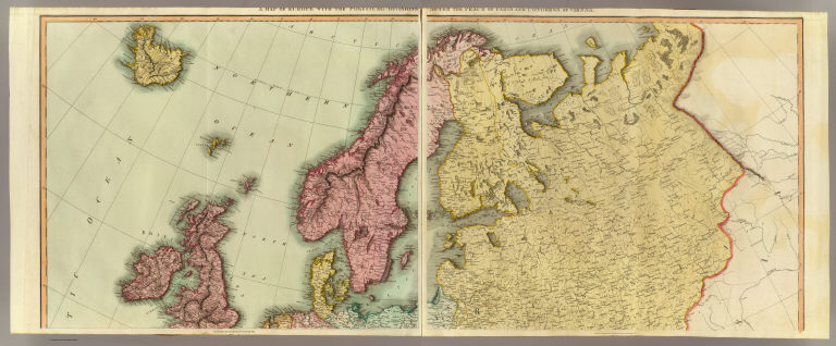
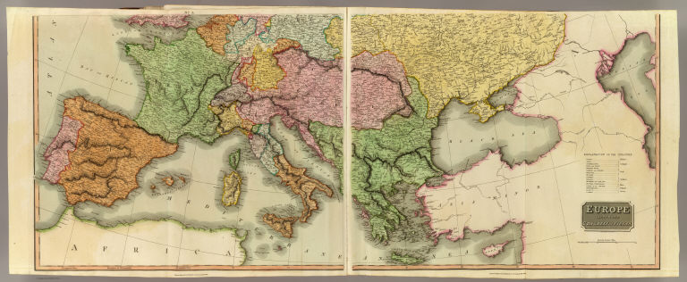
Author
Thomson, John
Full Title
Europe after the Congress of Vienna. Neele sculpt., 352 Strand, London. Drawn & engraved for Thomson's New general atlas, 1816.
List No
1007.036
Note
Two engraved maps. Hand colored. Sheets 3 and 4 (or the southern half). Sheets 1-2 have title in upper margins: A map of Europe with the political divisions after the Peace of Paris and Congress of Vienna. Relief shown by hachures.
Author
Thomson, John
Full Title
Asia. J. & G. Menzies sculpt. (Drawn & engraved for Thomson's New general atlas, 1817)
List No
1007.038
Note
Engraved map. Hand colored. Relief shown pictorially.
Author
Thomson, John
Full Title
Russian Empire. N.R. Hewitt Sc., 10 Broad Str., Bloomsby., London. Drawn & engraved for John Thomson & Co.'s New general atlas, 12 August 1814.
List No
1007.039
Note
Engraved map. Outline hand color. Relief shown by hachures.
Author
Thomson, John
Full Title
Tartary. N.R. Hewitt sc., 10 Broad Str., Bloomsbry., London. Drawn and engraved for Thomson's New general atlas, Sepr. 1st., 1814.
List No
1007.040
Note
Engraved map. Outline hand color. Relief shown by hachures.
Author
Thomson, John
Full Title
Corea and Japan. J. & G. Menzies sculpt., Edinr. Drawn & engraved for Thomson's New general atlas, 16th. Augt. 1815.
List No
1007.041
Note
Engraved map. Hand colored. Relief shown by hachures.
Author
Thomson, John
Full Title
China. R. Scott sculpt., Edinr. Drawn & engraved for Thomson's New general atlas. Edinburgh 1815.
List No
1007.042
Note
Engraved map. Hand colored. Relief shown by hachures. Shows "Tract of the Hindoostan & Lion with the British Embassy to China 1793."
Author
Thomson, John
Full Title
East India Isles. T. Clerk sculpt., Edinr. (Drawn & engraved for Thomson's New general atlas, 1817)
List No
1007.043
Note
Engraved map. Hand colored. Relief shown pictorially.
Author
[J. & G. Menzies, Thomson, John]
Full Title
Hindoostan. (with) Isle of Ceylon. J. & G. Menzies sculpt., Edinr. (Drawn & engraved for Thomson's New general atlas, 1817)
List No
1007.044
Note
Engraved map with inset. Hand colored. Relief shown by hachures.
|