|
REFINE
Browse All : Atlas Map and State Atlas of Nova Scotia
1-44 of 44
Author
Roe Brothers (Firm)
Full Title
Geological map of the Maritime Provinces of the Dominion of Canada. (with) Newfoundland. (Drawn on the Rectangular polyconic projection. Drawn and published by Roe Brothers, (A.D. & W.B. Roe). Eng. by Worley & Bracher, Philada. Printed by F. Bourquin, Philada. 1878)
List No
0859.001
Note
Hand colored map. Shows 9 geologic units, settlements, railroads, etc.
Author
Roe Brothers (Firm)
Full Title
Map of the Maritime Provinces of the Dominion of Canada. (with) Newfoundland. (Drawn on the Rectangular polyconic projection. Drawn and published by Roe Brothers, (A.D. & W.B. Roe). Eng. by Worley & Bracher, Philada. Printed by F. Bourquin, Philada. 1878)
List No
0859.002
Note
Hand colored map. Shows settlements, counties, railroads, etc.
Author
Roe Brothers (Firm)
Full Title
County of Cumberland, Nova Scotia. (Drawn on the Rectangular polyconic projection. Drawn and published by Roe Brothers, (A.D. & W.B. Roe). Eng. by Worley & Bracher, Philada. Printed by F. Bourquin, Philada. 1878)
List No
0859.015
Note
Hand colored map. Relief shown by hachures. Shows administrative subdivisions, settlements, railroads, etc. At head of title: Atlas of the Maritime Provinces.
Author
Roe Brothers (Firm)
Full Title
County of Colchester, Nova Scotia. (Drawn on the Rectangular polyconic projection. Drawn and published by Roe Brothers, (A.D. & W.B. Roe). Eng. by Worley & Bracher, Philada. Printed by F. Bourquin, Philada. 1878)
List No
0859.016
Note
Hand colored map. Relief shown by hachures. Shows administrative subdivisions, settlements, railroads, etc. At head of title: Atlas of the Maritime Provinces.
Author
Roe Brothers (Firm)
Full Title
County of Hants, Nova Scotia. (Drawn on the Rectangular polyconic projection. Drawn and published by Roe Brothers, (A.D. & W.B. Roe). Eng. by Worley & Bracher, Philada. Printed by F. Bourquin, Philada. 1878)
List No
0859.017
Note
Hand colored map. Relief shown by hachures. Shows administrative subdivisions, settlements, railroads, etc. At head of title: Atlas of the Maritime Provinces.
Author
Roe Brothers (Firm)
Full Title
County of Kings, Nova Scotia. (Drawn on the Rectangular polyconic projection. Drawn and published by Roe Brothers, (A.D. & W.B. Roe). Eng. by Worley & Bracher, Philada. Printed by F. Bourquin, Philada. 1878)
List No
0859.018
Note
Hand colored map. Relief shown by hachures. Shows administrative subdivisions, settlements, railroads, etc. At head of title: Atlas of the Maritime Provinces.
Author
Roe Brothers (Firm)
Full Title
County of Lunenburg, Nova Scotia. (Drawn on the Rectangular polyconic projection. Drawn and published by Roe Brothers, (A.D. & W.B. Roe). Eng. by Worley & Bracher, Philada. Printed by F. Bourquin, Philada. 1878)
List No
0859.019
Note
Hand colored map. Relief shown by hachures. Shows administrative subdivisions, settlements, railroads, etc. At head of title: Atlas of the Maritime Provinces.
Author
Roe Brothers (Firm)
Full Title
Counties of Annapolis and Queens, Nova Scotia. (Drawn on the Rectangular polyconic projection. Drawn and published by Roe Brothers, (A.D. & W.B. Roe). Eng. by Worley & Bracher, Philada. Printed by F. Bourquin, Philada. 1878)
List No
0859.020
Note
Hand colored map. Relief shown by hachures. Shows administrative subdivisions, settlements, railroad, etc. At head of title: Atlas of the Maritime Provinces. The name "Nova Scotia" in title is on label pasted on.
Author
Roe Brothers (Firm)
Full Title
Counties of Yarmouth and Shelburne, Nova Scotia. (Drawn on the Rectangular polyconic projection. Drawn and published by Roe Brothers, (A.D. & W.B. Roe). Eng. by Worley & Bracher, Philada. Printed by F. Bourquin, Philada. 1878)
List No
0859.021
Note
Hand colored map. Relief shown by hachures. Shows administrative subdivisions, settlements, railroad, etc. At head of title: Atlas of the Maritime Provinces.
Author
Roe Brothers (Firm)
Full Title
County of Digby, Nova Scotia. (Drawn on the Rectangular polyconic projection. Drawn and published by Roe Brothers, (A.D. & W.B. Roe). Eng. by Worley & Bracher, Philada. Printed by F. Bourquin, Philada. 1878)
List No
0859.022
Note
Hand colored map. Relief shown by hachures. Shows administrative subdivisions, settlements, railroad, etc. At head of title: Atlas of the Maritime Provinces.
Author
Roe Brothers (Firm)
Full Title
County of Halifax, Nova Scotia. (Drawn on the Rectangular polyconic projection. Drawn and published by Roe Brothers, (A.D. & W.B. Roe). Eng. by Worley & Bracher, Philada. Printed by F. Bourquin, Philada. 1878)
List No
0859.023
Note
Hand colored map. Relief shown by hachures. Shows administrative subdivisions, settlements, railroad, etc. At head of title: Atlas of the Maritime Provinces.
Author
Roe Brothers (Firm)
Full Title
County of Pictou, Nova Scotia. (Drawn on the Rectangular polyconic projection. Drawn and published by Roe Brothers, (A.D. & W.B. Roe). Eng. by Worley & Bracher, Philada. Printed by F. Bourquin, Philada. 1878)
List No
0859.024
Note
Hand colored map. Relief shown by hachures. Shows administrative subdivisions, settlements, railroads, etc. At head of title: Atlas of the Maritime Provinces.
Author
Roe Brothers (Firm)
Full Title
Counties of Antigonish and Guysborough, Nova Scotia. (Drawn on the Rectangular polyconic projection. Drawn and published by Roe Brothers, (A.D. & W.B. Roe). Eng. by Worley & Bracher, Philada. Printed by F. Bourquin, Philada. 1878)
List No
0859.025
Note
Hand colored map. Relief shown by hachures. Shows administrative subdivisions, settlements, railroads, etc. At head of title: Atlas of the Maritime Provinces.
Author
Roe Brothers (Firm)
Full Title
Counties of Inverness and Victoria, Nova Scotia. (with) Magdalin (i.e. Magdalen) Islands. (Drawn on the Rectangular polyconic projection. Drawn and published by Roe Brothers, (A.D. & W.B. Roe). Eng. by Worley & Bracher, Philada. Printed by F. Bourquin, Philada. 1878)
List No
0859.026
Note
Hand colored map. Relief shown by hachures. Shows administrative subdivisions, settlements, railroad, etc. At head of title: Atlas of the Maritime Provinces.
Author
Roe Brothers (Firm)
Full Title
Counties of Cape Breton and Richmond, Nova Scotia. (Drawn on the Rectangular polyconic projection. Drawn and published by Roe Brothers, (A.D. & W.B. Roe). Eng. by Worley & Bracher, Philada. Printed by F. Bourquin, Philada. 1878)
List No
0859.027
Note
Hand colored map. Relief shown by hachures. Shows administrative subdivisions, settlements, railroad, etc. At head of title: Atlas of the Maritime Provinces.
Author
Roe Brothers (Firm)
Full Title
Map of the city of Halifax, Halifax Co., N.S. (Drawn on the Rectangular polyconic projection. Drawn and published by Roe Brothers, (A.D. & W.B. Roe). Eng. by Worley & Bracher, Philada. Printed by F. Bourquin, Philada. 1878)
List No
0859.031
Note
Hand colored map. Relief shown by hachures; soundings in fathoms. Shows administrative subdivisions, major buildings, wharves, radial distances from city center, etc.
Author
Mitchell, Samuel Augustus
Full Title
County map of Nova Scotia, New Brunswick, Cape Breton Id. and Pr. Edward's Id. Entered ... 1870 by S. Augustus Mitchell, Jr. ... Pennsylvania.
List No
2483.005
Note
Hand colored. Relief shown by hachures. Inset: City and harbor of Halifax. Shows counties, settlements, railroads, etc. Prime meridians: Greenwich and Washington.
Author
Cummins Map Co.
Full Title
Road Map of the Maritime Provinces. (inset) Prince Edward Island.
List No
3273.062
Note
Date estimated.
Author
Cummins Map Co.
Full Title
Province of Nova Scotia and Prince Edward Island, Canada.
List No
3273.064
Note
Date estimated.
Author
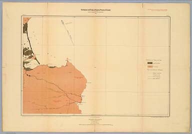
[Fletcher, Hugh., Geological Survey of Canada]
Full Title
Province of Nova Scotia (Island of Cape Breton). Geological and Natural History Survey of Canada. Alfred R.C. Selwyn, LL.D., F.R.S. &c. Director. 1884. The Burland Lith. Company Montreal. Compiled and drawn by Hugh Fletcher, from plans made by the Admiralty, the Department of Crown Lands, Nova Scotia, and the Geological Survey. To illustrate Reports by Hugh Fletcher, 1879 to 1884. Sheet no. 1.
List No
3997.003
Note
Full color. Shows geologic units, mineral deposits, mineral springs, falls, fishing stations, buildings, land holders names, schools, parish and county boundaries, notes, etc. Relief shown by spot heights. The maps index the various geological reports. Rumsey collection maps backed on linen; protected in new blue cloth folding boards with blue cloth slip case 22 x 16.5 cm., stamped with title "Cape Breton, Nova Scotia, Geological Survey of Canada, 1884" on spine in gold.
Author
[Fletcher, Hugh., Geological Survey of Canada]
Full Title
Province of Nova Scotia (Island of Cape Breton). Geological and Natural History Survey of Canada. Alfred R.C. Selwyn, LL.D., F.R.S. &c. Director. 1884. The Burland Lith. Company Montreal. Compiled and drawn by Hugh Fletcher, from plans made by the Admiralty, the Department of Crown Lands, Nova Scotia, and the Geological Survey. To illustrate Reports by Hugh Fletcher, 1879 to 1884. Sheet no. 2.
List No
3997.004
Note
Full color. Shows geologic units, mineral deposits, mineral springs, falls, fishing stations, buildings, land holders names, schools, parish and county boundaries, notes, etc. Relief shown by spot heights. The maps index the various geological reports. Rumsey collection maps backed on linen; protected in new blue cloth folding boards with blue cloth slip case 22 x 16.5 cm., stamped with title "Cape Breton, Nova Scotia, Geological Survey of Canada, 1884" on spine in gold.
Author
[Fletcher, Hugh., Geological Survey of Canada]
Full Title
Province of Nova Scotia (Island of Cape Breton). Geological and Natural History Survey of Canada. Alfred R.C. Selwyn, LL.D., F.R.S. &c. Director. 1884. The Burland Lith. Company Montreal. Compiled and drawn by Hugh Fletcher, from plans made by the Admiralty, the Department of Crown Lands, Nova Scotia, and the Geological Survey. To illustrate Reports by Hugh Fletcher, 1879 to 1884. Sheet no. 3.
List No
3997.005
Note
Full color. Shows geologic units, mineral deposits, mineral springs, falls, fishing stations, buildings, land holders names, schools, parish and county boundaries, notes, etc. Relief shown by spot heights. The maps index the various geological reports. Rumsey collection maps backed on linen; protected in new blue cloth folding boards with blue cloth slip case 22 x 16.5 cm., stamped with title "Cape Breton, Nova Scotia, Geological Survey of Canada, 1884" on spine in gold.
Author
[Fletcher, Hugh., Geological Survey of Canada]
Full Title
Province of Nova Scotia (Island of Cape Breton). Geological and Natural History Survey of Canada. Alfred R.C. Selwyn, LL.D., F.R.S. &c. Director. 1884. The Burland Lith. Company Montreal. Compiled and drawn by Hugh Fletcher, from plans made by the Admiralty, the Department of Crown Lands, Nova Scotia, and the Geological Survey. To illustrate Reports by Hugh Fletcher, 1879 to 1884. Sheet no. 4.
List No
3997.006
Note
Full color. Shows geologic units, mineral deposits, mineral springs, falls, fishing stations, buildings, land holders names, schools, parish and county boundaries, notes, etc. Relief shown by spot heights. The maps index the various geological reports. Rumsey collection maps backed on linen; protected in new blue cloth folding boards with blue cloth slip case 22 x 16.5 cm., stamped with title "Cape Breton, Nova Scotia, Geological Survey of Canada, 1884" on spine in gold.
Author
[Fletcher, Hugh., Geological Survey of Canada]
Full Title
Province of Nova Scotia (Island of Cape Breton). Geological and Natural History Survey of Canada. Alfred R.C. Selwyn, LL.D., F.R.S. &c. Director. 1884. The Burland Lith. Company Montreal. Compiled and drawn by Hugh Fletcher, from plans made by the Admiralty, the Department of Crown Lands, Nova Scotia, and the Geological Survey. To illustrate Reports by Hugh Fletcher, 1879 to 1884. Sheet no. 5.
List No
3997.007
Note
Full color. Shows geologic units, mineral deposits, mineral springs, falls, fishing stations, buildings, land holders names, schools, parish and county boundaries, notes, etc. Relief shown by spot heights. The maps index the various geological reports. Rumsey collection maps backed on linen; protected in new blue cloth folding boards with blue cloth slip case 22 x 16.5 cm., stamped with title "Cape Breton, Nova Scotia, Geological Survey of Canada, 1884" on spine in gold.
Author
[Fletcher, Hugh., Geological Survey of Canada]
Full Title
Province of Nova Scotia (Island of Cape Breton). Geological and Natural History Survey of Canada. Alfred R.C. Selwyn, LL.D., F.R.S. &c. Director. 1884. The Burland Lith. Company Montreal. Compiled and drawn by Hugh Fletcher, from plans made by the Admiralty, the Department of Crown Lands, Nova Scotia, and the Geological Survey. To illustrate Reports by Hugh Fletcher, 1879 to 1884. Sheet no. 6.
List No
3997.008
Note
Full color. Shows geologic units, mineral deposits, mineral springs, falls, fishing stations, buildings, land holders names, schools, parish and county boundaries, notes, etc. Relief shown by spot heights. The maps index the various geological reports. Rumsey collection maps backed on linen; protected in new blue cloth folding boards with blue cloth slip case 22 x 16.5 cm., stamped with title "Cape Breton, Nova Scotia, Geological Survey of Canada, 1884" on spine in gold.
Author
[Fletcher, Hugh., Geological Survey of Canada]
Full Title
Province of Nova Scotia (Island of Cape Breton). Geological and Natural History Survey of Canada. Alfred R.C. Selwyn, LL.D., F.R.S. &c. Director. 1884. The Burland Lith. Company Montreal. Compiled and drawn by Hugh Fletcher, from plans made by the Admiralty, the Department of Crown Lands, Nova Scotia, and the Geological Survey. To illustrate Reports by Hugh Fletcher, 1879 to 1884. Sheet no. 7.
List No
3997.009
Note
Full color. Shows geologic units, mineral deposits, mineral springs, falls, fishing stations, buildings, land holders names, schools, parish and county boundaries, notes, etc. Relief shown by spot heights. The maps index the various geological reports. Rumsey collection maps backed on linen; protected in new blue cloth folding boards with blue cloth slip case 22 x 16.5 cm., stamped with title "Cape Breton, Nova Scotia, Geological Survey of Canada, 1884" on spine in gold.
Author
[Fletcher, Hugh., Geological Survey of Canada]
Full Title
Province of Nova Scotia (Island of Cape Breton). Geological and Natural History Survey of Canada. Alfred R.C. Selwyn, LL.D., F.R.S. &c. Director. 1884. The Burland Lith. Company Montreal. Compiled and drawn by Hugh Fletcher, from plans made by the Admiralty, the Department of Crown Lands, Nova Scotia, and the Geological Survey. To illustrate Reports by Hugh Fletcher, 1879 to 1884. Sheet no. 8.
List No
3997.010
Note
Full color. Shows geologic units, mineral deposits, mineral springs, falls, fishing stations, buildings, land holders names, schools, parish and county boundaries, notes, etc. Relief shown by spot heights. The maps index the various geological reports. Rumsey collection maps backed on linen; protected in new blue cloth folding boards with blue cloth slip case 22 x 16.5 cm., stamped with title "Cape Breton, Nova Scotia, Geological Survey of Canada, 1884" on spine in gold.
Author
[Fletcher, Hugh., Geological Survey of Canada]
Full Title
Province of Nova Scotia (Island of Cape Breton). Geological and Natural History Survey of Canada. Alfred R.C. Selwyn, LL.D., F.R.S. &c. Director. 1884. The Burland Lith. Company Montreal. Compiled and drawn by Hugh Fletcher, from plans made by the Admiralty, the Department of Crown Lands, Nova Scotia, and the Geological Survey. To illustrate Reports by Hugh Fletcher, 1879 to 1884. Sheet no. 9.
List No
3997.011
Note
Full color. Shows geologic units, mineral deposits, mineral springs, falls, fishing stations, buildings, land holders names, schools, parish and county boundaries, notes, etc. Relief shown by spot heights. The maps index the various geological reports. Rumsey collection maps backed on linen; protected in new blue cloth folding boards with blue cloth slip case 22 x 16.5 cm., stamped with title "Cape Breton, Nova Scotia, Geological Survey of Canada, 1884" on spine in gold.
Author
[Fletcher, Hugh., Geological Survey of Canada]
Full Title
Province of Nova Scotia (Island of Cape Breton). Geological and Natural History Survey of Canada. Alfred R.C. Selwyn, LL.D., F.R.S. &c. Director. 1884. The Burland Lith. Company Montreal. Compiled and drawn by Hugh Fletcher, from plans made by the Admiralty, the Department of Crown Lands, Nova Scotia, and the Geological Survey. To illustrate Reports by Hugh Fletcher, 1879 to 1884. Sheet no. 10.
List No
3997.012
Note
Full color. Shows geologic units, mineral deposits, mineral springs, falls, fishing stations, buildings, land holders names, schools, parish and county boundaries, notes, etc. Relief shown by spot heights. The maps index the various geological reports. Rumsey collection maps backed on linen; protected in new blue cloth folding boards with blue cloth slip case 22 x 16.5 cm., stamped with title "Cape Breton, Nova Scotia, Geological Survey of Canada, 1884" on spine in gold.
Author
[Fletcher, Hugh., Geological Survey of Canada]
Full Title
Province of Nova Scotia (Island of Cape Breton). Geological and Natural History Survey of Canada. Alfred R.C. Selwyn, LL.D., F.R.S. &c. Director. 1884. The Burland Lith. Company Montreal. Compiled and drawn by Hugh Fletcher, from plans made by the Admiralty, the Department of Crown Lands, Nova Scotia, and the Geological Survey. To illustrate Reports by Hugh Fletcher, 1879 to 1884. Sheet no. 11.
List No
3997.013
Note
Full color. Shows geologic units, mineral deposits, mineral springs, falls, fishing stations, buildings, land holders names, schools, parish and county boundaries, notes, etc. Relief shown by spot heights. The maps index the various geological reports. Rumsey collection maps backed on linen; protected in new blue cloth folding boards with blue cloth slip case 22 x 16.5 cm., stamped with title "Cape Breton, Nova Scotia, Geological Survey of Canada, 1884" on spine in gold.
Author
[Fletcher, Hugh., Geological Survey of Canada]
Full Title
Province of Nova Scotia (Island of Cape Breton). Geological and Natural History Survey of Canada. Alfred R.C. Selwyn, LL.D., F.R.S. &c. Director. 1884. The Burland Lith. Company Montreal. Compiled and drawn by Hugh Fletcher, from plans made by the Admiralty, the Department of Crown Lands, Nova Scotia, and the Geological Survey. To illustrate Reports by Hugh Fletcher, 1879 to 1884. Sheet no. 12.
List No
3997.014
Note
Full color. Shows geologic units, mineral deposits, mineral springs, falls, fishing stations, buildings, land holders names, schools, parish and county boundaries, notes, etc. Relief shown by spot heights. The maps index the various geological reports. Rumsey collection maps backed on linen; protected in new blue cloth folding boards with blue cloth slip case 22 x 16.5 cm., stamped with title "Cape Breton, Nova Scotia, Geological Survey of Canada, 1884" on spine in gold.
Author
[Fletcher, Hugh., Geological Survey of Canada]
Full Title
Province of Nova Scotia (Island of Cape Breton). Geological and Natural History Survey of Canada. Alfred R.C. Selwyn, LL.D., F.R.S. &c. Director. 1884. The Burland Lith. Company Montreal. Compiled and drawn by Hugh Fletcher, from plans made by the Admiralty, the Department of Crown Lands, Nova Scotia, and the Geological Survey. To illustrate Reports by Hugh Fletcher, 1879 to 1884. Sheet no. 13.
List No
3997.015
Note
Full color. Shows geologic units, mineral deposits, mineral springs, falls, fishing stations, buildings, land holders names, schools, parish and county boundaries, notes, etc. Relief shown by spot heights. The maps index the various geological reports. Rumsey collection maps backed on linen; protected in new blue cloth folding boards with blue cloth slip case 22 x 16.5 cm., stamped with title "Cape Breton, Nova Scotia, Geological Survey of Canada, 1884" on spine in gold.
Author
[Fletcher, Hugh., Geological Survey of Canada]
Full Title
Province of Nova Scotia (Island of Cape Breton). Geological and Natural History Survey of Canada. Alfred R.C. Selwyn, LL.D., F.R.S. &c. Director. 1884. The Burland Lith. Company Montreal. Compiled and drawn by Hugh Fletcher, from plans made by the Admiralty, the Department of Crown Lands, Nova Scotia, and the Geological Survey. To illustrate Reports by Hugh Fletcher, 1879 to 1884. Sheet no. 14.
List No
3997.016
Note
Full color. Shows geologic units, mineral deposits, mineral springs, falls, fishing stations, buildings, land holders names, schools, parish and county boundaries, notes, etc. Relief shown by spot heights. The maps index the various geological reports. Rumsey collection maps backed on linen; protected in new blue cloth folding boards with blue cloth slip case 22 x 16.5 cm., stamped with title "Cape Breton, Nova Scotia, Geological Survey of Canada, 1884" on spine in gold.
Author
[Fletcher, Hugh., Geological Survey of Canada]
Full Title
Province of Nova Scotia (Island of Cape Breton). Geological and Natural History Survey of Canada. Alfred R.C. Selwyn, LL.D., F.R.S. &c. Director. 1884. The Burland Lith. Company Montreal. Compiled and drawn by Hugh Fletcher, from plans made by the Admiralty, the Department of Crown Lands, Nova Scotia, and the Geological Survey. To illustrate Reports by Hugh Fletcher, 1879 to 1884. Sheet no. 15.
List No
3997.017
Note
Full color. Shows geologic units, mineral deposits, mineral springs, falls, fishing stations, buildings, land holders names, schools, parish and county boundaries, notes, etc. Relief shown by spot heights. The maps index the various geological reports. Rumsey collection maps backed on linen; protected in new blue cloth folding boards with blue cloth slip case 22 x 16.5 cm., stamped with title "Cape Breton, Nova Scotia, Geological Survey of Canada, 1884" on spine in gold.
Author
[Fletcher, Hugh., Geological Survey of Canada]
Full Title
Province of Nova Scotia (Island of Cape Breton). Geological and Natural History Survey of Canada. Alfred R.C. Selwyn, LL.D., F.R.S. &c. Director. 1884. The Burland Lith. Company Montreal. Compiled and drawn by Hugh Fletcher, from plans made by the Admiralty, the Department of Crown Lands, Nova Scotia, and the Geological Survey. To illustrate Reports by Hugh Fletcher, 1879 to 1884. Sheet no. 16.
List No
3997.018
Note
Full color. Shows geologic units, mineral deposits, mineral springs, falls, fishing stations, buildings, land holders names, schools, parish and county boundaries, notes, etc. Relief shown by spot heights. The maps index the various geological reports. Rumsey collection maps backed on linen; protected in new blue cloth folding boards with blue cloth slip case 22 x 16.5 cm., stamped with title "Cape Breton, Nova Scotia, Geological Survey of Canada, 1884" on spine in gold.
Author
[Fletcher, Hugh., Geological Survey of Canada]
Full Title
Province of Nova Scotia (Island of Cape Breton). Geological and Natural History Survey of Canada. Alfred R.C. Selwyn, LL.D., F.R.S. &c. Director. 1884. The Burland Lith. Company Montreal. Compiled and drawn by Hugh Fletcher, from plans made by the Admiralty, the Department of Crown Lands, Nova Scotia, and the Geological Survey. To illustrate Reports by Hugh Fletcher, 1879 to 1884. Sheet no. 17.
List No
3997.019
Note
Full color. Shows geologic units, mineral deposits, mineral springs, falls, fishing stations, buildings, land holders names, schools, parish and county boundaries, notes, etc. Relief shown by spot heights. The maps index the various geological reports. Rumsey collection maps backed on linen; protected in new blue cloth folding boards with blue cloth slip case 22 x 16.5 cm., stamped with title "Cape Breton, Nova Scotia, Geological Survey of Canada, 1884" on spine in gold.
Author
[Fletcher, Hugh., Geological Survey of Canada]
Full Title
Province of Nova Scotia (Island of Cape Breton). Geological and Natural History Survey of Canada. Alfred R.C. Selwyn, LL.D., F.R.S. &c. Director. 1884. The Burland Lith. Company Montreal. Compiled and drawn by Hugh Fletcher, from plans made by the Admiralty, the Department of Crown Lands, Nova Scotia, and the Geological Survey. To illustrate Reports by Hugh Fletcher, 1879 to 1884. Sheet no. 18.
List No
3997.020
Note
Full color. Shows geologic units, mineral deposits, mineral springs, falls, fishing stations, buildings, land holders names, schools, parish and county boundaries, notes, etc. Relief shown by spot heights. The maps index the various geological reports. Rumsey collection maps backed on linen; protected in new blue cloth folding boards with blue cloth slip case 22 x 16.5 cm., stamped with title "Cape Breton, Nova Scotia, Geological Survey of Canada, 1884" on spine in gold.
Author
[Fletcher, Hugh., Geological Survey of Canada]
Full Title
Province of Nova Scotia (Island of Cape Breton). Geological and Natural History Survey of Canada. Alfred R.C. Selwyn, LL.D., F.R.S. &c. Director. 1884. The Burland Lith. Company Montreal. Compiled and drawn by Hugh Fletcher, from plans made by the Admiralty, the Department of Crown Lands, Nova Scotia, and the Geological Survey. To illustrate Reports by Hugh Fletcher, 1879 to 1884. Sheet no. 19.
List No
3997.021
Note
Full color. Shows geologic units, mineral deposits, mineral springs, falls, fishing stations, buildings, land holders names, schools, parish and county boundaries, notes, etc. Relief shown by spot heights. The maps index the various geological reports. Rumsey collection maps backed on linen; protected in new blue cloth folding boards with blue cloth slip case 22 x 16.5 cm., stamped with title "Cape Breton, Nova Scotia, Geological Survey of Canada, 1884" on spine in gold.
Author
[Fletcher, Hugh., Geological Survey of Canada]
Full Title
Province of Nova Scotia (Island of Cape Breton). Geological and Natural History Survey of Canada. Alfred R.C. Selwyn, LL.D., F.R.S. &c. Director. 1884. The Burland Lith. Company Montreal. Compiled and drawn by Hugh Fletcher, from plans made by the Admiralty, the Department of Crown Lands, Nova Scotia, and the Geological Survey. To illustrate Reports by Hugh Fletcher, 1879 to 1884. Sheet no. 20.
List No
3997.022
Note
Full color. Shows geologic units, mineral deposits, mineral springs, falls, fishing stations, buildings, land holders names, schools, parish and county boundaries, notes, etc. Relief shown by spot heights. The maps index the various geological reports. Rumsey collection maps backed on linen; protected in new blue cloth folding boards with blue cloth slip case 22 x 16.5 cm., stamped with title "Cape Breton, Nova Scotia, Geological Survey of Canada, 1884" on spine in gold.
Author
[Fletcher, Hugh., Geological Survey of Canada]
Full Title
Province of Nova Scotia (Island of Cape Breton). Geological and Natural History Survey of Canada. Alfred R.C. Selwyn, LL.D., F.R.S. &c. Director. 1884. The Burland Lith. Company Montreal. Compiled and drawn by Hugh Fletcher, from plans made by the Admiralty, the Department of Crown Lands, Nova Scotia, and the Geological Survey. To illustrate Reports by Hugh Fletcher, 1879 to 1884. Sheet no. 21.
List No
3997.023
Note
Full color. Shows geologic units, mineral deposits, mineral springs, falls, fishing stations, buildings, land holders names, schools, parish and county boundaries, notes, etc. Relief shown by spot heights. The maps index the various geological reports. Rumsey collection maps backed on linen; protected in new blue cloth folding boards with blue cloth slip case 22 x 16.5 cm., stamped with title "Cape Breton, Nova Scotia, Geological Survey of Canada, 1884" on spine in gold.
Author
[Fletcher, Hugh., Geological Survey of Canada]
Full Title
Province of Nova Scotia (Island of Cape Breton). Geological and Natural History Survey of Canada. Alfred R.C. Selwyn, LL.D., F.R.S. &c. Director. 1884. The Burland Lith. Company Montreal. Compiled and drawn by Hugh Fletcher, from plans made by the Admiralty, the Department of Crown Lands, Nova Scotia, and the Geological Survey. To illustrate Reports by Hugh Fletcher, 1879 to 1884. Sheet no. 22.
List No
3997.024
Note
Full color. Shows geologic units, mineral deposits, mineral springs, falls, fishing stations, buildings, land holders names, schools, parish and county boundaries, notes, etc. Relief shown by spot heights. The maps index the various geological reports. Rumsey collection maps backed on linen; protected in new blue cloth folding boards with blue cloth slip case 22 x 16.5 cm., stamped with title "Cape Breton, Nova Scotia, Geological Survey of Canada, 1884" on spine in gold.
Author
[Fletcher, Hugh., Geological Survey of Canada]
Full Title
Province of Nova Scotia (Island of Cape Breton). Geological and Natural History Survey of Canada. Alfred R.C. Selwyn, LL.D., F.R.S. &c. Director. 1884. The Burland Lith. Company Montreal. Compiled and drawn by Hugh Fletcher, from plans made by the Admiralty, the Department of Crown Lands, Nova Scotia, and the Geological Survey. To illustrate Reports by Hugh Fletcher, 1879 to 1884. Sheet no. 23.
List No
3997.025
Note
Full color. Shows geologic units, mineral deposits, mineral springs, falls, fishing stations, buildings, land holders names, schools, parish and county boundaries, notes, etc. Relief shown by spot heights. The maps index the various geological reports. Rumsey collection maps backed on linen; protected in new blue cloth folding boards with blue cloth slip case 22 x 16.5 cm., stamped with title "Cape Breton, Nova Scotia, Geological Survey of Canada, 1884" on spine in gold.
Author
[Fletcher, Hugh., Geological Survey of Canada]
Full Title
Province of Nova Scotia (Island of Cape Breton). Geological and Natural History Survey of Canada. Alfred R.C. Selwyn, LL.D., F.R.S. &c. Director. 1884. The Burland Lith. Company Montreal. Compiled and drawn by Hugh Fletcher, from plans made by the Admiralty, the Department of Crown Lands, Nova Scotia, and the Geological Survey. To illustrate Reports by Hugh Fletcher, 1879 to 1884. Sheet no. 24.
List No
3997.026
Note
Full color. Shows geologic units, mineral deposits, mineral springs, falls, fishing stations, buildings, land holders names, schools, parish and county boundaries, notes, etc. Relief shown by spot heights. The maps index the various geological reports. Rumsey collection maps backed on linen; protected in new blue cloth folding boards with blue cloth slip case 22 x 16.5 cm., stamped with title "Cape Breton, Nova Scotia, Geological Survey of Canada, 1884" on spine in gold.
Author
[Meacham, J.H. & Co., Allen, C.R.]
Full Title
Dominion of Canada (Eastern Sheet).
List No
4475.009
1-44 of 44
|