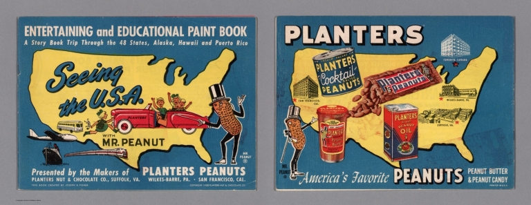
|
Author
[Fisher, Joseph R., Planters Peanuts (Firm)]
Full Title
(Covers to) Seeing the U.S.A. with Mr. Peanut : A story book trip through the 48 states, Alaska, Hawaii and Puerto Rico / presented by the makers of Planters Peanuts, Planters Nuts & Chocolate Co., Suffolk, Va. Wilkes-Barre, Pa. San Francisco, Cal. This book created by Joseph R. Fisher. Printed in U.S.A.
List No
14374.001
Note
Covers to Seeing the U.S.A. with Mr. Peanut. Bound in paper with a pictorial map of the United States on both the front and back covers, printed in color. Places of publication - Suffolk, Va., Wilkes-Barre, Pa. and San Francisco, Ca. highlighted on map. With illustrations of the character Mr. Peanut, as well as modes of transportation: car, bus, train, plane and ship. "Entertaining and educational paint book". Each cover is 20 x 27 cm, unfolded to 20 x 54 cm.
Author
[Fisher, Joseph R., Planters Peanuts (Firm)]
Full Title
(Text Page to) Mr. Peanut presents this paint book for your pleasure. Planters Nuts & Chocolate Co., Wilkes-Barre, Pa. Suffolk, Va. San Francisco, Calif. Toronto, Canada.
List No
14374.002
Note
Introductory text to Seeing the U.S.A. with Mr. Peanut, on verso of front cover. Text begins: Mr. Peanut is proud to bring you the story of the U.S.A. Rich farms, busy factories, abundant minerals... all have helped to make and keep America great. In this his latest paint book, Mr. Peanut takes you on a make-believe trip through the United States. With a map of the United States. Includes a table providing "Coloring hints".
Author
Geological Survey (U.S.)
Full Title
The fifty states.
List No
14359.009
Note
World map highlighting the United States, as of 1970. Shows political boundaries, including those representing Alaska and Hawaii. With distances marked between Washington D. C. and San Francisco, Honolulu and Fairbanks. Colored lithograph. Map is 42 x 32 cm, on sheet 49 x 35 cm. Appears in General reference maps section.
Author
Geological Survey (U.S.)
Full Title
United States general reference. Compiled by U. S. Geological Survey.
List No
14359.010
Note
Map representing the United States, as of 1970. Shows political boundaries, cities, railways, roads, ferry lines, topography, deserts, swamps, bodies of water, drainage, coastlines and islands. Relief shown with shading and peak heights. Features population density for each city. Includes latitudinal and longitudinal lines, a legend, bar scale and scale statement. Presented with Albers Equal Area Projection. With two inset maps: Principal islands of Hawaii -- Alaska. Colored lithograph. Map is 43 x 66 cm, on double sheet 49 x 71 cm. Appears in General reference maps section.
Author
[Geological Survey (U.S.), Harrison, Richard Edes]
Full Title
Perspective views : Outlying areas : Pacific Area / Richard Edes Harrison -- Caribbean Area / Richard Edes Harrison.
List No
14359.011
Note
Two maps representing the Pacific and Caribbean areas, in relation to the United States, as of 1970. Maps show topography, bodies of water, drainage, coastlines and islands. Relief shown pictorially and with color coding. Maps include latitudinal and longitudinal lines. Colored lithograph. Maps are each 20 x 31 cm, on sheet 49 x 35 cm. Maps appear in General reference maps section.
Author
[Geological Survey (U.S.), Harrison, Richard Edes]
Full Title
Shaded relief / Richard Edes Harrison, 1969.
List No
14359.041
Note
Physical map representing the United States, featuring relief, as of 1969. Shows topography, bodies of water, drainage, coastlines and islands. Relief shown with color coding. Includes a legend, latitudinal and longitudinal lines, as well as a bar scale and scale statement. With two inset maps: Principal islands of Hawaii -- Alaska. Presented with Albers Equal Area Projection. Colored lithograph. Map is 43 x 66 cm, on double sheet 49 x 71 cm. Accompanying descriptive text on page 55. Appears in Special subject maps section, subsection Physical : Landforms.
Author
[Geological Survey (U.S.), Hammond, Edwin H.]
Full Title
Classes of land-surface form / adapted from Edwin H. Hammond, "Classes of land surface form in the forty-eight states, U. S.A.," Annals of the Assoc. of Am. Geographers, V. 54, no. 1, 1964, map supp. no. 4, 1:5,000,000.
List No
14359.045
Note
Physical map representing the United States, featuring different land surfaces, such as plains and mountains, as of 1964. Shows political boundaries, topography, bodies of water, drainage, coastlines and islands. Relief shown with color coding. Includes a legend, latitudinal and longitudinal lines, as well as a bar scale and scale statement. With two inset maps: Principal islands of Hawaii -- Alaska. Presented with Albers Equal Area Projection. Colored lithograph. Map is 43 x 66 cm, on double sheet 49 x 71 cm. Accompanying descriptive text on page 55. Appears in Special subject maps section, subsection Physical : Landforms.
Author
[Geological Survey (U.S.), U.S. Coast and Geodetic Survey, United States. Environmental Science Services Administration]
Full Title
Major recorded earthquakes / compiled by U. S. Geological Survey from 1965 data provided by U. S. Coast and Geodetic Survey, Environmental Science Services Administration.
List No
14359.048
Note
Physical map representing the United States, featuring major earthquakes according to intensity, as of 1965. Shows political boundaries, topography, bodies of water, drainage, coastlines and islands. Relief shown with shading. Includes a legend, latitudinal and longitudinal lines, as well as a bar scale and scale statement. With five inset maps: Inset 1 -- Inset 2 -- Inset 3 -- Principal islands of Hawaii -- Alaska. Presented with Albers Equal Area Projection. Colored lithograph. Map is 43 x 66 cm, on double sheet 49 x 71 cm. Accompanying descriptive text on page 55. Appears in Special subject maps section, subsection Physical : Geophysical forces.
Author
[Geological Survey (U.S.), Dolan, Robert, Bosserman, Kenton, Felder, Wilson]
Full Title
Coastal landforms / compiled by Robert Dolan, University of Virginia, assisted by Kenton Bosserman and Wilson Felder, 1967.
List No
14359.057
Note
Physical map representing the United States, featuring coastal landforms, as of 1967. Shows coastline configuration and composition, shoreline characteristics, political boundaries, topography, bodies of water, drainage, coastlines, islands and bathymetry. Relief shown with shading. Includes a legend, latitudinal and longitudinal lines, as well as a bar scale and scale statement. With six inset maps: 1. Sandy Hook to Cape Ann -- 2. Chesapeake Bay and vicinity -- 3. San Francisco Bay Area -- 4. Puget Sound and vicinity -- Principal islands of Hawaii -- Alaska. Presented with Albers Equal Area Projection. Colored lithograph. Map is 43 x 66 cm, on double sheet 49 x 71 cm. Appears in Special subject maps section, subsection Physical : Marine features.
Author
[Geological Survey (U.S.), United States. Naval Oceanographic Office]
Full Title
Sea temperature and salinity / compiled from information provided by U. S. Naval Oceanographic Office, 1968.
List No
14359.060
Note
Sixteen physical maps representing the United States, featuring ocean temperature and salinity, as of 1968. Maps show maximum, minimum and mean temperature in all four seasons, sea surface salinity, political boundaries, bodies of water, coastlines and islands. Maps include legends, as well as bar scales and scale statements. With two inset maps within each map: Principal islands of Hawaii -- Alaska. Colored lithograph. Maps are each 10 x 16 cm, on double sheet 49 x 71 cm. Accompanying descriptive text on page 80. Maps appear in Special subject maps section, subsection Physical : Marine features.
Author
[Geological Survey (U.S.), Küchler, A. W. (August William), 1907-1999]
Full Title
Potential natural vegetation / A. W. Küchler, University of Kansas, 1966.
List No
14359.066
Note
Physical map representing the United States, featuring vegetation, as of 1966. Shows soil vegetation (such as forests and grasslands), political boundaries, bodies of water, drainage, coastlines and islands. Includes legends, latitudinal and longitudinal lines, as well as a bar scale and scale statement. Presented with Albers Equal Area Projection. Colored lithograph. Map is 43 x 66 cm, on double sheet 49 x 71 cm. Accompanying descriptive text on page 89. Appears in Special subject maps section, subsection Physical : Soils.
Author
[Geological Survey (U.S.), United States. Environmental Data Service, United States. Environmental Science Services Administration]
Full Title
Mean monthly sunshine / prepared by U. S. Geological Survey in 1965 from Environmental Data Service, Environmental Science Services Administration records for the period 1931-1960 -- January -- February -- March -- April -- May -- June -- July -- August -- September -- October -- November -- December -- January / adapted from 1:30,000,000-scale maps by Environmental Data Service, Environmental Science Services Administration for the period 1931-1960.
List No
14359.069
Note
Thirteen physical maps representing the United States, featuring the monthly mean for sunshine, as well as monthly sunshine for each month of the year, based upon the period from 1931 to 1960. Maps also show political boundaries, bodies of water, drainage, coastlines and islands. Maps include a legend, as well as a bar scale and scale statements (scales differ). Presented with Albers Equal Area Projection. With two inset maps within each map: Principal islands of Hawaii -- Alaska. Colored lithograph. Together, maps are 42 x 65 cm, on double sheet 49 x 71 cm. Maps appear in Special subject maps section, subsection Physical : Climate.
Author
[Geological Survey (U.S.), United States. Environmental Data Service, United States. Environmental Science Services Administration]
Full Title
Monthly precipitation means and extremes / prepared by U. S. Geological Survey in 1965 from Environmental Data Service, Environmental Science Services Administration records for the period 1931-1960 -- January -- February -- March -- April -- May -- June -- July -- August -- September -- October -- November -- December -- January / adapted from 1:5,000,000-scale maps by Environmental Data Service, Environmental Science Services Administration for the period 1931-1960.
List No
14359.072
Note
Thirteen physical maps representing the United States, featuring the monthly mean for precipitation, as well as monthly precipitation for each month of the year, based upon the period from 1931 to 1960. Maps also show political boundaries, bodies of water, drainage, coastlines and islands. Maps include a legend, as well as a bar scale and scale statements (scales differ). Presented with Albers Equal Area Projection. With two inset maps within each map: Principal islands of Hawaii -- Alaska. Colored lithograph. Together, maps are 42 x 65 cm, on double sheet 49 x 71 cm. Maps appear in Special subject maps section, subsection Physical : Climate.
Author
[Geological Survey (U.S.), United States. Environmental Data Service, United States. Environmental Science Services Administration]
Full Title
Mean annual cooling degree-days, based on data for the period 1931-1960 -- Mean annual heating degree-days, based on data for the period 1931-1960 / adapted from 1:20,000,000-scale maps by Environmental Data Service, Environmental Science Services Administration.
List No
14359.079
Note
Two physical maps representing the United States, featuring mean annual cooling and heating degree days, based upon the period from 1931 to 1960. Maps also show political boundaries, bodies of water, drainage, coastlines and islands. Maps include legends, as well as bar scales and scale statements. Presented with Albers Equal Area Projection. With two inset maps within each map: Principal islands of Hawaii -- Alaska. Colored lithograph. Together, maps are 42 x 31 cm, on sheet 49 x 35 cm. Maps appear in Special subject maps section, subsection Physical : Climate.
Author
[Geological Survey (U.S.), Sturtevant, William C.]
Full Title
Early Indian tribes, culture areas, and linguistic stocks / William C. Sturtevant, Smithsonian Institution, 1967.
List No
14359.094
Note
Historical map representing the United States, featuring the territories and cultural areas and languages of early indigenous peoples, as of around 1899. Shows both major and minor tribes, political boundaries (present-day), bodies of water, drainage, coastlines and islands. Includes a legend, latitudinal and longitudinal lines, as well as a bar scale and scale statement. Presented with Albers Equal Area Projection. With two inset maps: Principal islands of Hawaii -- Alaska. Colored lithograph. Map is 43 x 66 cm, on double sheet 49 x 71 cm. Also, with bibliography for further reading. Accompanying descriptive text on page 132. Appears in Special subject maps section, subsection History.
Author
[Geological Survey (U.S.), Goetzmann, William H.]
Full Title
Exploration and settlement : 1850-1890 / compiled from information provided by William H. Goetzmann, Univertsity of Texas, 1966.
List No
14359.102
Note
Historical map representing the United States, featuring voyages of exploration and settlement from 1850 to 1890. Maps show the routes of explorers, settlements (including both colonial and indigenous), forts, railways, roads, trails, canals, mines, the extent of colonized area, topography, bodies of water, coastlines and islands. Relief shown with shading. Includes legends, as well as a bar scale and scale statement. With inset map: Alaska. Colored lithograph. Map is 20 x 30 cm, on sheet 49 x 35 cm. Accompanied by descriptive text, with references. Appears in Special subject maps section, subsection History.
Author
[Geological Survey (U.S.), Stoll, H. George, Hammond Incorporated]
Full Title
Territorial growth : 1775 -- 1790 -- 1800 -- 1810 -- 1820 -- 1830 -- 1840 -- 1850 -- 1860 -- 1870 -- 1880 -- 1900 -- 1920 -- United States and outlying areas : 1970 / compiled by H. George Stoll, Hammond Incorporated, 1967; rev. by U. S. Geological Survey, 1970.
List No
14359.103
Note
Fourteen historical maps representing the United States, featuring territorial expansion from 1775 - the time of the original thirteen colonies - to 1970, including territories beyond the continental. Maps show political boundaries, bodies of water, drainage, coastlines and islands. Maps include legends, as well as explanatory notes and a scale statement (scales differ). With an inset map within the maps dated 1870, 1880, 1900 and 1920: Alaska. Colored lithograph. Together, maps are 42 x 65 cm, on double sheet 49 x 71 cm. Maps appear in Special subject maps section, subsection History.
Author
[Geological Survey (U.S.), Hammond Incorporated]
Full Title
Presidential elections and political parties : 1796 -- 1800 -- 1804 -- 1808 -- 1812 -- 1816 -- 1820 -- 1824 -- 1828 -- 1832 -- 1836 -- 1840 -- 1844 -- 1848 -- 1852 -- 1856 -- 1860 -- 1864 -- 1868 -- 1872 -- 1876 -- 1880 -- 1884 -- 1888 -- 1892 -- 1896 -- 1900 -- 1904 -- 1908 -- 1912 -- 1916 -- 1920 -- 1924 -- 1928 -- 1932 -- 1936 -- 1940 -- 1944 -- 1948 -- 1952 -- 1956 -- 1960 -- 1964 -- 1968 / compiled by Hammond Incorporated, 1969.
List No
14359.105
Note
Forty-four historical maps representing the United States, featuring presidential elections and political parties from 1796 to 1968. Maps show political boundaries, bodies of water, coastlines and islands. Maps include legends and pie charts, as well as a scale statement. With two inset maps within the maps dated 1960, 1964, and 1968: Hawaii -- Alaska. Also, with a timeline of presidents, from Washington to Nixon. Colored lithograph. Together, maps are 42 x 65 cm, on double sheet 49 x 71 cm. Accompanying descriptive text on page 129. Maps appear in Special subject maps section, subsection History.
Author
[Geological Survey (U.S.), United States. Department of Agriculture, United States. Soil Conservation Service, United States. Department of Agriculture. Economic Research Service, United States. Farmers Home Administration]
Full Title
Soil conservation service programs by farm production regions : 1966 / compiled from information provided by U. S. Soil Conservation Service, 1967 -- Conservation payments by farm production regions : 1966 / compiled from Economic Research Service, Farm income situation, FIS-205, Washingon, U. S. Dept. of Agric., 1967, table 10 -- Commodity credit corporation loans : cumulative 1933-1965 / compiled from U. S. Dept. of Agriculture, Agriculture statistics: 1966, Washington, U. S. Govt. Print. Off., 1966, table 748 -- Payments for selected programs by farm production regions : 1966 / compiled from Economic Research Service, Farm income situation, FIS-205, Washingon, U. S. Dept. of Agric., 1967, table 10 -- Farmers home administration and rural electrification administration loans by farm production regions : 1966 / compiled from U. S. Dept. of Agriculture, Agriculture statistics: 1966, Washington, U. S. Govt. Print. Off., 1966, tables 740 and 741; and information provided by Farmers Home Administration, 1968.
List No
14359.124
Note
Five economic maps representing the United States, featuring agricultural conservation programs, payments and loans, as of 1966. Maps also show political boundaries, bodies of water, coastlines and islands. Maps include legends, as well as bar scales and scale statements (scales differ). Presented with Albers Equal Area Projection. With two inset maps within each map: Principal islands of Hawaii -- Alaska. Colored lithograph. Together, maps are 42 x 31 cm, on sheet 49 x 35 cm. Maps appear in Special subject maps section, subsection Economic : Agriculture.
Author
Geological Survey (U.S.)
Full Title
Oil production and reserves : 1966 -- Natural gas production and reserves : 1966 -- Natural gas liquids production and reserves : 1966 -- Coal production and reserves, anthracite, bituminous, and lignite : 1966 / compiled by U. S. Geologic Survey, 1968 -- Oil shale and tar sands : 1965 -- Nuclear materials : 1967 -- Organic fuels, production and consumption : Total petroleum production, billion barrels of crude oil equivalent -- Oil production, billion barrels -- Gas production, trillion cubic feet -- Coal production, million short tons -- Oil consumption -- Gas consumption -- Coal consumption.
List No
14359.136
Note
Six mineral maps and seven charts representing the United States, featuring the geographic locations of energy materials - such as oil, natural gas and coal - as of 1967. Maps show the production and reserves of energy materials, as well as political boundaries, bodies of water, coastlines and islands. Maps include legends, as well as bar scales and scale statements. Presented with Albers Equal Area Projection. With two inset maps within each map: Principal islands of Hawaii -- Alaska. Charts show production and consumption. Colored lithograph. Together, maps and charts are 42 x 31 cm, on sheet 49 x 35 cm. Accompanying descriptive text on page 177. Maps and charts appear in Special subject maps section, subsection Economic : Mineral and energy resources.
Author
[Geological Survey (U.S.), United States. Federal Power Commission]
Full Title
Electric energy production : 1966 / compiled from Federal Power Commission, Electric power statistics, monthly repts., Washington, U. S. Govt. Print. Off., 1966, tables 1, 2, and 9 -- Electric energy consumption : 1966.
List No
14359.139
Note
Two mineral maps representing the United States, featuring the geographic locations of electric energy production and consumption, as of 1966. Maps also show political boundaries, bodies of water, coastlines and islands. Maps include legends, as well as bar scales and scale statements. Presented with Albers Equal Area Projection. With two inset maps within each map: Principal islands of Hawaii -- Alaska. Colored lithograph. Maps are each 20 x 31 cm, on sheet 49 x 35 cm. Accompanying descriptive text on page 177. Maps appear in Special subject maps section, subsection Economic : Mineral and energy resources.
Author
[Geological Survey (U.S.), U.S. Census Bureau]
Full Title
Wholesale trade : 1963 / adapted from U. S. Bureau of the Census, Retail trade in the United States: 1963, GE-50, no. 20, Washington, U. S. Govt. Print Off., 1963, map 1:5,000,000.
List No
14359.170
Note
Business map representing the United States, featuring the geographic locations of wholesale trade, showing total sales in dollars, as well as the percentage of change in sales from 1958 to 1963. Map also shows political boundaries, bodies of water, drainage, coastlines and islands. Includes a legend, as well as a bar scale and scale statement. Presented with Albers Equal Area Projection. With three inset maps: Massachusetts, Connecticut & Rhode Island -- Principal islands of Hawaii -- Alaska. Colored lithograph. Map is 43 x 66 cm, on double sheet 49 x 71 cm. Appears in Special subject maps section, subsection Economic : Business.
Author
[Geological Survey (U.S.), United States. Federal Aviation Administration]
Full Title
Air flights and facilities : 1965 / compiled from data provided by the Federal Aviation Administration.
List No
14359.175
Note
Transportation map representing the United States, featuring the geographic locations of airports and flight routes, as of 1965. Map also shows political boundaries, time zones, bodies of water, drainage, coastlines and islands. Includes a legend, as well as a bar scale and scale statement. Presented with Albers Equal Area Projection. With two inset maps: Principal islands of Hawaii -- Alaska. Colored lithograph. Map is 43 x 66 cm, on double sheet 49 x 71 cm. Appears in Special subject maps section, subsection Economic : Transportation.
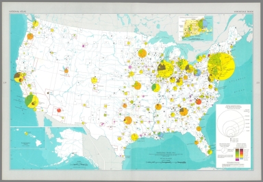
Author
[Geological Survey (U.S.), U.S. Census Bureau]
Full Title
Selected population characteristics / compiled from U. S. Bureau of the Census, Census of population: 1960, v. 1, pt. A, Washington, U. S. Govt. Print Off., 1961 -- Population density : 1960.
List No
14359.180
Note
Chart and statistical map representing the United States, featuring the geographic density of population, including for major cities, as of 1960. Map also shows political boundaries, bodies of water, coastlines and islands. Includes a legend, as well as a bar scale and scale statement. Presented with Albers Equal Area Projection. With two inset maps: Principal islands of Hawaii -- Alaska. Chart shows populations for cities, including the change in population from 1950 to 1960. Colored lithograph. Map and chart are each 20 x 31 cm, on sheet 49 x 35 cm. Map and chart appear in Special subject maps section, subsection Socio-Cultural.
Author
[Geological Survey (U.S.), U.S. Census Bureau]
Full Title
American Indian population : 1960 / adapted from U. S. Bureau of the Census, American Indians in the United States: 1960, GE-50, no. 14, Washington, U. S. Govt. Print Off., 1967, map 1:5,000,000.
List No
14359.193
Note
Statistical map representing the United States, featuring the geographic density of the indigenous population, as of 1960. Map also shows political boundaries, bodies of water, drainage, coastlines and islands. Includes a legend, as well as a bar scale and scale statement. Presented with Albers Equal Area Projection. With two inset maps: Principal islands of Hawaii -- Alaska. Colored lithograph. Map is 43 x 66 cm, on double sheet 49 x 71 cm. Appears in Special subject maps section, subsection Socio-Cultural.
Author
[Geological Survey (U.S.), U.S. Census Bureau]
Full Title
Median family income : 1959 / compiled from U. S. Bureau of the Census, County and city data book: 1962, Washington, U. S. Govt. Print Off., 1962, table 2, item 22; Census of population: 1960, PC(S1)-48, Washington, U. S. Govt. Print Off., 1965, table 3.
List No
14359.196
Note
Statistical map representing the United States, featuring the geographic density of population according to the median family income in 1959. Map also shows political boundaries, bodies of water, drainage, coastlines and islands. Includes a legend, as well as a bar scale and scale statement. Presented with Albers Equal Area Projection. With two inset maps: Principal islands of Hawaii -- Alaska. Colored lithograph. Map is 43 x 66 cm, on double sheet 49 x 71 cm. Appears in Special subject maps section, subsection Socio-Cultural.
Author
[Geological Survey (U.S.), Hirt, Howard E., Cohen, Saul B., United States. Office of Education]
Full Title
Institutions of higher education / compiled by Howard E. Hirt, Bridgewater State College and Saul B. Cohen, Clark University, 1964, revised from U. S. Office of Education, Education directory, 1964-1965, Washington, U. S. Govt. Print Off., 1965, pt. 3, p. 211-218.
List No
14359.202
Note
Statistical map representing the United States, featuring the geographic locations of higher education institutions, as of 1965. Map also shows political boundaries, bodies of water, drainage, coastlines and islands. Includes a legend, as well as a bar scale and scale statement. Presented with Albers Equal Area Projection. With twenty-nine inset maps: 1. New York City area -- 1a. New York City -- 2. Pittsburgh -- 3. Baltimore -- 4. Washington -- 5. Trenton -- 6. Philadelphia -- 7. Nashville -- 8. Atlanta -- 9. New Orleans -- 10. Chicago -- 11. San Diego -- 12. Los Angeles -- 13. San Francisco - Oakland -- 14. Portland -- 15. Denver -- 16. Minneapolis - St. Paul -- 17. Milwaukee -- 18. Kansas City -- 19. St. Louis -- 20. Cincinnati -- 21. Cleveland -- 22. Massachusetts, Connecticut & Rhode Island -- 22a. Boston -- 22b. Providence -- 23. Detroit -- 24. Buffalo -- Principal islands of Hawaii -- Alaska. Colored lithograph. Map is 43 x 66 cm, on double sheet 49 x 71 cm. Accompanying descriptive text on pages 268 and 270. Appears in Special subject maps section, subsection Socio-Cultural.
Author
[Geological Survey (U.S.), U. S. Coast and Geodetic Survey]
Full Title
Horizontal control, status as of July 1, 1968 : [United States] / adapted from U. S. Coast and Geodetic Survey, Status of horizontal control, United States, July 1, 1968, Washington, 1968.
List No
14359.239
Note
Map representing the United States, featuring horizontal control surveys in mapping, as of 1968. Shows the geographic locations of different types of horizontal control, such as adjusted and unadjusted first and second-order. Also shows political boundaries, bodies of water, drainage, coastlines and islands. Includes latitudinal and longitudinal lines, and a legend, as well as a bar scale and scale statement. With two inset maps: Principal islands of Hawaii -- Alaska. Colored lithograph. Map is 43 x 66 cm, on double sheet 49 x 71 cm. Accompanied by descriptive text here, and on page 307. Appears in Special subject maps section, subsection Mapping and charting.
Author
Geological Survey (U.S.)
Full Title
World around the United States.
List No
14359.249
Note
World map featuring the position of the United States within the globe, as of 1970. Shows political boundaries, capital cities, bodies of water, coastlines and islands. Includes concentric circles around the United States indicating distance, as well as a scale statement and explanatory notes. Presented with Azimuthal Equidistant Projection. Colored lithograph. Map is 23 x 23 cm, on sheet 49 x 35 cm. Appears in Special subject maps section, subsection World.
Author
[Geological Survey (U.S.), U.S. Census Bureau, National Geographic Society (U.S.)]
Full Title
United States exports and imports of commodities : 1967 / compiled by U. S. Bureau of the Census: U. S. exports, 1967, FT 455, annual, table 3; U. S. general imports, 1967, FT 455, annual, table 3, Washington, U. S. Govt. Print. Off., 1968. Base map by National Geographic Society, The world, 1:63,360,000; rev. by U. S. Geol. Survey, 1968.
List No
14359.251
Note
World map featuring United States exports and imports of commodities in 1967. Shows streams of commerce between the United States and other nations, national borders, bodies of water, drainage, glaciers, coastlines and islands. Includes latitudinal and longitudinal lines, as well as a legend, bar scale, scale statement and explanatory notes. With three inset charts: Total exports, by commodity group -- Total imports, by commodity group -- Exports and imports by commodity group. Presented with Van der Grinten Projection. Colored lithograph. Map is 42 x 65 cm, on double sheet 49 x 71 cm. Appears in Special subject maps section, subsection World.
Author
Rand McNalley & Company
Full Title
Rand McNally road map : United States.
List No
14003.010
Note
Road map of the United States, showing interstate and state highways, paved and dirt roads, ferries and boatlines. Includes legend, compass rose, time zones, and bar scale with scale statement: One inch equals approximately 131 miles. Features index to national parks and monuments. Copyright by Rand McNally & Company, Chicago, Ill. Lithographed in the U.S.A.
Author
Rand McNalley & Company
Full Title
Rand McNally : Transcontinental mileage chart of the United States.
List No
14003.053
Note
Mileage chart of United States, showing distances between cities, also displayed in chart below map. Includes compass rose and time zones. With 2 insets: Milage distances between principal cities -- Yellowstone National Park. Copyright by Rand McNally & Company, Chicago, Ill. Lithographed in the U.S.A.
Author
Rand McNally and Company
Full Title
Rand McNally Junior Auto Road Map of the United States. Copyright by Rand McNally & Company. Chicago, Ill. Made in U.S.A. P.3259.
List No
4245.003
Note
Color map. Includes explanation, and alphabetical index of cities and towns, giving populations and Key to map. U.S. interstate highways shown in red. Shows U.S. inter-state highway marker. Relief shown by hachures.
Author
Clason Map Company
Full Title
In and out maps of the principal cities showing highway connections. ( Continued on page 49). Copyright by Clason Map Co. Denver.
List No
4423.003
Note
48 uncolored maps. (continued on page 49). showing roads and highway connections in major cities in the United States.
Author
Clason Map Company
Full Title
Paving and road distances on the United States highways. Showing principal through routes. Published and Copyrighted: Clason Map. Map No. R-106 A. (at head of map) Key map of planning transcontinental tours - Paved highways shown in solid lines.
List No
4423.005
Note
Uncolored map. Includes text and road legend. Relief shown by hachures.
Author
U.S. Department of Agriculture, Weather Bureau
Full Title
(United States) Weather Map. January 1, 1901. Published by Authority of the Secretary of Agriculture.
List No
9734.002
Author
Baker, Harriet E.
Full Title
New Hampshire. (to accompany) Harriet E. Baker's Book of Penmanship & Map. At Mr. Dunham's School Windsor Vermont March 31, 1819.
List No
8307.020
Note
Outline color map by county. Showing cities and towns, and rivers.
Author
Baker, Harriet E.
Full Title
Connecticut. (to accompany) Harriet E. Baker's Book of Penmanship & Map. At Mr. Dunham's School Windsor Vermont March 31, 1819.
List No
8307.026
Note
Outline color map by county. Showing cities and towns, and rivers. Relief shown by hachures.
Author
Baker, Harriet E.
Full Title
New Jersey. (to accompany) Harriet E. Baker's Book of Penmanship & Map. At Mr. Dunham's School Windsor Vermont March 31, 1819.
List No
8307.032
Note
Outline color map by county, with decorative cartouche. Showing cities and towns, and rivers. Relief shown by hachures.
Author
Shell Oil Company
Full Title
Shell Map of the United States (cover title). Shell Highway Map of United States. 7-DD-1956-4.
List No
5840.003
Author
Burr, David H., 1803-1875
Full Title
Map of the United States Of North America With parts of the Adjacent Countries, By David H. Burr. (Late Topographer to the Post Office.) Geographer to the House of Representatives of the U.S. John Arrowsmith. Entered ... July 10th, 1839, by David H. Burr ... District of Columbia.
List No
0104.001
Note
This is the "Map of the United States of North America..." from Burr's American Atlas which consists of 13 separate sheets dissected & mounted on linen. In full color by state, country, or region. In 8 sections mounted on linen. Label on back states "No. 1. United States."
Author
Asher & Adams
Full Title
Asher & Adams' United States and territories. Entered according to Act of Congress in the year 1874 by Asher & Adams ... at Washington. Drawn and engraved by W.H. Holmes. (New York, 1874)
List No
0041.001
Note
Hand col. engraved map. Relief shown by hachures and spot heights. Inset map: Alaska (Scale 1:21,542,400), 340 miles to an in. Prime meridians: Greenwich and Washington.
Author
Asher & Adams
Full Title
Asher & Adams' geological map, United States and territories. Entered according to Act of Congress in the year 1874 by Asher & Adams ... at Washington. Drawn and engraved by W.H. Holmes. (New York, 1874)
List No
0041.042
Note
Hand col. engraved map. Relief shown by hachures and spot heights. Covers the lower 48 states. Prime meridians: Greenwich and Washington.
Author
[Bartholomew, John, Black, Adam & Charles]
Full Title
New York, Vermont, New Hampshire, Rhode Island, Massachusetts & Connecticut. Published by A. & C. Black. Edinburgh. Printed in Colours by Schenck & Macfariane. Edinburgh. Drawn & Engraved by J. Bartholomew, Edinburgh.
List No
0073.005
Note
States outlined in color. Land tinted. Inset of New York City.
Author
[Bartholomew, John, Black, Adam & Charles]
Full Title
Maine. Published by A. & C. Black. Edinburgh. Printed in Colours by Schenck & Macfariane. Edinburgh. Drawn & Engraved by J. Bartholomew, Edinburgh.
List No
0073.006
Note
State outlined in color. Land tinted.
Author
[Bartholomew, John, Black, Adam & Charles]
Full Title
Pennsylvania and New Jersey. Published by A. & C. Black. Edinburgh. Printed in Colours by Schenck & Macfariane. Edinburgh. Drawn & Engraved by J. Bartholomew, Edinburgh.
List No
0073.007
Note
States outlined in color. Land tinted.
Author
[Bartholomew, John, Black, Adam & Charles]
Full Title
Ohio, Indiana & Illinois. Published by A. & C. Black. Edinburgh. Printed in Colours by Schenck & Macfariane. Edinburgh. Drawn & Engraved by J. Bartholomew, Edinburgh.
List No
0073.008
Note
States outlined in color. Land tinted.
Author
[Bartholomew, John, Black, Adam & Charles]
Full Title
Michigan, Wisconsin, Iowa & Minnesota. Published by A. & C. Black. Edinburgh. Printed in Colours by Schenck & Macfariane. Edinburgh. Drawn & Engraved by J. Bartholomew, Edinburgh.
List No
0073.009
Note
States outlined in color. Land tinted.
Author
[Bartholomew, John, Black, Adam & Charles]
Full Title
Virginia, Maryland & Delware. Published by A. & C. Black. Edinburgh. Printed in Colours by Schenck & Macfariane. Edinburgh. Drawn & Engraved by J. Bartholomew, Edinburgh.
List No
0073.010
Note
States outlined in color. Land tinted.
Author
[Bartholomew, John, Black, Adam & Charles]
Full Title
North & South Carolina. Published by A. & C. Black. Edinburgh. Printed in Colours by Schenck & Macfariane. Edinburgh. Drawn & Engraved by J. Bartholomew, Edinburgh.
List No
0073.011
Note
States outlined in color. Land tinted.
|


![Horizontal control, status as of July 1, 1968 : [United States].](https://www.davidrumsey.com/rumsey/Size2/RUMSEY~8~1/199/14359239.jpg)


