|
Author
Mitchell, Samuel Augustus
Full Title
County map of Virginia and West Virginia. Drawn & engd. (by) W.H. Gamble, Phila. Entered ... 1879 by S. Augustus Mitchell ... Washington. (1880)
List No
0586.020
Note
Hand colored. Relief shown by hachures. Shows settlements, railroads, rivers, etc. Prime meridians: Greenwich and Washington.
Author
Mitchell, Samuel Augustus Jr.
Full Title
County map of the states of Delaware, Maryland, Virginia and West Virginia. Copyright by S. Augustus Mitchell 1884.
List No
0592.023
Note
Hand colored. Relief shown by hachures. Shows settlements, railroads, rivers, etc. Includes 2 insets. Prime meridians: Greenwich and Washington.
Full Title
County map of the states of Delaware, Maryland, Virginia and West Virginia. Copyright 1887 by Wm. M. Bradley & Bro. (1890)
List No
0594.022
Note
Hand colored. Relief shown by hachures. Shows settlements, railroads, rivers, etc. Includes 2 insets. Prime meridians: Greenwich and Washington.
Author
[Morse, Charles W., Colby, Charles A.]
Full Title
Virginia.
List No
0623.022
Author
[Reid, John, Winterbotham, W.]
Full Title
The State of Virginia from the best Authorities. 1796. Published by John Reid N. York. B. Tanner, sculpt.
List No
0845.014
Note
Uncolored.
Author
[Scovel, James L., O'Brien, Emmett J]
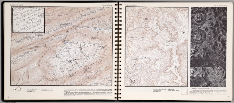
Full Title
Domes & Basin. Centripetal Drainage. Burkes Garden, VA. (on opposite page) Cryptovocanic Domes. Upheaval Dome, Utah. (with inset view) Stereopair of Upheaaval Dome ...
List No
0889.019
Note
Two contour maps on two pages, includes text, and outline location map. Inset: Magnified section of the Centripetal drainage patterns. Relief shown by contours and spot height.
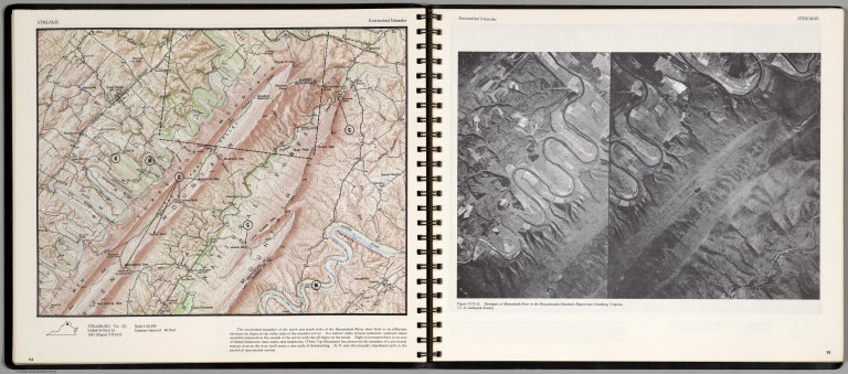
Author
[Scovel, James L., O'Brien, Emmett J]
Full Title
Streams. Entrenched Meander. Strasburg, Va. (S) (on opposite page) Entrenched Meader. Stereopair of Shenandoah River in the Massannutten Mountain Region near Strasburg.
List No
0889.051
Note
Contour map, with text, and location maps. Relief shown by contours and spot heights.
Author
Tanner, Henry S.
Full Title
A New Map of Virginia with the Canals, Roads & Distances from place to place along the Stage & Steam Boat Routes by H.S. Tanner. (inset) Profile of the Chesapeake & Ohio Canal.
List No
0976.019
Author
Tanner, Henry S.
Full Title
A New Map Of Virginia With Its Canals, Roads & Distances from place to place, along the Stage & Steam Boat Routes. by H.S. Tanner. Engraved by W. Brose, Philadelphia. Entered ... 1833 by H.S. Tanner ... Pennsylvania. Published by H.S. Tanner, No. 144 Chesnut St. Philadelphia. (above neat line) Tanner's Universal Atlas.
List No
0977.014
Note
In full color by county with profile of the Chesapeake and Ohio canal. Steamboat routes and distances charted.
Author
Tanner, Henry S.
Full Title
A New Map of Virginia with the Canals, Roads & Distances from place to place along the Stage & Steam Boat Routes by H.S. Tanner. (inset) Profile of the Chesapeake & Ohio Canal.
List No
0980.019
Note
Date estimated. 1836 date scratched off.
Author
Senex, John (c.1678-1740)
Full Title
A New Map of Virginia and the Improved Parts of Pennsylvania & New Jersey.
List No
10014.258
Author
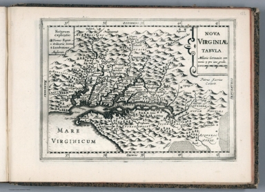
Blaeu, Joan, 1596-1673
Full Title
Nova Virginiae Tabvla
List No
10017.644
Note
12 Milliaria Germanica communia 15 pro Uno gradu = 7.9 cm
Author
[Mercator, Gerhard, 1512-1594, Hondius, Jodocus, 1563-1612, Hondius, Hendrik, 1597-1651]
Full Title
Nova Yirginiae Tabula Amstelodami, ex officina Henrici Hondii.
List No
10621.197
Note
Inset: Status Regis Powhatan quando praefectus Smith Captivus i!Ji daretur (Picture). 10 x 8 cm.
Author
[Mercator, Gerhard, 1512-1594, Hondius, Iodocus, 1563-1612]
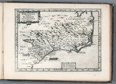
Full Title
Virginia et Florida. (to accompany) Atlas minor Gerardi Mercatoris.
List No
11201.455
Note
Map of Virginia and Florida, eastern coast of North America from the Chesapeake Bay south to St. Augustine. Several named towns are shown along the coast, and the Native American village of Secotan is shown in what is now eastern North Carolina. Shows British and Spanish colonies. Relief shown pictorially.
Author
[Mercator, Gerhard, 1512-1594, Hondius, Jodocus, 1563-1612, Saltonstall, Wye]
Full Title
Virginia. Virginia et Florida. (to accompany) Historia mundi : or Mercator's atlas. London Printed for Michaell Sparke, . and are to be sowld in Greene Arboiure, 1637. Second edytion.
List No
11248.665
Note
Copper-engraving uncolored map of Virginia and Florida, eastern coast of North America. Several named towns are shown along the coast, and the Native American village of Secotan is shown in what is now eastern North Carolina.Relief shown pictorially.
Author
[Janssonius van Waesberge, Johannes, Kaerius, Petrus, Mercator, Gerhard, 1512-1594, Cloppenburg, Johannes, 1592-1652]
Full Title
Nova Virginiae tabula. Petrus Kaerius Caelavit. (to accompany) Atlas sive Cosmographicae Meditationes de Fabrica mundi et fabricati figura. De novo multis in locis emendatus novisque tabulis auctus. Amsterodami, apud Iohannem Ianssonium van Waesberge. Anno, 1673.
List No
11487.176
Note
Copper engraved map of Virginia, showing Chesapeake Bay regionand the surrounding environs. Shows towns, villages, landmarks, mountains, Indian Tribes, and rivers. Relief shown pictorially. Includes explanations.
Author
[Janssonius van Waesberge, Johannes, Mercator, Gerhard, 1512-1594, Cloppenburg, Johannes, 1592-1652]
Full Title
Virginiae item et Floridae Americae Provinciarum, nova descriptio. (to accompany) Atlas sive Cosmographicae Meditationes de Fabrica mundi et fabricati figura. De novo multis in locis emendatus novisque tabulis auctus. Amsterodami, apud Iohannem Ianssonium van Waesberge. Anno, 1673.
List No
11487.177
Note
Copper engraved map of the southeastern part of North America, covers Virginia and Florida. Cover the coast from Chesapeake Bay to St. Augustine. Shows towns, villages, mountains, Indian settlement, and rivers. Relief shown pictorially. Includes notes.
Author
Meyer, Joseph, 1796-1856
Full Title
Die Staaten von New York, Pennsylvania, Maryland, New Jersey, Delaware & Virginia. 1850. Stahlstich (Direction v. Kleinknecht) aus der Schweinfurter Geographischen Graviranstalt des Bibliographischen Instituts zu Hildburghausen, Amsterdam, Paris u. Philadelphia. (in upper margin) Meyer's Zeitung Atlas. No. 70. (to accompany) Neuester Zeitungs-Atlas fur Alte und Neue Erdkunde. Herausgegeben von J. Meyer.
List No
11652.094
Note
Engraved outline hand color map of the Mid-Atlantic States. With 6 insets: New York and vicinity, Philadelphia and vicinity, Niagara Falls and vicinity, Albany and vicinity, Pittsburg and vicinity and Baltimore and Washington DC and vicinity. Shows administrative boundaries, cities and towns. Relief shown by hachures. Prime meridians are Greenwich and Washington.
Author
Speed, John, 1542-1629
Full Title
A Map of Virginia and Maryland.
List No
12058.211
Author
[Jaillot, Alexis Hubert, 1632?-1712, Mortier, Pierre, Sanson, Nicolas, 1600-1667]
Full Title
Carte Particuliere de Virginie, Maryland, Pennsilvanie.
List No
12178.216
Author
[Weiland, Carl Ferdinand, 1782 -1847, Hassel, Georg, 1770-1829]
Full Title
Geographisch-statistische und historische Charte von Virginia.
List No
12293.025
Author
[Chatelain Henri, 1684-1743, Gueudeville, Nicolas]
Full Title
Carte qui contient une description des iles & terres que les Anglois possedent dans l'Amerique Septentrionale : et en particulier de la Jamaique, des iles Barbades ... Tom. VI. No. 26. Pag. 100. (to accompany) Atlas Historique ... Tome VI. A Amsterdam, chez L'Honore & Chatelain Libraires. M DCC XIX (1719).
List No
13272.697
Note
7 engraved maps on 1 sheet, Including: Carte de la Jamaique, with inset: Partie de la Mer de Sud. Ile des Barbades. Nouvelle Angreterre et Nouvel. York. Barmudes. Nouvelle Carte de la Caroline. Nouvelle carte de la Pensylvanie. Maryland, Virginie et Nouvelle Jarsey. Partie de l'Amerique Septentrionale. Includes descriptive text. Relief shown pictorially.
Author
Finley, Anthony
Full Title
Virginia. J.H. Young Sc. Published by A. Finley Philada. (to accompany) A new general atlas, comprising a complete set of maps, representing the grand divisions of the globe ... 1836.
List No
13379.022
Note
Full color map by administrative divisions.
Author
[George F. Cram Company collection 1845-1955, National Highways Association]
Full Title
Virginia. The George F. Cram Company, Chicago. (to accompany) Auto trails and commercial survey of the United States.
List No
13688.095
Note
State of Virginia. Inset: Norfolk, Newport News, and vicinity. Showing Main highways.
Author
[George F. Cram Company collection 1845-1955, National Highways Association]
Full Title
Virginia. The George F. Cram Company, Chicago. (to accompany) Auto trails and commercial survey of the United States.
List No
13688.096
Note
State of Virginia. Inset: Norfolk, Newport News, and vicinity. Showing electric lines and administrative boundaries.
Author
Cassini, Gio. Ma. (Giovanni Maria), 1745-approximately 1824
Full Title
(26) Gli Stati Uniti dell'America delineati sulle ultime osservazioni. Terzo foglio che comprende parte della Virginae della Carolina. Roma, presso la Calcografia Camerale, 1797.
List No
14000.197
Note
Relief shown pictorially. Includes decorative title cartouche and bar scales. In Volume III.
Author
Rand McNalley & Company
Full Title
Rand McNally road map : Delaware -- Maryland -- Virginia -- West Virginia.
List No
14003.017
Note
Road map of Delaware, Maryland, Virginia and West Virginia, showing interstate and state highways, paved and dirt roads, ferries and boatlines, as well as state and national parks. Includes compass rose, time zones, and bar scale with scale statement: One inch equals approximately 19.5 miles. Features legend indicating population. Copyright by Rand McNally & Company, Chicago, Ill. Lithographed in the U.S.A.
Author
[Morden, Robert, approximately 1650-1703, Cockerill, Thomas, active 1674-1702]
Full Title
(Text Page to) Of the North West part of America (4) -- Of Virginia & Maryland (1).
List No
14323.178
Note
On left - descriptive text for map, The North West part of America, on prior page (363). Includes section: Of the English Empire in America. 363 [365]-368 [370]; 370 misprinted as 368. On right - map of Virginia and Maryland. Map includes title cartouche: A new map of Virginia and Maryland, by Robt. Morden. Shows political boundaries, cities, drainage, coastline and islands. Indexed and contains a compass rose, as well as latitudinal and longitudinal lines. Map is 12 x 10 cm, on sheet 15 x 20 cm. Accompanied by descriptive text. Text spans pages 369-372.
Author
[Morden, Robert, approximately 1650-1703, Cockerill, Thomas, active 1674-1702]
Full Title
(Text Page to) Of New England (4) -- A description of Carolina (1).
List No
14323.183
Note
On left - descriptive text for map, New England and New York, on prior page (373). Text spans pages 373-378. Includes section: New York. Text spans pages 369-372. On right - map of the South Atlantic States. Map includes title cartouche: Carolina, Virginia, Maryland & New Jarsey, by Robt. Morden. Shows political boundaries, cities, topography, drainage, coastline and islands. Relief shown pictorially. Contains latitudinal and longitudinal lines. Map is 12 x 11 cm, on sheet 15 x 20 cm. Accompanied by descriptive text. Text spans pages 379-383.
Author
[Weekly Dispatch, Weller, Edward, 1819-1884]
Full Title
Seat of War in Virginia, &c. : Sheet 2 [Sheet 1]./ E. Weller, Lith. Red Lion Sq.
List No
14360.255
Note
Map of the "Seat of War" during the United States Civil War in Virginia, Maryland and Pennsylvania (sheet 2). Shows political boundaries, cities, railways, roads, topography, bodies of water and drainage. Relief shown with hachures. Includes latitudinal and longitudinal lines, as well as bar scales given in statute miles. Hand-colored lithograph. Map is 45 x 61 cm, on two sheets, together 48 x 69 cm. Followed by "Seat of War in Virginia : Sheet 3" on subsequent plate. Sheets presented in sequence. Appears in Vol. II : For
Author
[Weekly Dispatch, Weller, Edward, 1819-1884]
Full Title
Seat of War in Virginia : Sheet 3 / E. Weller, Lith. Red Lion Square.
List No
14360.257
Note
Map of the "Seat of War" during the United States Civil War in Virginia (sheet 3). Shows political boundaries, cities, railways, roads, topography, bodies of water and drainage. Relief shown with hachures. Includes latitudinal and longitudinal lines, as well as a bar scale given in statute miles. Hand-colored lithograph. Map is 30 x 45 cm, on sheet 33 x 48 cm. Plate number handwritten in ink at upper and lower left corners of sheet. Preceded by maps entitled "Seat of War in Virginia, &c. : Sheet 2 -- Seat of War in Virginia and Maryland : [Sheet 1]" on previous plates. Appears in Vol. II : Foreign.
Author
Cram, George Franklin, 1841-1928
Full Title
Western half of Virginia and West Virginia. 1899, by Geo. F. Cram.
List No
14372.052
Note
Map of Virginia and West Virginia (western half). Shows political boundaries, counties, towns, railroads, steamship lines, topography, bodies of water, drainage, coastlines and islands. Relief shown with hachures. Includes key with explanation, latitudinal and longitudinal lines, as well as a bar scale given in miles. With alphanumeric grid corresponding to "Index of Virginia" on pages 85-93 and 96-98, and "Index of West Virginia" on pages 99, 102-105 and 108-110. Colored lithograph. Map is 55 x 43 cm, on double sheet 67 x 45 cm. "Index of maps" and "Index of cities" in margins, providing navigation for atlas as a whole. Eastern half of map follows on pages 100-101.
Author
Cram, George Franklin, 1841-1928
Full Title
Eastern half of Virginia and West Virginia. 1899, by Geo. F. Cram.
List No
14372.055
Note
Map of Virginia and West Virginia (eastern half). Shows political boundaries, counties, towns, railroads, steamship lines, topography, bodies of water, drainage, coastlines and islands. Relief shown with hachures. Includes key with explanation, latitudinal and longitudinal lines, as well as a bar scale given in miles. With alphanumeric grid corresponding to "Index of Virginia" on pages 85-93 and 96-98, and "Index of West Virginia" on pages 99, 102-105 and 108-110. Colored lithograph. Map is 55 x 42 cm, on double sheet 67 x 45 cm. "Index of maps" and "Index of cities" in margins, providing navigation for atlas as a whole. Western half of map precedes on pages 94-95.
Author
Cram, George Franklin, 1841-1928
Full Title
Virginia and West Virginia. 1899, by Geo. F. Cram.
List No
14372.059
Note
Map of Virginia and West Virginia. Shows political boundaries, counties, towns, railroads, steamship lines, topography, bodies of water, drainage, coastlines and islands. Relief shown with hachures. Includes key with explanation, latitudinal and longitudinal lines, as well as a bar scale given in miles. Inset map: South west part of Virginia. With alphanumeric grid corresponding to "Index of Virginia" on pages 85-93 and 96-98, and "Index of West Virginia" on pages 99, 102-105 and 108-110. Colored lithograph. Map is 40 x 55 cm, on double sheet 45 x 67 cm. "Index of maps" and "Index of cities" in margins, providing navigation for atlas as a whole.
Author
Greenleaf, Jeremiah
Full Title
Virginia. (with) The Western Part of Virginia.
List No
15176.046
Note
Full color by county. Engraved. Relief shown by hachures. Meridians Greenwich and Washington.
Author
Colton, G.W.
Full Title
Colton's Delaware, Maryland, Virginia and West Virginia. (insets) District of Columbia; Richmond, Henrico County, Manchester and Spring Hill, Chesterfield County, Norfolk, Portsmouth and Gosport. Published By G. W & C. B. Colton & Co. No. 182 William St. New York.
List No
1550.033
Note
Prime meridian is Greenwich.
Author
[Black, Adam, Black, Charles]
Full Title
Virginia, Maryland & Delaware.
List No
1585.065
Author
[Colton, G.W., Fisher, Richard Swainson]
Full Title
Maryland, Virginia, North Carolina, and South Carolina. (inset) The District of Columbia. (inset) Vicinity of Charleston. (inset) Vicinity of Baltimore, Md.
List No
1690.074
Note
Relief shown by hachures.
Author
[Cram, George, Wood Brothers]
Full Title
Virginia, West Virginia, Maryland & Delaware. (to accompany) The Columbian World's Fair atlas ... Published for: Wood Brothers Cash Store ... Unadilla, New York.
List No
1773.056
Note
Outline hand color map. Covers Virginia, West Virginia and part of Maryland and Delaware. Shows state and county boundaries, cities and towns. Depth shown by isolines. Prime meridians are Greenwich and Washington.
Author
[Atkinson, W. G., United States. War Department, Whipple, Amiel W.]
Full Title
Plan of the battle-field at Bull Run, July 21st, 1861, to accompany the Report of Brig. Genl. Irvin McDowell, commanding, prepared by Capt. A.W. Whipple, Topl. Engrs, 1st Lieut. H.L. Abbot ... (and) 1st Lieut. H.S. Putnam ..., drawn by J.J. Young, civil engineer. Map of the battle-fields of Manassas and the surrounding region, showing the various actions of the 21st July, 1861, between the armies of the Confederate States and the United States, surveyed and drawn by W.G. Atkinson, acting 1st Lieut., Engineers. Julius Bien & Co., Lith., N.Y. (1891-1895)
List No
1780.003
Note
Two col. maps on 1 sheet. Relief shown by hachures. "Series I., vol. 2." With facsimile signature "Presented to the city of New Orleans by General G.T. Beauregard, Gen., comdg."
Author
[Michler, Nathaniel, United States. War Department]
Full Title
Battle-field of Youngs Branch or Manassas Plains, battle fought July 21st, 1861. Tracing forwarded to the Chief of Engineers U.S.A. by Maj. N. Michler ... Map of the rebel fortifications at Columbus, Ky., surveyed under the direction of Brig. Genl. Geo. W. Cullum, Chief of Staff and engineers, Dept. of the Mississippi, 1862. (with) Map showing the position of the batteries used by the U.S. forces in the reduction of Fort Pulaski, April 10th & 11th, 1862. Accompanying Report of Brig. Gen. Quincy A. Gillmore, U.S. Vols. (with) Siege of Fort Pulaski, map of the mouth of Savannah River and adjacent islands ... (with) Action at Front Royal, Va., May 23d. 1862. Accompanying Report of Lieut. Col. Charles Parham, Twenty-ninth Pennsylvania Infantry. (with) Sketch of Fort Pickens, Florida, by Lt. Langdon ... 1861. (with) Reconnaissance of the battle-field at Bull Run, Va., fought July 21, 1861. Made on March 14, 1862 by Henry L. Abbot ... (with) Skirmishes near Bailey's Cross-roads, Va., August 28-30, 1861. Accompanying Report of Major S.G. Champlin ... (with) Accompanying Report of Brig. Gen. Louis Blenker, U.S. Vols., of information obtained from scouting parties, dated Hunter's Chapel, Va., Nov. 5, 1861. Julius Bien & Co., Lith., N.Y. (1891-1895)
List No
1780.005
Note
Two col. maps with 8 ancillary maps. Relief shown by contours, hachures and spot heights. Scales of main maps ca. 1:26,400 and 1:14,400.
Author
[Dorr, F. W., Rockwell, Cleveland, United States. War Department, Whiting, H. L.]
Full Title
Defenses of Washington. Map of the ground of occupation and defense of the Division of the U.S. Army in Virginia in command of Brig. Gen. Irvin McDowell. U.S. Coast Survey, A.D. Bache, Supdt. Topographical survey by the party in charge of H.L. Whiting, Asst., U.S.C.S. Field work executed during parts of June and July 1861, by F.W. Dorr and C. Rockwell U.S.C.S. (with) Sketch of Paducah, Ky. and vicinity by Captain John Rziha, 19th U.S. Infantry. (with) Sketch of the battle-field of Logan's Cross-roads, Ky. U.S. forces under the command of Brig. Gen. George H. Thomas. Forces of the enemy commanded by General G.B. Crittenden, Jan. 19, 1862. Drawn under the direction of Capt. Michler ... copied by A. Kilp. Sketch of the enemy's fortified position at and opposite Mill Springs, Ky., to which he retreated after his defeat at Logan's Cross-roads by the U.S. forces under Brig. Gen. George H. Thomas, Jan. 19, 1862 ... compiled ... by Edward Ruger ... drawn by A. Kilp ... Julius Bien & Co., Lith., N.Y. (1891-1895)
List No
1780.006
Note
Col. map with 2 ancillary maps. Relief shown by contours. Insets show relief by hachures.
Author
[Hesselbach, W., U.S. War Department, Topographical Engineers, United States. War Department, Young, J. J.]
Full Title
Surveys for military defenses. Map of northeastern Virginia and vicinity of Washington. Sheet 1. Compiled in Topographical Engineers Office at division headquarters of General Irvin McDowell, Arlington, January 1, 1862. Corrected from recent surveys and reconnaissances under direction of the Bureau of Topographical Engineers, August 1, 1862. Drawn by J.J. Young and W. Hesselbach. Julius Bien & Co., Lith., N.Y. (1891-1895)
List No
1780.007
Note
Col. map. Relief shown by hachures; depths by soundings. Includes "Geological profile of Loudoun County." "Accompanying the report of Maj. Gen. George B. McClellan, U.S. Army ... and Record of the McDowell Court of Inquiry ..."
Author
[Hesselbach, W., U.S. War Department, Topographical Engineers, United States. War Department, Young, J. J.]
Full Title
Surveys for military defenses. Map of northeastern Virginia and vicinity of Washington. Sheet 2. Compiled in Topographical Engineers Office at division headquarters of General Irvin McDowell, Arlington, January 1, 1862. Corrected from recent surveys and reconnaissances under direction of the Bureau of Topographical Engineers, August 1, 1862. Drawn by J.J. Young and W. Hesselbach. Julius Bien & Co., Lith., N.Y. (1891-1895)
List No
1780.008
Note
Col. map. Relief shown by hachures; depths by soundings. "Accompanying the report of Maj. Gen. George B. McClellan, U.S. Army ... and Record of the McDowell Court of Inquiry ..."
Author
United States. War Department
Full Title
Map showing the system of rebel fortifications on the Mississippi River at Island No. 10 and New Madrid, also the operations of the U.S. forces under General John Pope against these positions. (with) Route from Keetsville to Fayetteville, Ark. (with) Plan of the battle-field of Pea Ridge, Ark. Surveyed by H.A. Ulffers ... and A. Hoeppner ... (with) Route followed by the command of Maj. Joseph Conrad ... from near Bentonville, Ark. to Cassville, Mo., March 4-7, 1862. (with) Sketch A. Battle-field of Pea Ridge, Ark, March 7th, 1862 accompanying Report of Capt. Louis Hoffmann ... (with) Sketch B. Battle-field of Pea Ridge, Ark, March 8th, 1862 ... (with) Rebel position at Centreville, reconnaissance of March 14th, 1862 by M.D. McAlester ... (with) Battle at Leetown, March 7th, 1862. (with) Manassas Junction and vicinity surveyed by party of U.S. Coast Survey ... to act under orders of Lt. Col. J.N. Macomb ... Field work under direction of H.L. Whiting ... April 1862. (with) Sketch of battle-field at Shiloh near Pittsburg Landing, Tenn., April 6 and 7, 1862. Julius Bien & Co., Lith., N.Y. (1891-1895)
List No
1780.010
Note
Col. map with 9 ancillary maps. Relief in some ancillary maps shown by contours or hachures.
Author
[Matz, Otto H., United States. War Department]
Full Title
Map of the country between Monterey, Tenn. and Corinth, Miss. showing the lines of intrenchments made and the routes followed by the U.S. forces under the command of Maj. Genl. Halleck, U.S. Army, in advance upon Corinth in May 1862. Surveyed under the direction of Col. Geo. Thom ... by lieuts. Fred Schraag and C.L. Spangenberg ... and drawn by Lieut. Otto H. Matz ... (with)Sketch of the battle field of Shiloh showing the dispositions of the troops under the command of Major General D.C. Buell on the 6th and 7th of April, 1862. Surveyed ... by Capt. N. Michler ... Assisted by John E. Weiss. (with) Advance upon Corinth, Miss., May 1862. Map accompanying report of Maj. Gen. W.T. Sherman, Wm. Kossak ... (with) Sketch of the position of the Army of the Potomac at Harrison's Landing, Va., 1862. Report of Maj. Gen. Geo. B. McClellan ... (with) Sketch of the positions of signal stations at Harrison's Landing, Va., 1862. Report of Maj. A.J. Myer ... (with) Sketch of the affair at Dranesville, Va., Dec. 20, 1861 between the government troops and the rebels. Accompanying report of Brig. Genl. E.O.C. Ord ... Julius Bien & Co., Lith., N.Y. (1891-1895)
List No
1780.013
Note
Col. map with 5 ancillary maps. Relief shown by hachures.
Author
[Abbot, Henry L., Comstock, Cyrus B., United States. War Department, Wagner, Orlando G.]
Full Title
Reconnaissance of secession works and plan of Siege of Yorktown. Made under orders of Gen'l. Barnard and Maj. Humphreys by Lieut. Abbot, Top. Engrs., Lieut. Comstock, Engrs., Lieut. Wagner, Top. Engrs. April and May 1862. Map no. 1. siege plan ... (with) Map of the battle-field of Shiloh, April 6th and 7th 1862. Accompanying report of Gen. G.T. Beauregard ... Topographical sketch of the line of operations of the Army of the Ohio, under the command of Major General D.C. Buell. Evacuation of Corinth by the enemy, May 30th, 1862 ... surveyed ... 1862 by N. Michler ... assisted by John E. Weiss (i.e. Weyss) ... Julius Bien & Co., Lith., N.Y. (1891-1895)
List No
1780.014
Note
Col. map with 2 ancillary maps. Relief shown by hachures.
Author
[Abbot, Henry L., Comstock, Cyrus B., United States. War Department]
Full Title
Reconnaissance of the secession works at Yorktown, Va. made by Lieut Abbot, Topl. Eng'rs. and at Gloucester, Va. made by Lieut. Comstock, Eng'rs., May 4, 1862. For Gen. J.G. Barnard ... (with) Sketch exhibiting the position of Yorktown with the approaches from reconnaissance and survey between the 5th and 10th of April 1862. By command of Maj. Gen. Geo. B. McClellan ... A.A. Humphreys ... Reconnaissance of Red Redoubt Group to right of Yorktown made by Lieut. N.G. Hall ... (with) The position of Yorktown with the approaches from reconnaissances and surveys made by command of Maj. Gen. Geo. B. McClellan ..., prepared under the direction of Maj. A.A. Humphreys ... April 21st 1862. Julius Bien & Co., Lith., N.Y. (1891-1895)
List No
1780.015
Note
Col. map with 3 ancillary maps. Relief shown by hachures.
Author
U.S. War Department, Topographical Engineers
Full Title
Part of the map of the Military Department of Southeastern Virginia and Fort Monroe. Compiled in the Bureau of Topographical Engineers of the War Department, August 1861. Julius Bien & Co., Lith., N.Y. (1891-1895)
List No
1780.016
Note
Col. map. Relief shown by hachures. Shows settlements, roads, railroads, intrenchments, etc.
Author
U.S. War Department, Topographical Engineers
Full Title
Part of the map of the Military Department of Southeastern Virginia and Fort Monroe showing the approaches to Richmond and Petersburg. Compiled in the Bureau of Topographical Engineers of the War Department. 1861. (with) Picket line of First Brigade and reconnaissance toward Lee's Mill, Va., April 28, 1862. (with) Reconnaissance toward Lee's Mill, Va., April 28, 1862. Julius Bien & Co., Lith., N.Y. (1891-1895)
List No
1780.017
Note
Col. map. Relief shown by hachures. Shows settlements, roads, railroads, entrenchments, etc.
|


![Seat of War in Virginia, &c. : Sheet 2. [Sheet 1].](https://www.davidrumsey.com/rumsey/Size2/RUMSEY~8~1/199/14360255.jpg)