|
Author
[Hughes, William, 1818-1876, Bartholomew, John, 1831-1893]
Full Title
The United States of North America. (North Eastern Division.) By J. Bartholomew, F.R.G.S. George Philip & Son, London & Liverpool.
List No
14487.034
Note
Map representing the Northeast part of the United States of America. Maps show political boundaries, cities, topography, railways, bodies of water, drainage, and coastlines. Relief shown with hachures. Maps include latitudinal and longitudinal lines, as well as bar scales given in English miles, geographical miles, and kilometers. With one inset map: Sketch showing the whole area of the United States. Colored lithograph. Together, maps are 51 x 65 cm, on double sheet 56 x 70 cm.
Author
[Hughes, William, 1818-1876, Bartholomew, John, 1831-1893]
Full Title
The Pacific states, the territories and a portion of the north-western states. (United States, No.II (Western Division.). By J. Bartholomew, F.R.G.S. George Philip & Son, London & Liverpool.
List No
14487.035
Note
Map representing the Western part of the United States of America. Shows political boundaries, cities, indigenous territory, topography, railways, bodies of water, drainage, and coastlines. Relief shown with hachures. Includes latitudinal and longitudinal lines, as well as bar scales given in English miles, geographical miles, and kilometers. Colored lithograph. Map is 52 x 62 cm, on double sheet 56 x 70 cm.
Author
[Hughes, William, 1818-1876, Bartholomew, John, 1831-1893]
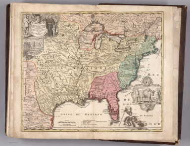
Full Title
United States of North America : (South Eastern Division.) The Confederate states, with the border states & the adjoining portion of the federal states. By J. Bartholomew, F.R.G.S. George Philip & Son, London & Liverpool.
List No
14487.036
Note
Map representing the Southeast part of the United States of America. Shows political boundaries, cities, indigenous territory, topography, railways, bodies of water, drainage, and coastlines. Relief shown with hachures. Includes latitudinal and longitudinal lines, as well as bar scales given in English miles, geographical miles, and kilometers. Colored lithograph. Map is 52 x 61 cm, on double sheet 56 x 70 cm.
Author
[Ford Motor Company, United States. Department of Commerce. Aeronautics Branch]
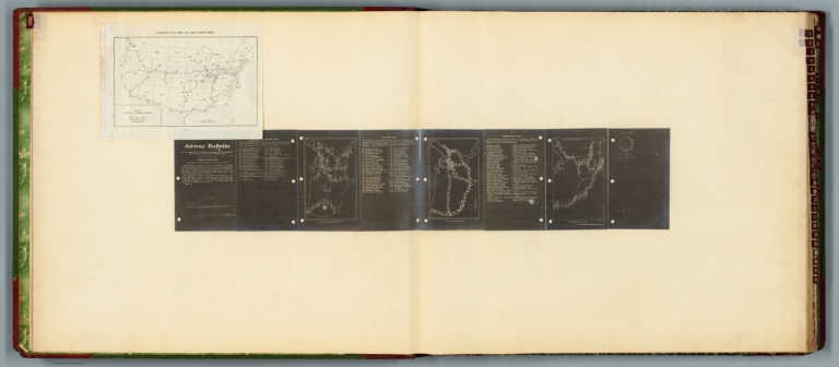
Full Title
Commerce and Army Air Corps airway maps : Department of Commerce maps -- Air Corps maps -- Hydrographic Office. Airway bulletin. No. 11a, August 26, 1927. Published in Information Division, Aeronautics Branch, Department of Commerce, Washington, D.C. U.S. Government Printing Office : 1927.
List No
14501.002
Note
Four aeronautical charts of the United States. Charts feature airway strips. Charts also show political boundaries, cities with airports, bodies of water and coastlines. The first chart (printed on a white plate) is an index to the following three charts (printed in white on a black plate). The index chart includes a legend and bar scale given in miles. The following three charts each pertain to different departments - the Department of Commerce, Air Corps and Hydrographic Office - and each chart has a list of available maps, which are identifiable through the index map. Both plates are pasted to a double sheet. Together, maps are 37 x 99 cm, on double sheet, 60 x 136 cm.
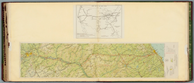
Author
[Ford Motor Company, U.S. Coast and Geodetic Survey, United States. Department of Commerce. Aeronautics Branch. Air Information Division]
Full Title
Airway map no. 112 : Milwaukee to St. Paul - Minneapolis. Compiled and printed for the Aeronautics Branch of the Department of Commerce by the Coast and Geodetic Survey, Washington, D.C. Jan. 1930. -- Airway map of the United States : Information bulletin no. 8. Department of Commerce, Aeronautics Branch, Information Division, Washington, D.C. March 15, 1928.
List No
14501.035
Note
Two aeronautical charts representing the areas from Milwaukee, Wisconsin, to Saint Paul - Minneapolis, Minnesota, and a map of airway routes for the United States and Cuba. Airway map no. 112 features military, municipal, and commercial landing fields, as well as beacons. Also shows political boundaries, roads, railways, cities, towns, topography, bodies of water, drainage, and shorelines. Relief shown with contour lines and color coding. Includes a legend, scale statement, and bar scales given in miles, as well as compass rose oriented toward top of sheet. With the seal of the Department of Commerce, United States of America. The Airway map of the United States shows airway routes under contract or proposed for mail and passengers. Color lithographs and black and white lithograph, respectively. Together, maps are 56 x 118 cm, on double sheet, 60 x 136 cm.
Author
Gulf Refining Company
Full Title
Rand McNally Airway map : United States. Copyright, 1935 by Rand McNally & Company, Chicago. 11-35. (at upper margin) United States air transport routes. (to accompany) 1935-1936, Aviation Atlas. Fourth Edition.
List No
13357.004
Note
Color map of the United States. Shows air transport routes. Includes inset and schedule of airlines. Relief shown by shadings.
Author
Gulf Refining Company
Full Title
The United States grows smaller by air hours. (to accompany) 1935-1936, Aviation Atlas. Fourth Edition.
List No
13357.015
Note
Map and table. Map shows "Comparison pf distances based on Air Mail and regular mail time." Table shows: Air mail and railroad mail time between principal cities.
Author
Cram, George Franklin, 1841-1928
Full Title
Map of the United States of America.
List No
14372.291
Note
Map of the United States. Shows political boundaries, cities, railroads, topography, bodies of water, drainage, shorelines and islands. Relief shown with hachures. Includes latitudinal and longitudinal lines. Inset map: Alaska. Colored lithograph. Map is 32 x 49 cm, on double sheet 45 x 67 cm.
Author
Andriveau-Goujon, E. (Eugène), 1832-1897
Full Title
(24) Carte générale des États-Unis et du Mexique comprenant l'Amérique centrale et les Antilles. E. Andriveau-Goujon, éditeur. Paris, Rue du Bac, 4. Nouvelle édition, 1876.
List No
14008.028
Note
Hand-colored, engraved map of the United States, Mexico, Central America and the Antilles, showing railroads and water routes (on double plate with decorative border). Includes legend indicating European colonies (French, English, Dutch, Danish, Spain and Swedish), as well as 4 bar scales. "No. 24" in upper right. With 4 insets: États de l'Amérique Centrale -- Entré de New-York -- Carte des rapports entre l'Europe & l'Amérique -- Petites Antilles et Nord de l'Amérique du Sud.
Author
W. & A.K. Johnston Limited
Full Title
United States. Edinburgh; W. & A.K. Johnston ; Glasgow; Robert Weir ; Lumsden & Son.
List No
14296.050
Note
Map of the eastern United States and vicinity, including the West Indies. Shows political boundaries, cities, routes, topography, prairies, drainage, coastlines and islands. Relief shown pictorially. Includes latitudinal and longitudinal lines, as well as a bar scale. "Longitude West from Greenwich." With a statistical table featuring surface area, population, capital city, revenue, debt, military resources and religion. Map is 22 x 29 cm, on sheet 27 x 35 cm. Hand-colored engraving. In second section of atlas, Modern maps.
Author
Philip, George, 1870-1937.
Full Title
The Pacific States and a Portion of the North-Western States (United States II Western Division)
List No
15487.130
Author
[George F. Cram Company collection 1845-1955, National Highways Association]
Full Title
National Parks : Showing Highway Connections. (to accompany) Auto trails and commercial survey of the United States.
List No
13688.005
Note
Map 22x26 on sheet 38x28. Showing National parks and monuments. Highways and roads in red lines, National monuments are marks. With inset maps of National Parks in Alaska; Main; Hawaiian Island. Beneath the map is List of the United States National Parks "The National Parks at a glance. Administered by the National Park Service Department of the Interior" Includes Reference.
Author
[George F. Cram Company collection 1845-1955, National Highways Association]
Full Title
United States. The George F. Cram Company, Chicago. Transcontinental highways of the United States. (to accompany) Auto trails and commercial survey of the United States.
List No
13688.007
Note
Map of the United states on 2 sheets. Transcontinental routes shown in red lines and numbers. Includes list of transcontinental routes of the United States.
Author
[George F. Cram Company collection 1845-1955, National Highways Association]
Full Title
Highway pole markers. (to accompany) Auto trails and commercial survey of the United States.
List No
13688.009
Note
Pole markers shown in the original colors.
Author
[George F. Cram Company collection 1845-1955, National Highways Association]
Full Title
Map of the United states and possessions. The George F. Cram Company, Chicago. Federal Reserve Banking Districts. (to accompany) Auto trails and commercial survey of the United States.
List No
13688.010
Note
Map of the United States Banking districts. With insets: Canal Zone (Panama); Porto Rico (Puerto rico); Hawaii; Wake I.; Samoa; Guam; Alaska; Philippine Islands.
Author
Conference of Local Airlines
Full Title
(Text Page to) Fly all the way to 500 cities and towns served by local airlines. Conference of Local Airlines. 800 World Center Building, Washington 6, D.C.
List No
14446.003
Note
Verso to Fly all the way to 500 cities and towns served by local airlines, unfolded. Features an illustration of the United States, including topography. Relief shown with shading. With descriptive text. Printed in red and black.
Author
[United States. Office of War Information, United States. Army. Western Defense Command, United States. Wartime Civil Control Administration]
Full Title
Geographical distribution : Japanese population, United States : 1940. Western Defense Command and Fourth Army, Wartime Civil Control Administration.
List No
14375.026
Note
Map of the United States, featuring the geographical distribution of the Japanese American population in the United States in 1940. Shows political boundaries and the number of Japanese Americans in each state, utilizing data visualization to illustrate population density. Includes explanatory note. In color. Map is 15 x 23 cm. Figure 5-b. Appears in Part IV : Evacuation - its operational technique, Chapter VIII : Development and execution of the evacuation plan. (Page number inferred.)
Author
[United States. Office of War Information, United States. Army. Western Defense Command, United States. Wartime Civil Control Administration]
Full Title
Net voluntary movement of Japanese : Western Defense Command Area, March 12th to June 5th, 1942. Western Defense Command and Fourth Army, Wartime Civil Control Administration.
List No
14375.033
Note
Map of the United States, featuring the allegedly voluntary migration of Japanese Americans in the Western Defense Command Area, from March 12th to June 5th, 1942. Shows political boundaries and utilizes data visualization to illustrate population density within the migration to different places. Includes a legend and explanatory note. Black and white. Map is 11 x 16 cm, on sheet 15 x 23 cm. Figure 11. Appears in Part IV : Evacuation - its operational technique, Chapter IX : Voluntary migration.
Author
United States. Office of War Information
Full Title
War relocation project sites.
List No
14375.076
Note
Map of the United States featuring the war relocation project sites. Shows political boundaries, cities and roads. Includes a legend. In color. Map is 14 x 18 cm, on sheet 15 x 23 cm. Figure 21. With descriptive text on facing page. Appears in Part VI : Relocation of evacuees, Chapter XXI : The construction and equipment of relocation centers.
Author
[Pershing, John J. (John Joseph), 1860-1948, Geological Survey (U.S.)]
Full Title
Map of France superimposed on that of the United States : Showing relative distances and the extent of railroad systems used by the American Expeditionary Forces. House Doc. No. 626; 66th Cong., 2d Sess. Engraved and printed by the U. S. Geological Survey.
List No
14379.023
Note
Military map of France, overlaid upon the United States in order to show the relative distances between different cities. Features the railroad systems used by the American Expeditionary Forces during World War I. Shows political boundaries, cities, drainage, coastlines and islands. Includes a legend, explanatory notes and two bar scales given in kilometers and miles, as well as a compass rose with north oriented toward top of sheet (for the United States). Colored engraving. Map is 20 x 24 cm, on fold-out sheet 23 x 27 cm.
Author
[3, Soviet Union. Glavnoe upravlenie geodezii i kartografii]
Full Title
Соединенные Штаты Америки = Soyedinennye Shtaty Ameriki. 227-228. Atlas Mira : 1954.
List No
13682.241
Note
Physical map of the United States. Relief shown by shadings and spot heights. Depths shown by gradient tints, isolines and soundings.
Author
[3, Soviet Union. Glavnoe upravlenie geodezii i kartografii]
Full Title
Запад США = Zapad SShA. 242-243. Atlas Mira : 1954.
List No
13682.256
Note
Physical map of the West of the United States. Showing state boundaries. Relief shown by shadings, contours and spot heights. Depths shown by gradient tints, isolines and soundings.
Author
Faden, William, 1749-1836
Full Title
The United States of North America, with the British Territories, and those of Spain, according to the Treaty, of 1784. Engrav'd by Wm. Faden. 1793. Published as the Act directs, Feby. 11, 1793, by Willm. Faden, Geographer to the King, Charing Cross.
List No
14383.057
Note
Map of the United States, as of 1793. Shows political boundaries (including colonial possessions), cities, topography, bodies of water, drainage, coastlines, islands and sand banks. Marks territories inhabited by indigenous peoples, such as the "Western Sioux". Relief shown pictorially. Includes latitudinal and longitudinal lines, as well as a legend and two bar scales. Descriptive text throughout, including notes on exploration. Decorative cartouche. Hand-colored engraving. Map is 53 x 61 cm, on double sheet 55 x 75 cm. With stamp: Liverpool Library.
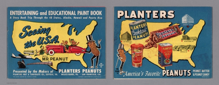
Author
[Fisher, Joseph R., Planters Peanuts (Firm)]
Full Title
(Covers to) Seeing the U.S.A. with Mr. Peanut : A story book trip through the 48 states, Alaska, Hawaii and Puerto Rico / presented by the makers of Planters Peanuts, Planters Nuts & Chocolate Co., Suffolk, Va. Wilkes-Barre, Pa. San Francisco, Cal. This book created by Joseph R. Fisher. Printed in U.S.A.
List No
14374.001
Note
Covers to Seeing the U.S.A. with Mr. Peanut. Bound in paper with a pictorial map of the United States on both the front and back covers, printed in color. Places of publication - Suffolk, Va., Wilkes-Barre, Pa. and San Francisco, Ca. highlighted on map. With illustrations of the character Mr. Peanut, as well as modes of transportation: car, bus, train, plane and ship. "Entertaining and educational paint book". Each cover is 20 x 27 cm, unfolded to 20 x 54 cm.
Author
[Fisher, Joseph R., Planters Peanuts (Firm)]
Full Title
(Text Page to) Mr. Peanut presents this paint book for your pleasure. Planters Nuts & Chocolate Co., Wilkes-Barre, Pa. Suffolk, Va. San Francisco, Calif. Toronto, Canada.
List No
14374.002
Note
Introductory text to Seeing the U.S.A. with Mr. Peanut, on verso of front cover. Text begins: Mr. Peanut is proud to bring you the story of the U.S.A. Rich farms, busy factories, abundant minerals... all have helped to make and keep America great. In this his latest paint book, Mr. Peanut takes you on a make-believe trip through the United States. With a map of the United States. Includes a table providing "Coloring hints".
Author
Weiland, C. F. (Carl Ferdinand), 1782-1847
Full Title
Die Vereinigten Staaten von Nord America entworfen von C. F. Weiland. Weimar, im Verlag des Geograph. Instituts, 1828.
List No
14365.059
Note
Map of the United States, as of 1828. Shows political boundaries, cities, population, topography, bodies of water, drainage, coastlines, islands and territories of indigenous peoples. Relief shown with hachures. Includes latitudinal and longitudinal lines, as well as a legend and two bar scales. With hand-drawn annotation in blue colored pencil. Hand-colored engraving. Map is 30 x 43 cm, on sheet 45 x 57 cm. (Plate number taken from table of contents.)
Author
Desilver, Roberto
Full Title
Mapa de los Estados Unidos de America. Gridley, sc.
List No
14368.004
Note
Map of the United States. Shows political boundaries, cities, railways, canals, topography, bodies of water, drainage, coastlines and islands. Relief shown with hachures. Includes latitudinal and longitudinal lines, as well as a legend and bar scale. With title cartouche. Hand-colored engraving. Map is 33 x 42 cm, on double sheet 45 x 55 cm.
Author
[Raif Efendi, Mahmud, Faden, William (1749-1836)]
Full Title
(United States)
List No
15054.066
Note
For the source map by Faden see https://www.davidrumsey.com/luna/servlet/s/7c59vw
Author
Geological Survey (U.S.)
Full Title
The fifty states.
List No
14359.009
Note
World map highlighting the United States, as of 1970. Shows political boundaries, including those representing Alaska and Hawaii. With distances marked between Washington D. C. and San Francisco, Honolulu and Fairbanks. Colored lithograph. Map is 42 x 32 cm, on sheet 49 x 35 cm. Appears in General reference maps section.
Author
Geological Survey (U.S.)
Full Title
United States general reference. Compiled by U. S. Geological Survey.
List No
14359.010
Note
Map representing the United States, as of 1970. Shows political boundaries, cities, railways, roads, ferry lines, topography, deserts, swamps, bodies of water, drainage, coastlines and islands. Relief shown with shading and peak heights. Features population density for each city. Includes latitudinal and longitudinal lines, a legend, bar scale and scale statement. Presented with Albers Equal Area Projection. With two inset maps: Principal islands of Hawaii -- Alaska. Colored lithograph. Map is 43 x 66 cm, on double sheet 49 x 71 cm. Appears in General reference maps section.
Author
[Geological Survey (U.S.), Harrison, Richard Edes]
Full Title
Perspective views : Outlying areas : Pacific Area / Richard Edes Harrison -- Caribbean Area / Richard Edes Harrison.
List No
14359.011
Note
Two maps representing the Pacific and Caribbean areas, in relation to the United States, as of 1970. Maps show topography, bodies of water, drainage, coastlines and islands. Relief shown pictorially and with color coding. Maps include latitudinal and longitudinal lines. Colored lithograph. Maps are each 20 x 31 cm, on sheet 49 x 35 cm. Maps appear in General reference maps section.
Author
[Geological Survey (U.S.), Harrison, Richard Edes]
Full Title
Shaded relief / Richard Edes Harrison, 1969.
List No
14359.041
Note
Physical map representing the United States, featuring relief, as of 1969. Shows topography, bodies of water, drainage, coastlines and islands. Relief shown with color coding. Includes a legend, latitudinal and longitudinal lines, as well as a bar scale and scale statement. With two inset maps: Principal islands of Hawaii -- Alaska. Presented with Albers Equal Area Projection. Colored lithograph. Map is 43 x 66 cm, on double sheet 49 x 71 cm. Accompanying descriptive text on page 55. Appears in Special subject maps section, subsection Physical : Landforms.
Author
[Geological Survey (U.S.), Hammond, Edwin H.]
Full Title
Classes of land-surface form / adapted from Edwin H. Hammond, "Classes of land surface form in the forty-eight states, U. S.A.," Annals of the Assoc. of Am. Geographers, V. 54, no. 1, 1964, map supp. no. 4, 1:5,000,000.
List No
14359.045
Note
Physical map representing the United States, featuring different land surfaces, such as plains and mountains, as of 1964. Shows political boundaries, topography, bodies of water, drainage, coastlines and islands. Relief shown with color coding. Includes a legend, latitudinal and longitudinal lines, as well as a bar scale and scale statement. With two inset maps: Principal islands of Hawaii -- Alaska. Presented with Albers Equal Area Projection. Colored lithograph. Map is 43 x 66 cm, on double sheet 49 x 71 cm. Accompanying descriptive text on page 55. Appears in Special subject maps section, subsection Physical : Landforms.
Author
[Geological Survey (U.S.), U.S. Coast and Geodetic Survey, United States. Environmental Science Services Administration]
Full Title
Major recorded earthquakes / compiled by U. S. Geological Survey from 1965 data provided by U. S. Coast and Geodetic Survey, Environmental Science Services Administration.
List No
14359.048
Note
Physical map representing the United States, featuring major earthquakes according to intensity, as of 1965. Shows political boundaries, topography, bodies of water, drainage, coastlines and islands. Relief shown with shading. Includes a legend, latitudinal and longitudinal lines, as well as a bar scale and scale statement. With five inset maps: Inset 1 -- Inset 2 -- Inset 3 -- Principal islands of Hawaii -- Alaska. Presented with Albers Equal Area Projection. Colored lithograph. Map is 43 x 66 cm, on double sheet 49 x 71 cm. Accompanying descriptive text on page 55. Appears in Special subject maps section, subsection Physical : Geophysical forces.
Author
[Geological Survey (U.S.), Dolan, Robert, Bosserman, Kenton, Felder, Wilson]
Full Title
Coastal landforms / compiled by Robert Dolan, University of Virginia, assisted by Kenton Bosserman and Wilson Felder, 1967.
List No
14359.057
Note
Physical map representing the United States, featuring coastal landforms, as of 1967. Shows coastline configuration and composition, shoreline characteristics, political boundaries, topography, bodies of water, drainage, coastlines, islands and bathymetry. Relief shown with shading. Includes a legend, latitudinal and longitudinal lines, as well as a bar scale and scale statement. With six inset maps: 1. Sandy Hook to Cape Ann -- 2. Chesapeake Bay and vicinity -- 3. San Francisco Bay Area -- 4. Puget Sound and vicinity -- Principal islands of Hawaii -- Alaska. Presented with Albers Equal Area Projection. Colored lithograph. Map is 43 x 66 cm, on double sheet 49 x 71 cm. Appears in Special subject maps section, subsection Physical : Marine features.
Author
[Geological Survey (U.S.), United States. Naval Oceanographic Office]
Full Title
Sea temperature and salinity / compiled from information provided by U. S. Naval Oceanographic Office, 1968.
List No
14359.060
Note
Sixteen physical maps representing the United States, featuring ocean temperature and salinity, as of 1968. Maps show maximum, minimum and mean temperature in all four seasons, sea surface salinity, political boundaries, bodies of water, coastlines and islands. Maps include legends, as well as bar scales and scale statements. With two inset maps within each map: Principal islands of Hawaii -- Alaska. Colored lithograph. Maps are each 10 x 16 cm, on double sheet 49 x 71 cm. Accompanying descriptive text on page 80. Maps appear in Special subject maps section, subsection Physical : Marine features.
Author
[Geological Survey (U.S.), Küchler, A. W. (August William), 1907-1999]
Full Title
Potential natural vegetation / A. W. Küchler, University of Kansas, 1966.
List No
14359.066
Note
Physical map representing the United States, featuring vegetation, as of 1966. Shows soil vegetation (such as forests and grasslands), political boundaries, bodies of water, drainage, coastlines and islands. Includes legends, latitudinal and longitudinal lines, as well as a bar scale and scale statement. Presented with Albers Equal Area Projection. Colored lithograph. Map is 43 x 66 cm, on double sheet 49 x 71 cm. Accompanying descriptive text on page 89. Appears in Special subject maps section, subsection Physical : Soils.
Author
[Geological Survey (U.S.), United States. Environmental Data Service, United States. Environmental Science Services Administration]
Full Title
Mean monthly sunshine / prepared by U. S. Geological Survey in 1965 from Environmental Data Service, Environmental Science Services Administration records for the period 1931-1960 -- January -- February -- March -- April -- May -- June -- July -- August -- September -- October -- November -- December -- January / adapted from 1:30,000,000-scale maps by Environmental Data Service, Environmental Science Services Administration for the period 1931-1960.
List No
14359.069
Note
Thirteen physical maps representing the United States, featuring the monthly mean for sunshine, as well as monthly sunshine for each month of the year, based upon the period from 1931 to 1960. Maps also show political boundaries, bodies of water, drainage, coastlines and islands. Maps include a legend, as well as a bar scale and scale statements (scales differ). Presented with Albers Equal Area Projection. With two inset maps within each map: Principal islands of Hawaii -- Alaska. Colored lithograph. Together, maps are 42 x 65 cm, on double sheet 49 x 71 cm. Maps appear in Special subject maps section, subsection Physical : Climate.
Author
[Geological Survey (U.S.), United States. Environmental Data Service, United States. Environmental Science Services Administration]
Full Title
Monthly precipitation means and extremes / prepared by U. S. Geological Survey in 1965 from Environmental Data Service, Environmental Science Services Administration records for the period 1931-1960 -- January -- February -- March -- April -- May -- June -- July -- August -- September -- October -- November -- December -- January / adapted from 1:5,000,000-scale maps by Environmental Data Service, Environmental Science Services Administration for the period 1931-1960.
List No
14359.072
Note
Thirteen physical maps representing the United States, featuring the monthly mean for precipitation, as well as monthly precipitation for each month of the year, based upon the period from 1931 to 1960. Maps also show political boundaries, bodies of water, drainage, coastlines and islands. Maps include a legend, as well as a bar scale and scale statements (scales differ). Presented with Albers Equal Area Projection. With two inset maps within each map: Principal islands of Hawaii -- Alaska. Colored lithograph. Together, maps are 42 x 65 cm, on double sheet 49 x 71 cm. Maps appear in Special subject maps section, subsection Physical : Climate.
Author
[Geological Survey (U.S.), United States. Environmental Data Service, United States. Environmental Science Services Administration]
Full Title
Mean annual cooling degree-days, based on data for the period 1931-1960 -- Mean annual heating degree-days, based on data for the period 1931-1960 / adapted from 1:20,000,000-scale maps by Environmental Data Service, Environmental Science Services Administration.
List No
14359.079
Note
Two physical maps representing the United States, featuring mean annual cooling and heating degree days, based upon the period from 1931 to 1960. Maps also show political boundaries, bodies of water, drainage, coastlines and islands. Maps include legends, as well as bar scales and scale statements. Presented with Albers Equal Area Projection. With two inset maps within each map: Principal islands of Hawaii -- Alaska. Colored lithograph. Together, maps are 42 x 31 cm, on sheet 49 x 35 cm. Maps appear in Special subject maps section, subsection Physical : Climate.
Author
[Geological Survey (U.S.), Sturtevant, William C.]
Full Title
Early Indian tribes, culture areas, and linguistic stocks / William C. Sturtevant, Smithsonian Institution, 1967.
List No
14359.094
Note
Historical map representing the United States, featuring the territories and cultural areas and languages of early indigenous peoples, as of around 1899. Shows both major and minor tribes, political boundaries (present-day), bodies of water, drainage, coastlines and islands. Includes a legend, latitudinal and longitudinal lines, as well as a bar scale and scale statement. Presented with Albers Equal Area Projection. With two inset maps: Principal islands of Hawaii -- Alaska. Colored lithograph. Map is 43 x 66 cm, on double sheet 49 x 71 cm. Also, with bibliography for further reading. Accompanying descriptive text on page 132. Appears in Special subject maps section, subsection History.
Author
[Geological Survey (U.S.), Goetzmann, William H.]
Full Title
Exploration and settlement : 1850-1890 / compiled from information provided by William H. Goetzmann, Univertsity of Texas, 1966.
List No
14359.102
Note
Historical map representing the United States, featuring voyages of exploration and settlement from 1850 to 1890. Maps show the routes of explorers, settlements (including both colonial and indigenous), forts, railways, roads, trails, canals, mines, the extent of colonized area, topography, bodies of water, coastlines and islands. Relief shown with shading. Includes legends, as well as a bar scale and scale statement. With inset map: Alaska. Colored lithograph. Map is 20 x 30 cm, on sheet 49 x 35 cm. Accompanied by descriptive text, with references. Appears in Special subject maps section, subsection History.
Author
[Geological Survey (U.S.), Stoll, H. George, Hammond Incorporated]
Full Title
Territorial growth : 1775 -- 1790 -- 1800 -- 1810 -- 1820 -- 1830 -- 1840 -- 1850 -- 1860 -- 1870 -- 1880 -- 1900 -- 1920 -- United States and outlying areas : 1970 / compiled by H. George Stoll, Hammond Incorporated, 1967; rev. by U. S. Geological Survey, 1970.
List No
14359.103
Note
Fourteen historical maps representing the United States, featuring territorial expansion from 1775 - the time of the original thirteen colonies - to 1970, including territories beyond the continental. Maps show political boundaries, bodies of water, drainage, coastlines and islands. Maps include legends, as well as explanatory notes and a scale statement (scales differ). With an inset map within the maps dated 1870, 1880, 1900 and 1920: Alaska. Colored lithograph. Together, maps are 42 x 65 cm, on double sheet 49 x 71 cm. Maps appear in Special subject maps section, subsection History.
Author
[Geological Survey (U.S.), Hammond Incorporated]
Full Title
Presidential elections and political parties : 1796 -- 1800 -- 1804 -- 1808 -- 1812 -- 1816 -- 1820 -- 1824 -- 1828 -- 1832 -- 1836 -- 1840 -- 1844 -- 1848 -- 1852 -- 1856 -- 1860 -- 1864 -- 1868 -- 1872 -- 1876 -- 1880 -- 1884 -- 1888 -- 1892 -- 1896 -- 1900 -- 1904 -- 1908 -- 1912 -- 1916 -- 1920 -- 1924 -- 1928 -- 1932 -- 1936 -- 1940 -- 1944 -- 1948 -- 1952 -- 1956 -- 1960 -- 1964 -- 1968 / compiled by Hammond Incorporated, 1969.
List No
14359.105
Note
Forty-four historical maps representing the United States, featuring presidential elections and political parties from 1796 to 1968. Maps show political boundaries, bodies of water, coastlines and islands. Maps include legends and pie charts, as well as a scale statement. With two inset maps within the maps dated 1960, 1964, and 1968: Hawaii -- Alaska. Also, with a timeline of presidents, from Washington to Nixon. Colored lithograph. Together, maps are 42 x 65 cm, on double sheet 49 x 71 cm. Accompanying descriptive text on page 129. Maps appear in Special subject maps section, subsection History.
Author
[Geological Survey (U.S.), United States. Department of Agriculture, United States. Soil Conservation Service, United States. Department of Agriculture. Economic Research Service, United States. Farmers Home Administration]
Full Title
Soil conservation service programs by farm production regions : 1966 / compiled from information provided by U. S. Soil Conservation Service, 1967 -- Conservation payments by farm production regions : 1966 / compiled from Economic Research Service, Farm income situation, FIS-205, Washingon, U. S. Dept. of Agric., 1967, table 10 -- Commodity credit corporation loans : cumulative 1933-1965 / compiled from U. S. Dept. of Agriculture, Agriculture statistics: 1966, Washington, U. S. Govt. Print. Off., 1966, table 748 -- Payments for selected programs by farm production regions : 1966 / compiled from Economic Research Service, Farm income situation, FIS-205, Washingon, U. S. Dept. of Agric., 1967, table 10 -- Farmers home administration and rural electrification administration loans by farm production regions : 1966 / compiled from U. S. Dept. of Agriculture, Agriculture statistics: 1966, Washington, U. S. Govt. Print. Off., 1966, tables 740 and 741; and information provided by Farmers Home Administration, 1968.
List No
14359.124
Note
Five economic maps representing the United States, featuring agricultural conservation programs, payments and loans, as of 1966. Maps also show political boundaries, bodies of water, coastlines and islands. Maps include legends, as well as bar scales and scale statements (scales differ). Presented with Albers Equal Area Projection. With two inset maps within each map: Principal islands of Hawaii -- Alaska. Colored lithograph. Together, maps are 42 x 31 cm, on sheet 49 x 35 cm. Maps appear in Special subject maps section, subsection Economic : Agriculture.
Author
Geological Survey (U.S.)
Full Title
Oil production and reserves : 1966 -- Natural gas production and reserves : 1966 -- Natural gas liquids production and reserves : 1966 -- Coal production and reserves, anthracite, bituminous, and lignite : 1966 / compiled by U. S. Geologic Survey, 1968 -- Oil shale and tar sands : 1965 -- Nuclear materials : 1967 -- Organic fuels, production and consumption : Total petroleum production, billion barrels of crude oil equivalent -- Oil production, billion barrels -- Gas production, trillion cubic feet -- Coal production, million short tons -- Oil consumption -- Gas consumption -- Coal consumption.
List No
14359.136
Note
Six mineral maps and seven charts representing the United States, featuring the geographic locations of energy materials - such as oil, natural gas and coal - as of 1967. Maps show the production and reserves of energy materials, as well as political boundaries, bodies of water, coastlines and islands. Maps include legends, as well as bar scales and scale statements. Presented with Albers Equal Area Projection. With two inset maps within each map: Principal islands of Hawaii -- Alaska. Charts show production and consumption. Colored lithograph. Together, maps and charts are 42 x 31 cm, on sheet 49 x 35 cm. Accompanying descriptive text on page 177. Maps and charts appear in Special subject maps section, subsection Economic : Mineral and energy resources.
Author
[Geological Survey (U.S.), United States. Federal Power Commission]
Full Title
Electric energy production : 1966 / compiled from Federal Power Commission, Electric power statistics, monthly repts., Washington, U. S. Govt. Print. Off., 1966, tables 1, 2, and 9 -- Electric energy consumption : 1966.
List No
14359.139
Note
Two mineral maps representing the United States, featuring the geographic locations of electric energy production and consumption, as of 1966. Maps also show political boundaries, bodies of water, coastlines and islands. Maps include legends, as well as bar scales and scale statements. Presented with Albers Equal Area Projection. With two inset maps within each map: Principal islands of Hawaii -- Alaska. Colored lithograph. Maps are each 20 x 31 cm, on sheet 49 x 35 cm. Accompanying descriptive text on page 177. Maps appear in Special subject maps section, subsection Economic : Mineral and energy resources.
Author
[Geological Survey (U.S.), U.S. Census Bureau]
Full Title
Wholesale trade : 1963 / adapted from U. S. Bureau of the Census, Retail trade in the United States: 1963, GE-50, no. 20, Washington, U. S. Govt. Print Off., 1963, map 1:5,000,000.
List No
14359.170
Note
Business map representing the United States, featuring the geographic locations of wholesale trade, showing total sales in dollars, as well as the percentage of change in sales from 1958 to 1963. Map also shows political boundaries, bodies of water, drainage, coastlines and islands. Includes a legend, as well as a bar scale and scale statement. Presented with Albers Equal Area Projection. With three inset maps: Massachusetts, Connecticut & Rhode Island -- Principal islands of Hawaii -- Alaska. Colored lithograph. Map is 43 x 66 cm, on double sheet 49 x 71 cm. Appears in Special subject maps section, subsection Economic : Business.
Author
[Geological Survey (U.S.), United States. Federal Aviation Administration]
Full Title
Air flights and facilities : 1965 / compiled from data provided by the Federal Aviation Administration.
List No
14359.175
Note
Transportation map representing the United States, featuring the geographic locations of airports and flight routes, as of 1965. Map also shows political boundaries, time zones, bodies of water, drainage, coastlines and islands. Includes a legend, as well as a bar scale and scale statement. Presented with Albers Equal Area Projection. With two inset maps: Principal islands of Hawaii -- Alaska. Colored lithograph. Map is 43 x 66 cm, on double sheet 49 x 71 cm. Appears in Special subject maps section, subsection Economic : Transportation.
Author
[Geological Survey (U.S.), U.S. Census Bureau]
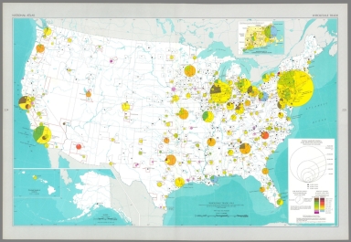
Full Title
Selected population characteristics / compiled from U. S. Bureau of the Census, Census of population: 1960, v. 1, pt. A, Washington, U. S. Govt. Print Off., 1961 -- Population density : 1960.
List No
14359.180
Note
Chart and statistical map representing the United States, featuring the geographic density of population, including for major cities, as of 1960. Map also shows political boundaries, bodies of water, coastlines and islands. Includes a legend, as well as a bar scale and scale statement. Presented with Albers Equal Area Projection. With two inset maps: Principal islands of Hawaii -- Alaska. Chart shows populations for cities, including the change in population from 1950 to 1960. Colored lithograph. Map and chart are each 20 x 31 cm, on sheet 49 x 35 cm. Map and chart appear in Special subject maps section, subsection Socio-Cultural.
Author
[Geological Survey (U.S.), U.S. Census Bureau]
Full Title
American Indian population : 1960 / adapted from U. S. Bureau of the Census, American Indians in the United States: 1960, GE-50, no. 14, Washington, U. S. Govt. Print Off., 1967, map 1:5,000,000.
List No
14359.193
Note
Statistical map representing the United States, featuring the geographic density of the indigenous population, as of 1960. Map also shows political boundaries, bodies of water, drainage, coastlines and islands. Includes a legend, as well as a bar scale and scale statement. Presented with Albers Equal Area Projection. With two inset maps: Principal islands of Hawaii -- Alaska. Colored lithograph. Map is 43 x 66 cm, on double sheet 49 x 71 cm. Appears in Special subject maps section, subsection Socio-Cultural.
Author
[Geological Survey (U.S.), U.S. Census Bureau]
Full Title
Median family income : 1959 / compiled from U. S. Bureau of the Census, County and city data book: 1962, Washington, U. S. Govt. Print Off., 1962, table 2, item 22; Census of population: 1960, PC(S1)-48, Washington, U. S. Govt. Print Off., 1965, table 3.
List No
14359.196
Note
Statistical map representing the United States, featuring the geographic density of population according to the median family income in 1959. Map also shows political boundaries, bodies of water, drainage, coastlines and islands. Includes a legend, as well as a bar scale and scale statement. Presented with Albers Equal Area Projection. With two inset maps: Principal islands of Hawaii -- Alaska. Colored lithograph. Map is 43 x 66 cm, on double sheet 49 x 71 cm. Appears in Special subject maps section, subsection Socio-Cultural.
Author
[Geological Survey (U.S.), Hirt, Howard E., Cohen, Saul B., United States. Office of Education]
Full Title
Institutions of higher education / compiled by Howard E. Hirt, Bridgewater State College and Saul B. Cohen, Clark University, 1964, revised from U. S. Office of Education, Education directory, 1964-1965, Washington, U. S. Govt. Print Off., 1965, pt. 3, p. 211-218.
List No
14359.202
Note
Statistical map representing the United States, featuring the geographic locations of higher education institutions, as of 1965. Map also shows political boundaries, bodies of water, drainage, coastlines and islands. Includes a legend, as well as a bar scale and scale statement. Presented with Albers Equal Area Projection. With twenty-nine inset maps: 1. New York City area -- 1a. New York City -- 2. Pittsburgh -- 3. Baltimore -- 4. Washington -- 5. Trenton -- 6. Philadelphia -- 7. Nashville -- 8. Atlanta -- 9. New Orleans -- 10. Chicago -- 11. San Diego -- 12. Los Angeles -- 13. San Francisco - Oakland -- 14. Portland -- 15. Denver -- 16. Minneapolis - St. Paul -- 17. Milwaukee -- 18. Kansas City -- 19. St. Louis -- 20. Cincinnati -- 21. Cleveland -- 22. Massachusetts, Connecticut & Rhode Island -- 22a. Boston -- 22b. Providence -- 23. Detroit -- 24. Buffalo -- Principal islands of Hawaii -- Alaska. Colored lithograph. Map is 43 x 66 cm, on double sheet 49 x 71 cm. Accompanying descriptive text on pages 268 and 270. Appears in Special subject maps section, subsection Socio-Cultural.
Author
[Geological Survey (U.S.), U. S. Coast and Geodetic Survey]
Full Title
Horizontal control, status as of July 1, 1968 : [United States] / adapted from U. S. Coast and Geodetic Survey, Status of horizontal control, United States, July 1, 1968, Washington, 1968.
List No
14359.239
Note
Map representing the United States, featuring horizontal control surveys in mapping, as of 1968. Shows the geographic locations of different types of horizontal control, such as adjusted and unadjusted first and second-order. Also shows political boundaries, bodies of water, drainage, coastlines and islands. Includes latitudinal and longitudinal lines, and a legend, as well as a bar scale and scale statement. With two inset maps: Principal islands of Hawaii -- Alaska. Colored lithograph. Map is 43 x 66 cm, on double sheet 49 x 71 cm. Accompanied by descriptive text here, and on page 307. Appears in Special subject maps section, subsection Mapping and charting.
Author
Geological Survey (U.S.)
Full Title
World around the United States.
List No
14359.249
Note
World map featuring the position of the United States within the globe, as of 1970. Shows political boundaries, capital cities, bodies of water, coastlines and islands. Includes concentric circles around the United States indicating distance, as well as a scale statement and explanatory notes. Presented with Azimuthal Equidistant Projection. Colored lithograph. Map is 23 x 23 cm, on sheet 49 x 35 cm. Appears in Special subject maps section, subsection World.
Author
[Geological Survey (U.S.), U.S. Census Bureau, National Geographic Society (U.S.)]
Full Title
United States exports and imports of commodities : 1967 / compiled by U. S. Bureau of the Census: U. S. exports, 1967, FT 455, annual, table 3; U. S. general imports, 1967, FT 455, annual, table 3, Washington, U. S. Govt. Print. Off., 1968. Base map by National Geographic Society, The world, 1:63,360,000; rev. by U. S. Geol. Survey, 1968.
List No
14359.251
Note
World map featuring United States exports and imports of commodities in 1967. Shows streams of commerce between the United States and other nations, national borders, bodies of water, drainage, glaciers, coastlines and islands. Includes latitudinal and longitudinal lines, as well as a legend, bar scale, scale statement and explanatory notes. With three inset charts: Total exports, by commodity group -- Total imports, by commodity group -- Exports and imports by commodity group. Presented with Van der Grinten Projection. Colored lithograph. Map is 42 x 65 cm, on double sheet 49 x 71 cm. Appears in Special subject maps section, subsection World.
Author
[Air Ministry, Great Britain. War Office, Great Britain. Ordnance Survey]
Full Title
Map showing the United States of America : Air routes in the U.S.A. shown in blue. O.R. 303. Ordnance Survey, 1926. Printed at the War Office, 1926.
List No
14344.060
Note
Map showing both existing and proposed American air routes across the United States in 1926. Shows political boundaries, cities, railways, topography, lakes, drainage, coastlines and islands. Relief shown pictorially. Includes latitudinal and longitudinal lines, as well as a legend. Colored lithograph. Map is 27 x 40 cm, on fold-out sheet 33 x 44 cm. Accompanied by descriptive text on pages 38-39.
Author
Rand McNalley & Company
Full Title
Rand McNally road map : United States.
List No
14003.010
Note
Road map of the United States, showing interstate and state highways, paved and dirt roads, ferries and boatlines. Includes legend, compass rose, time zones, and bar scale with scale statement: One inch equals approximately 131 miles. Features index to national parks and monuments. Copyright by Rand McNally & Company, Chicago, Ill. Lithographed in the U.S.A.
Author
Rand McNalley & Company
Full Title
Rand McNally : Transcontinental mileage chart of the United States.
List No
14003.053
Note
Mileage chart of United States, showing distances between cities, also displayed in chart below map. Includes compass rose and time zones. With 2 insets: Milage distances between principal cities -- Yellowstone National Park. Copyright by Rand McNally & Company, Chicago, Ill. Lithographed in the U.S.A.
Author
Vuillemin, Alexandre
Full Title
Geographie commercial et industriel : Nouvelle carte illustree de l'Amerique du Nord : indiquant les grandes divisions physiques, la distribution geographique des vegetaux et des mineraux, les ports de commerce, villes industrielles et fortifiees des differents etats. Dressee par A. Vuillemin. Gravee par Langevin. Paris, Chez Fatout, Editeur. 1857. Grave sur acier, la topographie par Gerin, le trait au burin par F. Lefevre, Les illustrations dessinees par A. Testard et gravees par Guesnu. Imp. par Mangeon. Paris. (to accompany) Atlas de geographie commercial et industriel.
List No
13375.006
Note
Engraved outline hand color map of North America. Includes 14 vignette views of different countries in North America, European colonies, and 2 sections of fruits and plants in panels at sides. Includes tables, legend and notes.
Author
Society for the Diffusion of Useful Knowledge (Great Britain)
Full Title
The United States of North America.
List No
10911.075
Author
[Pasa, Ali Seref, Esref, Hafiz Ali]
Full Title
Amerika-yi şimali = North America. 1309 (1893). Tabie ve Nnashiri Hasan Ferid. (to accompany) Yeni cografya atlasi - ىگى جغرافىا آطلسى = New geographical atlas. Dersa'adet (Istanbul), 1307-1309 (1891-1893).
List No
13621.008
Note
Map of North America. Covers Central America. Shows political and state boundaries.
Author
[Pasa, Ali Seref, Esref, Hafiz Ali]
Full Title
Jamahiria Müttefik Amerika = United States of America. 1311 (1895). Tabie ve Nnashiri Hasan Ferid. (to accompany) Yeni cografya atlasi - ىگى جغرافىا آطلسى = New geographical atlas. Dersa'adet (Istanbul), 1307-1309 (1891-1893).
List No
13621.034
Note
Map of the United States of America. Covers part of Canada and Mexico. Shows State boundaries in red.
Author
[Pawley, Neele, Samuel John, 1758-1824, Neele, George, Pinnock and Maunder]
Full Title
United States. Neele sculp. Published Jany. 1st. 1819, by Pinnock & Maunder Strand.
List No
14326.042
Note
Map of the United States and vicinity. One of the few 19th century maps to show the proposed state of Franklinia in eastern Tennessee. Shows political boundaries, cities, railroads, topography, major lakes and drainage, coastlines and islands. Features the indigenous peoples living therein, such as the Chicasaw. Relief shown with hachures. Includes latitudinal and longitudinal lines, as well as a compass rose and bar scale, given in British miles. Hand-colored engraving, including illustration of clouds behind title. Map is 22 x 27 cm, on sheet 26 x 34 cm.
Author
Silishchensky, Mitrofan Ivanovich 1878 - 1944
Full Title
Sev. Amer. Soyedinennyye shtaty, Meksika i Yuzhnaya. Kanada : Ekonomicheskaia karta. Prof. M. I. Silishchenskiy. "Geokartprom" Typo-Lithography and M.T. Dunaeva, Moscow. (to accompany) Geograficheskiy atlas Chast 1.
List No
13461.043
Note
Economic map of North. America. Covers part of Central America. Includes legend and tables.
Author
[Lizars, William Home, 1788-1859, Lizars, Daniel]
Full Title
United State of America. Published by T. Brown & W. & D. Lizars, Edinbr. (to accompany) New Edinburgh general atlas ... The maps drawn and engraved by W. & D. Lizars.
List No
13230.051
Note
Hand colored engraved map, with inset map: Island of Newfoundland. Shows political and administrative boundaries. Relief shown by hachures and pictorially. Prime meridian is Greenwich.
Author
[Chatelain Henri, 1684-1743, Gueudeville, Nicolas]
Full Title
Carte de la Nouvelle France, ou se voit le cours des grandes rivieres de S. Laurens & de Mississipi aujour d'hui S. Louis, aux environs des-quelles se trouvent les etats, païs, nations, peuples &c. de la Floride, de la Louisiane, de la Virginie, de la Marie-Lande, de la Pensilvanie, du Nouveau Jersay, de la Nouvelle Yorck, de la Nouv. Angleterre, de l'Acadie, du Canada, des Esquimaux, des Hurons, des Iroquois, des Ilinois &c. et de la grande ile de Terre Neuve : dressee sur les memoires les plus nouveaux recueillis pour l'etablissement de la Compagnie Françoise Occident. Tom. VI. No. 23. Page 90. (to accompany) Atlas Historique ... Tome VI. A Amsterdam, chez L'Honore & Chatelain Libraires. M DCC XIX (1719).
List No
13272.687
Note
Engraved folded map, depiction of the Mississippi Delta and Mobile Bay, based upon the 1699 voyage of Pierre Le Moyne d'Iberville. Shows New England and eastern Canada. Includes plan and views of Quebec in decorative cartouche. Map is filled with engraved wildlife, scenes of Indians hunting, Indian villages, numerous ships, canoes and sea monsters and notations.
Author
[Chatelain Henri, 1684-1743, Gueudeville, Nicolas]
Full Title
Carte Contenant le Royaume du Mexique et la Floride dressez sur les meilleures observations & sur les memoires les plus nouveaux. Tom. VI. No. 27. Pag. 101. (to accompany) Atlas Historique ... Tome VI. A Amsterdam, chez L'Honore & Chatelain Libraires. M DCC XIX (1719).
List No
13272.698
Note
Engraved map of North America and the West Indies, from Newfoundland and the Great Lakes to northern South America, based on de L'Isle's map of the southern part of North America. Covers New Mexico, Louisiana, from Florida through present-day Texas and the Gulf Coast region. Shows political boundaries, Indian settlements, cities, towns, ports, rivers, and notes the discoveries along the Gulf Coast and Mississippi River. Includes text. Relief shown pictorially.
Author
Vuillemin, Alexandre
Full Title
Geographie commerciale et industrielle : Nouvelle carte illustree de l'Amerique du Nord : Indiquant Les Grandes Divisions Physiques, La Distribution Geographique Des Vegetaux Et Mineraux ... Dressee par A. Vuillemin. Gravee par Langevin. Paris, Chez Fatout, Editeur. 1861. Grave sur acier, Grave: la Topographie par Gerin, le trait au burin par F. Lefevre. Les illustrations dessinees par A. Testard et gravees par Guensu. Imprime par Mangeon. Paris. (to accompany) Atlas illustre de geographie commerciale et industrielle.
List No
13376.019
Note
Engraved outline hand color map. Including 16 vignettes views showing indigenous people in North America and 2 sections of fruits and plants in panels at sides. Map shows Russian America, Utah & New Mexico extending to the Rocky Mountains, Oregon, Northwest and Indian Territories, early discoveries, including a reference to Alvaro Nunez in Texas in 1528, Cabrillo's discovery of the Pacific in 1548, Francis Drake, Lewis & Clark and Edwin James. Includes legend, tables, color coded table of European colonies in the region and notes.
Author
[Berghaus, Heinrich, 1797-1884, Sohr, Karl, Flemming, Carl]
Full Title
Californien, Oregon, Utah und Neu-Mejico. Entw. u. gez. v. F. Handtke. Druck u. Verlag v. C. Flemming in Glogau. (to accompany) Vollstandiger Universal-Handatlas der neueren Erdbeschreibung ,,, Heinrich Berghaus ... 1859.
List No
13250.128
Note
Hand colored in outline map. Includes color coded list of administrative boundaries. Relief shown by hachures. Prime meridians are Paris and Ferro.
Author
[Berghaus, Heinrich, 1797-1884, Sohr, Karl, Flemming, Carl]
Full Title
Texas. Druck u. Verlag v. C. Flemming in Glogau. (to accompany) Vollstandiger Universal-Handatlas der neueren Erdbeschreibung ,,, Heinrich Berghaus ... 1859.
List No
13250.129
Note
Hand colored in outline map, with inset" Plan der Galveston Bay. Relief shown by hachures. Prime meridians are Paris and Ferro.
Author
Baur, Carl Friedrich
Full Title
Vereinigte Staaten und Mexiko. Entworfen u. gezeichnet v. C. F. Baur. Bassermannsche Verlagshandlung in Mannheim. B. Walther lith. (to accompany) Atlas fur Handel u. Industrie, fur Kaufleute, Fabrikanten u. Gewerbetreibende ... von C.F. Baur. 1857.
List No
13199.049
Note
Color map. Includes color coded reference. Shows political and administrative boundaries, major cities, roads and shipping routes. Includes list of 24 States in Unite States and 20 Mexican States.
Author
Rand McNally and Company
Full Title
Rand McNally Junior Auto Road Map of the United States. Copyright by Rand McNally & Company. Chicago, Ill. Made in U.S.A. P.3259.
List No
4245.003
Note
Color map. Includes explanation, and alphabetical index of cities and towns, giving populations and Key to map. U.S. interstate highways shown in red. Shows U.S. inter-state highway marker. Relief shown by hachures.
Author
Clason Map Company
Full Title
In and out maps of the principal cities showing highway connections. ( Continued on page 49). Copyright by Clason Map Co. Denver.
List No
4423.003
Note
48 uncolored maps. (continued on page 49). showing roads and highway connections in major cities in the United States.
Author
Clason Map Company
Full Title
Paving and road distances on the United States highways. Showing principal through routes. Published and Copyrighted: Clason Map. Map No. R-106 A. (at head of map) Key map of planning transcontinental tours - Paved highways shown in solid lines.
List No
4423.005
Note
Uncolored map. Includes text and road legend. Relief shown by hachures.
Author
[Brion de La Tour, Louis, 1743 – 1803, Desnos, Louis Charles]
Full Title
Nouveau Mexique, Louisiane, Canada, et les Etats Unis. Par M. Brion. A Paris, chez le Sr. Desnos. A.P.D.R. 1786. (to accompany) Atlas general, civil, ecclesiastique et militaire, methodique et elementaire pour l'etude de la geographie et de l'histoire ... par M. Brion, dirige par le sr. Desnos … A Paris 1786.
List No
13129.057
Note
Engraved hand color map. Two long rivers run from California to the Rocky Mountain region. Shows American Indian settlements. Louisiana is divided into two regions, Floride, which contains all of the territory between the appellations and the Mississippi, and Louisiana proper. Relief shown pictorially. Includes note regarding explorations along the Northwest Coast of America. Includes decorative engraved title cartouche and border.
Author
[Brion de La Tour, Louis, 1743 – 1803, Desnos, Louis Charles]
Full Title
Carte Des Etats-Unis de l'Amerique Septentrionale, dressee d'apres des Cartes Anglaises; Par M. Brion. A Paris, chez le Sr. Desnos. (to accompany) Atlas general, civil, ecclesiastique et militaire, methodique et elementaire pour l'etude de la geographie et de l'histoire ... par M. Brion, dirige par le sr. Desnos … A Paris 1786.
List No
13129.061
Note
Unnumbered engraved hand color map of the United State, one of the earliest maps to name the United States (Etats Unis de L'Amerique Septentrionale. In the northwest, northwest, the "Countree des Six Nations" is depicted, as are many of the Indian territories. Includes decorative engraved title cartouche and border. Relief shown pictorially.
Author
Homann, Johann Baptist, 1663-1724
Full Title
Mississippi.
List No
12499.224
Author
[Meyer, Joseph, 1796-1856, Grassl, J.]
Full Title
Vereinigte Staaten von Nord-America : Californien, Texas und die Territorien New Mexico u. Utah. Nach den neuesten Hulfsmitteln gezeich von J. Grassl. 1852. (in upper margin) Meyer's Zeitung Atlas. No. 120. (to accompany) Neuester Zeitungs-Atlas fur Alte und Neue Erdkunde. Herausgegeben von J. Meyer.
List No
11652.098
Note
Engraved outline hand color map. Shows administrative boundaries, cities and towns, the gold region in California, Texas truncated by an enlarged New Mexico. Relief shown by hachures. Depth shown by isolines. Prime meridians are Greenwich and Washington.
Author
[Bartholomew, J.G., U.S. Signal Surface & Weather Bureau, Buchan, Alexander]
Full Title
Plate 33. Anomylous Weather & Storms - North American.
List No
12430.043
Author
Aa, Pieter van der, 1659-1733
Full Title
L'Amerique septentrionale, Suivant les nouvelles observations de Messrs ... A Leide, Chez Pierre Van der Aa. (to accompany) Nouvel Atlas, tres-exact et fort commode pour toutes sortes de personnes, Contenant les Principales Cartes Geographiques ...
List No
11691.101
Note
Full color map of North America and the West Indies. Centered on the Great lakes, covers from Baffin Bay to the Amerique Meridionale, including Florida, New Mexico, New Spain (Mexico), California, Nouvelle France, and the Hudson Bay. California is not clear whether it is an island or not. The Gulf of California is left open ended, Parts of California are identified as New Albion. The exploration routes used by d'Oliver, Cortez, and Drake are shown in dote lines to the west of Mexico. Map showing political and administrative boundaries and settlements. Relief shown pictorially. Includes decorative title cartouche.
Author
Aa, Pieter van der, 1659-1733
Full Title
La Floride, Suivant les nouvelles observations de Messrs ... A Leide, Chez Pierre Van der Aa. (to accompany) Nouvel Atlas, tres-exact et fort commode pour toutes sortes de personnes, Contenant les Principales Cartes Geographiques ...
List No
11691.102
Note
Full color map of Southern States. Covers part of Mexico, New Mexico, Texas, and Florida as far North as Illinois and Philadelphia, includes also the Carolinas, Virgina and Maryland. Map showing political and administrative boundaries, Native American settlements, major towns and villages. Relief shown pictorially. Includes decorative title cartouche.
Author
[Weiland, Carl Ferdinand, 1782 -1847, Hassel, Georg, 1770-1829]
Full Title
Geographisch-statistische und historische Charte von Mexico.
List No
12293.046
Note
Date estimated.
Author
Marmocchi, Francesco C.
Full Title
30. Stati Orientali della Unione Americana.
List No
12235.031
Author
Marmocchi, Francesco C.
Full Title
31. Stati e Territorii Occidentali della Unione Americana.
List No
12235.032
Author
Finley, Anthony
Full Title
Indiana. Young & Delleker Sc. Published by A. Finley, Philada. (to accompany) A New General Atlas Comprising a Complete Set of Maps, representing the Grand Divisions Of The Globe ... Philadelphia: Published by Anthony Finley. 1827.
List No
0282.030
Note
Full color map on sheet 35x27. Relief shown pictorially. Prime meridians are Washington and Greenwich. Shows counties, major cities, roads and rivers.
Author
U.S. Department of Agriculture, Weather Bureau
Full Title
(United States) Weather Map. January 1, 1901. Published by Authority of the Secretary of Agriculture.
List No
9734.002
Author
Moll, Herman, d. 1732
Full Title
A New and Exact Map of the Dominions of the King of Great Britain on ye Continent of North America. (insets) Carolina, Louisiana, Florida. Carolina. Charles-town. North America. Beaver activity illustration.
List No
9729.010
Note
State 6 of this map. Known as the "Beaver map" because of its depiction of beavers at work building dams with Niagara Falls in the background. This map at the time was the most detailed and largest scale map of British possessions in North America. First issued in 1715, the map went through 7 different issues to 1736.
Author
Baker, Harriet E.
Full Title
New Hampshire. (to accompany) Harriet E. Baker's Book of Penmanship & Map. At Mr. Dunham's School Windsor Vermont March 31, 1819.
List No
8307.020
Note
Outline color map by county. Showing cities and towns, and rivers.
Author
Baker, Harriet E.
Full Title
Connecticut. (to accompany) Harriet E. Baker's Book of Penmanship & Map. At Mr. Dunham's School Windsor Vermont March 31, 1819.
List No
8307.026
Note
Outline color map by county. Showing cities and towns, and rivers. Relief shown by hachures.
Author
Baker, Harriet E.
Full Title
New Jersey. (to accompany) Harriet E. Baker's Book of Penmanship & Map. At Mr. Dunham's School Windsor Vermont March 31, 1819.
List No
8307.032
Note
Outline color map by county, with decorative cartouche. Showing cities and towns, and rivers. Relief shown by hachures.
Author
Shell Oil Company
Full Title
Shell Map of the United States (cover title). Shell Highway Map of United States. 7-DD-1956-4.
List No
5840.003
Author
Burr, David H., 1803-1875
Full Title
Map of the United States Of North America With parts of the Adjacent Countries, By David H. Burr. (Late Topographer to the Post Office.) Geographer to the House of Representatives of the U.S. John Arrowsmith. Entered ... July 10th, 1839, by David H. Burr ... District of Columbia.
List No
0104.001
Note
This is the "Map of the United States of North America..." from Burr's American Atlas which consists of 13 separate sheets dissected & mounted on linen. In full color by state, country, or region. In 8 sections mounted on linen. Label on back states "No. 1. United States."
Author
Smiley, Thomas T.
Full Title
United States. (with) Eastern States.
List No
0902.004
Note
In full color by state or territory. Two inset vignettes: the signing of the Declaration of Independence and depictions of "commerce, manufacture and agriculture."
Full Title
United States. (with) New England States. Wightman Sc. Published by Lincoln & Edmands, Boston, (1819)
List No
0004.003
Note
Uncolored engraved map with inset. Relief shown pictorially. Prime meridians: London and Philadelphia.
Full Title
United States. H. Morse Sc. Published by Lincoln & Edmands, Boston. (1832)
List No
0006.003
Note
Engraved map. Outline hand col. Relief shown pictorially. Includes inset. Prime meridians: Washington and Greenwich.
Author
[Alaskan Boundary Tribunal, Vancouver, George]
Full Title
(Facsimile) A Chart Shewing Part of the Coast of N.W. America with Tracks of his Majesty's Sloop Discovery and Armed Tender Chatham .... Published May 1st, 1798 by J. Edwards, Pall Mall & G. Robinson, Paternoster Row.
List No
0009.004
Note
Surveyed during summers of 1782, 1783, and 1784. British names assigned to various reaches of coastline such as "New Norfolk" and "New Hanover." Delineates between Spanish and Russian possessions. Relief shown by sketches.
Author
[Alaskan Boundary Tribunal, Vancouver, George]
Full Title
(Facsimile) From Vancouvers Atlas - Part of Chart No. XII; Part of Chart No. VII. Photo. Lith. by A. Hoen & Co., Baltimore, MD.
List No
0009.005
Note
See Table of Contents which itemizes the two Vancouver maps omitted here because they are included as maps numbered No. 4 and No. 5 in the U.S. part of this atlas. Relief shown by sketches. Relief shown by sketches.
Author
Alaskan Boundary Tribunal
Full Title
(Facsimile) Russian Map (Enclosure in C. Bagot's Dispatch). Translation of Title: Map of Marine Discoveries by Russian Navigators in the Pacific and Frozen Oceans, made in various years.
List No
0009.006
Note
In Russian. Relief shown by sketches.
Author
Alaskan Boundary Tribunal
Full Title
(Facsimile) (Russian Map) Part of Map Numbered 5.
List No
0009.007
Note
In Russian. Relief shown by sketches. Boundaries tinted.
|


![Horizontal control, status as of July 1, 1968 : [United States].](https://www.davidrumsey.com/rumsey/Size2/RUMSEY~8~1/199/14359239.jpg)