|
Author
Clason Map Company
Full Title
Clason's Road Map of Pennsylvania. Showing paved roads, All weather roads and other throughfares. (U.S. Highways shown in red.) Published by the Clason Map Co., Chicago-Denver. Copyrighted Clason Map. All rights reserved. Map No. R-202 A.
List No
4423.013
Note
Color map. Includes road legend, and Index of cities and towns giving populations and Key to map.
Author
[Bradford, Thomas G., Goodrich, S.G.]
Full Title
Pennsylvania. Engraved by G.W. Boynton. Entered ... 1838 ... Massachusetts.
List No
4453.018
Note
In full color by county.
Author
[Bradford, Thomas G., Goodrich, S.G.]
Full Title
Philadelphia. Engraved by G.W. Boynton. Entered ... 1838, by T.G. Bradford ... Massachusetts.
List No
4453.019
Note
In full color with areas marked by either Roman numerals or cardinal numbers.
Author
Rand McNally and Company
Full Title
Rand, McNally & Co.'s Pennsylvania.
List No
4520.018
Note
In outline color. Shows named railroads. Prime meridians: Greenwich and Washington.
Author
Cram, George Franklin
Full Title
Cram's Rail Road & County Map of Pennsylvania, Maryland, New Jersey & Delaware.
List No
4533.023
Author
Lucas, Fielding Jr.
Full Title
Pennsylvania. 18. H.S. Tanner, sc. (1816)
List No
4534.018
Note
Engraved, hand colored. Counties shown. Relief shown with hachures. Meridian Philadelphia.
Author
Mitchell, Samuel Augustus
Full Title
A New Map of Pennsylvania Exhibiting Its Internal Improvements. Roads, Distances, &c. Charles Desilver, No. 714 Chestnut Street. Entered according to Act of Congress in the year 1856 by Charles Desilver in the Clerk's office if the District Court of the Eastern District of Pennsylvania. 13.
List No
4557.014
Note
Meridian Greenwich. Insets of Lehigh and Schuyland Coal Regions, and Vicinity of Philadelphia. Counties tinted in color. Relief shown by hachures.
Author
Cram, George Franklin
Full Title
New Rail Road and County Map of Pennsylvania, New Jersey, Delaware & Maryland.
List No
4558.027
Author
Mitchell, Samuel Augustus Jr.
Full Title
County map of the State of Pennsylvania. Drawn and Engraved by W.H. Gamble Philadelphia. Entered ... 1876 by S. Augustus Mitchell, . ... Washington. (with four inset maps): Harrisburg, Williamsport, Erie, and Scranton.
List No
4564.020
Note
Full colored map by county. Shows settlements, rivers, etc. Relief shown by hachures. Prime meridian is Washington.
Author
Mitchell, Samuel Augustus Jr.
Full Title
Plan of the City of Philadelphia and Camden, 1876. Drawn and Engraved by W.H. Gamble Philadelphia. Entered ... 1876 by S. Augustus Mitchell, . ... Washington.
List No
4564.021
Note
Full colored map. Shows wards, railroads, ferries, and major buildings in square feet and acres.
Author
Johnson, A.J.
Full Title
Johnson's Pennsylvania and New Jersey. Published by A. J. Johnson, New York. 42. 43. Entered according to the Act of Congress, in the year 1864, by A.J. Johnson in the Clerk's Office of the District Court of the United States for the Southern District of New York.
List No
4574.018
Note
Engraved color map with districts and counties differentiated by color. Shows roads and railroads. Alternative meridian shown is Washington D.C.
Author
Carey, Mathew
Full Title
Pennsylvania.
List No
4577.014
Note
Outline color by county.
Author
[Bourquin, Frederick, Mitchell, Samuel Augustus, Tanner, Henry S.]
Full Title
A New Map of Pennsylvania with its Canals, Rail-Roads & Distances from Place to Place along the Stage Roads. _ By H.S. Tanner. Profile of the Pennsylvania Canal (and the) Columbia Rail Road. Entered according to Act of Congress in the 1840, by H.S. Tanner - in the Clerk's Office of the Eastern District Court of Pennsylvania. 13.
List No
4578.014
Note
Lithographed. Canals, roads, place names, and railroads shown. Distances to and between destinations shown in tables. Meridian Washington. Profile of the Pennsylvania Canal and the Columbia Railroad. Relief shown with hachures.
Author
Lucas, Fielding Jr.
Full Title
Pennsylvania. B.T. Welch & Co. Sc. Published by F. Lucas Jr. Baltimore.
List No
4584.054
Note
Full color by county with mountains shown in hachures.
Author
Colton, G.W.
Full Title
Colton's New township Map Of the State Of Pennsylvania. Published by G. W & C. B. Colton & Co., New York.
List No
4587.033
Note
Prime meridians are Washington D.C. and Greenwich.
Author
Arrowsmith, John
Full Title
Upper Canada &c. By J. Arrowsmith. (Map) 41. London, Pubd. 15 Feby. 1842, by J. Arrowsmith, 10 Soho Square.
List No
4613.041
Note
In outline color. Includes all of New York and most of Pennsylvania. Townships in the Niagara District numbered and listed by name in a key.
Author
Burr, David H., 1803-1875
Full Title
Pennsylvania By David H. Burr New York. Entered ... 1834 by Illman & Pilbrow ... New York.
List No
4628.039
Note
In full color by county.
Author
[Collot, George Henri Victor, Tardieu, P.F.]
Full Title
Plan of the Town of Pittsburg. Grave par Tardieu l'aine. PL. 6.
List No
4664.005
Note
This is one of the earliest maps of Pittsburgh, showing the ruins of Fort Pitt and the replacement Fort Lafayette. Coal Mines are identified. Scale given in fathoms.
Author
[Collot, George Henri Victor, Tardieu, P.F.]
Full Title
Passage of a Branch of the river Juniata across a chain of Mountains uninhabited and covered with Wood. Grave par Tardieu l'aine. PL. 23.
List No
4664.014
Note
This probably shows one of the passages of the Juniata River through the Allegheny Mountains east of Pittsburgh. Uncolored.
Author
Cram, George Franklin
Full Title
Western Half of Pennsylvania.
List No
4727.009
Note
Prime meridians Washington D.C. and Greenwich. Relief shown by hachures. With printed color.
Author
Cram, George Franklin
Full Title
Eastern Half of Pennsylvania.
List No
4727.010
Note
Prime meridians Washington D.C. and Greenwich. Relief shown by hachures. With printed color.
Author
Cram, George Franklin
Full Title
Pennsylvania.
List No
4727.012
Note
Prime meridians Washington D.C. and Greenwich. Relief shown by hachures. With printed color.
Author
Gray, Ormando Willis
Full Title
Pennsylvania.
List No
4740.033
Note
Prime meridians Washington D.C. and Greenwich. Relief shown by hachures.
Author
[Howden, J.A., Odbert, A.]
Full Title
Railway Map of the State of Pennsylvania, 1878. Entered ... 1876 by J.A. Caldwell ... Washington. Engraved & Printed by Otto Krebs, Pittsburgh, Pa.
List No
4753.027
Author
Meyer, Joseph, 1796-1856
Full Title
Neueste Karte von Pennsylvania mit seinen Canaelen, Eisenbahnen &c. Nach den bessten Quellen bearbeitet. 1845. (with) Profil des Pennsylvania Canals, Columbia Eisenbahn. Aus der Geographischen Graviranstalt des Bibliographischen Instituts zu Hildburghausen, Amsterdam, Paris u. Philadelphia, (1860)
List No
4807.143
Note
Engraved map. State boundaries hand col. Relief shown by hachures. Includes distance tables. "Meyer's Handatlas No. 57." Prime meridians: Ferro and Washington.
Author
Meyer, Joseph, 1796-1856
Full Title
Philadelphia. Aus der Geographischen Graviranstalt des Bibliographischen Instituts zu Hildburghausen, Amsterdam, Paris u. Philadelphia, (1860)
List No
4807.145
Note
Engraved map. Includes keys to points of interest. Shows wards, churches, etc. "Meyer's Handatlas Suplm. 6, No. 106."
Author
Colton, G.W.
Full Title
Colton's Pennsylvania. Published By G. W. & C.B. Colton. No. 172 William St. New York.
List No
4825.031
Note
Counties shown in color. Prime meridians are Greenwich and Washington D.C. Relief shown by hachures.
Author
Johnson, A.J.
Full Title
Johnson's Pennsylvania and New Jersey. Published by Alvin J. Johnson & Co., New York. 42. 43. Entered according to the Act of Congress, in the year 1864, by A.J. Johnson in the Clerk's Office of the District Court of the United States for the Southern District of New York.
List No
4828.032
Note
Engraved color map with districts and counties differentiated by color. Shows roads and railroads. Alternative meridian shown is Washington D.C.
Author
Johnson, Alvin Jewett, 1827-1884.
Full Title
Johnson's Pennsylvania and New Jersey. Published by Alvin J. Johnson & Son, New York. Entered ... 1864, by A.J. Johnson ... New York. (to accompany) Johnson's New Illustrated Family Atlas Of The World ... MDCCCLXXX (1880).
List No
4830.074
Note
Engraved hand colored in outline map on 2 sheets. Shows State and county boundaries, towns, railroads, roads, rivers and canals. Depth shown by isolines. Relief shown by hachures. Prime meridians are Greenwich and Washington.
Author
Mitchell, Samuel Augustus
Full Title
A New Map of Pennsylvania with its Canals, Railroads, &c.
List No
4835.020
Author
Greenleaf, Jeremiah
Full Title
Pennsylvania.
List No
4850.039
Note
Full color by county.
Author
[Morse, Sidney E. (Sidney Edwards), 1794-1871, Breese, Samuel]
Full Title
Pennsylvania. Entered ... 1843 by Sidney E. Morse and Samuel Breese ... New York. (New York: Published by Harper & Brothers, 1845). (insets) Philadelphia, Montgomery and Delaware counties. (with) Coal Region. (to accompany) Morse's Cerographic Maps. No. III.
List No
4861.023
Note
Color wax engraved map. Shows state capital, towns, rail roads, road, waterways, canals, etc. Relief shown by hachures. Prime meridians are Greenwich and Washington.
Author
Tanner, Henry S.
Full Title
Map of the Canals & Rail Roads of Pennsylvania and New Jersey and the Adjoining States. By H.S. Tanner. American Atlas. Engraved by H.S. Turner & Assistants. Entered according to Act of Congress, in the years 1833, by H.S. tanner, in the Clerk's Office of the Eastern District of Pennsylvania. Published by H.S. Tanner, Philadelphia.
List No
4862.016
Note
Engraved. Counties differentiated by full color. Relief shown by hachures.
Author
Carey, Mathew
Full Title
The State of Pennsylvania. reduced with permission from Reading Howells Map, by Samuel Lewis. Smithers Sculp. Engraved for Carey's American Edition of Guthrie's Geography Improved.
List No
4863.033
Note
Uncolored except for small islands, Philadelphia, Lancaster, and the directional symbol.
Author
[Carey, Mathew, Warner, Benjamin]
Full Title
Pennsylvania. (Engraved by) W. Barker, sculp.
List No
4864.019
Note
Prime meridians are from London and Philadelphia. Relief shown pictorially.
Author
Carey, Mathew
Full Title
Pennsylvania. W. Barker sculp.
List No
4865.010
Note
Uncolored.
Author
Lucas, Fielding Jr.
Full Title
Pennsylvania. Drawn & Published by F. Lucas Jr., Baltimore. B.T. Welch & Co. Sc. (1822)
List No
4866.041
Note
Engraved. Colored by county. Meridian Washington. Relief shown by hachures.
Full Title
Pennsylvania and New Jersey. (with) Philadelphia and its vicinity. N. & S.S. Jocelyn Sc. (New-Haven: N. & S.S. Jocelyn. 1823)
List No
4869.005
Note
Engraved map with inset and facing index page. Outline hand color. Relief shown by hachures. Prime meridians: Washington and Greenwich.
Author
[Hinton, Isaac Taylor, 1799-1847, Simpkin & Marshall]
Full Title
Map of the states of Pennsylvania and New Jersey. (with) Plan of Philadelphia. London, published March 15, 1832 by I.T. Hinton & Simpkin & Marshall. Engraved & printed by Fenner Sears & Co. (1832)
List No
4966.013
Note
Hand col. engraved map. Relief shown by hachures. Covers also Delaware. Prime meridians: Washington and Greenwich. "92."
Author
Caldwell, Joseph A.
Full Title
Railway Map of the State of Pennsylvania, J.A. Caldwell. 1876.
List No
4974.019
Author
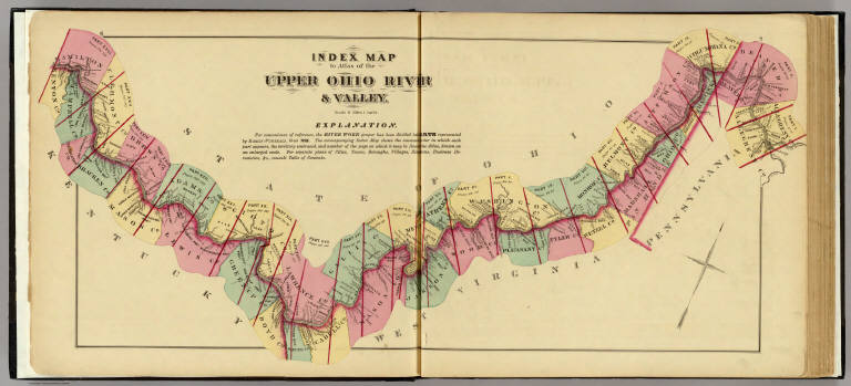
Hayes, Eli L.
Full Title
Index map to Atlas of the Upper Ohio River & Valley. (... compiled & drawn for the publishers by E.L. Hayes, assisted by E.F. Hayes, C.M. Beresford, assisted by S.A. Charpiot, F.L. Sanford, J.H. Sherman. Published by Titus, Simmons & Titus ... Phila. 1877. Eng. by Worley & Bracher ... Printed by H.J. Toudy & Co. ... Oldach & Mergenthaler Binders ...)
List No
4975.002
Note
Lithograph. Counties hand col. Includes "Explanation."
Author
Hayes, Eli L.
Full Title
Pittsburgh and Allegheny, Penna. (... compiled & drawn for the publishers by E.L. Hayes, assisted by E.F. Hayes, C.M. Beresford, assisted by S.A. Charpiot, F.L. Sanford, J.H. Sherman. Published by Titus, Simmons & Titus ... Phila. 1877. Eng. by Worley & Bracher ... Printed by H.J. Toudy & Co. ... Oldach & Mergenthaler Binders ...)
List No
4975.004
Note
Hand col. lithograph. Shows wards, etc.
Author
Hayes, Eli L.
Full Title
Upper Ohio River and Valley part I from Pittsburgh to 11 miles below 456 to 467 miles above Cincinnati. (with) Middletown, Vancefort P.O. ... (with) Riverside, Allegheny Co. ... (both) Allegheny Co., Pa. (... compiled & drawn for the publishers by E.L. Hayes, assisted by E.F. Hayes, C.M. Beresford, assisted by S.A. Charpiot, F.L. Sanford, J.H. Sherman. Published by Titus, Simmons & Titus ... Phila. 1877. Eng. by Worley & Bracher ... Printed by H.J. Toudy & Co. ... Oldach & Mergenthaler Binders ...)
List No
4975.006
Note
Hand col. lithograph. Shows buildings, landowners, townships, etc. Middletown map shows buildings with owners and lots. Riverside map shows lot numbers and major buildings.
Author
Hayes, Eli L.
Full Title
Bellevue Borough, Robella P.O. ... (with) McKee's Rocks ... (both) Allegheny Co., Penna. (... compiled & drawn for the publishers by E.L. Hayes, assisted by E.F. Hayes, C.M. Beresford, assisted by S.A. Charpiot, F.L. Sanford, J.H. Sherman. Published by Titus, Simmons & Titus ... Phila. 1877. Eng. by Worley & Bracher ... Printed by H.J. Toudy & Co. ... Oldach & Mergenthaler Binders ...)
List No
4975.008
Note
Hand col. lithograph. Shows tracts, landowners, buildings, etc. Inset of McKee's Rocks is at scale of (1:3,600) and shows lot numbers.
Author
Hayes, Eli L.
Full Title
Emsworth, Allegheny Co., Pa. (with) West Bellevue ... (with) Glenfield ... (both) Allegheny Co., Pa. (... compiled & drawn for the publishers by E.L. Hayes, assisted by E.F. Hayes, C.M. Beresford, assisted by S.A. Charpiot, F.L. Sanford, J.H. Sherman. Published by Titus, Simmons & Titus ... Phila. 1877. Eng. by Worley & Bracher ... Printed by H.J. Toudy & Co. ... Oldach & Mergenthaler Binders ...)
List No
4975.011
Note
Hand col. lithograph with 2 inset maps. Show tracts, landowners, buildings, etc.
Author
Hayes, Eli L.
Full Title
Upper Ohio River and Valley part II, 12 to 31 miles below Pittsburgh, 436 to 455 miles above Cincinnati. (with) Leetsdale, Allegheny Co., Penna. (with) Economy ... (with) Baden, Baden Borough ... (both) Beaver Co., Pa. (... compiled & drawn for the publishers by E.L. Hayes, assisted by E.F. Hayes, C.M. Beresford, assisted by S.A. Charpiot, F.L. Sanford, J.H. Sherman. Published by Titus, Simmons & Titus ... Phila. 1877. Eng. by Worley & Bracher ... Printed by H.J. Toudy & Co. ... Oldach & Mergenthaler Binders ...)
List No
4975.013
Note
Hand col. lithograph. Shows buildings, landowners, townships, etc. Inset maps variously show buildings, lots, etc. Leetsdale and Baden maps at (1:4,800) scale; Economy at (1:3,960).
Author
Hayes, Eli L.
Full Title
Sewickly Borough, Allegheny Co., Penna. (... compiled & drawn for the publishers by E.L. Hayes, assisted by E.F. Hayes, C.M. Beresford, assisted by S.A. Charpiot, F.L. Sanford, J.H. Sherman. Published by Titus, Simmons & Titus ... Phila. 1877. Eng. by Worley & Bracher ... Printed by H.J. Toudy & Co. ... Oldach & Mergenthaler Binders ...)
List No
4975.015
Note
Hand col. lithograph. Shows buildings, landowners, lots numbers, etc.
Author
Hayes, Eli L.
Full Title
Boroughs of Freedom & St. Clair, Beaver Co., Pa. (with) Philippsburg, Beaver Co., Pa. (with) Haysville, Ellanova Springs ... (with) Shousetown ... (both) Allegheny Co. ... (... compiled & drawn for the publishers by E.L. Hayes, assisted by E.F. Hayes, C.M. Beresford, assisted by S.A. Charpiot, F.L. Sanford, J.H. Sherman. Published by Titus, Simmons & Titus ... Phila. 1877. Eng. by Worley & Bracher ... Printed by H.J. Toudy & Co. ... Oldach & Mergenthaler Binders ...)
List No
4975.017
Note
Four hand col. lithographed maps on 1 sheet. Show buildings, landowners, lots numbers, etc.
Author
Hayes, Eli L.
Full Title
Beaver Borough, Beaver Co., Pa. (... compiled & drawn for the publishers by E.L. Hayes, assisted by E.F. Hayes, C.M. Beresford, assisted by S.A. Charpiot, F.L. Sanford, J.H. Sherman. Published by Titus, Simmons & Titus ... Phila. 1877. Eng. by Worley & Bracher ... Printed by H.J. Toudy & Co. ... Oldach & Mergenthaler Binders ...)
List No
4975.018
Note
Hand col. lithograph. Shows buildings, landowners, lots numbers, etc.
Author
Hayes, Eli L.
Full Title
Rochester, Beaver Co., Pa. (with) Vanport, Beaver Co., Pa. (... compiled & drawn for the publishers by E.L. Hayes, assisted by E.F. Hayes, C.M. Beresford, assisted by S.A. Charpiot, F.L. Sanford, J.H. Sherman. Published by Titus, Simmons & Titus ... Phila. 1877. Eng. by Worley & Bracher ... Printed by H.J. Toudy & Co. ... Oldach & Mergenthaler Binders ...)
List No
4975.020
Note
Hand col. lithograph with inset map. Shows buildings, landowners, lots numbers, tracts, etc.
|