|
Full Title
Second ward, Allegheny City. (1872)
List No
1811.024
Note
Hand col. lithographed map. Shows buildings, street numbers, railroad, owners of large parcels, lots, Western Penitentiary, Uniondale Cemetery, Allegheny Observatory, Humboldt Monument, etc.
Author
Hopkins, Griffith Morgan
Full Title
Third ward, Allegheny City. (1872)
List No
1811.025
Note
Hand col. lithographed map. Shows buildings, railroad, street numbers, parks, owners of large parcels, lots, etc.
Author
Hopkins, Griffith Morgan
Full Title
Allegheny City, fourth ward. From official records and actual survey, under the direction of G.M. Hopkins, civil engineer, 320 Walnut St., Philada. E. Busch, Engraver, 320 Walnut, Philada. (1872)
List No
1811.026
Note
Hand col. lithographed map. Shows buildings, street numbers, railroads, owners of large parcels, lots, East Park, South Park, etc.
Full Title
Fifth ward, Allegheny City. (1872)
List No
1811.027
Note
Hand col. lithographed map. Shows buildings, street railroads, street numbers, owners of large parcels, lots, etc. Includes inset.
Full Title
Sixth ward, Allegheny City. (1872)
List No
1811.028
Note
Hand col. lithographed map. Shows buildings, street numbers, railroads, owners of large parcels, lots, Pittsburgh Locomotive and Car Works, etc.
Full Title
Seventh ward, Allegheny City. (1872)
List No
1811.029
Note
Hand col. lithographed map. Shows buildings, street numbers, landowners, lots, James O'Hara patent, Saint Mary's Cemetery, etc.
Full Title
Homestead, on the south bank of the Monongahela River six miles out the Pittsburgh, Virginia and Charleston Railroad. Eighth ward, Allegheny City. (1872)
List No
1811.030
Note
Two hand col. lithographed maps. Homestead map shows lot numbers, McClure residence, park and railroad. Scale not given. Ward map shows buildings, street numbers, railroad, landowners, lots, Herr's Island, cemeteries, etc.
Full Title
Sharpsburg. Ninth ward, Allegheny City. (with) Allentown. (1872)
List No
1811.031
Note
Two hand col. lithographed maps with inset. Show buildings, railroads, owners of large parcels, lots, House of Refuge, U.S. Marine Hospital, etc.
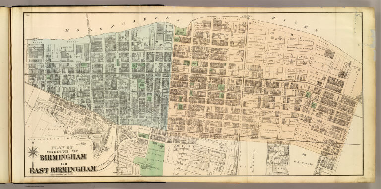
Full Title
Plan of borough of Birmingham and East Birmingham. (1872)
List No
1811.032
Note
Hand col. lithographed map. Shows buildings, street numbers, railroad, landowners, lots, etc.
Full Title
Mt. Washington. (1872)
List No
1811.033
Note
Hand col. lithographed map. Shows buildings, landowners, railroads, lots, etc.
Full Title
Temperanceville and part of Chartiers. (1872)
List No
1811.034
Note
Hand col. lithographed map. Shows buildings, owners, railroads, landowners, lots, etc.
Full Title
Borough of West Pittsburgh and Union. (1872)
List No
1811.035
Note
Hand col. lithographed map. Shows buildings, lot numbers, landowners, railroads, etc. Includes inset.
Full Title
Ormsby. (1872)
List No
1811.036
Note
Hand col. lithographed map. Shows buildings, landowners, lots, railroads, etc.
Full Title
Borough of Saint Clair and part of Lower Saint Clair. (1872)
List No
1811.037
Note
Hand col. lithographed map. Shows buildings, landowners, lots, railroad, Mt. Oliver, Bergen op Zoom Tract, etc.
Full Title
Borough of Millvale. Borough of Etna. (1872)
List No
1811.038
Note
Two hand col. lithographed maps. Show buildings, lots, landowners, railroad, Allegheny City Poor House, etc.
Author
[Cram, George Franklin, Murray-Aaron, Eugene, 1852-1941.]
Full Title
Pennsylvania. (to accompany) Cram's atlas of the world, ancient and modern : new census edition -- indexed.
List No
1910.025
Note
In full color on 2 pages. Shows administrative divisions, cities and towns, railroads, wagon roads, rives, etc. Relief shown by hachures. Prime meridian is Greenwich.
Author
Hammond, C.S.
Full Title
Pennsylvania (Northwestern Part). P3376. Pennsylvania (Southwestern Part). 531.
List No
1954.073
Author
Hammond, C.S.
Full Title
Pennsylvania (Northeastern Part). 531. Pennsylvania (Southeastern Part). 531.
List No
1954.074
Author
Bradstreet Company
Full Title
Pennsylvania. (to accompany) Bradstreet's Pocket Atlas Of The United States. Published Exclusively for Macullar, Parker & Company, Boston, Massachusetts ... New York: The Bradstreet Company, 1885. (on verso) Entered ... 1879, by The Bradstreet Company ... Washington.
List No
2054.024
Note
Full color map. Relief shown by hachures. Prime meridian is Washington, D.C.
Author
Rand McNally and Company
Full Title
Rand, McNally & Co.'s Pennsylvania.
List No
2094.028
Note
Counties outlined in color. Meridians Washington and Greenwich. Railroads highlighted. Relief shown by hachures.
Author
Bradford, Thomas G.
Full Title
Pennsylvania and New Jersey. (to accompany) A Comprehensive Atlas, Geographical, Historical & Commercial. By T.G. Bradford. Boston: American Stationers' Company. Entered ... 1835, by Thos. G. Bradford ... Massachusetts.
List No
2120.033
Note
Color map. Shows administrative boundaries, cities and towns, roads, railroads, rivers, canals, mountains, etc. Includes explanation. Relief shown by hachures. Prime meridians are Washington and London.
Full Title
Western Pennsylvania. Eastern Pennsylvania. (Published by George F. Cram, Chicago, Ill. 1909)
List No
2134.058
Note
Map in full color on 2 sheets. Relief shown by hachures. Shows counties, settlements, railroads, etc.
Author
[Breese, Samuel, 1802-1873, Morse, Sidney E. (Sidney Edwards), 1794-1871]
Full Title
Pennsylvania. (with) Philadelphia, Montgomery and Delaware counties. (with) Coal Region. Entered ... 1843 by Sidney E. Morse and Samuel Breese ... New York. (New York: Published by Harper & Brothers, 1845)
List No
2301.012
Note
Col. wax engraved map. Relief shown by hachures. Prime meridians: Greenwich and Washington.
Author
[Jones, C.H., Hamilton, T.H., Williams, J.David]
Full Title
Map of New York, Pennsylvania, and New Jersey. (inset) Long Island.
List No
2307.017
Note
Relief shown in hachures.
Author
Poussin, Guillaume Tell, 1794-1876
Full Title
Canal de la Chesapeake a l'Ohio. Plan general du trace et profil du canal. Dessine par le Major Poussin. Grave par (V.?) Adam. (1834)
List No
2329.002
Note
Engraved map with 2 insets. Relief shown by hachures.
Author
[Poussin, Guillaume Tell, 1794-1876, Town, J.]
Full Title
Plan du trace de Canal Erie et du Canal Champlain. Etat de New-York. (with) Plan du Port de Presqu'ile et du Barrage construit pour approfondir son entree. (with) Details de construction du pont de Mr. J. Town. Dessine par le Major Poussin. Grave par (V.?) Adam. (1834)
List No
2329.010
Note
Engraved map. Relief shown by hachures. Includes profile of Erie Canal and Champlain Canal and view of covered bridge.
Author
Lewis, Samuel
Full Title
Pennsylvania. Drawn by S. Lewis. Engd. by D. Fairman. (Published by John Conrad & Co., Philadelphia. 1804)
List No
2436.044
Note
Engraved map, uncolored. Relief shown by hachures. Prime meridians: Philadelphia and London.
Author
Colton, G.W.
Full Title
Colton's Pennsylvania.
List No
2441.057
Author
[Stieler, Adolf, Petermann, A.]
Full Title
Vereinigte Staaten Von Nord-Amerika In 6 Blattern, Bl. 3. Petermann. Bearbeitet v. H. Habenicht. Gest v. Eberhardt, Kuhn, Metzeroth & Weiler. Gotha: Justus Perthes. 1873.
List No
2449.090
Note
The United States in 6 sheets. Sheet 3 includes the New England States, Michigan, parts of Indiana, Ohio, and all of Pennsylvania in outline color. Two small inset maps: Boston and New and their respective environs.
Author
Goodrich, S.G.
Full Title
New York. N. Jersey, Pennsylvania, Delaware & Maryland. G. Boynton Sc. Entered ... by S.G. Goodrich of Massachusetts. (Boston: Gray & Bowen ... 1831)
List No
2468.011
Note
Two hand colored engraved maps on facing pages. Relief shown pictorially. Prime meridians: Washington and Greenwich.
Author
[Bache, A. D., Hassler, F. R.]
Full Title
(Map of Delaware Bay and River). Sheet no. 3. (Founded upon a trigonometrical survey under the direction of F.R. Hassler and A.D. Bache, Superintendents of the Survey of the Coast of the United States. Triangulation by F.R. Hassler, assts. J. Ferguson, E. Blunt, C.M. Eakin, F.H. Gerdes, J.J.S. Hassler & J.E. Johnstone, Capt. Topl. Engrs. Topography by assistants W.M. Boyce, F.H. Gerdes, J.J.S. Hassler, H.L. Whiting, G.D. Wise & B.F. Sands, U.S.N. Hydrography by the party under the command of G.S. Blake, Lieutenant U.S. Navy. Soundings outside the capes under the direction of T.R. Gedney and G.M. Bache, Lieutenants U.S. Navy. Published in 1848. A.D. Bache, Superintendent). Final reduction for engraving of topography by W.M.C. Fairfax, asstist. & of hydrography by Lt. J.B. Dale, U.S.N. & J.B. Gluck, assistant. Engraved by F. Dankworth, assisted by O.A. Lawson. Lettering by F. Dankworth & J. Knight. Electrotype copy no. 4 by G. Mathiot, U.S.C.S.
List No
2470.024
Note
Engraved nautical chart. North sheet (3 of 3). Inset: Part of the Delaware river continued from Frankford to Trenton. Relief shown by hachures; depths by soundings. Includes descriptive notes on the survey, sailing directions, tides and currents. Oriented with north toward upper left. Prime meridians: Greenwich and New York. In upper margin "Presented under authority of an act of Congress of the United States of June 3d 1844 by direction of the Treasury Department, A.D. Bache Superintendent Coast Survey."
Author
Mitchell, Samuel Augustus
Full Title
County map of the state of Pennsylvania. Drawn and engraved by W.H. Gamble, Philadelphia. Entered ... 1870 by S. Augustus Mitchell, Jr. ... Pennsylvania.
List No
2483.015
Note
Hand colored. Relief shown by hachures. Shows settlements, railroads, rivers, etc. Prime meridians: Greenwich and Washington.
Author
Mitchell, Samuel Augustus
Full Title
Plan of Philadelphia. Entered ... 1870 by S. Augustus Mitchell, Jr. ... Pennsylvania.
List No
2483.016
Note
Hand colored. Shows wards, major buildings, railroads, etc.
Author
Henshaw, Frances A.
Full Title
Pensylvania.
List No
2501.009
Note
State in outline color.
Author
Mitchell, Samuel Augustus
Full Title
A New Map of the State of Pennsylvania, Exhibiting its internal Improvements, Roads Distances &c. By J.H. Young. Philadelphia. Published by Charles Desilver, No. 251 Market Street. Entered ... 1856 by Charles Desilver ... Pennsylvania. (with two inset maps) Lehigh and Schuylkill Coal Regions, and Vicinity of Philadelphia.
List No
2514.016
Note
Full color map. Shows railroads, capitals, important towns, canals, distances, etc. Relief shown by hachures. Prime meridians are Greenwich and Washington.
Author
Mitchell, Samuel Augustus Jr., 1792-1868
Full Title
New York, New Jersey, Pennsylvania, and Delaware. (to accompany) Mitchell's New Reference Atlas for the Use of Colleges, Libraries, Families and Counting Houses. Philadelphia: Published By E.H. Butler & Co. 1865.
List No
2516.011
Note
Hand colored map. Relief shown by hachures. Showing administrative divisions, major cities, railways, rivers, lakes and mountains. Prime meridians are Greenwich and Washington.
Author
[Carey, Mathew, Lewis, Samuel]
Full Title
The State of Pennsylvania reduced with permission from Reading Howell's Map, by Samuel Lewis. Smither Sculp. Engraved for Carey's American Edition of Guthrie's Geography improved.
List No
2542.010
Note
Uncolored.
Author
Marshall, John
Full Title
A Map of the Country from Rariton River in East Jersey to Elk Head in Maryland. Shewing the several Operations of the American and British Armies, in 1776 and 1777. Engraved for Washington's Life. Plate IV. Drawn by S. Lewis from Surveys made by order of Gen. Washington. Engraved by Fs. Shallus. Published by C.P. Wayne. Philadelphia. (1807)
List No
2559.005
Note
Engraved. Folded map. Relief shown with hachures. Swamp shown.
Full Title
Philadelphia and its environs. Boston and its environs. Washington City and its environs. New-York and its environs. Charleston, S.C., and its environs. Baltimore and its environs. Entered ... 1831, by Cooke & Co. ... Connecticut. (1837?)
List No
2573.006
Note
Six engraved maps on 1 sheet.
Author
Tanner, Henry S.
Full Title
Map of Pennsylvania and New Jersey By H.S. Tanner. Published by H.S. Tanner, Philadelphia. Engraved by H.S. Tanner & Assistants. Entered ... 20th day of August 1823, by H.S. Tanner... Pennsylvania. American Atlas.
List No
2589.029
Note
In full color by county.
Author
Tanner, Henry S.
Full Title
Map of Pennsylvania and New Jersey By H.S. Tanner. Published by H.S. Tanner, Philadelphia. Engraved by H.S. Tanner & Assistants. Entered ... 20th day of August 1823, by H.S. Tanner... Pennsylvania. American Atlas.
List No
2593.026
Note
In full color by county.
Author
Bradford, Thomas G.
Full Title
Pennsylvania and New Jersey. (to accompany) A Comprehensive Atlas, Geographical, Historical & Commercial. By T.G. Bradford. William D. Ticknor, Boston. Wiley & Long, New-York. Entered ... 1835, by Thos. G. Bradford ... Massachusetts.
List No
2643.033
Note
Outline color map by administrative boundaries. Shows cities and towns, roads, railroads, rivers, canals, mountains, etc. Includes explanation. Relief shown by hachures. Prime meridians are Washington and London.
Author
Finley, Anthony
Full Title
Pennsylvania. Young & Delleker Sc. Published by A. Finley Philada.
List No
2680.018
Author
Carey, Mathew
Full Title
Pennsylvania.
List No
2721.019
Note
Outline color by county. Relief shown by hachures. Prime meridians Philadelphia and London.
Author
Lange, Henry, 1821-1893.
Full Title
Neu York, Pennsylvanien u. Neu Jersey. (with inset map) New York und Umgegend. H. Lange's Atlas v. Nord Amerika Blatt III. Braunschweig: Verlag v. George Westermann. Lith. Anst. von L. Kraatz in Berlin.
List No
2743.003
Note
Engraved map. Borders hand col. Shows roads, canals, railroads, etc. Relief shown by hachures. Scale of inset map (ca. 1:260,000)
Author
Tanner, Henry S.
Full Title
Map Of Pennsylvania And New Jersey By H.S. Tanner. Improved To 1825. American Atlas. Entered ... 20th day of August 1823, by H.S. Tanner ... Pennsylvania. Engraved by H.S. Tanner& Assistants.
List No
2755.010
Note
In full color by county.
Author
Caldwell, Joseph A.
Full Title
Railway Map of the State of Pennsylvania, J.A. Caldwell. 1877.
List No
2772.037
Author
Tanner, Henry S.
Full Title
Pennsylvania and New Jersey. (to accompany) A New Pocket Atlas of the United States With The Roads and Distances, Designed For the Use of Travelers. By H.S. Tanner. Philadelphia: Published by the Author. 1828. (on verso) ...on the seventeenth day of November ... 1828, Henry S. Tanner ... hath deposited ... a book ... Pennsylvania.
List No
2782.007
Note
Outline colored map. Prime meridian is Washington, D.C. Rare. Same maps used in Darby's View of U.S. Although this appears in Tanner's catalogues for several years after 1828, it must not have sold well, as few copies have survived. Bound with half leather and paper covered boards. "Pocket Atlas" embossed on spine.
Author
Rand McNally and Company
Full Title
Pennsylvania (Western Section).
List No
2790.059
Author
Rand McNally and Company
Full Title
Pennsylvania (Eastern Section).
List No
2790.061
|