|
Author
Hughes, William, 1818-1876
Full Title
Industrial map of the British Islands exhibiting the chief localities of manufacturing and commercial industry : With the ratio of population in the different counties, and the towns classified according to their respective populations. By W. Hughes, F.R.G.S. George Philip & Son, London & Liverpool.
List No
14487.008
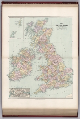
Note
Map representing industry in the British Isles. With two ancillary maps: Map showing the distribution of the chief mineral productions of The British Islands. -- Map showing the comparative density of population in the different parts of the British Islands. Maps show county boundaries, railways, cities, bodies of water, canals, drainage, coastlines, and islands. Maps include latitudinal and longitudinal lines, as well as a legend and bar scales given in English miles and kilometers. With one inset map: Shetland Isds. Colored lithograph. Together, maps are 61 x 51 cm, on double sheet 70 x 56 cm. With handwritten annotations in red.
Author
Spruner von Merz, Karl, 1803-1892
Full Title
Britannia et Hibernia. Gothae : Justus Perthes. (to accompany) C. Spruneri atlas antiquus No. VII. Editio secunda ... Anno MDCCCLV (1855). (half title page) Dr. Karl von Spruner's Historisch-geographischer Hand-Atlas ... (insets) Britannia Ptolemaei. (with) Britannia Strabonis. (with) Hadriani murus.
List No
11676.014
Note
Outline hand colored map of Great Britain. Shows political and admnistrative divisions, major cities and towns. Relief shown by hachures. Includes British colonies.
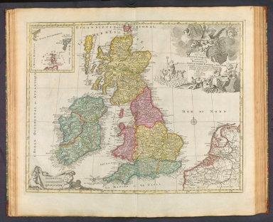
Author
Elwe, Jan Barend
Full Title
Les Isles Britanniques qui contiennent les Royaumes d'Angleterre, Escosse, et Irlande distingués en leurs principales provinces subdivisées en leurs Shireries ou Comté composé selon les plus nouvelle observations des meilleurs geographes. Publiée par Jan Bt. Elwe. A Amsterdam. MDCCXCII.
List No
14478.022
Note
Map of the British Isles and vicinity. Shows countries, regions, cities, topography, bodies of water, drainage, coastlines and islands. Relief shown pictorially. Includes a compass rose with north oriented toward top of sheet, three bar scales, latitudinal and longitudinal lines. Inset map: La Mer d'Escosse [= The Sea of Scotland]. With a decorative cartouche and vignettes. Hand-colored engraving. Map is 46 x 58 cm, on double sheet 58 x 70 cm.
Author
[Weekly Dispatch, Davies, B. R.]
Full Title
The British Isles / by B. R. Davies ; drawn and engraved by B. R. Davies, 16 George Str. Euston Squ. ; E. Weller Lithogr.
List No
14360.009
Note
Map of the British Isles and vicinity. Shows political boundaries, counties, cities, railways (in use and under construction), topography, bodies of water, drainage, coastlines, islands, submarine telegraph lines and distances. Relief shown with contour lines. Includes latitudinal and longitudinal lines, as well as a legend and two bar scales, given in British statute and geographical miles. Hand-colored lithograph. Map is 65 x 43 cm, on double sheet 69 x 48 cm. Plate number handwritten in ink at upper left corner of each sheet; "22/4/60" in pencil at bottom of sheet. Appears in Vol. I : British.
Author
[Ptolemy, Claudius, D'Angelo, Jacopo, Regiomontanus, Joannes, Pirckheimer, Willibald, Grueninger, Johann]
Full Title
(Tabula I Europae )
List No
10891.007
Author
[Morden, Robert, approximately 1650-1703, Cockerill, Thomas, active 1674-1702]
Full Title
(Text Page to) Of Europe (2) -- Of the British Isles (1).
List No
14323.015
Note
On left - descriptive text for map, Europe, on prior page (9). Text spans pages 9-12. In addition, on left - map of the British Isles. Map includes title cartouche: England, Scotland & Ireland, by Robt. Morden. Shows political boundaries, cities, topography, drainage, coastlines and islands. Relief shown pictorially. Contains latitudinal and longitudinal lines. Map is 10 x 13 cm, on sheet 15 x 20 cm. With inset map featuring two of the Channel Islands: [Guernsey and Jersey]. On right - descriptive text for map, England, Scotland & Ireland. Text spans pages 13-28.
Author
[France. Ministère des travaux publics. Administration des routes, France. Direction des cartes, plans et archives et de la statistique graphique, École nationale des ponts et chaussées (France)]
Full Title
Iles Britanniques. 2e Série. Pl. III. Ministère des Travaux Publics. Ecole des Ponts et Chaussées. Lith. A. Simon, 13, R. du Val-de-Grâce. Paris.
List No
14306.038
Note
Map showing the ports of the British Isles, in 1886, comparing the magnitude of imports to France from around the Isles. Features lakes, drainage, coastlines and islands. Includes data visualization. Lithograph in black, white and blue. Map is 27 x 22 cm, on sheet 33 x 25 cm. Appears in Deuxième livraison.
Author
Willdey, George
Full Title
To His Sacred and most Excellent Majesty George By the Grace of God King of Great Britain, France & Ireland &c. : This Map of Great Britain and Ireland Corrected from the Newest & most Exact Observations is most humbly dedicated by ... George Willdey 1715.
List No
13539.010
Note
Engraved hand color in outline map, with uncolored decorative cartouches. Includes dedication text and insets: map of The Island of Sheltand, and part of Shetland Is., with Royal coat of arms, Portrait of Georgius I.us D.G. Magniae Britaniae Franc. et Hib. Rex, View of sailing ships and boats, ship with poem to King George. Includes annotations, compass rose and explanation.
Author
[Chatelain Henri, 1684-1743, Gueudeville, Nicolas]
Full Title
Carte pour l'introduction a l'Histoire d'Angleterre ou l'on Voit son Premier Gouvernement et l'etat abrege de cette Monarchie sous les Empereurs Romains, et sous les Rois Saxons. Carte De La Grande Bretagne Sous La Domination Des Empereurs Romains. Tome 2. No. 42. (to accompany) Atlas Historique ... Seconde partie. Tome III. A Amsterdam, chez L'Honore & Chatelain. M DCC XX (1720).
List No
13272.243
Note
Engraved folded map of Great Britain under Roman occupation, with inset map: Carte D'Angleterre Sous La Domination Des Rois Saxons. Map is surrounded by the portraits of the Saxon Kings and Queens of England. Includes descriptive text and tables. Relief shown pictorially. Vol. 2 called "Tome II, Premiere partie". Vol. 3 called "Tome II, seconde partie."
Author
[Chatelain Henri, 1684-1743, Gueudeville, Nicolas]
Full Title
Nouvelle carte d'Angleterre, d'Ecosse et d'Irlande : avec des instructions pour connoitre les differents etats de la couronne d'Angleterre en Europe, Asie, Afrique, et Amerique. Tome 2.No. 43. (to accompany) Atlas Historique ... Seconde partie. Tome III. A Amsterdam, chez L'Honore & Chatelain. M DCC XX (1720).
List No
13272.244
Note
Engraved folded map of the British Isles, with inset maps of the Eastern and Western Hemispheres "Mappe-Monde ou partie du globe pour faire connoitre les etats de l'Angleterre dans l'Amerique". "Mappe-Monde pour connoitre les etats de l'Angleterre en Europe, en Asie et en Afrique". Includes descriptive text, tables and coats of arms for England, Ireland, Scotland and Wales. Vol. 2 called "Tome II, Premiere partie". Vol. 3 called "Tome II, seconde partie."
Author
Sanson, Nicolas, 1600-1667
Full Title
Isles Britanniqves. P. N. Sanson le fils. (to accompany) L'Evrope. Dediee a Monseigneur. Monseigneur le Tellier, secret. d'estat &c. Par N. Sanson le fils Geographe du Roy. A Paris chez l'autheur avec privilege pour 20 ans.
List No
11573.007
Note
Copper engraved double page, hand colored in outline map, with decorative cartouche. Showing political divisions, major cities, towns, villages, rivers, mountains, drainage, etc. Relief shown pictorially.
Author
[Brockhaus, F.A., Leeder, Ehrenfried, Leutemann, Heinrich]
Full Title
Grossbritannien und Ireland.
List No
6819.058
Note
Lavishly illustrated around margins of map with high quality vignettes of animals, structures and people. Relief shown in hachures.
Full Title
British Isles. (with) Shetland Isles. Withington sculp. (Published by Lincoln & Edmands, 1819)
List No
0004.006
Note
Uncolored engraved map with inset.
Full Title
British Isles. Asia. H. Morse Sc. Published by Lincoln & Edmands, Boston. (1832)
List No
0006.008
Note
Two engraved maps on 1 sheet. Outline hand col. Relief shown pictorially. Includes inset of Shetland Isles.
Author
Appleton, D. & Co.
Full Title
British Isles. Copyright 1891 by Appleton & Co.(to accompany) The Library Atlas Of Modern Geography ... New York, D. Appleton And Company 1892. (on upper margin) British Isles 13.
List No
0026.020
Note
Color map on 2 sheets. Shows political and administrative divisions, major cities, rivers, mountains, roads, railways, principal steam routes and distances from place to place. Includes " Divisional maps". Relief shown by hachures. Prime meridian is Greenwich.
Author
Arrowsmith, Aaron
Full Title
United Kingdoms of Great Britain and Ireland. From Arrowsmith's map of the British Isles. Hooker sc. (Boston: Published by Thomas & Andrews. 1812)
List No
0028.004
Note
Engraved map, uncolored. Relief shown by hachures. Shows cities, rivers, etc.
Author
Brue, Adrien Hubert, 1786-1832
Full Title
Carte des Iles Britanniques anciennes par A. Brue ... Carte de la Germanie ancienne, de la Rhetie, de la Pannonie et du Norique par A. Brue, Geographe du Roi ... Paris, 1827. Chez l'Auteur, rue des Macons-Sorbonne, no. 9, et chez les principaux m(archan)ds de cartes geographiques.
List No
0096.011
Note
Two hand colored engraved maps. Relief shown by hachures. Scale of Germanie ancienne is ca. 1:5,200,000. Prime meridian: Paris.
Author
Brue, Adrien Hubert, 1786-1832
Full Title
Carte generale des Iles Britanniques ou Royaume-Uni de la Grande Bretagne et de l'Irlande, par A. Brue, Geographe du Roi. Paris, 1828. Chez l'Auteur, rue des Macons-Sorbonne, no. 9, et chez les principaux marchands de cartes geographiques.
List No
0096.024
Note
Hand colored engraved map. Relief shown by hachures. Prime meridian: Paris. Includes inset.
Author
Cornell, S. S. (Sarah S.)
Full Title
British Isles. Designed to accompany Cornell's High school geography. Entered ... 1855, by S.S. Cornell ... Southern District of New York. New York: D. Appleton & Co., 443 & 445 Broadway. (1864)
List No
0197.021
Note
Engraved map. Hand colored. Relief shown by hachures. Prime meridians: Greenwich and Washington.
Author
Delamarche, Felix
Full Title
Iles Britanniques ... 1824.
List No
0231.007
Author
[Diercke, Carl, Gaebler, Eduard]
Full Title
Britische Inseln. (to accompany) Diercke Schul-Atlas fur hohere Lehranstalten. "25" on the lower right margin.
List No
0243.063
Note
Ten color map on 2 pages. Relief shown by hachures. Prime meridian is Greenwich.
Author
[Diercke, Carl, Gaebler, Eduard]
Full Title
Britische Inseln. Diercke u. Gaebler, Schulatlas fur hohere Lehranstalten. Druck und Verlag : Braunschweig, George Westermann. (to accompany) Diercke Schul-Atlas fur hohere Lehranstalten.
List No
0243.064
Note
Color map on 2 pages. Relief shown by hachures. Prime meridian is Greenwich.
Author
[Dower, John, Higgins, W.M.]
Full Title
British Isles.
List No
0247.018
Author
Duval, Henri
Full Title
Atlas Universel. Tableau historique et geographique des Iles Britanniques. ... Par Henri Duval, Chevalier de la Legion d'honneur, Professeur d'histoire, de geographie, de belles-lettres, &. Paris (1834), Chez l'Auteur, rue de la Chaussee d'Antin, No.15... Johanneau, Rue du Coq. No. 8 bis. ,,, Ate. Foucher.
List No
0254.008
Note
Map of the British Isles with chronologies of historic events. Hand tinted text to match mapped areas. Timelines include reigns of French kings for comparative reference. Relief shown with simple hachures.
Author
[Fairchild, Lucy, Fitch, George W.]
Full Title
British Islands. Drawn by (to be filled in. By George W. Fitch. New York: Sheldon, Blakeman and Company, 115 Nassau Street. Entered ... 1850, by Huntington and Savage ... New York)
List No
0289.009
Note
Printed map form with title, grid lines and numbers or "mapping plate." Map data added including relief by hachures in pen-and-ink by Lucy Fairchild.
Author
[Gaultier, abbe (Aloisius Edouard Camille), 1746?-1818, Wauthier, J. M.]
Full Title
A plain map or emblematic chart for the geographical game of the British Islands, according to the method of the Abbe Gaultier. By Mr. Wauthier, his pupil. 1797. Hewitt Sc.
List No
0294.001
Note
Engraved map. Hand colored. Relief shown pictorially. Shows boundaries, rivers, canals, lakes, capes, mountains, forests, mineral waters, cities, ports and bays.
Author
[Gaultier, abbe (Aloisius Edouard Camille), 1746?-1818, Wauthier, J. M.]
Full Title
A map of the British Isles, according to the method of the Abbe Gaultier, by Mr. Wauthier, his pupil. 1799.
List No
0294.002
Note
Engraved map. Hand colored. Shows counties, settlements, etc. Prime meridian: Ferro.
Author
Gray, O.W.
Full Title
British Isles. (inset) Shetland and Orkney Islands.
List No
0312.063
Full Title
British Islands. J.H. Young Sc. (Philadelphia: John Grigg, No. 9 North Fourth Street. 1830)
List No
0315.017
Note
Engraved map. Full hand color. Relief shown pictorially.
Author
Johnston, Alexander Keith
Full Title
The Mountains, Table Lands, Plains & Valleys of the British Isles.
List No
0370.018
Author
[Forbes, Edward, 1815-1854, Johnston, Alexander Keith, 1804-1871]
Full Title
Geological & palaeontological map of the British Islands. By A.K. Johnston, F.R.G.S. From the sketches & notes of Professor Edward Forbes, F.R.S. of Kings College London & of the Government School of Mines, President of the Geological Society. Engraved by W. & A.K. Johnston. William Blackwood & Sons, Edinburgh & London. 1st March 1854, (1856)
List No
0372.005
Note
Col. lithographed map. Northern half covering Scotland and parts of Ireland, Northern Ireland and England. Explanation on pl. 6. Includes inset of the Shetland Islands, tables, and illustrations of "Palaeozoic fishes," "Tertiary & post Tertiary Mamallia," and "Secondary reptiles." "Geology no. 5."
Author
[Forbes, Edward, 1815-1854, Johnston, Alexander Keith, 1804-1871]
Full Title
Palaeontological map (British Islands. By A.K. Johnston, F.R.G.S. From the sketches & notes of Professor Edward Forbes, F.R.S. of Kings College London & of the Government School of Mines, President of the Geological Society). Engraved by W. & A.K. Johnston. William Blackwood & Sons, Edinburgh & London. 1st March 1854, (1856)
List No
0372.006
Note
Col. lithographed map. Southern half of "Geological & palaeontological map of the British Islands." Covers Wales and most of England and Ireland. Shows 25 geologic units. Includes notes, tables and illustrations: Types of groups of Ammonites ... after Von Buch & D'Orbigny." "Geology no. 6."
Author
[Forbes, Edward, 1815-1854, Johnston, Alexander Keith, 1804-1871]
Full Title
(Composite of) Geological & palaeontological map of the British Islands. By A.K. Johnston, F.R.G.S. From the sketches & notes of Professor Edward Forbes, F.R.S. of Kings College London & of the Government School of Mines, President of the Geological Society. Engraved by W. & A.K. Johnston. William Blackwood & Sons, Edinburgh & London. 1st March 1854, (1856)
List No
0372.007
Note
Col. lithographed map on 2 sheets. Southern sheet entitled: Palaeontological map. Shows 25 geologic units. Includes inset of the Shetland Islands, notes, tables, and illustrations of "Palaeozoic fishes," "Tertiary & post Tertiary Mamallia," and "Secondary reptiles, " and "Types of groups of Ammonites ... after Von Buch & D'Orbigny." "Geology no. 5. ... no. 6."
Author
[Johnston, Alexander Keith, 1804-1871, Russell, J. Scott (John Scott), 1808-1882]
Full Title
Tidal chart of the British Seas. Showing the progress of the wave of high water, the hour of high water in Greenwich time at new and full moon; and the depth of the sea. Constructed under the direction of J. Scott Russell, Esqr., F.R.S., ED. by A.K. Johnston, F.R.G.S. Engraved by W. & A.K. Johnston. William Blackwood & Sons, Edinburgh & London. 1 Nov. 1854. (1856)
List No
0372.016
Note
Hand col. lithograph. Depths shown by bathymetric tints. "Hydrology no. 4."
Author
Johnston, Alexander Keith, 1804-1871
Full Title
Hyetographic or rain map of Europe with an enlarged rain map of the British Isles by A.K. Johnston, F.R.S.E. Engraved by W. & A.K. Johnston. William Blackwood & Sons, Edinburgh & London. (1856)
List No
0372.022
Note
Col. lithographed map. "Meteorology no. 4."
Author
[Johnston, Alexander Keith, 1804-1871, Kombst, Gustaf]
Full Title
Ethnographic map of Great Britain and Ireland, according to Dr. Gustaf Kombst ... by A.K. Johnston, F.R.G.S. Engraved & printed in colours by W. & A.K. Johnston, Edinburgh. William Blackwood & Sons, Edinburgh & London. (1856)
List No
0372.034
Note
Col. lithographed map. Relief shown by hachures. Shows also ancient British tribes. Includes inset map of the Orkney and Shetland islands. "Phytology & zoology no. 10."
Author
Rocque, John
Full Title
(A map of the Kingdom of Ireland, divided into provinces, counties and baronies. Southern section. Shewing the archbishopricks, bishopricks, cities, boroughs, market towns, villages, barracks, mountains, lakes, bays, rivers, bridges, ferries, passes, also the great, the branch & the by post roads together with the inland navigation, by J. Rocque, Chorographer to His Majesty). London, printed for Robt. Sayer, opposite Fetter Lane, Fleet Street, (1790?)
List No
0411.015
Note
Engraved map printed on 2 sheets comprising the southern half of a 4-sheet map. Counties in outline color. Shows classified roads with distances, etc. Relief shown pictorially. Inset map: The sea coasts of Great Britain and Ireland (scale ca. 1:5,800,000). Has ornamental cartouche and historical note. David Rumsey Collection sheets mounted together as 1 sheet.
Author
Rocque, John
Full Title
(Composite map) A map of the Kingdom of Ireland, divided into provinces, counties and baronies. Southern section. Shewing the archbishopricks, bishopricks, cities, boroughs, market towns, villages, barracks, mountains, lakes, bays, rivers, bridges, ferries, passes, also the great, the branch & the by post roads together with the inland navigation, by J. Rocque, Chorographer to His Majesty. London, printed for Robt. Sayer, opposite Fetter Lane, Fleet Street, (1790?)
List No
0411.016
Note
Engraved map printed on 4 sheets. Counties in outline color. Shows classified roads with distances, etc. Relief shown pictorially. Inset map: The sea coasts of Great Britain and Ireland (scale ca. 1:5,800,000). Has ornamental cartouche and historical note. David Rumsey Collection sheets mounted together as 2 sheets. (W 11--W 5 40/N 55 20--N 51 08)
Full Title
Les royaumes d'Angleterre, d'Ecosse et d'Irelande. Avec privil. (A Paris, chez Delamarche, Geogr., ca. 1800)
List No
0421.013
Note
Engraved map. Outline hand coloring. Relief shown pictorially. Includes inset of the Shetland and Orkney islands. Prime meridian: Ferro.
Author
Lizars, Daniel
Full Title
British Islands. Published by D. Lizars, Edinburgh. (1831?)
List No
0436.007
Note
Hand colored engraved map. Relief shown by hachures. Shows settlements, counties, roads and rivers.
Author
Lizars, William Home, 1788-1859
Full Title
British Islands. Published by W.H. Lizars, Edinburgh. (to accompany) Lizars' Edinburgh Geographical General Atlas ... 1841.
List No
0438.014
Note
Double page engraved hand colored in outline map. Relief shown by hachures. Shows political and administrative boundaries, cities, roads, rivers and mountains. Prime meridian is London.
Author
Malte-Brun, Conrad, 1775-1826
Full Title
Carte Physique et Mineralogique des Isles Britanniques presentus les Bassins, les principales Montagnes, les Cours d'Eau, les Roches, et les substances Minerales. 1832. Grave par Thierry.
List No
0458.024
Note
Engraved map. Geologic units listed and described in legend and depicted in full color. Major relief depicted with hachures. Rivers, lakes, islands, and basins shown. Includes 2 scales.
Author
[Martin, R.M., Tallis, J. & F.]
Full Title
The British Isles. (with) inset map of the Shetland Islands. The Illustrations by John Salmon & Engraved by Robt. Wallis. The Map Drawn & Engraved by J. Rapkin.
List No
0466.007
Note
In outline color by county with drawings of London, Edinburgh, and Dublin. The border is topped by a crown and surrounded by English roses
Author
[Desbuissons, L.E., Migeon, J.]
Full Title
Les Britannique. Grave par L. Smith. Dresse Sous La Direction De J. Migeon Par Ch. Lacoste. Migeon, editeur, imp, r. du Moulin Vert, Paris. Ecrit par A. Bizet. (1892). Fillatreau del. and Barbier sc. (for vignette).
List No
0507.025
Note
Full color by department. Relief shown by hachures. Vignette of London. Inset of Shetland Isles.
Author
[Morse, Charles W., Colby, Charles A.]
Full Title
British Isles.
List No
0623.048
Full Title
South America. J.W. Barber sc. (with) British Isles. (Published by Richardson & Lord. Sold also by Collins & Hannay, New-York, 1828)
List No
0627.003
Note
Engraved map with inset. Hand colored. Relief shown by hachures.
Full Title
Africa. J.W. Barber sc. (with) Outline of British Isles. (with) Outline of Europe. (Published by Richardson & Lord. Sold also by Collins & Hannay, New-York, 1828)
List No
0627.007
Note
Engraved map with 2 inset outline maps. Hand colored. Relief shown by hachures.
Author
Philip, George
Full Title
The Irish Channel. George Philip & Son, Ltd. The London Geographical Institute. (to accompany) Philips' Mercantile Marine Atlas. Second Edition ... 1905.
List No
0724.013
Note
Double page colored map, with insets: Belfast; The Clyde; Dublin Bay; Barrow; Cork Harbour; Cardiff; Barry; Bristol. Shows political divisions, towns, populations, mail routes, steamship routes, distances, principal railways, telegraph cables, navigable waters, canals, lighthouses, harbors, British and American consular offices, naval stations, dockyards, etc. Depth shown by gradient tints and soundings. Includes reference to general map.
Author
Philip, George
Full Title
Eastern ports of Great Britain. George Philip & Son, Ltd. The London Geographical Institute. (to accompany) Philips' Mercantile Marine Atlas. Second Edition ... 1905.
List No
0724.014
Note
Double page colored map, with insets: Manchester Ship Canal; The Tay ports; Liverpool docks; Edinburgh District; The Tyne ports; The Hartlepools; Sunderland; Hull docks; Great Grimsby. Shows political divisions, towns, populations, mail routes, steamship routes, distances, principal railways, telegraph cables, navigable waters, canals, lighthouses, harbors, British and American consular offices, naval stations, dockyards, etc. Depth shown by gradient tints and soundings. Includes reference to general map.
Author
Pinkerton, John, 1758-1826
Full Title
British Isles. (with inset map) Shetland Islands. Neele sc. 352 Strand London: published Novr. 15th. 1812, by Cadell & Davies, Strand, & Longman, Hurst, Rees, Orme, & Brown, Paternoster Row.
List No
0732.006
Note
Engraved map. Full hand col. Relief shown by hachures. "Pinkerton's modern atlas."
Author
Polish Army Topography Service
Full Title
The British Isles. Pergamon World Atlas. Pergamon Press, Ltd. & P.W.N. Poland 1964. Sluzba Topograficzna W.P.
List No
0737.087
Note
Over 20 small maps and graphics including industry, inland transport, agriculture, minerals, population, port traffic, land use, climate, employment, and foreign trade.
Author
Raisz, Erwin
Full Title
The British Isles. (to accompany) Atlas Of Global Geography. By Erwin Raisz. Lectures in Cartography, Institute Of Geographical Exploration, Harvard University, Cambridge, Mass. ... Global Press Corporation, Publishers. New York, N.Y. Sole Distributors: Harper & Brothers, New York. (on verso) Copyright 1944, by Global Press Corporation.
List No
0744.022
Note
Color maps. Accompanied by text, illustrated colored references and British emblem. Relief shown pictorially. With paper dust jacket. On the jacket it states that this is an "entirely new kind of atlas - A beautiful and informative book of 'global' maps, giving a plane's-eye view of tomorrow's geography..."
Full Title
Charte von Grossbritanien. Nurnberg, bei F. Campe. (1822)
List No
0844.010
Note
Map with outline hand coloring. Relief shown by hachures. Prime meridian: Greenwich (but numbering is incorrect: there is no "0").
Author
Society for the Diffusion of Useful Knowledge (Great Britain)
Full Title
The British Isles. Published under the superintendence of the Society for the Diffusion of Useful Knowledge, 59 Lincolns Inn Fields, April 1842, by Chapman & Hall 186 Strand. J. & C. Walker sculpt. (1844)
List No
0890.011
Note
Engraved map. County boundaries hand col. Relief shown by hachures.
Author
[Murchison, Roderick Impey, Sir, 1792-1871, Society for the Diffusion of Useful Knowledge (Great Britain)]
Full Title
Geological map of England and Wales. Published under the superintendence of the Society for the Diffusion of Useful Knowledge. 1843. Arranged by Roderick Impey Murchison ... S.P. Woodward del. Col(oure)d. by T. Malby. J. & C. Walker sculpt. Published by Chapman & Hall 186 Strand Decr. 15th. 1843. (1844)
List No
0890.012
Note
Engraved map. Geologic units hand col. Also shows railroads, canals, navigable rivers and dip of strata.
Author
[Andriveau-Goujon, J., Soulier, E.]
Full Title
Iles Britanniques. (inset) Iles Shetland. Atlas Elementaire Simplifie. Publie par J. Andriveau-Goujon. A Paris, chez Andriveau-Goujon, Editeur, Rue du Bac, No. 17.
List No
0940.024
Note
Relief shown by hachures. Paris prime meridian.
Author
Stanford, Edward
Full Title
A stereographical map of the British Isles. (inset) Orkney and Shetland Islands.
List No
0949.016
Note
Shaded relief.
Author
Stanford, Edward
Full Title
A hydrographical map of the British Isles. (inset) Diagram showing the comparative fall of the principal rivers of the British Isles.
List No
0949.017
Note
Full color. Relief shown by spot heights. Shows system of drainage, river basins with square miles, main streams, fishing stations, canals, etc. Includes explanation.
Author
[Stanford, Edward, Woodward, H.B.]
Full Title
Geological Map of the British Isles by Edward Best. Edward Best, Geological Survey.(in set) Orkney and Shetland Islands.
List No
0949.018
Note
Shows 27 geologic units.
Author
[Stanford, Edward, Woodward, H.B.]
Full Title
A County Map of the British Isles. (inset) Orkney and Shetland Islands.
List No
0949.019
Note
Shows 27 geologic units.
Author
Stanford, Edward
Full Title
A Parliamentary Map of the British Isles showing the electoral divisions as described in the Redistribution of Seats Act, 1885. (inset) Orkney and Shetland Islands. Parliamentary Boroughs within the County of London.
List No
0949.020
Author
Stanford, Edward
Full Title
A Railway Map of the British Isles. (inset) Orkney and Shetland Islands.
List No
0949.021
Note
Full color. Includes inset of the Orkney and Shetland islands.
Author
Stanford, Edward
Full Title
The Monthly Rainfall and Air Temperature of the British Isles. Alexander Buchan, F.M.S. &c.
List No
0949.022
Note
Twelve maps, each including an inset of Shetland. Includes text.
Author
[Stieler, Adolf, Petermann, A.]
Full Title
Stieler's Hand-Atlas ... No. 15a. Die Britischen Inseln und das Umliegende Meer. (insets) London. Crystall Palast. Helgoland. Rockall (View).
List No
0960.021
Note
Includes marine bathymetry.
Author
[Stieler, Adolf, Vogel, C., Koffmahn, O.]
Full Title
Nr. 36. Die Britischen Inseln. (inset) London. Die Kanal oder Normannischen Inselen.
List No
0962.083
Author
Thomson, John
Full Title
British Isles. Drawn & engraved by Hewitt, Broad Str., Bloomsby. Drawn & engraved for Thomson's New general atlas, May 1st, 1815.
List No
1007.010
Note
Engraved map. Hand colored. Relief shown by hachures. Includes inset of Orkney and Shetland islands.
Author
[Martin, R.M., Tallis, J. & F.]
Full Title
The British Isles. (with) inset map of the Shetland Islands. The Illustrations by John Salmon & Engraved by Robt. Wallis. The Map Drawn & Engraved by J. Rapkin.
List No
10095.009
Note
In outline color by county with drawings of London, Edinburgh, and Dublin. The border is topped by a crown and surrounded by English roses
Full Title
British Isles. (with) The Channel Islands. (with) The Shetland Islands. (Published at the office of "The Times," London, 1895)
List No
1010.010
Note
Color map with 2 insets. Shows railways, settlements, counties, etc. Relief shown by hachures and spot heights.
Author
[Touring club italiano, Funk & Wagnalls Company.]
Full Title
Gran Bretagna, Great Britain. Propr. Artistico-letteraria del T.C.I. Ufficio cartografico del T.C.I. (1929)
List No
1012.023
Note
Color map. Relief shown by hachures and spot heights; depths by isolines. Includes insets at 1:250,000 scale of the London, Plymouth, Edinburgh and Liverpool regions and at 1:500,000 of the Channel Islands.
Author
Society for the Diffusion of Useful Knowledge (Great Britain)
Full Title
The British Isles.
List No
10911.011
Author
Andriveau-Goujon, J.
Full Title
Carte generale des Iles Britanniques Contenant L'Angleterre, L'Ecosse Et Irlande Indiquant les principales Routes, les Canaux de Navigation, &c. Dressee d'apres les carte les plus recentes par J. Andriveau. Paris, Chez J. Andriveau-Goujon ... 1831. (inset) Iles Shetland. (to accompany) Atlas de choix ou Recueil de cartes de geographie ancienne et moderne.
List No
11124.018
Note
Double page outline hand color engraved map of Great Britain. Shows administrative boundaries, towns, roads, railroads, postal routes, rivers, lakes, canals, etc. Relief shown by hachures. Includes explanation to symbols. Prime meridian is Paris.
Author
Wells, Edward, 1667-1727
Full Title
A new map of the Brittish Isles shewing their antient people, cities, and towns of note, in the time of the Romans. Sutton Nicholls sculp. (to accompany) A new sett of maps both of antient and present geography. 10
List No
11181.013
Note
Copper engraved double page map. Shows ancient political and administrative divisions. Includes explanations. Relief shown pictorially.
Author
Wells, Edward, 1667-1727
Full Title
A new map of the Brittish Isles shewing their present genl. divisions, cities, and such other towns, or places, as answer to the towns of note in the time of the Romans. Sutton Nicholls sculp. (to accompany) A new sett of maps both of antient and present geography. 11.
List No
11181.014
Note
Copper engraved double page map. Shows present political and administrative divisions. Includes explanations. Relief shown pictorially.
Author
[Mercator, Gerhard, 1512-1594, Hondius, Iodocus, 1563-1612]
Full Title
Anglia, Scotia et Hibernia. (to accompany) Atlas minor Gerardi Mercatoris.
List No
11201.031
Note
Map of British Isles. Relief shown pictorially.
Author
[Bertius, Petrus, 1565-1629, Antoninus Augustus, Ortelius, Abraham]
Full Title
Britannicarvm Insvlarum typvs. Abrahami Ortelii. Geographieae veteris. Tabvlae Aliqvot. Theatri geographiae veteris : tomus posterior ... Amstelodami : ex officina J. Hondii, Anno 1619. (to accompany) Theatrum geographiae veteris, duobus tomis distinctum, edente Petro Bertio Bevero.
List No
11296.110
Note
Engraved color map of British Isles. Relief shown pictorially. Includes title and notes with decorative cartouches.
Author
[Ptolemy, Claudius, Ruscelli,Girolamo, Rosaccio, Giuseppe]
Full Title
Anglia et Hibernia nova. Descrittione dell' Isola d'Inghilterra. Libro Primo. (to accompany) Geographia di Clavdio Tolomeo alessandrino, tradotta di Greco nell'idioma volgare Italiano da Girolamo Ruscelli ... In Venetia, MDXCIX (1599) Appresso gli heredi di M. Sessa.
List No
11299.037
Note
Engraved map of the British Isles. Relief shown pictorially.
Author
[Ptolemy, Claudius, Ruscelli, Girolamo, Giuseppe Moletti, M.]
Full Title
Tabvla Evropae I. D'Evropa, prima Tavola. Antica di Tolomeo. (To accompany) La geografia di Claudio Tolomeo Alessandrino, nuouamente tradotta di Greco in Italiano, da Girolamo Ruscelli ... In Venetia, Appresso Vincenzo Valgrisi, M.D.LXI. (1561).
List No
11311.010
Note
Engraved map of ancient Europe, Great Britain and Ireland. Relief shown pictorially.
Author
[Ptolemy, Claudius, Ruscelli, Girolamo, Giuseppe Moletti, M.]
Full Title
Anglia et Hibernia nova. D'Inghilterra, et Altre Isole di Brettagna. (To accompany) La geografia di Claudio Tolomeo Alessandrino, nuouamente tradotta di Greco in Italiano, da Girolamo Ruscelli ... In Venetia, Appresso Vincenzo Valgrisi, M.D.LXI. (1561).
List No
11311.065
Note
Engraved modern map of the British Isles. Relief shown pictorially.
Author
[Ptolemy, Claudius, Fries, Lorenz, Servetus, Michael]
Full Title
Evropae Tabvla prima continet insulam. Albion, sive Britanniam & Hyberniam. (to accompany) Claudii Ptolemaei Alexandrini Geographicae enarrationis libri octo. Sed ad Graeca & prisca exemplaria a Michaele Villanouano secundo recogniti & locis innumeris denuo castigati. Prostant Lugduni Apud Hugonem a Porta. M.D.XLI. (1541).
List No
11325.006
Note
Engraved map of British Isles and Ireland.
Author
[Ptolemy, Claudius, Fries, Lorenz, Servetus, Michael]
Full Title
Tabula noua Angliae & Hiberniae. (to accompany) Claudii Ptolemaei Alexandrini Geographicae enarrationis libri octo. Sed ad Graeca & prisca exemplaria a Michaele Villanouano secundo recogniti & locis innumeris denuo castigati. Prostant Lugduni Apud Hugonem a Porta. M.D.XLI. (1541).
List No
11325.061
Note
Engraved modern map of British Isles.
Author
[LeSage, A., Las Cases, Emmanuel-Auguste-Dieudonne]
Full Title
Carte genealogique des Isles Britanniques. (to accompany) Atlas historique, genealogique, chronologique et geographique de A. LeSage (Comte de Las Cases). Nouvelle edition ou Reimpression (1829).
List No
11339.019
Note
Hand colored map of British Isles, with textual details and tables pertaining to the history, and discoveries at the time. Includes legend and list of administrative divisions. Relief shown pictorially. Prime meridian is Paris.
Author
[Rossi, Giovanni Giacomo de, 1627-1691, Pietrasanta, Gasparo, Sanson, Guillaume, Rossi, Lorenzo Filippo]
Full Title
Antiquae Insulae Britannicae e tabulis Nicolai Sanson depromptae ... Addictismus et Obseqmus Srmis Laurentius Philippus de Rubeis. Romae Typis Dominici de Rubeis Hares dis Ioannus Iacobi ad Templum S. Mariae de Pace cum Privilegio Summi Pont. anno MDCCX IV (1714). Gaspar Pietrasanta sculp. (to accompany) Mercurio Geografico overo Guida Geografica in tutte le parti del Mondo ... Tomo Primo. (Map 7).
List No
11438.011
Note
Outline hand colored map, with decorative title cartouche. Relief shown pictorially. Shows political and administrative divisions, cities, towns, rivers and mountains. Prime meridian is Ferro. Includes notes.
Author
[Rossi, Giovanni Giacomo de, 1627-1691, Widman, Georgio]
Full Title
L'Isole Britanniche ouero l'inghilterra : diuisa in sette regni, quattro de Sassoni, e tre dell'Inglesi, et il Principato di Galles, ciascuno diuiso ne loro Shire, ouero contadi : La Scotia, regno diuiso in due parti principali, di qua e di laa del Tay, ouero ne due regni de Pitti, e de Scoti : l'Irlandia, regno diuiso in quattro prouincie, e queste ne suoi contadi. Nuovamente corretta, et accresciuta, secondo le relationi piu moderne da Guglielmo Sansone Geografo ... E data in luce da Gio. Giacomo de Rossi in Roma, nella sue stamperia alla pace, l'anno 1699-con privil del S. Pont. Georgio Widman, sculp. (to accompany) Mercurio Geografico overo Guida Geografica in tutte le parti del Mondo ... Tomo Primo. (inset). (Map 8).
List No
11438.012
Note
Outline hand colored map, with decorative title cartouche. Inset: Isole de Farro; Mainland I. Relief shown pictorially. Shows political and administrative divisions, cities, towns, rivers and mountains. Prime meridian is Ferro. Includes notes.
Author
[Ptolemy, Claudius, Gastaldi, Giacomo, Mattioli, Pietro Andrea, 1500-1577, Pedrezano, Giovanbattista]
Full Title
Tabula Europae I.. (to accompany) Ptolemeo. La geografia di Claudio Ptolemeo alessandrino ... In Venetia, ... per Gioan. Baptista Pedrezano ... Anni x. M.D.XLVIII (1548).
List No
11479.013
Note
Engraved ancient map of Europe, Great Britain and Ireland. Shows cities, towns, rivers and mountains. Relief shown pictorially.
Author
[Ptolemy, Claudius, Gastaldi, Giacomo, Mattioli, Pietro Andrea, 1500-1577, Pedrezano, Giovanbattista]
Full Title
Anglia e Hibernia Nova. (to accompany) Ptolemeo. La geografia di Claudio Ptolemeo alessandrino ... In Venetia, ... per Gioan. Baptista Pedrezano ... Anni x. M.D.XLVIII (1548).
List No
11479.015
Note
Engraved modern map of British Isles. Shows cities, towns, rivers and mountains. Relief shown pictorially.
Author
[Janssonius van Waesberge, Johannes, Mercator, Gerhard, 1512-1594, Cloppenburg, Johannes, 1592-1652]
Full Title
Anglia, Scotia et Hibernia. (to accompany) Atlas sive Cosmographicae Meditationes de Fabrica mundi et fabricati figura. De novo multis in locis emendatus novisque tabulis auctus. Amsterodami, apud Iohannem Ianssonium van Waesberge. Anno, 1673.
List No
11487.043
Note
Copper engraved map of the British Isles. Shows towns, villages, landmarks, mountains, forests and rivers. Relief shown pictorially.
Author
[Corbetta, F., Civelli, Giuseppe, Bezzera, Paolo]
Full Title
Isole Britannichs. Milano. Stabilimento Civelli Gpe. P. Bezzera sc. (to accompany) La geografia a colpo d'occhio : ossia primarie nozioni di geografia storica e statistica ... 1853. V. 2. (inset) Isole Scetland.
List No
11506.040
Note
Outline hand colored map of British Isles, with inset of Shetland Islands. Shows political divisions, major cities, towns, mountains and rivers. Relief shown by hachures. Includes list of political divisions.
Author
[Union Atlas Co., Warner & Beers]
Full Title
Map of the British Isles. (Union Atlas Co., Warner & Beers, Proprietors. Lakeside Building Cor: of Clark & Adams Sts. Chicago. 1876. Entered ... 1876 by Warner & Beers ... Washington D.C.)
List No
1159.149
Note
Col. lithographed map. Relief shown by hachures. Prime meridians: Washington and Greenwich.
Author
[Visscher, Nicolaes, 1649-1702, Schenk, Petrus, 1693-1775, Reinier & Iosua Ottens, Jaillot, Alexis-Hubert]
Full Title
Les Isles Britanniques qui contiennent les royaumes d'Angleterre, Escosse, et Irlande : distingues en leurs principales provinces subdivisees en leurs shireries ou comtes : a l'usage de Monseigneur le Duc de Bourgogne, par son tres humble et tres obeissant serviteur H. Iaillot. = Magnae Britanniae tabula, comprehendens Angliae, Scotiae, ac Hiberniae regna : ad usum serenissimi Burgundiae Ducis. A Amsterdam chez Reinier & Iosua Ottens. (to accompany) Atlas minor sive Totius orbis terrarum contracta delinea ex conatibus Nic. Visscher.
List No
11611.011
Note
Engraved hand colored in outline map of British Isles with decorative cartouches and inset map of "Les isles de Fero," "Les isles de Schetland," and "La mer d'Escosse". Shows political boundaries, cities, towns and rivers.
Author
[Hauchecorne, G., Vandermaelen, Philippe, 1795-1869, Etablissement geographique de Bruxelles]
Full Title
Iles Britanniques. (to accompany) Carte generale des chemins de fer de l' Europe dressee d' apres des documents officiels, par G. Hauchecorne, Agent General de Chemins de fer. 1863. Etablissement geographique de Bruxelles, fonde par Ph. Vander Maelen. (Cover title) Schweizerische Nordostbahn.
List No
11612.002
Note
First edition railroad map of Europe. 1 map in 9 double page sheets. Full color by country. One of several large-scale railway maps produced by G. Hauchecorne, Agent General de Chemins de Fer, for the great Brussels publisher Philippe Vandermaelen. Each map includes separate title, showing railway system of each country, roads, major cities, towns, stations and distances between the larger cities. Railway routes shown in solid and broken lines. All lines represent the route and distances. Relief shown by hachures. Atlas title is from the first plate. The first map (Great Britain) includes inset of map of London and fourth plate (France, Espagne) includes inset map of Paris. Bound in black paper cover boards with label "Schweizerische Nordostbahn" pasted on front cover.
Author
Aa, Pieter van der, 1659-1733
Full Title
Les Isles Britanniques : Suivant les nouvelles observations de Messrs ... A Leide, Chez Pierre Van der Aa. (to accompany) Nouvel Atlas, tres-exact et fort commode pour toutes sortes de personnes, Contenant les Principales Cartes Geographiques ...
List No
11691.012
Note
Full color map of British Isles , with decorative cartouche. Showing Political divisions. Relief shown pictorially. Includes notation.
Author
Aa, Pieter van der, 1659-1733
Full Title
Les Isles Britanniques : Suivant les nouvelles observations de Messrs ... A Leide, Chez Pierre Van der Aa. (to accompany) Nouvel Atlas, tres-exact et fort commode pour toutes sortes de personnes, Contenant les Principales Cartes Geographiques ...
List No
11691.013
Note
Full color map of British Isles, with decorative cartouche. Showing Political divisions. Relief shown pictorially.
Author
Kiepert, Heinrich, 1818-1899
Full Title
Britische Inseln. Beriechtigt 1866. Gestochen von H. Brose, W. Jaeck in Berlin 1855. (to accompany) H. Kiepert's Neuer Handatlas No. 21. Berlin BEI Dietrich Reimer. (insets) Die Nordlichen Inselgruppen. (with) Umgebungen von London.
List No
11693.030
Note
Double page hand colored in outline map. Color coded by administrative boundaries. Includes legend and abbreviations. Relief shown by hachures. Prime meridians are Ferro and Paris.
Author
Marmocchi, Francesco Constantino, 1805-1858
Full Title
L'Isole Britanniche che comprendono i Regni di Scozia Inghilterra ed Irlanda. (to accompany) Atlante di geografia universale ... Di F.C. Marmocchi. Firenze : per Vincenzo Batelli e Compagni 1842.
List No
11713.113
Note
Colored copper engraved map of British Isles and Ireland, decorated with hand colored flags. Shows political and administrative divisions, major cities and towns, rivers and mountains. Relief shown pictorially.
Author
Bartholomew, John, 1831-1893
Full Title
British Isles, North Sea and adjoining countries. By J. Bartholomew, F.R.G.S. A. Fullarton & Co., London, & Edinburgh. (to accompany) A descriptive hand atlas of the world. . Part 13.
List No
11730.125
Note
Double page engraved outline colored map. Shows political and administrative divisions, major cities, capitals, roads, rivers, shipping routes, distances, canals and mountains. Relief shown by hachures. In upper right: 3. Prime meridian is Greenwich.
Author
[Meissas, Achille, 1799-187, Michelot, Auguste Jean Charles, 1792-1854]
Full Title
Iles Britanniques, Hollande et Belgique : Par MM. Achille Meissas et Auguste Michelot. 1854. A la Librairie de L. Hachette. Charle, del. Grave sur acier par Dumortier, Ecrit par P.Rousset. (to accompany) Petit atlas universel de geographie Ancienne du Moyen Age et Moderne et de geographie sacree. (inset) Iles Shetland.
List No
11740.022
Note
Colored in outline double page steel engraving map. Showing political divisions, capitals, major cities, landmarks, roads, railroads, rivers, canals and mountains. Relief shown pictorially and by hachures. Includes legend.
Author
[Meissas, Achille, 1799-187, Michelot, Auguste Jean Charles, 1792-1854]
Full Title
Iles Britanniques Anciens. (with) Germanie et Illyrie. Par M. M. Meissas et Michelot. Dresse par Charle. Grave sur Acier par Moisy. Ecrit par Arnoul. (to accompany) Petit atlas universel de geographie Ancienne du Moyen Age et Moderne et de geographie sacree.
List No
11740.038
Note
2 colored in outline double page steel engraving maps. Shows political and administrative divisions, regions, major cities, rivers, mountains, etc. Relief shown by hachures and pictorially. At upper margin: Atlas Complet Nos. 28 et 29.
Author
[Arrowsmith, John, 1790-1873, Stanford, Edward, 1827-1904]
Full Title
The British Isles. London: Edward Stanford, 55 Charing Cross, S.W. Stanford's Geographical Establishment. (to accompany) Stanford's London Atlas Of Universal Geography. Folio edition. (insets) Shetland Islands. Orkney Islands.
List No
11741.002
Note
Outline hand color map folded. Showing political and administrative divisions, cities, towns, roads and rivers. Prime meridian is Greenwich.
Author
[Streit, Friedrich Wilhelm, 1772-1839, Fischer, Wilhelm]
Full Title
DasDie Britischen Inseln : entworfen und gezeichnet von Dr. F. W. Streit. Berlin. Im Verlag von Natorff et Cp. 1836. (to accompany) Atlas von Europa in zwei und achtzig Blattern. (With) Historischer und geographischer Atlas von Europa. Herausgegeben von W. Fischer u. Dr. F.w. Streit.
List No
11742.064
Note
Outline hand colored map. Showing political and administrative boundaries, major cites, villages, roads, landmarks, rivers and canals. Relief shown by hachures. Includes color coded explanations and legend.
Author
[Visscher, Nicolaes, 1649-1702., Wit, Frederick de]
Full Title
Nova totius Angliae, Scotiae, et Hiberniae. Auectore Frederick de Wit. Gedrukt t' Amsterdam by Frederick de Wit in de Kalverstraet by den Dam inde Witte Paskaert. (to accompany) Atlas minor sive totius orbis terrarum contracta delinea ex conatibus Nico. Visscher. 1690. (half title page) Atlas Minor sive Geographia Compendiosa, qua Orbis Terrarum.
List No
11755.009
Note
Hand colored in outline engraved map of British Isles. Printed in Amsterdam by Frederick de Wit. Includes decorative cartouches, coat of arms and compass rose. Showing political boundaries, cities and towns,waterways, ports, lakes and mountains. Relief shown pictorially.
|