|
Author
Institute of Social and Religious Research
Full Title
Plate 10. India - Northern Section. Density of Population based on 1911 Census.
List No
2030.036
Author
Rennell, James, 1742-1830
Full Title
A map of Bengal, Bahar, Oude & Allahabad with part of Agra and Delhi exhibiting the course of the Ganges from Hurdwar to the Sea. By James Rennell, F.R.S., late Surveyor Genl. in Bengal. London: printed for Wm. Faden, Geogr. to the King, Charing Cross, Jany. 1st, 1786.
List No
2104.045
Note
Engraved map on 2 sheets. Full hand col. Relief shown pictorially. Ornamental cartouche. "To John Stables, Esqr. One of the Supreme Council of Bengal. This map engraved from the original drawing on the same scale in the possession of he Honble. East India Company, communicated by him to the late Mr. Dury, is respectfully inscribed by ... Willm. Faden ..." "43" on verso. David Rumsey Collection copy: mounted as 1 sheet.
Author
[Bartholomew, J. G. (John George), 1860-1920, John Bartholomew & Co.]
Full Title
India - north-eastern section. (with Calcutta Region). The Edinburgh Geographical Institute, John Bartholomew & Co. "The Times" atlas. (London: The Times, 1922)
List No
2113.065
Note
Col. map. Relief shown by hypsometric tints and spot heights; depths by bathymetric tints. Shows shipping routes with distances, etc. Inset at 1:450,000 scale.
Author
[Bartholomew, J. G. (John George), 1860-1920, John Bartholomew & Co.]
Full Title
Provinces of the Lower Ganges. The Edinburgh Geographical Institute, John Bartholomew & Co. "The Times" atlas. (London: The Times, 1922)
List No
2113.067
Note
Col. map in 2 segments. Relief shown spot heights. Title on verso: The Ganges Valley from Delhi to Calcutta.
Author
[Lowry, J.W., Sharpe, J.]
Full Title
Sharpe's Corresponding Maps. Bengal Etc. London - Published by Chapman and Hall, 186 Strand, 1848. Divisional Series.
List No
2175.040
Note
Relief shown by hachures. Districts outlined in color. Inset of the Mouth of the Hoogly.
Author
[Stieler, Adolf, Petermann]
Full Title
Inner-Asien & Indien, Suedliches Blatt.
List No
2207.030
Author
Vandermaelen, Philippe, 1795-1869
Full Title
Bengale. Asie no. 95. (Dresse par Ph. Vandermaelen, lithographie par H. Ode. Deuxieme partie. - Asie. Bruxelles. 1827)
List No
2212.127
Note
Hand col. lithographed map. Relief shown by hachures. Prime meridian: Paris. Includes note: Le Gange.
Full Title
Coal Resources of the World. India. Map No. 18. Coal Fields of India and Adjacent Countries.
List No
2249.023
Note
Coal fields in color.
Author
[Black, Adam & Charles, Hall, Sidney, Hughes, William]
Full Title
India. Edinburgh, Published by A. &. C. Black. Engraved by S. Hall, Bury Strt. Bloomsbry.
List No
2305.044
Note
Engraved. Relief shown by hachures. States shown by tinting. Inset of Island of Singapore.
Author
[Black, Adam & Charles, Hall, Sidney, Hughes, William]
Full Title
Hindustan, with Part of Caubul. Engraved by S. Hall, Bury Strt. Bloomsbry.
List No
2305.045
Note
Engraved. Relief shown by hachures. States shown by tinting. Inset of Singapore.
Author
[Rennell, James, 1742-1830, Robert Laurie & James Whittle]
Full Title
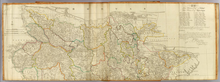
A map of the north part of Hindostan or a geographical survey of the provinces of Bengal, Bahar, Awd, Ellahabad, Agra and Delhi. By Major James Rennell, F.R.S., Engineer, Surveyor General to the Honourable the East India Company. Published 12th May, 1794 by Laurie & Whittle, 53, Fleet Street, London.
List No
2310.062
Note
Hand colored engraved map. Relief shown pictorially. Prime meridian: Calcutta. Printed on 2 sheets; joined.
Author
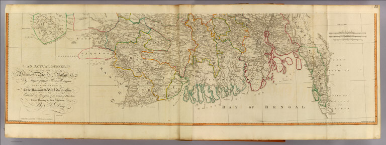
Robert Laurie & James Whittle
Full Title
(An actual survey, of the provinces of Bengal, Bahar &c. North half. By Major James Rennell, Engineer, Surveyor General to the Honourable the East India Company, published by permission of the court of directors, from a drawing in their possession; by A. Dury. Wm. Haydon sculpt. Published 12th May, 1794, by Laurie & Whittle, 53 Fleet Street, London)
List No
2310.063
Note
Hand colored engraved map. Relief shown pictorially. Includes 1776 statement by Andrew Dury to the directors of the United Company of Merchants of England Trading to the East Indies. Prime meridian: Calcutta. Printed on 2 sheets; joined.
Author
[Dury, Andrew, Rennell, James, 1742-1830, Robert Laurie & James Whittle]
Full Title
An actual survey, of the provinces of Bengal, Bahar &c. (South half). By Major James Rennell, Engineer, Surveyor General to the Honourable the East India Company, published by permission of the court of directors, from a drawing in their possession; by A. Dury. Wm. Haydon sculpt. Published 12th May, 1794, by Laurie & Whittle, 53 Fleet Street, London.
List No
2310.064
Note
Hand colored engraved map. Relief shown pictorially. Printed on 2 sheets; joined.
Author
Society for the Diffusion of Useful Knowledge (Great Britain)
Full Title
India.
List No
2326.050
Author
Colton, G.W.
Full Title
Colton's Hindoostan or British India.
List No
2441.216
Author
[Sonnenschein, W. Swan, Allen, Bevan, G.P.]
Full Title
Physical Map of the Indian Empire. W. Swan Sonnenschein & Allen's Plastic School Atlas. (inset) The British Isles on the same scale.
List No
2490.070
Note
Raised relief.
Author
[Sonnenschein, W. Swan, Allen, Bevan, G.P.]
Full Title
Physical Map of the Indian Empire. W. Swan Sonnenschein & Allen's Plastic School Atlas. (inset) The British Isles on the same scale.
List No
2490.071
Note
Image rescanned with directional lighting to highlight raised relief.
Author
[Sonnenschein, W. Swan, Allen, Bevan, G.P.]
Full Title
Political Map of the Indian Empire. W. Swan Sonnenschein & Allen's Plastic School Atlas. (inset) The British Isles on the same scale.
List No
2490.073
Note
No raised relief.
Author
[Stieler, Adolf, Stulpnagel, F.v.]
Full Title
No. XLIX. Stieler's Hand-Atlas (No. 44b). Vorder-Indien oder das Indo-Britische Reich.
List No
2507.105
Author
Anville, Jean Baptiste Bourguignon d, 1697-1782
Full Title
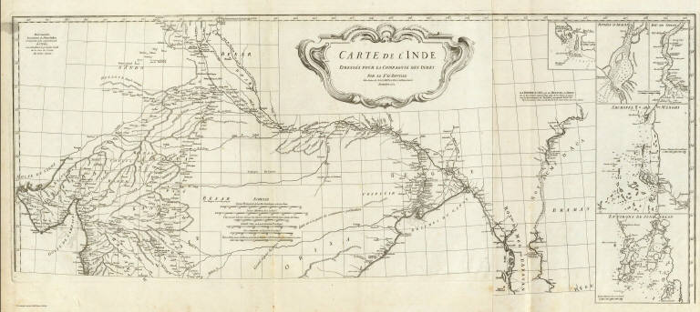
Carte de l'Inde. (Northern section). Dressee pour la Compagnie des Indies par le Sr. d'Anville, Secretaire de S.A.S.Mgr. le Duc d'Orleans. (Paris), Novembre 1752. (Grave par Guill? De-la-Haye).
List No
2603.020
Note
Engraved map on 2 sheets. Relief shown pictorially. Inset maps: Negrais -- Riviere d'Aracan -- Riv. de Sirian -- Archipel de Merghi -- Environs de Junk Selon. Includes ornamental cartouche by "H. Gravelot invenit, De Lafosse sculpsit," and geographical notes. David Rumsey Collection copy mounted as 1 sheet. Hand numbered "16" on verso.
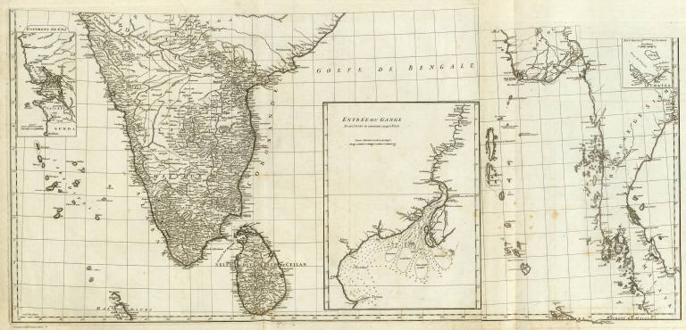
Author
Anville, Jean Baptiste Bourguignon d, 1697-1782
Full Title
(Carte de l'Inde. Southern section. Dressee pour la Compagnie des Indies par le Sr. d'Anville, Secretaire de S.A.S.Mgr. le Duc d'Orleans. Paris, Novembre 1752. Grave par) Guill? De-la-Haye.
List No
2603.021
Note
Engraved map on 2 sheets. Relief shown pictorially. Inset maps: Environs de Goa -- Entree du Gange -- Environs d'Ashem. Ganges delta map has soundings. David Rumsey Collection copy mounted as 1 sheet. Hand numbered "17" on verso.
Author
Kirkwood, Robert
Full Title
Hindoostan.
List No
2677.037
Author
Finley, Anthony
Full Title
Hindoostan. Young & Delleker Sc. Published by A. Finley Philada.
List No
2680.057
Author
Carey, Mathew
Full Title
An Accurate Map of Hindostan or India, from the best Authorities.
List No
2721.058
Note
Outline color by region. Relief shown by sketches. Prime meridian London.
Author
[Stieler, Adolf, Petermann, A.]
Full Title
Stieler's Hand-Atlas No. 63. Indien & Inner-Asien in 2 Blattern. (Bombay. Calcutta. Madras. Point de Galle.)
List No
2761.070
Author
Rand McNally and Company
Full Title
India. (insets) Southern Provinces of India. Malay Peninsula.
List No
2790.343
Author
Cram, George Franklin
Full Title
India. (inset) South Eastern Provinces of India.
List No
2809.155
Note
Border of map has list of cities and populations, keyed to map. Relief shown by hachures. Prime meridians Washington D.C. and Greenwich. Prefectures differentiated in full color.
Author
[Oddy, S.A., Wallis, James]
Full Title
Hindoostan. London, Published by S.A. Oddy, No. 20 Warwick Lane. Engraved by Jas. Wallis.
List No
2972.026
Author
Cummins Map Co.
Full Title
India. (inset) Bombay and Vicinity. Calcutta and Vicinity.
List No
3273.120
Note
Date estimated.
Author
Bowen, Emanuel
Full Title
A new and accurate map of the Empire of the Great Mogul, together with India on both sides the Ganges, and the adjacent countries. Drawn from the most approved modern maps and charts: the whole being regulated by astronl. observations, by Eman: Bowen. (London: Printed for William Innys, Richard Ware, Aaron Ward, J. and P. Knapton, John Clarke, T. Longman and T. Shewell, Thomas Osborne, Henry Whitridge ... M.DCC.XLVII)
List No
3733.042
Note
Engraved map. Shows forested areas, shoals, etc. Relief shown pictorially. Includes geographical notes and ornamental cartouche.
Author
Colton, G.W.
Full Title
Colton's Hindoostan or British India.
List No
3800.200
Author
[Black, Adam, Black, Charles, Hall, Sydney]
Full Title
Hindustan with Part of Caubul.
List No
3937.041
Author
Hall, S. (Sidney)
Full Title
Hindoostan. By Sidney Hall. London, published by Longman, Rees, Orme, Brown & Green, Paternoster Row, Novr. 1st. 1827.
List No
4224.028
Note
Engraved map. Boundaries hand col. Relief shown by hachures. Also numbered XXVII.
Author
Schonberg & Co.
Full Title
Hindoostan.
List No
4324.040
Note
Relief shown in hachures. Prime meridians are Greenwich and Washington D.C. Counties differentiated by full color.
Author
Cram, George Franklin
Full Title
Indian Empire.
List No
4558.078
Author
Colton, G.W.
Full Title
Colton's Hindostan or British India. Published By G. W & C. B. Colton & Co., No. 172 William St. New York.
List No
4587.104
Note
Prime meridians are Greenwich and Washington D.C. (inset) Continuation of British India.
Author
[Brue, Adrien Hubert, 1786-1832, Levasseur, E.]
Full Title
Carte Generale des Indes en Deca et au dela du Gange. Dresse par A. Brue, Geographe. Reoue par E. Levasseur, Membre de l'Institut, Institut Geographique de Paris. Ch. Delagrave. Editeur de la Societe de Geographie. 58 Rue des Ecoles. Atlas Universel en 67 feuilles No. 46. (inset) Punjab.
List No
4607.045
Note
Relief shown by hachures. Railroads. Prime meridian Paris. Six scales. Shows colonies and possessions of European and native powers.
Author
Burr, David H., 1803-1875
Full Title
Hindostan. Entered ... 1835 by Thomas Illman ... New York.
List No
4628.024
Note
In full color.
Author
[Covens et Mortier, L'Isle, Guillaume de, 1675-1726]
Full Title
Carte des Cotes de Malabar et de Coromandel, presentee au Roy. Par Guillaume de l'Isle. A Amsterdam, Chez J. Covens et C. Mortier, Geographes. (Title in upper margin:) Orarum Malabariae, Coromandelae, &c. tabula accuratissima. (1742)
List No
4638.084
Note
Engraved map in outline color. Relief shown pictorially.
Author
[Tardieu, Ambroise, Vuillemin, A., Duvotenay, Erhard, Testarode, E.]
Full Title
Prequ'ile de L'Inde.
List No
4697.026
Author
Dussieux, L.
Full Title
145. Cartes de l'Inde pour servir a l'Histoire de la rivalite de la France et de l'Angleterre dans l'Inde10. Epoque de la Puissance Francaise Sous Dupleix et de Bussy avant les traites de Madres et de Paris. 146. Cartes de l'Inde pour servir a l'Histoire de la rivalite de la France et de l'Angleterre dans l'Inde 20. Commencements de la Puissance Anglaise. Sous Clive et Warren Hastings jusqu'au traite de Versailles 1783.
List No
4759.134
Note
Date estimated.
Author
L'Isle, Guillaume de, 1675-1726
Full Title
Carte des Cotes de Malabar et de Coromandel, presentee au Roy. Par son tres humble, tres obeissant et tres fidele sujet, G. Delisle. Marin sculpsit. A Paris, chez l'Auteur G. Delisle Premier Geographe de Sa Majeste de l'Academie Rle. des Sciences, sur le Quay de l'Horloge, av. Pr. 1723.
List No
4764.085
Note
Engraved map in outline color. Relief shown pictorially.
Author
Flemming, Carl
Full Title
Vorderindien. Lithographie, Druck u. Verlag von C. Flemming in Glogau. (1855)
List No
4765.074
Note
Hand colored lithographed map. Relief shown by hachures. Includes inset. Prime meridians: Ferro, Greenwich and Paris.
Author
Johnson, Alvin Jewett, 1827-1884.
Full Title
Johnson's Hindoostan and Farther India. Published by Alvin J. Johnson & Son, New York. Entered ... 1867, by A.J. Johnson ... New York. (to accompany) Johnson's New Illustrated Family Atlas Of The World ... MDCCCLXXX (1880). (inset) Ganges. (with) Singapore.
List No
4830.115
Note
Engraved hand colored in outline map. Shows cities, towns, villages, roads, canals, mountains and rivers. Relief shown by hachures. Depth shown by isolines. Prime meridians are Greenwich and Washington. Includes notes.
Author
Mitchell, Samuel Augustus
Full Title
Hindoostan. (inset) Delta of the Ganges.
List No
4835.083
Author
[Stieler, Adolf, Stulpnagel, F.v.]
Full Title
No. XLIX. Stieler's Hand-Atlas (No. 44b). Vorder-Indien oder das Indo-Britische Reich.
List No
4973.104
Author
[Edward Stanford Ltd., Stanford, Edward]
Full Title
India and the adjacent parts of Beluchistan, Afghanistan, Turkestan, the Chinese Empire, and Siam. India South. London atlas series. Stanford's Geogl. Estabt. London : Edward Stanford, 26 & 27, Cockspur St., Charing Cross, S.W. (1901)
List No
5075.067
Note
Full color. Relief shown by hachures and spot heights. Shows settlements, roads, railroads, etc.
Author
[Edward Stanford Ltd., Stanford, Edward]
Full Title
Burma and adjacent countries. London atlas series. Stanford's Geogl. Estabt. London : Edward Stanford, 26 & 27, Cockspur St., Charing Cross, S.W. (1901)
List No
5075.069
Note
Full color. Relief shown by hachures and spot heights. Shows settlements, roads, railroads, etc.
Author
[Sohr, Karl, Flemming, Carl]
Full Title
Vorderindien.
List No
5200.063
Author
Letts, Son & Co.
Full Title
General map of India. Letts's popular atlas. Letts, Son & Co. Limited, London. (1883)
List No
5371.081
Note
Colored map. Relief shown by hachures and spot heights. Shows political divisions, cities, railroads, rivers, etc. Inset maps: Continuation of the map on east side of Bay of Bengal, the British provinces beyond the Ganges comprising Arracan, Pegu, Tenasserim, Penang, &c. -- England on the same scale as India.
|