|
Author
[Ford Motor Company, United States. Army. Air Corps, Geological Survey (U.S.). Topographic Branch]
Full Title
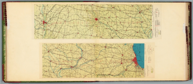
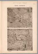
Air navigation map no. 9 (experimental) : Chicago, Ill. to Iowa City, Iowa. Compiled and reproduced by the Engineer Reproduction Plant, Corps of Engineers. Under the direction of the Airways Section, Office Chief of Air Corps. 1924. Engineer Reproduction Plant, U.S. Army, Washington Barracks, D.C. 4915. 1924. -- Air navigation map [10] (experimental) : Iowa City, Iowa to Omaha, Nebr. Prepared under the direction of the Airways Section Office of the Chief of Air Service by the Topographic Branch, U.S. Geological Survey, 1924. Engineer Reproduction Plant, U.S. Army, Washington Barracks, D.C. 4915-10. 1924.
List No
14501.007
Note
Two aeronautical charts representing the areas from Chicago, Illinois, to Iowa City, Iowa, and from Iowa City, Iowa, to Omaha, Nebraska. Features military, municipal, commercial, emergency, and seaplane landing fields. Also shows political boundaries, roads, railways, cities, towns, topography, bodies of water, and drainage. Relief shown with contour lines and color coding. Maps include latitudinal and longitudinal lines, legend, scale statements, and bar scales given in miles, as well as compass roses oriented toward top of sheet (with slight variation between the two maps). Color lithographs. Together, maps are 57 x 96 cm on double sheet, 60 x 136 cm. Map number 10 provided with a handwritten annotation.
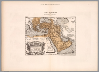
Author
Khanzadyan, Zadig
Full Title
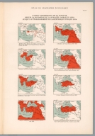
Cartes historiques des geographes musulmans. (to accompany) Atlas de geographie economique de Turquie : par Z. Khanzadian. Editeur L. de Bertalot. 1924.
List No
13321.020
Note
Six historical color maps by Muslim Geographers, on sheet 55x37. Including Carte No. 1: Carte generale d' Al-Istakhri et Ibn Ḥawqal. Xeme. Siecle. No.2: Carte generale de l' Idrisi l' an 1154. Cartes No.3-6 : Possessions tourques dans la mer Ionienne. Les provinces Tourques du Caucase. Arabie. Perse. 1640 par Kiatib-Tchekebi. Covering the world, Africa, Turkey, Saudi Arabi and Iran. In Franche and Ottoman Turkish languages. Relief shown by hachures and pictorially.
Author
Khanzadyan, Zadig
Full Title
Cartes historiques de la Turquie : Depuis la fondation de la dynastie Osman en 1300 : jusqua l' etablishment de la Republique Turque 1924. (to accompany) Atlas de geographie economique de Turquie : par Z. Khanzadian. Editeur L. de Bertalot. 1924.
List No
13321.023
Note
8 historical and chronological maps of Turkey on 1 sheet, on sheet 55x37. Show the founding of the Osman Dynasty in 1300 to the establishment of the Turkish Republic 1924. Maps dated 1285-1923.
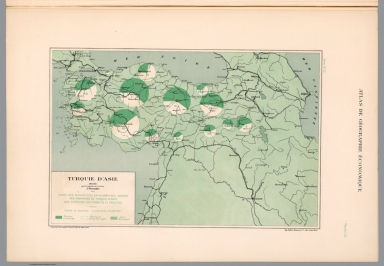
Author
Khanzadyan, Zadig
Full Title
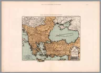
Turquie d'Asie et Caucase : Relief du sol. (to accompany) Atlas de geographie economique de Turquie : par Z. Khanzadian. Editeur L. de Bertalot. 1924.
List No
13321.026
Note
2 geological map of Asia Minor, the Caucasus & the Black Sea on 1 sheet 55x37. Including shaded relief map and tectonic plate map. Tectonic movement shown by black lines. Volcanoes shown by black squares.
Author
Khanzadyan, Zadig
Full Title
Profils des routes de la Chaine Pontique. Dressee par Z. Khanzadian. (to accompany) Atlas de geographie economique de Turquie : par Z. Khanzadian. Editeur L. de Bertalot. 1924.
List No
13321.037
Note
Color map and profile of Pontic Mountains. Map shows roads, rivers, and major cities. Relief shown by contours and spot heights.
Author
Khanzadyan, Zadig
Full Title
Turque d' Asie. Dressee par Z. Khanzadian. Recettes et depenses generales de Turquie par Vilayet. Graved P. Monsanglant, Paris. Imp. Monrocq, Paris. (to accompany) Atlas de geographie economique de Turquie : par Z. Khanzadian. Editeur L. de Bertalot. 1924.
List No
13321.045
Note
Color map of the general revenues and expenses of Turkey. Includes color coded legend.
Author
Khanzadyan, Zadig
Full Title
Cartes historiques des geographes musulmans : Les possessions de l'Empire Ottoman en Europe = Uruppa. Imp. Gaillac - Monrocq et Cie. Paris. Atlas de Kiatib - Tchelebi, 1700. (to accompany) Atlas de geographie economique de Turquie : par Z. Khanzadian. Editeur L. de Bertalot. 1924.
List No
13321.021
Note
Color map of the possessions of the Ottoman Empire in Europe. Includes decorative title cartouche. In Franche and Ottoman Turkish languages. Relief shown by hachures and pictorially.
Author
Khanzadyan, Zadig
Full Title
Cartes historiques : Dulcert 1330. Villadeste 1350. Atlas Atlas de geographie economique, par Z. Khanzadian. (to accompany) Atlas Atlas de geographie economique.de Turquie : Editeur L. de Bertalot. 1924.
List No
13321.022
Note
2 black and white nautical charts of Ottoman Empire, on one sheet 55x37.
Author
Khanzadyan, Zadig
Full Title
Cartes historiques des geographes Occidentaux. Turcici Imperii Descriptio. Ortelius, 1580. (to accompany) Atlas de geographie economique de Turquie : par Z. Khanzadian. Editeur L. de Bertalot. 1924.
List No
13321.024
Note
Historical map of Western geographers. Ortelius map of the Turkish Empire, covering the Middle East, Turkey and the Eastern Mediterranean from Sicily to Cyprus. Includes ornate title cartouche, sailing vessels, a sea monster in the Black Sea and descriptive notes on the map.
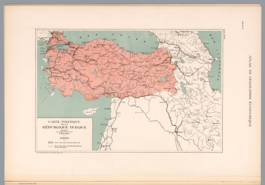
Author
Khanzadyan, Zadig
Full Title
Carte politique de la Turque. Dressee Z. Khanzadyan. Grave chez P. Monsanglant, Paris. (to accompany) Atlas de geographie economique de Turquie : par Z. Khanzadian. Editeur L. de Bertalot. 1924.
List No
13321.025
Note
Political map of Turkey. Shows boundaries, roads, railroads, major cities, rivers and lakes. Includes legend.
Author
Khanzadyan, Zadig
Full Title
Turquie d'Asie. Dressee par Z. Khanzadian. Grave chez P. Monsanglant, Paris. (to accompany) Atlas de geographie economique de Turquie : par Z. Khanzadian. Editeur L. de Bertalot. 1924.
List No
13321.027
Note
Color map of Asia Minor. Shows Longitudinal Lines, isotherm lines depict the air temperature in winter and summer. Includes legend.
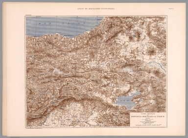
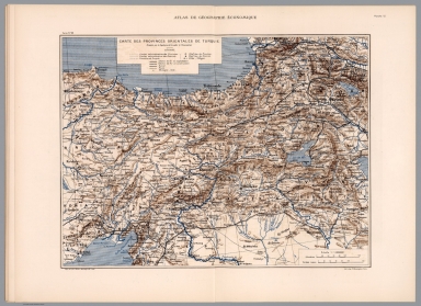
Author
Khanzadyan, Zadig
Full Title
Carte physique des provinces orientales de Turquie. Dressee par Z. Khanzadian. Grave chez P. Monsanglant, Paris. (to accompany) Atlas de geographie economique de Turquie : par Z. Khanzadian. Editeur L. de Bertalot. 1924.
List No
13321.028
Note
Physical map of eastern provinces of Turkey. Relief shown by contours, shadings and spot heights. Shows major cities, towns, rivers and lakes.
Author
Khanzadyan, Zadig
Full Title
Kars. Dressee par Z. Khanzadian. Grave chez P. Monsanglant, Paris. (to accompany) Atlas de geographie economique de Turquie : par Z. Khanzadian. Editeur L. de Bertalot. 1924.
List No
13321.029
Note
Color map of the area around the city of Kars in northeastern Turkey. Relief shown by shadings. Shows major towns, roads, trails and rivers.
Author
Khanzadyan, Zadig
Full Title
Erzeroum. Dressee par Z. Khanzadian. Imp. Gaillac - Monrocq et Cie, Paris. (to accompany) Atlas de geographie economique de Turquie : par Z. Khanzadian. Editeur L. de Bertalot. 1924.
List No
13321.030
Note
Color map of the area around the city of Erzurum. Relief shown by shadings. Shows major towns, roads, trails and rivers.
Author
Khanzadyan, Zadig
Full Title
Carte des provinces Orientales de Turquie. Dressee par Z. Khanzadian. Imp. Gaillac - Monrocq et Cie, Paris. Lith, chez P. Monsanglant, Paris. (to accompany) Atlas de geographie economique de Turquie : par Z. Khanzadian. Editeur L. de Bertalot. 1924.
List No
13321.031
Note
Color map of eastern provinces of Turkey. Relief shown by shadings. Shows administrative boundaries, capitals, major cities, towns, roads, railroads, rivers, tunnels, and lakes. Includes legend.
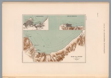
Author
Khanzadyan, Zadig
Full Title
Baie de Rizeh. Dressee par Z. Khanzadian. Imp. Gaillac - Monrocq et Cie, Paris. (to accompany) Atlas de geographie economique de Turquie : par Z. Khanzadian. Editeur L. de Bertalot. 1924.
List No
13321.032
Note
Color map of Rize Bay, with insets: Baie de Batoum and Baie de Trebizonde, cities on Black Sea coast of northeastern Turkey. Relief shown by contours and shadings. Depths shown by soundings and isolines.
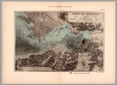
Author
Khanzadyan, Zadig
Full Title
Port de Smyrne, 1909-1913. Dressee par Z. Khanzadian. d'apres les travaux des commandants Richard Coppeland (1834) Spratt (1859) de l'Amiraute Anglaise, de Ch. Ploix (1866) Ingr. Hydrographe de la Marine Francaise. Helio Paul et Vigier, Paris. (to accompany) Atlas de geographie economique de Turquie : par Z. Khanzadian. Editeur L. de Bertalot. 1924.
List No
13321.033
Note
Color map of Port of Izmir, according to the work of the commanders richard coppeland 1834 Spratt 1859 of the British Admiralty, of Ch. Ploix (1866) Ingr. Hydrographer of the French Navy. Relief shown by shadings and spot heights. Depths shown by soundings and isolines. Map shows roads, railroads and the burned area in September 1922.
Author
Khanzadyan, Zadig
Full Title
Rade de Mersina. Dressee par Z. Khanzadian. (to accompany) Atlas de geographie economique de Turquie : par Z. Khanzadian. Editeur L. de Bertalot. 1924.
List No
13321.034
Note
Color map of city and port of Mersin on the Mediterranean coast of southern Turkey, with inset: Adana. Relief shown by contours and spot heights. Depths shown by soundings and isolines. Map shows settlements and roads.
Author
Khanzadyan, Zadig
Full Title
Carte de trace des routes de Trebizonde et des environs. Dressee par Z. Khanzadian. (to accompany) Atlas de geographie economique de Turquie : par Z. Khanzadian. Editeur L. de Bertalot. 1924.
List No
13321.035
Note
Color road map of city of Trabzon and surroundings on the Black Sea coast of northeast Turkey. Map shows settlements, roads, forests and rivers. Relief shown by contours.
Author
Khanzadyan, Zadig
Full Title
Carte de trace des routes d' Erzindjan : depuis sa jonction a celle de Trebizonde-Erzeroum. Dressee par Z. Khanzadian. Grave chez P. Monsanglant, Paris. Imp. Gaillac - Monrocq et Cie, Paris. (to accompany) Atlas de geographie economique de Turquie : par Z. Khanzadian. Editeur L. de Bertalot. 1924.
List No
13321.036
Note
Color road map of city of Erzindjan (Erzincan), from its junction to that of Trabzon-Erzurum. Map shows roads, forests and rivers. Relief shown by contours.
Author
Khanzadyan, Zadig
Full Title
Turquie d' Asie. Dressee par Z. Khanzadian. Le projet Chester. Grave chez P. Monsanglant, Paris. Imp. Gaillac - Monrocq et Cie, Paris. (to accompany) Atlas de geographie economique de Turquie : par Z. Khanzadian. Editeur L. de Bertalot. 1924.
List No
13321.038
Note
Color map and Turkey in Asia. Red lines show the Railroad for Turkey: the Chester Project, 1908–1913. Map shows roads, railroads, rivers, and major cities.
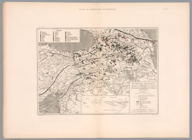
Author
Khanzadyan, Zadig
Full Title
Richesses minerales dans les provinces Orientales de Turquie, Republiques Socialistes Sovietiques du Caucase. Dressee par Z. Khanzadian. P. Monsanglant, Lith. Chichmanian et Bahry. Del. Imp. Monrocq, Paris. (to accompany) Atlas de geographie economique de Turquie : par Z. Khanzadian. Editeur L. de Bertalot. 1924.
List No
13321.039
Note
Color map of mines and mineral resources in the eastern provinces of Turkey and Republic of Caucasus, with inset: Province de Kastamouni. Map shows political and administrative boundaries, major cities, towns, roads, railroads, rivers and tunnels. Includes explanations and legend. Prime meridian is Greenwich.
Author
Khanzadyan, Zadig
Full Title
Turque d' Asie. Dressee par Z. Khanzadian. Exploitations minieres. Graved P. Monsanglant, Paris. Imp. Monrocq, Paris. (to accompany) Atlas de geographie economique de Turquie : par Z. Khanzadian. Editeur L. de Bertalot. 1924.
List No
13321.040
Note
Color map of mining operations in Asia Minor. Shows salt, coal and chromium production and location of mines.
Author
Khanzadyan, Zadig
Full Title
Turque d' Asie. Dressee par Z. Khanzadian. Carte des superficies en kilometres carres des provinces de Turquie d' Asie, des terrains cultivables et incultes. Graved P. Monsanglant, Paris. Imp. Monrocq, Paris. (to accompany) Atlas de geographie economique de Turquie : par Z. Khanzadian. Editeur L. de Bertalot. 1924.
List No
13321.041
Note
Color map of the cultivated areas in provinces of Turkey in Asia. Includes color coded legend.
Author
Khanzadyan, Zadig
Full Title
Turque d' Asie. Dressee par Z. Khanzadian. Production de cereales, legumes secs et fruits en Turquie d' Asie. Graved P. Monsanglant, Paris. Imp. Monrocq, Paris. (to accompany) Atlas de geographie economique de Turquie : par Z. Khanzadian. Editeur L. de Bertalot. 1924.
List No
13321.042
Note
Color map of the production of cereals, dried vegetables and fruits in Turkey. With inset: Principaux centres de la production mondiale. Includes color coded legend.
Author
Khanzadyan, Zadig
Full Title
Turque d' Asie. Dressee par Z. Khanzadian. Production du tabac, coton et soie. Graved P. Monsanglant, Paris. Imp. Monrocq, Paris. (to accompany) Atlas de geographie economique de Turquie : par Z. Khanzadian. Editeur L. de Bertalot. 1924.
List No
13321.043
Note
Color map of the production of tobacco, cotton and silk in Turkey. Includes color coded legend.
Author
Khanzadyan, Zadig
Full Title
Turque d' Asie. Dressee par Z. Khanzadian. Carte des forets. Graved P. Monsanglant, Paris. Imp. Monrocq, Paris. (to accompany) Atlas de geographie economique de Turquie : par Z. Khanzadian. Editeur L. de Bertalot. 1924.
List No
13321.044
Note
Color map of the forests in Turkey. Includes color coded legend.
Author
Rand McNally and Company
Full Title
The World on Mercator's Projection.
List No
5028.001
Note
Shows marine telegraph and cable lines, currents, steam vessel tracks, and nautical distances.
Author
Rand McNally and Company
Full Title
Commercial Atlas of America. Rand McNally, The Steamship Routes of The World.
List No
5028.002
Note
Includes several tables of distances between steamship destinations.
Author
Rand McNally and Company
Full Title
Commercial Atlas of America. Rand McNally, 14 x 21 Inch Map of North America.
List No
5028.003
Note
Inset is an extension of map. Relief shown by hachures.
Author
Rand McNally and Company
Full Title
Commercial Atlas of America. Rand McNally, Standard Map of United States.
List No
5028.004
Note
Shows standard railroad time zones and freight rate zones. Relief shown by hachures.
Author
Rand McNally and Company
Full Title
Commercial Atlas of America. Rand McNally, 14 x 21 inch Industrial Map of the United States.
List No
5028.005
Note
Shows broad and localized product zones including petroleum areas. Relief shown by hachures.
Author
Rand McNally and Company
Full Title
Commercial Atlas of America. Black and White Mileage Map of the United States (eastern half).
List No
5028.006
Note
Shows railroad lines and destinations.
Author
Rand McNally and Company
Full Title
Commercial Atlas of America. Black and White Mileage Map of the United States (western half).
List No
5028.007
Note
Shows railroad lines and destinations.
Author
Rand McNally and Company
Full Title
Commercial Atlas of America. (United States) East of Chicago.
List No
5028.009
Note
Insets are extensions of map. Relief shown by hachures.
Author
Rand McNally and Company
Full Title
Commercial Atlas of America. (United States) Denver to Chicago.
List No
5028.01
Note
Relief shown by hachures.
Author
Rand McNally and Company
Full Title
Commercial Atlas of America. (United States. Population Attributes).
List No
5028.011
Note
Four thematic maps showing values by state, in black and white.
Author
Rand McNally and Company
Full Title
Commercial Atlas of America. (United States) Denver to Pacific Coast.
List No
5028.012
Note
Relief shown by hachures.
Author
Rand McNally and Company
Full Title
Commercial Atlas of America. (United States. Population Attributes).
List No
5028.013
Note
Four thematic maps showing values by state, in black and white.
Author
Rand McNally and Company
Full Title
Commercial Atlas of America. Rand McNally Standard Parcel Post Map of the United States.
List No
5028.014
Note
Includes table showing rates of parcel postage.
Author
Rand McNally and Company
Full Title
Commercial Atlas of America. Rand McNally Standard Map of Maine.
List No
5028.015
Note
Relief shown by hachures. Shows river navigability. List of railroads keyed to map. List of principal cities keyed to map.
Author
Rand McNally and Company
Full Title
Commercial Atlas of America. Rand McNally Auto Trails Map District No. 6. New England. Eastern New York.
List No
5028.016
Note
Inset extension of main map. Key to Trail Markings and numbers provided. Black and white.
Author
Rand McNally and Company
Full Title
Commercial Atlas of America. Rand McNally Black and White Mileage Map, Maine.
List No
5028.017
Author
Rand McNally and Company
Full Title
Commercial Atlas of America. Rand McNally Standard Map of New Hampshire.
List No
5028.018
Note
Relief shown by hachures. Shows river navigability. List of railroads keyed to map. List of principal cities keyed to map.
Author
Rand McNally and Company
Full Title
Commercial Atlas of America. Rand McNally Black and White Mileage Map, New Hampshire and Vermont.
List No
5028.019
Author
Rand McNally and Company
Full Title
Commercial Atlas of America. Rand McNally Standard Map of Vermont.
List No
5028.020
Note
Relief shown by hachures. Shows river navigability. List of railroads keyed to map. List of principal cities keyed to map.
Author
Rand McNally and Company
Full Title
Commercial Atlas of America. Rand McNally Standard Map of Massachusetts. (with) Environs of Boston.
List No
5028.021
Note
Relief shown by hachures. Shows river navigability. List of railroads keyed to map. List of principal cities keyed to map. Boston inset at 1:142,000.
Author
Rand McNally and Company
Full Title
Commercial Atlas of America. Rand McNally Black and White Mileage Map, Connecticut, Massachusetts, and Rhode Island.
List No
5028.022
Note
Lists of principal cities keyed to map.
Author
Rand McNally and Company
Full Title
Commercial Atlas of America. Rand McNally Standard Map of Boston and Vicinity. (with) Business Portion of Boston.
List No
5028.023
Author
Rand McNally and Company
Full Title
Commercial Atlas of America. Rand McNally Standard Map of Connecticut.
List No
5028.024
Note
Relief shown by hachures. Shows river navigability. List of railroads keyed to map. List of principal cities keyed to map.
|