|
Author
Survey of India Department
Full Title
Physical configuration. Reg. No. 873, R. & A. Dept. - June 94 - 2,016. Litho. SIO. Calcutta.
List No
14252.007
Note
Lithographed topographic map of India, illustrating elevation in feet with, color coding. Map shows mountain ranges, rivers, bays, seas and islands. Includes a legend and explanatory note, as well as latitudinal and longitudinal lines, a bar scale and scale statement: Scale 1 inch = 192 miles. With inset map: England and Scotland on the same scale. 26 x 31 cm, on sheet 34 x 43 cm.
Author
Survey of India Department
Full Title
Geology. Reg. No. 76, R. & A. Dept. - Oct. 94 - 2,016. Litho., S. I. O., Calcutta.
List No
14252.010
Note
Lithographed geologic map of India, illustrating elevation in geology, with color coding. Map shows regions within country, bays, islands, and the boundaries of adjacent countries. Includes a legend and explanatory note, as well as latitudinal and longitudinal lines, a bar scale and scale statement: Scale 1 inch = 192 miles. With inset map: England and Scotland on the same scale. 26 x 31 cm, on sheet 34 x 43 cm.
Author
Survey of India Department
Full Title
Charts shewing normal season rainfall and mean temperature : Cold weather season, January and February -- Hot weather season, March to May -- South-west monsoon season, June to October -- Season of retreating south-west monsoon, November and December. Reg. No. 131, R. & A. Dept. - June 94 - 2,016. Litho., S. I. O., Calcutta.
List No
14252.013
Note
Four lithographed climatic maps of India, illustrating seasonal rainfall and temperature, with color coding. Maps show climate bands (comparing seasonal differences), as well as boundaries of adjacent countries. Includes a legend and explanatory note. Together, maps are 26 x 31 cm, on sheet 34 x 43 cm.
Author
Survey of India Department
Full Title
Average annual distribution of the rainfall. Reg. No. 79, R. & A. Dept. - Oct. 94 - 2,016. Litho., S. I. O., Calcutta.
List No
14252.014
Note
Lithographed rainfall map of India, illustrating the average distribution of rain, with color coding. Map shows regions within country, bays, seas, islands, and the boundaries of adjacent countries. Includes a legend and explanatory note, as well as latitudinal and longitudinal lines, a bar scale and scale statement: Scale 1 inch = 192 miles. With inset map: England and Scotland on the same scale. 26 x 31 cm, on sheet 34 x 43 cm.
Author
Survey of India Department
Full Title
Charts shewing history of a small cyclonic storm in the rainy season : 25th July 1891 -- 27th July 1891 -- 29th July 1891 -- 31st July 1891. Reg. No. 131, R. & A. Dept. - June 94 - 2,016. Litho., S. I. O., Calcutta.
List No
14252.015
Note
Four lithographed climatic maps of India, illustrating a small cyclone in the rainy season (as recorded over four days in July of 1891), with color coding. Maps show rainfall in the storm (comparing each of the four days), as well as the boundaries of adjacent countries. Includes a legend and explanatory note. Together, maps are 26 x 31 cm, on sheet 34 x 43 cm.
Author
Survey of India Department
Full Title
Canal systems of India. Reg. No. 350, R. & A. Dept. - Nov. 94 - 2,016. Litho., S. I. O., Calcutta.
List No
14252.018
Note
Lithographed canal map of India, illustrating the canal systems, with blue lines. Map shows major cities, rivers, bays, seas and islands, as well as the boundaries of adjacent countries. Indexed to indicate the names of canals, such as Buckingham Canal and Krishna Canal, with index in margins. Includes latitudinal and longitudinal lines, a bar scale and scale statement: Scale 1 inch = 192 miles. With inset map: England and Scotland on the same scale. 26 x 31 cm, on sheet 34 x 43 cm.
Author
Survey of India Department
Full Title
Crops. Sheet 1 : Cotton -- Wheat -- Rice -- Barley. Reg. No. 319, R. & A. Dept. - June 95 - 2,016. Litho., S. I. O., Calcutta.
List No
14252.025
Note
Four lithographed agricultural maps of India, illustrating crops in India, with color coding. Maps show the location of cotton, wheat, rich and barley, and the financial return of each, as well as the boundaries of adjacent countries. Each map includes a legend and explanatory note. First in a series of three maps showing various crops. Together, maps are 26 x 31 cm, on sheet 34 x 43 cm.
Author
Survey of India Department
Full Title
Crops. Sheet 2 : Linseed -- Jowar -- Gingelly -- Bajra. Reg. No. 319, R. & A. Dept. - June 95 - 2,016. Litho., S. I. O., Calcutta.
List No
14252.026
Note
Four lithographed agricultural maps of India, illustrating crops in India, with color coding. Maps show the location of linseed, jowar, gingelly and bajra, and the financial return of each, as well as the boundaries of adjacent countries. Each map includes a legend and explanatory note. Second in a series of three maps showing various crops. Together, maps are 26 x 31 cm, on sheet 34 x 43 cm.
Author
Survey of India Department
Full Title
Crops. Sheet 3 : Tea -- Jute -- Coffee -- Indigo. Reg. No. 319, R. & A. Dept. - June 95 - 2,016. Litho., S. I. O., Calcutta.
List No
14252.027
Note
Four lithographed agricultural maps of India, illustrating crops in India, with color coding. Maps show the location of tea, jute, coffee and indigo, and the financial return of each, as well as the boundaries of adjacent countries. Each map includes a legend and explanatory note. Third in a series of three maps showing various crops. Together, maps are 26 x 31 cm, on sheet 34 x 43 cm.
Author
Survey of India Department
Full Title
Classes of forests. Reg. No. 111, R. & A. Dept. - Aug. 94 - 2,016. Zinco., S. I. O., Calcutta.
List No
14252.030
Note
Zincographed biogeography map of India, illustrating the classes of forests, with color coding. Map shows variety of vegetation (such as deciduous forests, dry evergreen forests and wet evergreen forests), as well as major cities, bays, seas, islands, and the boundaries of adjacent countries. Includes a legend and explanatory note, as well as latitudinal and longitudinal lines, a bar scale and scale statement: Scale 1 inch = 192 miles. With inset map: England and Scotland on the same scale. 26 x 31 cm, on sheet 34 x 43 cm.
Author
Survey of India Department
Full Title
Limits of the distribution of the principal kinds of trees. Reg. No. 111, R. & A. Dept. - Aug. 94 - 2,016. Zinco., S. I. O., Calcutta.
List No
14252.031
Note
Zincographed biogeography map of India, illustrating the distribution of certain trees, with color outlines. Map shows variety of trees (such as teak, sandal and cutch), as well as major cities, bays, seas, islands, and the boundaries of adjacent countries. Includes a legend and explanatory note, as well as latitudinal and longitudinal lines, a bar scale and scale statement: Scale 1 inch = 192 miles. With inset map: England and Scotland on the same scale. 26 x 31 cm, on sheet 34 x 43 cm.
Author
Survey of India Department
Full Title
Horses and ponies in British India and Mysore. Reg. No. 263, R. & A. Dept. - Dec. 94 - 2,016. Litho., S. I. O., Calcutta.
List No
14252.034
Note
Lithographed biogeography map of India, illustrating horses and ponies, with color coding. Map shows the population of horses and ponies (in thousands), as well as major cities, bays, seas, islands, and the boundaries of adjacent countries. Includes a legend and explanatory note, as well as latitudinal and longitudinal lines, a bar scale and scale statement: Scale 1 inch = 192 miles. With inset map: England and Scotland on the same scale. 26 x 31 cm, on sheet 34 x 43 cm.
Author
Survey of India Department
Full Title
Livestock : Bulls, bullocks, & cows -- Buffaloes -- Sheep & goats -- Uncultivated areas. Reg. No. 271, R. & A. Dept. - Nov. 94 - 2,016. Litho., S. I. O., Calcutta.
List No
14252.035
Note
Four lithographed biogeography maps of India, illustrating livestock, with color coding. Maps show the population of cattle, buffalo, sheep and goats (in thousands), as well as major cities, bays, seas, islands, and the boundaries of adjacent countries. Each map includes a legend and explanatory note. Together, maps are 26 x 31 cm, on sheet 34 x 43 cm.
Author
Survey of India Department
Full Title
Economic minerals : Coal -- Iron -- Oil -- Tin. Reg. No. 216, R. & A. Dept. - Oct. 94 - 2,016. Litho., S. I. O., Calcutta.
List No
14252.039
Note
Four lithographed mineral maps of India, illustrating mining, with red highlights. Maps show coal, iron, oil and tin resources, as well as major cities, bays, seas, islands, and the boundaries of adjacent countries. Together, maps are 26 x 31 cm, on sheet 34 x 43 cm.
Author
Survey of India Department
Full Title
Railways, telegraphs, and steamship routes. Reg. No. 191, R. & A. Dept. - Aug. 94 - 2,016. Photo., S. I. O., Calcutta.
List No
14252.042
Note
Photolithographed transportation map of India, illustrating railways, telegraphs and steamship routes. Map shows national and international transportation networks, as well as cities, bays, seas, islands, and the boundaries of adjacent countries. Indexed to indicate railway names of canals, such as Bengal Central and Mu Valley, with index in margins. Includes a legend and explanatory note. 26 x 31 cm, on sheet 34 x 43 cm.
Author
Survey of India Department
Full Title
Land revenue systems of British India and Mysore. Reg. No. 404, R. & A. Dept. - Aug. 94 - 2,016. Litho., S. I. O., Calcutta.
List No
14252.060
Note
Lithographed map of India, illustrating land revenue systems of British India and Mysore (specifying permanently and temporarily settled areas), with color coding. Map shows regions, as well as major cities, bays, seas, islands, and the boundaries of adjacent countries. Includes a legend and explanatory note, as well as latitudinal and longitudinal lines, a bar scale and scale statement: Scale 1 inch = 192 miles. With inset map: England and Scotland on the same scale. 26 x 31 cm, on sheet 34 x 43 cm.
Author
Survey of India Department
Full Title
Density of population. Reg. No. 101, R. & A. Dept. - Sept. 94 - 2,022. Litho., S. I. O., Calcutta.
List No
14252.064
Note
Lithographed statistical map of India, illustrating population, with color coding. Map shows major cities, bays, seas, islands, and the boundaries of adjacent countries. Includes a legend and explanatory note, as well as latitudinal and longitudinal lines, a bar scale and scale statement: Scale 1 inch = 192 miles. With inset map: England and Scotland on the same scale. 26 x 31 cm, on sheet 34 x 43 cm.
Author
Survey of India Department
Full Title
Languages. Reg. No. 489, R. & A. Dept. - Jan. 95 - 2,016. Litho., S. I. O., Calcutta.
List No
14252.067
Note
Lithographed cultural map of India, illustrating languages spoken (such as Aryan, Khasi and Tai), with color coding. Map shows regions, cities, bays, seas, islands, and the boundaries of adjacent countries. Includes a legend and explanatory note, as well as latitudinal and longitudinal lines, a bar scale and scale statement: Scale 1 inch = 192 miles. With inset map: England and Scotland on the same scale. 26 x 31 cm, on sheet 34 x 43 cm.
Author
Survey of India Department
Full Title
Religions. (Sheet 1.) : The prevailing religion in each tract -- Hindus -- Mahomedans -- Buddhists. Reg. No. 271, R. & A. Dept. - Nov. 94 - 2,016. Litho., S. I. O., Calcutta.
List No
14252.068
Note
Four lithographed cultural maps of India, illustrating religions (Hindu, Mahomedan and Buddhism), with color coding. Maps show major cities, seas, and the boundaries of adjacent countries. Each map includes a legend and explanatory note. First in a series of two maps showing religion. Together, maps are 26 x 31 cm, on sheet 34 x 43 cm.
Author
Survey of India Department
Full Title
Religions. (Sheet 2.) : Sikhs -- Jains -- Followers of animistic and aboriginal cults -- Native Christians. Reg. No. 263, R. & A. Dept. - Dec. 94 - 2,016. Litho., S. I. O., Calcutta.
List No
14252.069
Note
Four lithographed cultural maps of India, illustrating religions (Sikhism, Jainism, "cults" and Christianity), with color coding. Maps show major cities, seas, and the boundaries of adjacent countries. Each map includes a legend and explanatory note. Second in a series of two maps showing religion. Together, maps are 26 x 31 cm, on sheet 34 x 43 cm.
Author
Survey of India Department
Full Title
Public instruction in British India. Reg. No. 197, R. & A. Dept. - Aug. 94 - 2,066. Litho., S. I. O., Calcutta.
List No
14252.073
Note
Lithographed education map of India, illustrating public instruction in British India, with color coding. Map shows major cities, bays, seas, islands, and the boundaries of adjacent countries. Includes a legend and explanatory note, as well as latitudinal and longitudinal lines, a bar scale and scale statement: Scale 1 inch = 192 miles. First in a series of two maps showing education. With inset map: England and Scotland on the same scale. 26 x 31 cm, on sheet 34 x 43 cm.
Author
Survey of India Department
Full Title
Public and private instruction in British India. Reg. No. 197, R. & A. Dept. - Aug. 94 - 2,066. Litho., S. I. O., Calcutta.
List No
14252.074
Note
Lithographed education map of India, illustrating public and private instruction in British India, with color coding. Map shows major cities, bays, seas, islands, and the boundaries of adjacent countries. Includes a legend and explanatory note, as well as latitudinal and longitudinal lines, a bar scale and scale statement: Scale 1 inch = 192 miles. Second in a series of two maps showing education. With inset map: England and Scotland on the same scale. 26 x 31 cm, on sheet 34 x 43 cm.
Author
Survey of India Department
Full Title
(Text Page to) Chapter XVIII. Emigration (2).
List No
14252.077
Note
Chapter eighteen - "Emigration" - in Statistical atlas of India. Second of two pages. Includes a colored lithographed map showing the greater vicinity beyond India, from East Africa to Australia, and far away as Fiji (Reg. No. 192, R. & A. Dept. - Mar. 95 - 2,016. Litho., S. I. O., Calcutta). Corresponding map follows text.
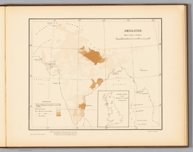
Author
Survey of India Department
Full Title
Emigration. Reg. No. 137, R. & A. Dept. - Sept. 94 - 2,066. Litho., S. I. O., Calcutta.
List No
14252.078
Note
Lithographed migration map of India, illustrating emigration from India, with color coding. Map shows major cities, bays, seas, islands, and the boundaries of adjacent countries. Includes a legend and explanatory note, as well as latitudinal and longitudinal lines, a bar scale and scale statement: Scale 1 inch = 192 miles. With inset map: England and Scotland on the same scale. 26 x 31 cm, on sheet 34 x 43 cm.
Author
Survey of India Department
Full Title
British provinces and native states. Reg. No. 141, R. & A. Dept. - Jan. 95 - 2,016. Litho., S. I. O., Calcutta.
List No
14252.082
Note
Lithographed political map of India, illustrating the British provinces and native states within India, with color coding. Map shows regions, cities, bays, seas, islands, and the boundaries of adjacent countries. Includes a legend and explanatory note, as well as latitudinal and longitudinal lines, a bar scale and scale statement: Scale 1 inch = 192 miles. With inset map: England and Scotland on the same scale. 26 x 31 cm, on fold-out sheet 34 x 86 cm.
Author
Vallardi, Francesco
Full Title
Profilo geometrico delle Alpi Marittime : Tra il Monte dello Schiavo Sopra Albenga e Quello dell'Inciastraja presso le Sorgenti della Stura. Casa Edit. Dottor F. Vallardi.
List No
14396.006
Note
Profile view showing the Maritime Alps of Italy. Features different mountain ranges with peaks labeled. Relief shown with peak heights. Includes coordinate points, three bar scales and descriptive notes. Indexed to indicate valley names. Colored engraving. Map is 50 x 69 cm, on double sheet 60 x 84 cm. Within section entitled Il profilo geometrico delle Alpi.
Author
Vallardi, Francesco
Full Title
Carta della Provincia di Cuneo. Stabo. Lito. della Casa Editrice Dr. Francesco Vallardi. C. Conalbi inc.
List No
14396.021
Note
Political map of the province of Cuneo, Italy. Features political boundaries, cities, railways, roads, topography, bodies of water and drainage. Relief shown with hachures. Includes a legend and three bar scales. Colored engraving. Map is 38 x 51 cm, on sheet 42 x 60 cm. Within section entitled Italia Settentrionale : Piemonte e Liguria.
Author
[Vallardi, Francesco, Mezzacapo, Carlo, Mezzacapo, Luigi]
Full Title
Carta del Golfo della Spezia, disegnata con la scorta de migliori materiali esistenti, sotto la direzione di Carlo e Luigi Mezzacapo, Milano, Antica Casa Editrice Dott. Francesco Vallardi. P. Albini inc. A. Anfossi dis.
List No
14396.025
Note
Hydrographic map of the Gulf of La Spezia, Italy. Features cities, railways, roads, topography, bodies of water, drainage, coastlines, islands and water depths. Relief shown with hachures. Includes a legend, two bar scales and a scale statement, as well as a compass rose with north oriented toward top of sheet. Black and white engraving. Map is 36 x 53 cm, on sheet 42 x 60 cm. Within section entitled Italia Settentrionale : Piemonte e Liguria.
Author
Vallardi, Francesco
Full Title
Provincia di Milano. Milano-Antica, Casa Editrice Dr. Francesco Vallardi, Tipografo Editore. F. Naymiller dis. P. Allodi e figlio inc.
List No
14396.031
Note
Political map of the province of Milano, Italy. Features political boundaries, cities, railways, roads, topography, bodies of water and drainage. Relief shown with hachures. Includes a legend, latitudinal and longitudinal lines, as well as a bar scale. Two inset maps: Monza -- Lodi. Inset maps indexed to indicate names of buildings. Colored engraving. Map is 37 x 50 cm, on sheet 42 x 60 cm. Within section entitled Italia Settentrionale : Lombardia.
Author
Vallardi, Francesco
Full Title
Carta delle Provincie Venete. Milano, Dottre. Francesco Vallardi, tipografo-editore.
List No
14396.035
Note
Political map of the province of Veneto, Italy. Features political boundaries, cities, railways, roads, topography, bodies of water, drainage, coastline and islands. Relief shown with hachures. Includes a legend, latitudinal and longitudinal lines, as well as two bar scales. Tables listing administrative divisions. Colored engraving. Map is 51 x 66 cm, on double sheet 60 x 84 cm. Within section entitled Italia Settentrionale : Venezia.
Author
Vallardi, Francesco
Full Title
Carta orografica ed idrografica della Laguna Veneta. Casa Editrice, Dott. Francesco Vallardi, Milano. R. Gast. inc.
List No
14396.036
Note
Hydrographic map of the Venetian Lagoon, Italy. Features cities, railways, roads, vegetation, bodies of water, drainage, coastline, islands and water depths. Includes a legend, latitudinal and longitudinal lines, a bar scale and scale statement, as well as a compass rose with north oriented toward upper right of sheet. Inset map: Venezia. Inset map indexed to indicate names of buildings. Colored engraving. Map is 56 x 77 cm, on double sheet 60 x 84 cm. Within section entitled Italia Settentrionale : Venezia.
Author
Vallardi, Francesco
Full Title
Provincia di Firenze. Milano Dr. Francesco Vallardi, Tipografo-Editore.
List No
14396.051
Note
Political map of the province of Florence, Italy. Features political boundaries, cities, railways, roads, topography, bodies of water and drainage. Relief shown with hachures. Includes a legend, latitudinal and longitudinal lines, as well as three bar scales. Six inset maps: San Miniato -- Modigliana -- Volterra -- Postoja -- Prato -- Pescia. Inset maps indexed to indicate place names. Colored engraving. Map is 54 x 34 cm, on sheet 60 x 42 cm. Within section entitled Italia centrale : Toscana.
Author
Vallardi, Francesco
Full Title
Provincie di Livorno e Pisa -- Provincie di Lucca e di Massa Carrara. Casa Edit. D. Francesco Vallardi.
List No
14396.052
Note
Two political maps of the provinces of Livorno, Pisa, Lucca and Massa Carrara, Italy. Maps feature political boundaries, cities, railways, roads, topography, bodies of water, drainage, coastlines and islands. Relief shown with hachures. Maps include legends, latitudinal and longitudinal lines, as well as three bar scales each. Colored engraving. Together maps are 33 x 52 cm, on sheet 42 x 60 cm. Within section entitled Italia centrale : Toscana.
Author
Vallardi, Francesco
Full Title
Le Marche, Provincie Pesaro ed Urbino, Ancona, Macerata e Ascoli Piceno. Casa Editrice Dotte. Fo. Vallardi, Milano. Inc. C. Azimonti.
List No
14396.056
Note
Political map of the region of Marche, with the provinces of Pesaro and Urbino, Ancona, Macerata and Ascoli Piceno, Italy. Features political boundaries, cities, railways, roads, topography, bodies of water, drainage, coastline and islands. Relief shown with hachures. Includes a legend, latitudinal and longitudinal lines, as well as two bar scales. Inset map shows the north-easternmost part of the province. Colored engraving. Map is 73 x 53 cm, on double sheet 84 x 60 cm. Within section entitled Italia centrale : Marche.
Author
Vallardi, Francesco
Full Title
Carte corografica della Provincia di Roma. Milano-Antica Casa Editrice Dott. Francesco Vallardi. Geomtra. Enrico Bonatti dir. P. Allodi e figlio inc.
List No
14396.058
Note
Political map of the province of Rome, Italy. Features political boundaries, cities, railways, roads, topography, bodies of water, drainage, coastline and islands. Relief shown with hachures. Includes a legend, latitudinal and longitudinal lines, as well as two bar scales. Colored engraving. Inset map shows the northernmost part of the province. With table: Cenni statistici. Map is 72 x 54 cm, on double sheet 84 x 60 cm. Within section entitled Italia centrale : Provincia di Roma.
Author
Vallardi, Francesco
Full Title
Provincia di Napoli -- Provincia di Salerno, Principato Citeriore. Stabo. Lito. della Casa Editrice Dr. Francesco Vallardi.
List No
14396.067
Note
Political map maps of the provinces of Naples and Salerno, Italy. Maps feature political boundaries, cities, railways, roads, topography, bodies of water, drainage, coastlines and islands. Relief shown with hachures. Maps include legends, latitudinal and longitudinal lines, as well as three bar scales each. Inset map: Pompei. Colored engraving. Together maps are 52 x 35 cm, on sheet 60 x 42 cm. Within section entitled Italia meridionale.
Author
Vallardi, Francesco
Full Title
Carta moderna dell'Isola di Sicilia e delle Isole Minori Circonvicine. Milano, Dott. Francesco Vallardi, tipografo-editore. G. Maina, e V. Stanghi inc. G. Pozzi scrisse.
List No
14396.071
Note
Political map of the island of Sicily, Italy. Features political boundaries, cities, railways, roads, topography, bodies of water, drainage, coastline and islands. Relief shown with hachures. Includes a legend, latitudinal and longitudinal lines, as well as three bar scales. Inset map: [I. di Gozzo and I. di Malta]. Colored engraving. Map is 53 x 67 cm, on double sheet 60 x 84 cm. Within section entitled Isola.
Author
[Vallardi, Francesco, Amati]
Full Title
Carta dell'Isola di Sardegna. Milano dal Dott. Franc. Vallardi. Riveduta dal Profe. Amati nel 1865.
List No
14396.072
Note
Political map of the island of Sardinia, Italy. Features political boundaries, cities, railways, roads, topography, bodies of water, drainage, coastline and islands. Relief shown with hachures. Includes a legend, latitudinal and longitudinal lines, as well as three bar scales. Colored engraving. Map is 56 x 42 cm, on double sheet 84 x 60 cm. Within section entitled Isola.
Author
[Suomen Maantieteellinen Seura, Tilgmann, Ferdinand, 1832-1911]
Full Title
No. 20. Viljatulo 1893-1895. = Sädesskörden 1893-1895. : I. -- II. -- III. -- IV. -- V. -- VI. -- VII. -- VIII.
List No
14366.032
Note
Eight agricultural maps of Finland. Maps feature grain harvests, including rye, barley and oats, from 1893 to 1895. Maps also show political boundaries, cities, railways, bodies of water, drainage, coastlines and islands. Maps include latitudinal and longitudinal lines, as well as legends. Colored lithograph. Together, maps are 37 x 53 cm, on double sheet 43 x 60 cm. Text presented in parallel Finnish and Swedish.
Author
[Pasa, Ali Seref, Esref, Hafiz Ali]
Full Title
Kore; Japonya = Korea; Japan. 1311 (1895). Tabie ve Nnashiri Hasan Ferid. (to accompany) Yeni cografya atlasi - ىگى جغرافىا آطلسى = New geographical atlas. Dersa'adet (Istanbul), 1307-1309 (1891-1893).
List No
13621.027
Note
Map of Korea and Japan, covers East of China. Includes 2 insets: Kuril Islands; Osaka and Hiroshima.
Author
[Pasa, Ali Seref, Esref, Hafiz Ali]
Full Title
Jamahiria Müttefik Amerika = United States of America. 1311 (1895). Tabie ve Nnashiri Hasan Ferid. (to accompany) Yeni cografya atlasi - ىگى جغرافىا آطلسى = New geographical atlas. Dersa'adet (Istanbul), 1307-1309 (1891-1893).
List No
13621.034
Note
Map of the United States of America. Covers part of Canada and Mexico. Shows State boundaries in red.
Author
Anestis Konstantinidis, 1846-190
Full Title
Pankósmios geografikós charths. Anésti konstantinidis Ekdotie. (to accompany) Neótatos geografikos atlas. En Athēnais 1895.
List No
13551.002
Note
Double hemisphere global geographical charths, engraved hand color. With inset maps of the world and Northern and Southern Hemispheres.
Author
Anestis Konstantinidis, 1846-190
Full Title
Eyropi. Anésti konstantinidis Ekdotie en athinais 1894. (to accompany) Neótatos geografikos atlas. En Athēnais 1895.
List No
13551.003
Note
Folded hand color map of Europe, with inset profile of comparative mountain heights in Europe.
Author
Anestis Konstantinidis, 1846-190
Full Title
Chártis toy vasileíou the Ellados. Anésti konstantinidis Ekdotie. (to accompany) Neótatos geografikos atlas. En Athēnais 1895.
List No
13551.004
Note
Folded map of Greece, with Aegean & Ionian islands, with 2 insets.
Author
Anestis Konstantinidis, 1846-190
Full Title
Chártis toy vasileíou the Ellados. Anésti konstantinidis Ekdotie (to accompany) Neótatos geografikos atlas. En Athēnais 1895.
List No
13551.005
Note
Folded map of the Balkan peninsula, with inset profile of comparative mountain heights in the region.
Author
Anestis Konstantinidis, 1846-190
Full Title
Asia. Anésti konstantinidis Ekdotie (to accompany) Neótatos geografikos atlas. En Athēnais 1895.
List No
13551.018
Note
Folded map of Asia.
Author
Anestis Konstantinidis, 1846-190
Full Title
Mikrá Asía : Archaía kai sýnchronos Asiatikí Tourkía. Anésti konstantinidis Ekdotie (to accompany) Neótatos geografikos atlas. En Athēnais 1895.
List No
13551.019
Note
Folded map of Asia Minor ancient and modern Asian Turkey.
Author
Anestis Konstantinidis, 1846-190
Full Title
Afriki. Anésti konstantinidis Ekdotie (to accompany) Neótatos geografikos atlas. En Athēnais 1895.
List No
13551.020
Note
Map of Africa.
Author
Anestis Konstantinidis, 1846-190
Full Title
Vóreios Ameriki. Anésti konstantinidis Ekdotie (to accompany) Neótatos geografikos atlas. En Athēnais 1895.
List No
13551.021
Note
Map of North America. Shows political and state boundaries. Includes Central America and part of South America.
Author
Anestis Konstantinidis, 1846-190
Full Title
Norios Ameriki. Anésti konstantinidis Ekdotie (to accompany) Neótatos geografikos atlas. En Athēnais 1895.
List No
13551.022
Note
Map of South America.
|