|
Author
Vogel, Carl
Full Title
Sect. 1: Schleswig
List No
15961.003
Note
Sheets dated from 1891 to 1893.
Author
Vogel, Carl
Full Title
Sect. 5: Konigsberg.
List No
15961.007
Note
Sheets dated from 1891 to 1893.
Author
Vogel, Carl
Full Title
Sect. 22: Strassburg I/E
List No
15961.024
Note
Sheets dated from 1891 to 1893.
Author
Vogel, Carl
Full Title
Sect. 25: Mulhausen I/E
List No
15961.027
Note
Sheets dated from 1891 to 1893.
Author
Survey of India Department
Full Title
Charts shewing history of a small cyclonic storm in the rainy season : 25th July 1891 -- 27th July 1891 -- 29th July 1891 -- 31st July 1891. Reg. No. 131, R. & A. Dept. - June 94 - 2,016. Litho., S. I. O., Calcutta.
List No
14252.015
Note
Four lithographed climatic maps of India, illustrating a small cyclone in the rainy season (as recorded over four days in July of 1891), with color coding. Maps show rainfall in the storm (comparing each of the four days), as well as the boundaries of adjacent countries. Includes a legend and explanatory note. Together, maps are 26 x 31 cm, on sheet 34 x 43 cm.
Author
[Pelet, Paul, 1849-1927, Challamel, Augustin, 1818-1894, Hausermann, R., active 1875-1915]
Full Title
Colonies Françaises. Nouvel atlas des colonies Françaises par Paul Pelet, 1889, No 1. A. Challamel, Éditeur, 5 rue Jacob, Paris. Gravé par R. Hausermann, Paris, Imp. Lemercier et Cie.
List No
14300.011
Note
World map showing French colonies around the world in 1889. Title translates to: French colonies. Features political boundaries, ocean transportation routes, telegraph and cable lines, as well as French consulates. Includes latitudinal and longitudinal lines and a legend. Colored lithograph. Map is 21 x 35 cm, on sheet 26 x 37 cm. Accompanied by descriptive text of the same title, on preceding pages in section I. In first part of atlas.
Author
[Pelet, Paul, 1849-1927, Challamel, Augustin, 1818-1894, Hausermann, R., active 1875-1915]
Full Title
France et Allgérie-Tunisie. Nouvel atlas des colonies Françaises par Paul Pelet, 1891, No 2. A. Challamel, Éditeur, 5 rue Jacob, Paris. Gravé par R. Hausermann, Paris, Imp. Lemercier et Cie.
List No
14300.014
Note
Map of France and Tunisia, including the vicinity. Shows place names, transportation routes, water transportation transportation routes between the two nations via the Mediterranean Sea, cable lines and elevation. Relief shown with shading. Includes latitudinal and longitudinal lines and a legend, as well as a bar scale and a scale statement. With inset map, comparing the distance of the journey - measured in hours - between Paris and Algiers, from 1830 to 1888: Accélération du voyage Paris-Alger, 1830-1888 [= Acceleration of the Paris-Algiers journey 1830-1888]. Colored lithograph. Map is 31 x 25 cm, on sheet 38 x 26 cm. Accompanied by descriptive text of the same title, on preceding pages in section II. In second part of atlas, Afrique.
Author
[Pelet, Paul, 1849-1927, Challamel, Augustin, 1818-1894, Hausermann, R., active 1875-1915]
Full Title
Allgérie et Tunisie. Nouvel atlas des colonies Françaises par Paul Pelet, 1891, No 3-5. A. Challamel, Éditeur, 5 rue Jacob, Paris. Gravé par R. Hausermann, Paris, Imp. Lemercier et Cie.
List No
14300.018
Note
Map of Algeria and Tunisia, including the vicinity. Shows place names, transportation routes, topography, lakes, drainage, islands and water depths. Relief shown with shading. Includes latitudinal and longitudinal lines and a legend, as well as a bar scale and a scale statement. Colored lithograph. Map is 35 x 66 cm, on sheet 50 x 72 cm, folded to 25 x 17 cm. Accompanied by descriptive text of the same title, on preceding pages in section III, IV, V. In second part of atlas, Afrique.
Author
[Pelet, Paul, 1849-1927, Challamel, Augustin, 1818-1894, Hausermann, R., active 1875-1915]
Full Title
Sénégal et Soudan. Nouvel atlas des colonies Françaises par Paul Pelet, 1889, No 6. A. Challamel, Éditeur, 5 rue Jacob, Paris. Gravé par R. Hausermann, Paris, Imp. Lemercier et Cie.
List No
14300.021
Note
Map of Senegal and Sudan, including the vicinity. Shows place names, transportation routes, topography, lakes, drainage, coastline and islands. Relief shown with hachures. Includes latitudinal and longitudinal lines, as well as a bar scale and a scale statement. With inset map: [Banc d'Arguin] [= Bay of Arguin]. Colored lithograph. Map is 21 x 34 cm, on sheet 26 x 37 cm. Accompanied by descriptive text of the same title, on preceding pages in section VI. In second part of atlas, Afrique.
Author
[Pelet, Paul, 1849-1927, Challamel, Augustin, 1818-1894, Hausermann, R., active 1875-1915]
Full Title
Soudan et Golfe de Guinée. Nouvel atlas des colonies Françaises par Paul Pelet, 1889, No 7. A. Challamel, Éditeur, 5 rue Jacob, Paris. Gravé par R. Hausermann, Paris, Imp. Lemercier et Cie.
List No
14300.024
Note
Map of Sudan and the Gulf of Guinea, including the vicinity. Shows place names, transportation routes, topography, drainage, coastline and water transportation routes. Relief shown with hachures. Includes latitudinal and longitudinal lines, as well as a bar scale and a scale statement. Colored lithograph. Map is 21 x 33 cm, on sheet 26 x 37 cm. Accompanied by descriptive text of the same title, on preceding pages in section VII. In second part of atlas, Afrique.
Author
[Pelet, Paul, 1849-1927, Challamel, Augustin, 1818-1894, Hausermann, R., active 1875-1915]
Full Title
Gabon-Congo. Nouvel atlas des colonies Françaises par Paul Pelet, 1889, No 8. A. Challamel, Éditeur, 5 rue Jacob, Paris. Gravé par R. Hausermann, Paris, Imp. Lemercier et Cie.
List No
14300.027
Note
Map of Gabon and the Congo, including the vicinity. Shows place names, transportation routes, topography, drainage, coastline and islands. Relief shown with hachures. Includes latitudinal and longitudinal lines, as well as a bar scale and a scale statement. Colored lithograph. Map is 21 x 32 cm, on sheet 26 x 37 cm. Accompanied by descriptive text of the same title, on preceding pages in section VIII. In second part of atlas, Afrique.
Author
[Pelet, Paul, 1849-1927, Challamel, Augustin, 1818-1894, Hausermann, R., active 1875-1915]
Full Title
Obock. Nouvel atlas des colonies Françaises par Paul Pelet, 1889, No 9. A. Challamel, Éditeur, 5 rue Jacob, Paris. Gravé par R. Hausermann, Paris, Imp. Lemercier et Cie.
List No
14300.029
Note
Map of Obock (Djibouti), including the vicinity. Shows place names, transportation routes, topography, drainage, coastline, islands and ports. Relief shown with hachures. Includes latitudinal and longitudinal lines, as well as a bar scale and a scale statement. Colored lithograph. Map is 21 x 32 cm, on sheet 26 x 37 cm. Accompanied by descriptive text of the same title, on preceding pages in section IX. In second part of atlas, Afrique.
Author
[Pelet, Paul, 1849-1927, Challamel, Augustin, 1818-1894, Hausermann, R., active 1875-1915]
Full Title
Madagascar. Nouvel atlas des colonies Françaises par Paul Pelet, 1889, No 10. A. Challamel, Éditeur, 5 rue Jacob, Paris. Gravé par R. Hausermann, Paris, Imp. Lemercier et Cie.
List No
14300.032
Note
Map of Madagascar, including the vicinity. Shows place names, transportation routes, topography, drainage, coastlines, islands and ports. Relief shown with hachures. Includes latitudinal and longitudinal lines, as well as a bar scale and a scale statement. Colored lithograph. Map is 33 x 25 cm, on sheet 37 x 26 cm. Accompanied by descriptive text of the same title, on preceding pages in section X. In third part of atlas, Océan Indien.
Author
[Pelet, Paul, 1849-1927, Challamel, Augustin, 1818-1894, Hausermann, R., active 1875-1915]
Full Title
Diego-Suarez, Nossi-Bé, Ste. Marie. Nouvel atlas des colonies Françaises par Paul Pelet, 1889, No 11. A. Challamel, Éditeur, 5 rue Jacob, Paris. Gravé par R. Hausermann, Paris, Imp. Lemercier et Cie.
List No
14300.035
Note
Map of Diego-Suarez [current-day Antsiranana], and the Nossi-Bé [Nosy-Be] and Sainte-Marie islands of Madagascar. Shows place names, transportation routes, topography, drainage, coastlines, islands and ports. Relief shown with hachures. Includes latitudinal and longitudinal lines, as well as a bar scale and a scale statement. Colored lithograph. Map appears in two parts, which, together, are 21 x 32 cm, on sheet 26 x 37 cm. Accompanied by descriptive text of the same title, on preceding pages in section XI. In third part of atlas, Océan Indien.
Author
[Pelet, Paul, 1849-1927, Challamel, Augustin, 1818-1894, Hausermann, R., active 1875-1915]
Full Title
Mayotte et les Comores. Nouvel atlas des colonies Françaises par Paul Pelet, 1889, No 12. A. Challamel, Éditeur, 5 rue Jacob, Paris. Gravé par R. Hausermann, Paris, Imp. Lemercier et Cie.
List No
14300.038
Note
Map of Mayotte and the Comoros. Shows place names, transportation routes, topography, drainage, coastlines, islands and ports. Relief shown with hachures. Includes latitudinal and longitudinal lines, as well as a bar scale and a scale statement. Colored lithograph. Map is 21 x 32 cm, on sheet 26 x 37 cm. Accompanied by descriptive text of the same title, on preceding pages in section XII. In third part of atlas, Océan Indien.
Author
[Pelet, Paul, 1849-1927, Challamel, Augustin, 1818-1894, Hausermann, R., active 1875-1915]
Full Title
La Réunion et Maurice, Kerguelen. Nouvel atlas des colonies Françaises par Paul Pelet, 1889, No 13. A. Challamel, Éditeur, 5 rue Jacob, Paris. Gravé par R. Hausermann, Paris, Imp. Lemercier et Cie.
List No
14300.041
Note
Map of Réunion, Mauritius and the Kerguelen Islands. Shows place names, transportation routes, topography, drainage, coastlines, islands and ports. Relief shown with hachures. Includes latitudinal and longitudinal lines, as well as a bar scale and a scale statement. Colored lithograph. Map appears in two parts, which, together, are 21 x 32 cm, on sheet 26 x 37 cm. Accompanied by descriptive text of the same title, on preceding pages in section XIII. In third part of atlas, Océan Indien.
Author
[Pelet, Paul, 1849-1927, Challamel, Augustin, 1818-1894, Hausermann, R., active 1875-1915]
Full Title
Inde. Nouvel atlas des colonies Françaises par Paul Pelet, 1889, No 14. A. Challamel, Éditeur, 5 rue Jacob, Paris. Gravé par R. Hausermann, Paris, Imp. Lemercier et Cie.
List No
14300.044
Note
Map of India and the vicinity. Shows place names, transportation routes, topography, lakes, drainage, coastlines, islands and ports. Relief shown with hachures. Includes latitudinal and longitudinal lines, as well as a bar scale and a scale statement. With inset map [India and greater vicinity]. Colored lithograph. Map appears in two parts, which, together, are 32 x 22 cm, on sheet 37 x 26 cm. Accompanied by descriptive text of the same title, on preceding pages in section XIV. In third part of atlas, Océan Indien.
Author
[Pelet, Paul, 1849-1927, Challamel, Augustin, 1818-1894, Hausermann, R., active 1875-1915]
Full Title
Indochine. Nouvel atlas des colonies Françaises par Paul Pelet, 1889, No 15. A. Challamel, Éditeur, 5 rue Jacob, Paris. Gravé par R. Hausermann, Paris, Imp. Lemercier et Cie.
List No
14300.048
Note
Map of Indochina and the vicinity. Shows place names, transportation routes, topography, lakes, drainage, coastlines, islands and ports. Relief shown with hachures. Includes latitudinal and longitudinal lines, as well as a bar scale and a scale statement. Colored lithograph. Map is 33 x 22 cm, on sheet 37 x 26 cm. Accompanied by descriptive text of the same title, on preceding pages in section XV. In fourth part of atlas, Indochine.
Author
[Pelet, Paul, 1849-1927, Challamel, Augustin, 1818-1894, Hausermann, R., active 1875-1915]
Full Title
Cochinchine et Cambodge. Nouvel atlas des colonies Françaises par Paul Pelet, 1889, No 16. A. Challamel, Éditeur, 5 rue Jacob, Paris. Gravé par R. Hausermann, Paris, Imp. Lemercier et Cie.
List No
14300.051
Note
Map of French Cochinchina (French Indochina) and the vicinity. Shows place names, transportation routes, topography, lakes, drainage, coastlines, canals and islands. Relief shown with hachures. Includes latitudinal and longitudinal lines, as well as a bar scale and a scale statement. Colored lithograph. Map is 32 x 23 cm, on sheet 37 x 26 cm. Accompanied by descriptive text of the same title, on preceding pages in section XVI. In fourth part of atlas, Indochine.
Author
[Pelet, Paul, 1849-1927, Challamel, Augustin, 1818-1894, Hausermann, R., active 1875-1915]
Full Title
Tonkin. Nouvel atlas des colonies Françaises par Paul Pelet, 1889, No 17. A. Challamel, Éditeur, 5 rue Jacob, Paris. Gravé par R. Hausermann, Paris, Imp. Lemercier et Cie.
List No
14300.054
Note
Map of Tonkin (Vietnam) and the vicinity. Shows place names, transportation routes, topography, lakes, drainage, coastlines and islands. Relief shown with hachures. Includes latitudinal and longitudinal lines, as well as a bar scale and a scale statement. Colored lithograph. Map is 21 x 32 cm, on sheet 26 x 37 cm. Accompanied by descriptive text of the same title, on preceding pages in section XVII. In fourth part of atlas, Indochine.
Author
[Pelet, Paul, 1849-1927, Challamel, Augustin, 1818-1894, Hausermann, R., active 1875-1915]
Full Title
Nouvelle Calédonie. Nouvel atlas des colonies Françaises par Paul Pelet, 1889, No 18. A. Challamel, Éditeur, 5 rue Jacob, Paris. Gravé par R. Hausermann, Paris, Imp. Lemercier et Cie.
List No
14300.057
Note
Map of New Caledonia and the vicinity. Shows place names, transportation routes, topography, lakes, drainage, coastlines, canals and islands. Relief shown with hachures. Includes latitudinal and longitudinal lines, as well as a bar scale and a scale statement. With two inset maps: Iles Chesterfield -- Iles Wallis. Colored lithograph. Map is 21 x 32 cm, on sheet 26 x 37 cm. Accompanied by descriptive text of the same title, on preceding pages in section XVIII. In fifth part of atlas, Océanie.
Author
[Pelet, Paul, 1849-1927, Challamel, Augustin, 1818-1894, Hausermann, R., active 1875-1915]
Full Title
Nouvelle Hébrides. Nouvel atlas des colonies Françaises par Paul Pelet, 1889, No 19. A. Challamel, Éditeur, 5 rue Jacob, Paris. Gravé par R. Hausermann, Paris, Imp. Lemercier et Cie.
List No
14300.060
Note
Map of New Hebrides and the vicinity. Shows place names, transportation routes, topography, lakes, drainage, coastlines and islands. Relief shown with hachures. Includes latitudinal and longitudinal lines, as well as a bar scale and a scale statement. With two inset maps: Nouvelle Calédonie : Récifs Nord-Ouest [= New Caledonia: North-West Reefs] -- [Matthew and Fearn Islands]. Colored lithograph. Map is 31 x 22 cm, on sheet 37 x 26 cm. Accompanied by descriptive text of the same title, on preceding pages in section XIX. In fifth part of atlas, Océanie.
Author
[Pelet, Paul, 1849-1927, Challamel, Augustin, 1818-1894, Hausermann, R., active 1875-1915]
Full Title
Polynésie-Feuille I. Nouvel atlas des colonies Françaises par Paul Pelet, 1889, No 20. A. Challamel, Éditeur, 5 rue Jacob, Paris. Gravé par R. Hausermann, Paris, Imp. Lemercier et Cie.
List No
14300.063
Note
Map of Polynesia and the vicinity. Shows place names, transportation routes, topography, lakes, drainage, coastlines and islands. Relief shown with hachures. Includes latitudinal and longitudinal lines, as well as a bar scale and a scale statement. With two inset maps: [Rapa and Marotiri Islands] -- Iles Marquises [= Marquesas Islands]. Colored lithograph. Map is 21 x 32 cm, on sheet 26 x 37 cm. First of two maps showing Polynesia; second map on subsequent plate (No 21). Accompanied by descriptive text of the same title, on preceding pages in section XX, XXI. In fifth part of atlas, Océanie.
Author
[Pelet, Paul, 1849-1927, Challamel, Augustin, 1818-1894, Hausermann, R., active 1875-1915]
Full Title
Polynésie-Feuille II. Nouvel atlas des colonies Françaises par Paul Pelet, 1889, No 21. A. Challamel, Éditeur, 5 rue Jacob, Paris. Gravé par R. Hausermann, Paris, Imp. Lemercier et Cie.
List No
14300.064
Note
Map of Polynesia and the vicinity. Shows place names, transportation routes, topography, lakes, drainage, coastlines and islands. Relief shown with hachures. Includes latitudinal and longitudinal lines, as well as a bar scale and a scale statement. With four inset maps: Rapa -- Mangaréva (Gambier) -- Iles Marquises [: Noukouhiva, Ouahouka and Ouapou] -- Iles Marquises [: Tahouata, Hivaoa and Fatouhiva]. Colored lithograph. Map is 21 x 32 cm, on sheet 26 x 37 cm. Second of two maps showing Polynesia; first map on preceding plate (No 20). Accompanied by descriptive text of the same title, on preceding pages in section XX, XXI. In fifth part of atlas, Océanie.
Author
[Pelet, Paul, 1849-1927, Challamel, Augustin, 1818-1894, Hausermann, R., active 1875-1915]
Full Title
St. Pierre et Miquelon. Nouvel atlas des colonies Françaises par Paul Pelet, 1889, No 22. A. Challamel, Éditeur, 5 rue Jacob, Paris. Gravé par R. Hausermann, Paris, Imp. Lemercier et Cie.
List No
14300.067
Note
Map of the Saint-Pierre and Miquelon Islands and the vicinity. Shows place names, transportation routes, topography, lakes, drainage, coastlines and islands. Relief shown with hachures. Includes latitudinal and longitudinal lines, as well as a bar scale and a scale statement. With inset map: [Langlade ou Petite Miquelon, Grande Miquelon and St. Pierre]. Colored lithograph. Map is 31 x 22 cm, on sheet 37 x 26 cm. Accompanied by descriptive text of the same title, on preceding pages in section XXII. In sixth part of atlas, Amérique.
Author
[Pelet, Paul, 1849-1927, Challamel, Augustin, 1818-1894, Hausermann, R., active 1875-1915]
Full Title
Guadeloupe et Martinique. Nouvel atlas des colonies Françaises par Paul Pelet, 1889, No 23. A. Challamel, Éditeur, 5 rue Jacob, Paris. Gravé par R. Hausermann, Paris, Imp. Lemercier et Cie.
List No
14300.070
Note
Map of the Guadeloupe and Martinique Islands and the vicinity. Shows place names, transportation routes, topography, lakes, drainage, coastlines and islands. Relief shown with hachures. Includes latitudinal and longitudinal lines, as well as a bar scale and a scale statement. With inset map: [Anguille, St. Martin and St. Barthélemy]. Colored lithograph. Map is 31 x 22 cm, on sheet 37 x 26 cm. Accompanied by descriptive text of the same title, on preceding pages in section XXIII. In sixth part of atlas, Amérique.
Author
[Pelet, Paul, 1849-1927, Challamel, Augustin, 1818-1894, Hausermann, R., active 1875-1915]
Full Title
Guyane. Nouvel atlas des colonies Françaises par Paul Pelet, 1889, No 24. A. Challamel, Éditeur, 5 rue Jacob, Paris. Gravé par R. Hausermann, Paris, Imp. Lemercier et Cie.
List No
14300.073
Note
Map of Guyana and the vicinity. Shows place names, transportation routes, topography, lakes, drainage, coastlines and islands. Relief shown with hachures. Includes latitudinal and longitudinal lines, as well as a bar scale and a scale statement. Colored lithograph. Map is 31 x 22 cm, on sheet 37 x 26 cm. Accompanied by descriptive text of the same title, on preceding pages in section XXIV. In sixth part of atlas, Amérique.
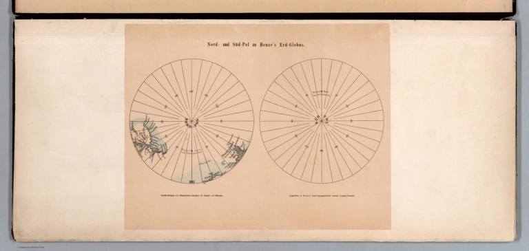
Author
Henze, Adolf
Full Title
Nord- und Süd-Pol zu Henze's Erd-Globus. Gratis-Beilage zum Illustrirten Anzeiger für Contor und Bureau. Ausgeführt in Henze's karto-typographischer Anstalt Leipzig-Neustadt.
List No
14361.002
Note
Two maps of the North and South Poles. Shows topography, coastlines and islands. Relief shown with hachures. Includes longitudinal lines. Colored lithograph. Maps are each 19 x 19 cm, on sheet 31 x 40 cm. Maps precede globe gores.
Author
Henze, Adolf
Full Title
Henze's Erd-Globus im Verhältniss wie 1/12,000,000 zur natürlichen Grösse. Druck u. Verlag von Adolf Henze in Neustadt-Leipzig. Gratis-Beilage zum "Illustrirten Anzeiger für Contor und Bureau." Ausgeführt in Henze's karto-typographischer Anstalt Leipzig-Neustadt. (1)
List No
14361.003
Note
First and second globe gores for world map. Map shows political boundaries, cities, railways, roads, ocean routes, major international telegraph lines, population, languages spoken, topography, glaciers, deserts, bodies of water, drainage, coastlines, islands and the date change line. Relief shown with hachures. Includes latitudinal and longitudinal lines. Title cartouche, legend and key appear on eighth sheet. Gores are each 146 x 28, each on a sheet 150 x 31 cm. Gores appear on twelve sheets bound together.
Author
Henze, Adolf
Full Title
Henze's Erd-Globus im Verhältniss wie 1/12,000,000 zur natürlichen Grösse. Druck u. Verlag von Adolf Henze in Neustadt-Leipzig. Gratis-Beilage zum "Illustrirten Anzeiger für Contor und Bureau." Ausgeführt in Henze's karto-typographischer Anstalt Leipzig-Neustadt. (2)
List No
14361.004
Note
Third and fourth globe gores for world map. Map shows political boundaries, cities, railways, roads, ocean routes, major international telegraph lines, population, languages spoken, topography, glaciers, deserts, bodies of water, drainage, coastlines, islands and the date change line. Relief shown with hachures. Includes latitudinal and longitudinal lines. Title cartouche, legend and key appear on eighth sheet. Gores are each 146 x 28, each on a sheet 150 x 31 cm. Gores appear on twelve sheets bound together.
Author
Henze, Adolf
Full Title
Henze's Erd-Globus im Verhältniss wie 1/12,000,000 zur natürlichen Grösse. Druck u. Verlag von Adolf Henze in Neustadt-Leipzig. Gratis-Beilage zum "Illustrirten Anzeiger für Contor und Bureau." Ausgeführt in Henze's karto-typographischer Anstalt Leipzig-Neustadt. (3)
List No
14361.005
Note
Fifth and sixth globe gores for world map. Map shows political boundaries, cities, railways, roads, ocean routes, major international telegraph lines, population, languages spoken, topography, glaciers, deserts, bodies of water, drainage, coastlines, islands and the date change line. Relief shown with hachures. Includes latitudinal and longitudinal lines. Title cartouche, legend and key appear on eighth sheet. Gores are each 146 x 28, each on a sheet 150 x 31 cm. Gores appear on twelve sheets bound together.
Author
Henze, Adolf
Full Title
Henze's Erd-Globus im Verhältniss wie 1/12,000,000 zur natürlichen Grösse. Druck u. Verlag von Adolf Henze in Neustadt-Leipzig. Gratis-Beilage zum "Illustrirten Anzeiger für Contor und Bureau." Ausgeführt in Henze's karto-typographischer Anstalt Leipzig-Neustadt. (4)
List No
14361.006
Note
Seventh and eighth globe gores for world map. Map shows political boundaries, cities, railways, roads, ocean routes, major international telegraph lines, population, languages spoken, topography, glaciers, deserts, bodies of water, drainage, coastlines, islands and the date change line. Relief shown with hachures. Includes latitudinal and longitudinal lines. Title cartouche, legend and key appear on eighth sheet. Gores are each 146 x 28, each on a sheet 150 x 31 cm. Gores appear on twelve sheets bound together.
Author
Henze, Adolf
Full Title
Henze's Erd-Globus im Verhältniss wie 1/12,000,000 zur natürlichen Grösse. Druck u. Verlag von Adolf Henze in Neustadt-Leipzig. Gratis-Beilage zum "Illustrirten Anzeiger für Contor und Bureau." Ausgeführt in Henze's karto-typographischer Anstalt Leipzig-Neustadt. (5)
List No
14361.007
Note
Ninth and tenth globe gores for world map. Map shows political boundaries, cities, railways, roads, ocean routes, major international telegraph lines, population, languages spoken, topography, glaciers, deserts, bodies of water, drainage, coastlines, islands and the date change line. Relief shown with hachures. Includes latitudinal and longitudinal lines. Title cartouche, legend and key appear on eighth sheet. Gores are each 146 x 28, each on a sheet 150 x 31 cm. Gores appear on twelve sheets bound together.
Author
Henze, Adolf
Full Title
Henze's Erd-Globus im Verhältniss wie 1/12,000,000 zur natürlichen Grösse. Druck u. Verlag von Adolf Henze in Neustadt-Leipzig. Gratis-Beilage zum "Illustrirten Anzeiger für Contor und Bureau." Ausgeführt in Henze's karto-typographischer Anstalt Leipzig-Neustadt. (6)
List No
14361.008
Note
Eleventh and twelfth globe gores for world map. Map shows political boundaries, cities, railways, roads, ocean routes, major international telegraph lines, population, languages spoken, topography, glaciers, deserts, bodies of water, drainage, coastlines, islands and the date change line. Relief shown with hachures. Includes latitudinal and longitudinal lines. Title cartouche, legend and key appear on eighth sheet. Gores are each 146 x 28, each on a sheet 150 x 31 cm. Gores appear on twelve sheets bound together.
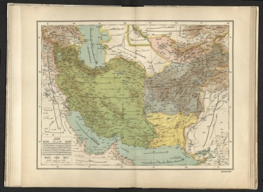
Author
[Pasa, Ali Seref, Esref, Hafiz Ali]
Full Title
Iran : Afganistan; Buhara; Belochistan. 1309 (1891). Tabie ve Nnashiri Hasan Ferid. (to accompany) Yeni cografya atlasi - ىگى جغرافىا آطلسى = New geographical atlas. Dersa'adet (Istanbul), 1307-1309 (1891-1893).
List No
13621.024
Note
Map of Iran, Afghanistan, Pakistan and Uzbekistan.
Author
[Ministere des Travaux Publics, Cheysson, Émile]
Full Title
Tonnage des Voies Navigables en 1889. Repartition du Tonnage ... I. Region du Nord et du Nord-Est. (Breakdown of the tonnage of inland waterways in 1889 by nature of goods: Area of North.)
List No
12521.019
Author
[Powell, John Wesley, 1834-1902, United States Geological Survey (USGS), Gannett, Henry, 1846-1914, King, Harry]
Full Title
(Map of the United States. Compiled under the director of Henry Gannett, Chief Topographer, by Harry King, Chief Draughtsman. Department of the Interior, United States Geological Survey, J. W. Powell, Director. 1890. Edition of April 1891. Engraved by Julius Bien & Co. New York. Sheet 7).
List No
14054.008
Note
Sheet 7 of USGS topographic map of the United States, backed with linen and bound with corresponding sheets. This sheet includes part of the southern international border, with Arizona and New Mexico, as well as northwestern Mexico and Baja California. Conveys topography with contour lines, which include elevation figures. Shows state boundaries, cities and towns, railroads, drainage, and national parks, as well as Native American territories and reservations. 40 x 64 cm, on sheet 47 x 69 cm. With inset: Alaska. (Title taken from Sheet 9.)
Author
[Powell, John Wesley, 1834-1902, United States Geological Survey (USGS), Gannett, Henry, 1846-1914, King, Harry]
Full Title
(Map of the United States. Compiled under the director of Henry Gannett, Chief Topographer, by Harry King, Chief Draughtsman. Department of the Interior, United States Geological Survey, J. W. Powell, Director. 1890. Edition of April 1891. Engraved by Julius Bien & Co. New York. Sheet 8).
List No
14054.009
Note
Sheet 8 of USGS topographic map of the United States, backed with linen and bound with corresponding sheets. This sheet includes part of the southern international border, with the south: Texas, Louisiana and Mississippi, as well as northeastern Mexico and the Gulf of Mexico. Conveys topography with contour lines, which include elevation figures. Shows state boundaries, cities and towns, railroads, drainage, and national parks, as well as Native American territories and reservations. 40 x 64 cm, on sheet 47 x 69 cm. (Title taken from Sheet 9.)
Author
[Powell, John Wesley, 1834-1902, United States Geological Survey (USGS), Gannett, Henry, 1846-1914, King, Harry]
Full Title
(Map of the) United States. Compiled under the director of Henry Gannett, Chief Topographer, by Harry King, Chief Draughtsman. Department of the Interior, United States Geological Survey, J. W. Powell, Director. 1890. Edition of April 1891. Engraved by Julius Bien & Co. New York. (Sheet 9).
List No
14054.010
Note
Sheet 9 of USGS topographic map of the United States, backed with linen and bound with corresponding sheets. This sheet includes the south: Alabama, Georgia and Florida. Bar scale and scale statement: Approximately 40 miles to 1 inch. Conveys topography with contour lines, which include elevation figures. Shows state boundaries, cities and towns, railroads, drainage, and national parks, as well as Native American territories and reservations. Descriptive text beneath title, including citations and an explanation of contour lines. Handwritten annotations, in pencil, including "Map of the" preceding the title, United States. Map originally published in 1890; this edition 1891. 40 x 64 cm, on sheet 47 x 69 cm.
Author
Rand, McNally & Co.
Full Title
Philadelphia.
List No
9733.049
Author
[Garside, G.W., Alaskan Boundary Tribunal]
Full Title
(Facsimile) Map of Pyramid Harbor & Vicinity, on Chilkat Inlet, Lynn Canal, Alaska, 1891. Surveyed by G.W. Garside, U.S. Deputy Surveyor for Alaska, Oct. 1891. Drawn by R.F. Morton, C.E., San Francisco. Alaskan Boundary Tribunal, 1903. 29. Andrew B. Graham. Photo-Litho. Washington.D.C.
List No
0009.075
Author
Appleton, D. & Co.
Full Title
United States. Copyright 1891 by Matthews-Northrup Co. Complete engineering and printing works, Buffalo and New York. (inset) Alaska. (to accompany) The Library Atlas Of Modern Geography ... New York, D. Appleton And Company 1892. (on upper margin) United States 11.
List No
0026.018
Note
Color map on 2 sheets. Shows states, territories, major cities, rivers, mountains, roads, railways. Includes " Divisional maps". Relief shown by hachures. Prime meridians are Washington and Greenwich.
Author
Appleton, D. & Co.
Full Title
Dominion of Canada. Copyright 1891 by Appleton & Co. (inset) Vancouver Island. (to accompany) The Library Atlas Of Modern Geography ... New York, D. Appleton And Company 1892. (on upper margin) Canada 12.
List No
0026.019
Note
Color map on 2 sheets. Shows states, territories, major cities, rivers, mountains, roads, railways, principal steam routes and distances from place to place. Includes " Divisional maps". Relief shown by hachures and spot heights. Prime meridian is Greenwich.
Author
Appleton, D. & Co.
Full Title
British Isles. Copyright 1891 by Appleton & Co.(to accompany) The Library Atlas Of Modern Geography ... New York, D. Appleton And Company 1892. (on upper margin) British Isles 13.
List No
0026.020
Note
Color map on 2 sheets. Shows political and administrative divisions, major cities, rivers, mountains, roads, railways, principal steam routes and distances from place to place. Includes " Divisional maps". Relief shown by hachures. Prime meridian is Greenwich.
Author
Appleton, D. & Co.
Full Title
Scotland. Copyright 1891 by Appleton & Co. (untitled insets) Glasgow; Edinburgh. (to accompany) The Library Atlas Of Modern Geography ... New York, D. Appleton And Company 1892. (on upper margin) Scotland 15.
List No
0026.025
Note
Color map on 2 sheets, with 2 insets. Shows administrative divisions, major cities, rivers, mountains, roads, railways, canals, battle fields, principal steam routes and distances from place to place. Relief shown by hachures. Spot heights in feet. Prime meridian is Greenwich.
Author
Appleton, D. & Co.
Full Title
Ireland. Copyright 1891 by Appleton & Co. (untitled insets) Belfast; Dublin. (to accompany) The Library Atlas Of Modern Geography ... New York, D. Appleton And Company 1892. (on upper margin) Ireland 16.
List No
0026.028
Note
Color map on 2 sheets, with 2 insets. Shows administrative divisions, major cities, rivers, mountains, roads, railways, canals, battle fields, principal steam routes and distances from place to place. Relief shown by hachures. Spot heights in feet. Prime meridian is Greenwich.
Author
Appleton, D. & Co.
Full Title
Holland and Belgium. Copyright 1891 by Appleton & Co. (insets) Amsterdam; Environs of Brussels; Antwerp. (to accompany) The Library Atlas Of Modern Geography ... New York, D. Appleton And Company 1892. (on upper margin) Holland & Belgium 18.
List No
0026.033
Note
Color map on 2 sheets. Shows administrative divisions, major cities, roads, railways, canals, battle fields, forts and fortifications, lighthouses, principal steam routes and distances from place to place. Prime meridian is Greenwich.
Author
Appleton, D. & Co.
Full Title
Spain and Portugal. Copyright 1891 by Appleton & Co. (insets) Gibraltar; Lisbon; Madrid. (to accompany) The Library Atlas Of Modern Geography ... New York, D. Appleton And Company 1892. (on upper margin) Spain & Portugal 20.
List No
0026.041
Note
Color map on 2 sheets. Shows administrative divisions, major cities, roads, railways, canals, battle fields, forts and fortifications, submarine cables, principal steam routes and distances from place to place, etc. Relief shown by hachures. Heights in English feet. Note: "The names of the chief towns and new provinces of Portugal are underlined".
Author
Appleton, D. & Co.
Full Title
Russia. Copyright 1891 by Appleton & Co. (untitled insets) Odessa; St. Petersburg; Moscow. (to accompany) The Library Atlas Of Modern Geography ... New York, D. Appleton And Company 1892. (on upper margin) Russia 25.
List No
0026.057
Note
Color map on 2 sheets. Shows administrative divisions, major cities, roads, railways, canals, forts and fortifications, submarine cables, principal steam routes and distances from place to place, etc. Includes reference. Relief shown by hachures and spot heights in feet. Prime meridian is Greenwich.
Author
Appleton, D. & Co.
Full Title
Austria - Hungary. Copyright 1891 by Appleton & Co. (insets) Environs of Budapest; Triest; Prague; Vienna. (to accompany) The Library Atlas Of Modern Geography ... New York, D. Appleton And Company 1892. (on upper margin) Austria 25.
List No
0026.060
Note
Color map on 2 sheets. Shows administrative divisions, major cities, roads, railways, canals, forts and fortifications, principal steam routes and distances from place to place, battle fields, forts and fortification, etc. Includes reference. Relief shown by hachures and spot heights in feet. Prime meridian is Greenwich.
Author
Appleton, D. & Co.
Full Title
Turkey in Europe : Ramania, Servia, Montenegro & Greece. Copyright 1891 by Appleton & Co. (insets) Enlarged plan of Bosporus; Constantinople; Dardanelles; Athens. (to accompany) The Library Atlas Of Modern Geography ... New York, D. Appleton And Company 1892. (on upper margin) Turkey & Greece 27.
List No
0026.063
Note
Color map on 2 sheets. Shows administrative divisions, major cities, roads, railways, forts and fortifications, principal steam routes and distances from place to place, battle fields, etc. Includes reference. Relief shown by hachures and spot heights in feet. Prime meridian is Greenwich.
Author
Appleton, D. & Co.
Full Title
Italy. Copyright 1891 by Appleton & Co. (to accompany) The Library Atlas Of Modern Geography ... New York, D. Appleton And Company 1892. (with 5 insets). (on upper margin) Italy, 28.
List No
0026.068
Note
Color map on 2 sheets. Insets: Venice; Naples; Rome; Palermo; Strait of Messina. Shows administrative divisions, major cities, roads, railways, canals, forts and fortifications, principal steam routes and distances from place to place, battle fields, etc. Includes reference. Relief shown by hachures and spot heights in feet. Prime meridian is Greenwich.
Author
Appleton, D. & Co.
Full Title
Sketch map of the Mediterranean and adjacent countries. Copyright 1891 by Appleton & Co. (to accompany) The Library Atlas Of Modern Geography ... New York, D. Appleton And Company 1892. (with 6 insets). (on upper margin) Mediterranean, 29.
List No
0026.071
Note
Color map on 2 sheets. Insets: Marseilles; Gibraltar; Alexandria; Valetta Harbours; The Maltese Islands; Cyprus. Shows political boundaries, administrative divisions, major cities, roads, canals, principal steam routes and distances from place to place, etc. Relief shown by hachures. Prime meridian is Greenwich.
Author
Appleton, D. & Co.
Full Title
Turkey in Asia. Copyright 1891 by Appleton & Co. (inset) Smyrna. (to accompany) The Library Atlas Of Modern Geography ... New York, D. Appleton And Company 1892. (on upper margin) Turkey in Asia, 30.
List No
0026.072
Note
Color map on 2 sheets. Shows political boundaries, administrative divisions, capitals, railroads, roads, canals, principal steam routes and distances from place to place, forts and fortifications, etc. Relief shown by hachures and spot heights. Prime meridian is Greenwich.
Author
Appleton, D. & Co.
Full Title
Palestine. Copyright 1891 by Appleton & Co. (insets) Jerusalem; Plan of Jerusalem. (to accompany) The Library Atlas Of Modern Geography ... New York, D. Appleton And Company 1892. (on upper margin) Palestine, 31.
List No
0026.075
Note
Color map on 2 sheets. Shows political boundaries, administrative divisions, capitals, roads, caravan routes, canals, principal steam routes and distances from place to place, forts and fortifications, etc. Inset showing detail plan of major buildings in Jerusalem. Includes explanation of Arabic words. Relief shown by hachures and spot heights. Prime meridian is Greenwich.
Author
Appleton, D. & Co.
Full Title
Arabia. Copyright 1891 by Appleton & Co. (inset) Strait of Bab-El-Mandeb. (to accompany) The Library Atlas Of Modern Geography ... New York, D. Appleton And Company 1892. (on upper margin) Arabia, 32.
List No
0026.078
Note
Color map on 2 sheets. Shows administrative divisions, railways, canals, principal steam routes and distances from place to place, forts and fortifications, etc. Relief shown by hachures and spot heights. Prime meridian is Greenwich.
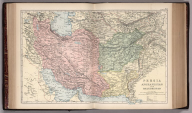
Author
Appleton, D. & Co.
Full Title
Persia, Afshanistan and Baluchistan. Copyright 1891 by Appleton & Co. (to accompany) The Library Atlas Of Modern Geography ... New York, D. Appleton And Company 1892. (on upper margin) Persia, 33.
List No
0026.079
Note
Color map on 2 sheets. Shows political and administrative divisions, railways, roads, canals, principal steam routes and distances from place to place, forts and fortifications, etc. Relief shown by hachures and spot heights. Prime meridian is Greenwich.
Author
Appleton, D. & Co.
Full Title
China. Copyright 1891 by Appleton & Co. (with 3 insets) Environs of Hong Kong, Macao & Canton; Peking; Shanghai. (to accompany) The Library Atlas Of Modern Geography ... New York, D. Appleton And Company 1892. (on upper margin) China 35.
List No
0026.085
Note
Color map on 2 sheets. Shows administrative divisions, railways, roads, principal steam routes and distances from place to place, etc. Relief shown by hachures.
Author
Appleton, D. & Co.
Full Title
East India Islands with parts of lower Burma, Siam & Anam. Copyright 1891 by Appleton & Co. (insets) Singapur; Batavia. (to accompany) The Library Atlas Of Modern Geography ... New York, D. Appleton And Company 1892. (on upper margin) East Indies 37.
List No
0026.090
Note
Color map on 2 sheets. Shows railways, principal steam routes and distances from place to place, submarine telegraph lines, etc. Includes color coded European possession in East Indies. Relief shown by hachures and spot heights. Prime meridian is Greenwich.
Author
Appleton, D. & Co.
Full Title
Egypt. Copyright 1891 by Appleton & Co. (insets) The Nile Delta and Suez Canal. Cairo. (to accompany) The Library Atlas Of Modern Geography ... New York, D. Appleton And Company 1892. (on upper margin) Egypt. 38.
List No
0026.092
Note
Color map on 2 sheets. Shows railways, principal steam routes and distances from place to place, submarine cables, fort and fortifications, etc. Relief shown by hachures and spot heights. Prime meridian is Greenwich.
Author
Appleton, D. & Co.
Full Title
Mexico. Copyright 1891 by Appleton & Co. (inset) Mexico City. (to accompany) The Library Atlas Of Modern Geography ... New York, D. Appleton And Company 1892. (on upper margin) Mexico. 41.
List No
0026.099
Note
Color map on 2 sheets. Shows major cities and towns, railways, roads, battle fields, principal steam routes and distances from place to place, submarine cables, etc. Relief shown by hachures and spot heights. Prime meridian is Greenwich.
Author
Appleton, D. & Co.
Full Title
Australia. Copyright 1891 by D. Appleton & Co. (with 4 insets). (to accompany) The Library Atlas Of Modern Geography ... New York, D. Appleton And Company 1892. (on upper margin) Australia 47.
List No
0026.120
Note
Color map on 2 sheets. Insets: Plan of Melbourne & suburbs, Adelaide, Sydney, and Tasmania. Shows major cities and towns, canals, railways, roads, submarine cables, principal steam routes and distances from place to place, etc. Relief shown by hachures and spot heights. Prime meridian is Greenwich.
Author
Appleton, D. & Co.
Full Title
Map of Quebec. Copyright 1891 by Matthews-Northrup Co. ... Buffalo, New York. (with inset) (to accompany) The Library Atlas Of Modern Geography ... New York, D. Appleton And Company 1892. (on upper margin) Quebec 50.
List No
0026.130
Note
Color map. Inset: Continuation of map. Shows county boundaries and county seats, capital, railways, roads, etc. Note: "Size of type indicates importance of the places". Relief shown by hachures. Prime meridians are Greenwich and Washington.
Author
Appleton, D. & Co.
Full Title
Map of New Brunswick, Nova Scotia and Prince Edward Island. Copyright 1891 by Matthews-Northrup Co. ... Buffalo, New York. (with inset) Map of Newfoundland. (to accompany) The Library Atlas Of Modern Geography ... New York, D. Appleton And Company 1892. (on upper margin) New Brunswick, Nova Scotia, Prince Edward Island and Newfoundland 51.
List No
0026.131
Note
Color map. Shows county boundaries and county seat, capital, railways, roads, etc. Note: "Size of type indicates importance of the places". Includes notes. Relief shown by hachures. Prime meridians are Greenwich and Washington.
Author
Appleton, D. & Co.
Full Title
Map of Manitoba, British Columbia and the Northwest territories. Copyright 1891 by Matthews-Northrup Co. ... Buffalo, New York. (insets) Part of British Columbia, and Part of Manitoba. (to accompany) The Library Atlas Of Modern Geography ... New York, D. Appleton And Company 1892. (on upper margin) Manitoba, British Columbia and the Northwest territories, 52.
List No
0026.132
Note
Color map. Shows county boundaries and county seat, capital, railways, roads, etc. Note: "Size of type indicates importance of the places". Relief shown by hachures. Prime meridians are Greenwich and Washington.
Author
Appleton, D. & Co.
Full Title
Map of Alabama. Copyright 1891 by Matthews-Northrup Co. ... Buffalo, New York. (to accompany) The Library Atlas Of Modern Geography ... New York, D. Appleton And Company 1892. (on upper margin) Alabama 53.
List No
0026.133
Note
Color map. Shows county boundaries and county seat, capital, railways, roads, etc. "Size of type indicates importance of the places". Includes notes. Relief shown by hachures. Prime meridians are Greenwich and Washington.
Author
Appleton, D. & Co.
Full Title
Map of Arkansas. Copyright 1891 by Matthews-Northrup Co. ... Buffalo, New York. (to accompany) The Library Atlas Of Modern Geography ... New York, D. Appleton And Company 1892. (on upper margin) Arkansas 54.
List No
0026.134
Note
Color map. Shows county boundaries and county seat, capital, railways, roads, etc. "Size of type indicates importance of the places". Includes notes. Relief shown by hachures. Prime meridians are Greenwich and Washington.
Author
Appleton, D. & Co.
Full Title
Map of California and Nevada. Copyright 1891 by Matthews-Northrup Co. ... Buffalo, New York. (insets) Map of Alaska; Map of Hawaiian Islands; San Francisco and vicinity. (to accompany) The Library Atlas Of Modern Geography ... New York, D. Appleton And Company 1892. (on upper margin) California, Nevada, Alaska and Hawaiian Islands. 55.
List No
0026.141
Note
Color map. Shows county boundaries and county seat, capital, railways, roads, etc. "Size of type indicates importance of the places". Includes notes. Relief shown by hachures and spot heights. Prime meridians are Greenwich and Washington.
Author
Appleton, D. & Co.
Full Title
Map of San Francisco, California. Copyright 1891 by Matthews-Northrup Co. ... Buffalo, New York. (to accompany) The Library Atlas Of Modern Geography ... New York, D. Appleton And Company 1892. (on upper margin) San Francisco. 56.
List No
0026.144
Note
Color plan of San Francisco. Shows railroads, streets, blocks, parks, etc. Includes numerical references to hotels, major buildings, churches, and places of interest. Relief shown by hachures and spot heights.
Author
Appleton, D. & Co.
Full Title
Map of Colorado. Copyright 1891 by Matthews-Northrup Co. ... Buffalo, New York. (to accompany) The Library Atlas Of Modern Geography ... New York, D. Appleton And Company 1892. (on upper margin) Colorado. 57.
List No
0026.148
Note
Color map. Shows county boundaries and county seat, capital, railways, roads, etc. "Size of type indicates importance of the places". Includes notes. Relief shown by hachures. Prime meridians are Greenwich and Washington.
Author
Appleton, D. & Co.
Full Title
Map of Connecticut. Copyright 1891 by Matthews-Northrup Co. ... Buffalo, New York. (to accompany) The Library Atlas Of Modern Geography ... New York, D. Appleton And Company 1892. (on upper margin) Colorado. 58.
List No
0026.149
Note
Color map. Shows county boundaries and county seat, capital, railways, roads, etc. "Size of type indicates importance of the places". Includes notes. Relief shown by hachures. Prime meridians are Greenwich and Washington.
Author
Appleton, D. & Co.
Full Title
Map of Florida. Copyright 1891 by Matthews-Northrup Co. ... Buffalo, New York. (insets) Western part of Florida; Vicinity of St. Johns River between Jacksonville Palatka and At. Augustine. (to accompany) The Library Atlas Of Modern Geography ... New York, D. Appleton And Company 1892. (on upper margin) Florida. 59.
List No
0026.154
Note
Color map. Shows county boundaries and county seat, capital, railways, roads, etc. "Size of type indicates importance of the places". Includes notes. Prime meridians are Greenwich and Washington.
Author
Appleton, D. & Co.
Full Title
Map of Georgia. Copyright 1891 by Matthews-Northrup Co. ... Buffalo, New York. (inset) Map of Atlanta. (to accompany) The Library Atlas Of Modern Geography ... New York, D. Appleton And Company 1892. (on upper margin) Georgia. 60.
List No
0026.155
Note
Color map. Shows county boundaries and county seat, capital, railways, roads, etc. "Size of type indicates importance of the places". Includes notes. Relief shown by hachures. Prime meridians are Greenwich and Washington.
Author
Appleton, D. & Co.
Full Title
Map of Illinois. Copyright 1891 by Matthews-Northrup Co. ... Buffalo, New York. (inset) City of Chicago. (to accompany) The Library Atlas Of Modern Geography ... New York, D. Appleton And Company 1892. (on upper margin) Illinois, 61.
List No
0026.160
Note
Color map. Shows county boundaries and county seat, capital, railways, roads, etc. "Size of type indicates importance of the places". Includes notes. Relief shown by hachures. Prime meridians are Greenwich and Washington.
Author
Appleton, D. & Co.
Full Title
Map of Chicago, Illinois. Copyright 1891 by Matthews-Northrup Co. ... Buffalo, New York. (to accompany) The Library Atlas Of Modern Geography ... New York, D. Appleton And Company 1892. (on upper margin) Chicago. 62.
List No
0026.163
Note
Color plan of Chicago. Shows railways, street car lines, parks, etc. Includes numerical references to Depots, hotels, churches, major buildings, points of interest, parks and cemeteries.
Author
Appleton, D. & Co.
Full Title
Map of Indiana. Copyright 1891 by Matthews-Northrup Co. ... Buffalo, New York. (to accompany) The Library Atlas Of Modern Geography ... New York, D. Appleton And Company 1892. (on upper margin) Indiana. 63.
List No
0026.164
Note
Color map. Shows county boundaries and county seat, capital, railways, roads, etc. "Size of type indicates importance of the places". Includes notes. Prime meridian is Greenwich.
Author
Appleton, D. & Co.
Full Title
Map of Iowa. Copyright 1891 by Matthews-Northrup Co. ... Buffalo, New York. (to accompany) The Library Atlas Of Modern Geography ... New York, D. Appleton And Company 1892. (on upper margin) Iowa. 64.
List No
0026.167
Note
Color map. Shows county boundaries and county seat, capital, railways, roads, etc. "Size of type indicates importance of the places". Includes notes. Prime meridians are Greenwich and Washington.
Author
Appleton, D. & Co.
Full Title
Map of Kansas. Copyright 1891 by Matthews-Northrup Co. ... Buffalo, New York. (to accompany) The Library Atlas Of Modern Geography ... New York, D. Appleton And Company 1892. (on upper margin) Kansas. 65.
List No
0026.170
Note
Color map. Shows county boundaries and county seat, capital, railways, roads, etc. "Size of type indicates importance of the places". Includes notes. Prime meridians are Greenwich and Washington.
Author
Appleton, D. & Co.
Full Title
Map of Kentucky and Tennessee. Copyright 1891 by Matthews-Northrup Co. ... Buffalo, New York. (to accompany) The Library Atlas Of Modern Geography ... New York, D. Appleton And Company 1892. (on upper margin) Kentucky and Tennessee. 66.
List No
0026.173
Note
Color map. Shows county boundaries and county seat, capital, railways, roads, etc. "Size of type indicates importance of the places". Includes notes. Prime meridians are Greenwich and Washington.
Author
Appleton, D. & Co.
Full Title
Map of Louisiana. Copyright 1891 by Matthews-Northrup Co. ... Buffalo, New York. (inset) Map of New Orleans. (to accompany) The Library Atlas Of Modern Geography ... New York, D. Appleton And Company 1892. (on upper margin) Louisiana. 67.
List No
0026.177
Note
Color map. Shows county boundaries and county seat, capital, rivers, railways, roads, etc. "Size of type indicates importance of the places". Includes notes. Prime meridians are Greenwich and Washington.
Author
Appleton, D. & Co.
Full Title
Map of Maine. Copyright 1891 by Matthews-Northrup Co. ... Buffalo, New York. (inset) City of Portland and vicinity. (to accompany) The Library Atlas Of Modern Geography ... New York, D. Appleton And Company 1892. (on upper margin) Maine. 68.
List No
0026.178
Note
Color map. Shows county boundaries and county seat, capital, railways, roads, etc. "Size of type indicates importance of the places". Includes notes. Relief shown by hachures. Prime meridians are Greenwich and Washington.
Author
Appleton, D. & Co.
Full Title
Map of New Orleans, Louisiana. Copyright 1891 by Matthews-Northrup Co. ... Buffalo, New York. (to accompany) The Library Atlas Of Modern Geography ... New York, D. Appleton And Company 1892. (on upper margin) New Orleans. 69.
List No
0026.183
Note
Color plan of New Orleans. Shows railways, street car lines, parks, canals, etc. Includes numerical references to Depots, hotels, churches, major buildings, points of interest, parks and cemeteries.
Author
Appleton, D. & Co.
Full Title
Map of Massachusetts. Copyright 1891 by Matthews-Northrup Co. ... Buffalo, New York. (insets) Map of the vicinity of Boston; Map of Boston. (to accompany) The Library Atlas Of Modern Geography ... New York, D. Appleton And Company 1892. (on upper margin) Massachusetts. 70.
List No
0026.184
Note
Color map. Shows county boundaries and county seat, capital, railways, roads, etc. "Size of type indicates importance of the places". Includes notes. Relief shown by hachures. Prime meridians are Greenwich and Washington.
Author
Appleton, D. & Co.
Full Title
Map of Boston, Mass. Copyright 1891 by Matthews-Northrup Co. ... Buffalo, New York. (to accompany) The Library Atlas Of Modern Geography ... New York, D. Appleton And Company 1892. (on upper margin) Boston. 71.
List No
0026.187
Note
Color plan of Boston. Shows railways, street car lines, parks, canals, etc. Includes numerical references to Depots, hotels, churches, major buildings, and points of interest.
Author
Appleton, D. & Co.
Full Title
Map of Michigan and Wisconsin. Copyright 1891 by Matthews-Northrup Co. ... Buffalo, New York. (insets) City of Milwaukee; City of Detroit; Isle Royale. (to accompany) The Library Atlas Of Modern Geography ... New York, D. Appleton And Company 1892. (on upper margin) Boston. 72.
List No
0026.188
Note
Color map. Shows county boundaries and county seat, capital, railways, roads, etc. "Size of type indicates importance of the places". Includes notes. Relief shown by hachures. Prime meridians are Greenwich and Washington.
Author
Appleton, D. & Co.
Full Title
Map of Detroit, Michigan. Copyright 1891 by Matthews-Northrup Co. ... Buffalo, New York. (to accompany) The Library Atlas Of Modern Geography ... New York, D. Appleton And Company 1892. (on upper margin) Detroit, 73.
List No
0026.192
Note
Color plan of Detroit. Shows railways, street car lines, blocks, parks, canals, etc. Includes numerical references to Depots, hotels, churches, major buildings, and points of interest.
Author
Appleton, D. & Co.
Full Title
Map of Milwaukee, Wisconsin. Copyright 1891 by Matthews-Northrup Co. ... Buffalo, New York. (to accompany) The Library Atlas Of Modern Geography ... New York, D. Appleton And Company 1892. (on upper margin) Milwaukee, 74.
List No
0026.193
Note
Color plan of Milwaukee. Shows railways, street car lines, blocks, parks, canals, etc. Includes numerical references to Depots, hotels, churches, major buildings, and points of interest.
Author
Appleton, D. & Co.
Full Title
Map of Minnesota. Copyright 1891 by Matthews-Northrup Co. ... Buffalo, New York. (inset) Minneapolis. (to accompany) The Library Atlas Of Modern Geography ... New York, D. Appleton And Company 1892. (on upper margin) Minnesota. 75
List No
0026.194
Note
Color map. Shows county boundaries and county seat, capital, railways, roads, etc. "Size of type indicates importance of the places". Includes notes. Relief shown by hachures. Prime meridians are Greenwich and Washington.
Author
Appleton, D. & Co.
Full Title
Map of Mississippi. Copyright 1891 by Matthews-Northrup Co. ... Buffalo, New York. (to accompany) The Library Atlas Of Modern Geography ... New York, D. Appleton And Company 1892. (on upper margin) Mississippi. 76.
List No
0026.195
Note
Color map. Shows county boundaries and county seat, capital, railways, roads, etc. "Size of type indicates importance of the places". Includes notes. Relief shown by hachures. Prime meridians are Greenwich and Washington.
Author
Appleton, D. & Co.
Full Title
Map of St. Paul, Minn. Copyright 1891 by Matthews-Northrup Co. ... Buffalo, New York. (to accompany) The Library Atlas Of Modern Geography ... New York, D. Appleton And Company 1892. (on upper margin) St. Paul. 77.
List No
0026.200
Note
Color plan of Saint Paul. Shows railways, street car lines, city blocks, parks, etc. Includes numerical references to Depots, hotels, churches, major buildings, and points of interest.
Author
Appleton, D. & Co.
Full Title
Map of Minneapolis, Minn. Copyright 1891 by Matthews-Northrup Co. ... Buffalo, New York. (to accompany) The Library Atlas Of Modern Geography ... New York, D. Appleton And Company 1892. (on upper margin) St. Paul. 78.
List No
0026.201
Note
Color plan of Minneapolis. Shows railways, street car lines, city blocks, parks, etc. Includes numerical references to Depots, hotels, churches, major buildings, and points of interest.
Author
Appleton, D. & Co.
Full Title
Map of Missouri. Copyright 1891 by Matthews-Northrup Co. ... Buffalo, New York. (inset) City of St. Louis. (to accompany) The Library Atlas Of Modern Geography ... New York, D. Appleton And Company 1892. (on upper margin) Missouri. 79.
List No
0026.202
Note
Color map. Shows county boundaries and county seat, capital, railways, roads, etc. "Size of type indicates importance of the places". Includes notes. Relief shown by hachures. Prime meridians are Greenwich and Washington.
Author
Appleton, D. & Co.
Full Title
Map of Montana, Idaho and Wyoming. Copyright 1891 by Matthews-Northrup Co. ... Buffalo, New York. (to accompany) The Library Atlas Of Modern Geography ... New York, D. Appleton And Company 1892. (on upper margin)
List No
0026.205
Note
Color map. Shows state and county boundaries and county seat, capital, railways, roads, etc. "Size of type indicates importance of the places". Includes notes. Relief shown by hachures. Prime meridians are Greenwich and Washington.
Author
Appleton, D. & Co.
Full Title
Map of St. Louis, Mo. Copyright 1891 by Matthews-Northrup Co. ... Buffalo, New York. (to accompany) The Library Atlas Of Modern Geography ... New York, D. Appleton And Company 1892. (on upper margin) St. Louis. 81.
List No
0026.210
Note
Color plan of Saint Louis. Shows railways, street car lines, city blocks, parks, etc. Includes list of Union Depot, and numerical references to hotels, churches, major buildings, and points of interest.
Author
Appleton, D. & Co.
Full Title
Map of Nebraska. Copyright 1891 by Matthews-Northrup Co. ... Buffalo, New York. (inset) Northwest corner of Nebraska. (to accompany) The Library Atlas Of Modern Geography ... New York, D. Appleton And Company 1892. (on upper margin) Nebraska. 82.
List No
0026.211
Note
Color map. Shows state and county boundaries and county seat, capital, railways, roads, etc. "Size of type indicates importance of the places". Includes notes. Prime meridians are Greenwich and Washington.
Author
Appleton, D. & Co.
Full Title
Map of New Hampshire and Vermont. Copyright 1891 by Matthews-Northrup Co. ... Buffalo, New York. (inset) Northwest corner of Nebraska. (to accompany) The Library Atlas Of Modern Geography ... New York, D. Appleton And Company 1892. (on upper margin) New Hampshire and Vermont. 83.
List No
0026.212
Note
Color map. Shows state and county boundaries and county seat, capital, railways, roads, etc. "Size of type indicates importance of the places". Includes notes. Prime meridians are Greenwich and Washington. Relief shown by hachures.
Author
Appleton, D. & Co.
Full Title
Map of New Jersey. Copyright 1891 by Matthews-Northrup Co. ... Buffalo, New York. (inset: Hundson County). (to accompany) The Library Atlas Of Modern Geography ... New York, D. Appleton And Company 1892. (on upper margin) New Jersey. 84.
List No
0026.218
Note
Color map. Shows state and county boundaries and county seat, capital, railways, roads, rivers, etc. "Size of type indicates importance of the places". Includes notes. Prime meridians are Greenwich and Washington.
Author
Appleton, D. & Co.
Full Title
Map of New Mexico and Arizona. Copyright 1891 by Matthews-Northrup Co. ... Buffalo, New York. (to accompany) The Library Atlas Of Modern Geography ... New York, D. Appleton And Company 1892. (on upper margin) New Mexico and Arizona. 85.
List No
0026.219
Note
Color map. Shows county boundaries and county seat, capital, railways, roads, rivers, etc. "Size of type indicates importance of the places". Includes notes. Prime meridians are Greenwich and Washington. Relief shown by hachures.
Author
Appleton, D. & Co.
Full Title
Map of New York. Copyright 1891 by Matthews-Northrup Co. ... Buffalo, New York. (insets) Northern part of New York. (with) City of New York and vicinity. (to accompany) The Library Atlas Of Modern Geography ... New York, D. Appleton And Company 1892. (on upper margin) New York. 86.
List No
0026.224
Note
Color map. Shows county boundaries and county seat, capital, railways, roads, rivers, etc. "Size of type indicates importance of the places". Includes notes. Prime meridians are Greenwich and Washington. Relief shown by hachures.
Author
Appleton, D. & Co.
Full Title
Map of New York with portions of Brooklyn & Jersey City. Copyright 1891 by Matthews-Northrup Co. ... Buffalo, New York. (insets) Northern side of New York City. (to accompany) The Library Atlas Of Modern Geography ... New York, D. Appleton And Company 1892. (on upper margin) New York, Brooklyn & Jersey City. 87.
List No
0026.227
Note
Color plan. Shows railways, street car lines, city blocks, parks, etc. Includes numerical references to hotels, churches, major buildings, and points of interest.
Author
Appleton, D. & Co.
Full Title
Map of Buffalo, New York. Copyright 1891 by Matthews-Northrup Co. ... Buffalo, New York. (to accompany) The Library Atlas Of Modern Geography ... New York, D. Appleton And Company 1892. (on upper margin) Buffalo. 88.
List No
0026.228
Note
Color plan. Shows railways, street car lines, city blocks, parks, etc. Includes numerical references to hotels, churches, major buildings, and points of interest.
Author
Appleton, D. & Co.
Full Title
Map of North Carolina and South Carolina. Copyright 1891 by Matthews-Northrup Co. ... Buffalo, New York. (inset) Map of Charleston Harbor and vicinity. (to accompany) The Library Atlas Of Modern Geography ... New York, D. Appleton And Company 1892. (on upper margin) North Carolina and South Carolina. 89.
List No
0026.229
Note
Color map. Shows county boundaries and county seat, capital, railways, roads, rivers, etc. "Size of type indicates importance of the places". Includes notes. Prime meridians are Greenwich and Washington. Relief shown by hachures.
Author
Appleton, D. & Co.
Full Title
Map of Ohio. Copyright 1891 by Matthews-Northrup Co. ... Buffalo, New York. (to accompany) The Library Atlas Of Modern Geography ... New York, D. Appleton And Company 1892. (on upper margin) Ohio. 90.
List No
0026.233
Note
Color map. Shows county boundaries and county seat, capital, railways, roads, rivers, etc. "Size of type indicates importance of the places". Includes notes. Prime meridians are Greenwich and Washington.
Author
Appleton, D. & Co.
Full Title
Map of Cleveland, Ohio. Copyright 1891 by Matthews-Northrup Co. ... Buffalo, New York. (to accompany) The Library Atlas Of Modern Geography ... New York, D. Appleton And Company 1892. (on upper margin) Cleveland. 91.
List No
0026.236
Note
Color plan. Shows railways, street car lines, city blocks, parks, etc. Includes numerical references to depots, hotels, churches, major buildings, and points of interest.
Author
Appleton, D. & Co.
Full Title
Map of Cincinnati, Ohio. Copyright 1891 by Matthews-Northrup Co. ... Buffalo, New York. (to accompany) The Library Atlas Of Modern Geography ... New York, D. Appleton And Company 1892. (on upper margin) Cincinnati. 92.
List No
0026.237
Note
Color plan. Shows railways, street car lines, city blocks, parks, etc. Includes numerical references to depots, hotels, churches, major buildings, and points of interest.
Author
Appleton, D. & Co.
Full Title
Map of Pennsylvania. Copyright 1891 by Matthews-Northrup Co. ... Buffalo, New York. (to accompany) The Library Atlas Of Modern Geography ... New York, D. Appleton And Company 1892. (on upper margin) Pennsylvania. 93.
List No
0026.238
Note
Color map. Shows county boundaries and county seat, capital, railways, roads, rivers, etc. "Size of type indicates importance of the places". Includes notes. Prime meridians are Greenwich and Washington. Relief shown by hachures.
Author
Appleton, D. & Co.
Full Title
Map of Philadelphia, Penn. Copyright 1891 by Matthews-Northrup Co. ... Buffalo, New York. (to accompany) The Library Atlas Of Modern Geography ... New York, D. Appleton And Company 1892. (on upper margin) Philadelphia 94.
List No
0026.241
Note
Color plan. Shows railways, street car lines, city blocks, parks, etc. Includes numerical references to depots, hotels, churches, major buildings, and points of interest.
Author
Appleton, D. & Co.
Full Title
Map of Pittsburg and Allegheny, PA. Copyright 1891 by Matthews-Northrup Co. ... Buffalo, New York. (to accompany) The Library Atlas Of Modern Geography ... New York, D. Appleton And Company 1892. (on upper margin) Pittsburg and Allecheny 95.
List No
0026.242
Note
Color plan. Shows railways, street car lines, city blocks, parks, etc. Includes numerical references to depots, hotels, churches, major buildings, and points of interest.
Author
Appleton, D. & Co.
Full Title
Map of Rhode Island. Copyright 1891 by Matthews-Northrup Co. ... Buffalo, New York. (insets) City of Providence. (with) City of Newport. (to accompany) The Library Atlas Of Modern Geography ... New York, D. Appleton And Company 1892. (on upper margin) Rhode Island 96.
List No
0026.243
Note
Color map. Shows county boundaries and county seat, capital, railways, roads, rivers, etc. "Size of type indicates importance of the places". Includes notes. Prime meridians are Greenwich and Washington. Relief shown by hachures.
Author
Appleton, D. & Co.
Full Title
Map of South Dakota and North Dakota. Copyright 1891 by Matthews-Northrup Co. ... Buffalo, New York. (to accompany) The Library Atlas Of Modern Geography ... New York, D. Appleton And Company 1892. (on upper margin) South Dakota and North Dakota 97
List No
0026.244
Note
Color map. Shows state and county boundaries and county seat, capital, railways, roads, rivers, etc. "Size of type indicates importance of the places". Includes notes. Prime meridians are Greenwich and Washington. Relief shown by hachures.
Author
Appleton, D. & Co.
Full Title
Map of Texas, Oklahoma and Indian Territory. Copyright 1891 by Matthews-Northrup Co. ... Buffalo, New York. (inset) Western part of Texas. (to accompany) The Library Atlas Of Modern Geography ... New York, D. Appleton And Company 1892. (on upper margin) Texas, Oklahoma and Indian Territory 98.
List No
0026.250
Note
Color map. Shows state and county boundaries and county seat, capital, Indian Reservations, railways, roads, rivers, etc. "Size of type indicates importance of the places". Includes notes. Prime meridians are Greenwich and Washington. Relief shown by hachures.
Author
Appleton, D. & Co.
Full Title
Map of Utah. Copyright 1891 by Matthews-Northrup Co. ... Buffalo, New York. (to accompany) The Library Atlas Of Modern Geography ... New York, D. Appleton And Company 1892. (on upper margin) Utah 99.
List No
0026.254
Note
Color map. Shows county boundaries, county seat, capital, Indian Reservations, railways, roads, rivers, etc. "Size of type indicates importance of the places". Includes notes. Prime meridians are Greenwich and Washington. Relief shown by hachures.
Author
Appleton, D. & Co.
Full Title
Map of Washington and Oregon. Copyright 1891 by Matthews-Northrup Co. ... Buffalo, New York. (to accompany) The Library Atlas Of Modern Geography ... New York, D. Appleton And Company 1892. (on upper margin) Washington and Oregon 100.
List No
0026.255
Note
Color map. Shows state and county boundaries, county seat, capital, Indian Reservations, railways, roads, rivers, etc. "Size of type indicates importance of the places". Includes notes. Prime meridians are Greenwich and Washington. Relief shown by hachures.
Author
Appleton, D. & Co.
Full Title
Map of Virginia, West Virginia, Maryland and Delaware. Copyright 1891 by Matthews-Northrup Co. ... Buffalo, New York. (insets) District of Columbia. (with) Part of Lee County, Virginia. (to accompany) The Library Atlas Of Modern Geography ... New York, D. Appleton And Company 1892. (on upper margin) Virginia, West Virginia, Maryland and Delaware 101
List No
0026.261
Note
Color map. Shows state and county boundaries, county seat, capital, Indian Reservations, railways, roads, rivers, etc. "Size of type indicates importance of the places". Includes notes. Prime meridians are Greenwich and Washington. Relief shown by hachures.
Author
Appleton, D. & Co.
Full Title
Map of Baltimore, Maryland. Copyright 1891 by Matthews-Northrup Co. ... Buffalo, New York. (to accompany) The Library Atlas Of Modern Geography ... New York, D. Appleton And Company 1892. (on upper margin) Baltimore. 102.
List No
0026.268
Note
Color plan. Shows railways, street car lines, city blocks, buildings, parks, etc. Includes numerical references to depots, hotels, churches, major buildings, and points of interest.
Author
Appleton, D. & Co.
Full Title
Map of Washington, D.C. Copyright 1891 by Matthews-Northrup Co. ... Buffalo, New York. (to accompany) The Library Atlas Of Modern Geography ... New York, D. Appleton And Company 1892. (on upper margin) Washington. 102.
List No
0026.269
Note
Color plan. Shows railways, street car lines, city blocks, major buildings, parks, etc. Includes numerical references to depots, hotels, churches, major buildings, and points of interest.
Author
Stanford, Edward
Full Title
(North West Sheet.) (Stanford's Library Map of London and Its Suburbs.)
List No
12247.002
Author
Stanford, Edward
Full Title
(North East Sheet.) (Stanford's Library Map of London and Its Suburbs.)
List No
12247.003
Author
Stanford, Edward
Full Title
(South West Sheet.) (Stanford's Library Map of London and Its Suburbs.)
List No
12247.004
Author
Stanford, Edward
Full Title
(South East Sheet.) (Stanford's Library Map of London and Its Suburbs.)
List No
12247.005
Author
[Ministere des Travaux Publics, Cheysson, Émile]
Full Title
Carte Figurative des Recettes Brutes Kilometriques des Chemins de Fer Francais en 1890-1891. (Gross kilometric earnings of the French railroads in 1889.)
List No
12521.009
Note
Graph type: flow.
Author
[Ministere des Travaux Publics, Cheysson, Émile]
Full Title
Carte Figurative des Produits Nets Kilometriques des Chemins de Fer Francais en 1889. (Net kilometric products of the French railroads in 1889.)
List No
12521.010
Note
Graph type: flow.
Author
[Ministere des Travaux Publics, Cheysson, Émile]
Full Title
Mouvement des Voyageurs Transportes sur les Chemins de Fer en 1889. (Movement of the travellers transported via the French railroads in 1889.)
List No
12521.011
Note
Graph type: flow.
Author
[Ministere des Travaux Publics, Cheysson, Émile]
Full Title
Carte Figurative du Tonnage des Chemins de Fer Francais en 1889. (Tonnage of the French railroads in 1889.)
List No
12521.012
Note
Graph type: flow.
Author
[Ministere des Travaux Publics, Cheysson, Émile]
Full Title
Longueurs des Chemins de Fer dans les Divers Pays du Globe au 1er Janvier 1889. (Lengths of the railroads in the various countries of the world as of January 1, 1889.)
List No
12521.014
Author
[Ministere des Travaux Publics, Cheysson, Émile]
Full Title
Carte Figurative du Tonnage des Voies Navigables et des Ports en 1890. (Tonnage of the inland waterways and the ports in 1890.)
List No
12521.016
Note
Graph type: flow.
Author
[Ministere des Travaux Publics, Cheysson, Émile]
Full Title
Tonnage des Voies Navigables en 1889. Decomposition du Trafic ... I. Region du Nord et du Nord-Est. (Breakdown of the tonnage of inland waterways in 1889 by currents of transport: Area of North.)
List No
12521.017
Author
[Ministere des Travaux Publics, Cheysson, Émile]
Full Title
Tonnage des Voies Navigables en 1889. Decomposition du Trafic ... II. Region du Centre et de L'Est. (Breakdown of the tonnage of inland waterways in 1889 by currents of transport: Area of the Centre and the East.)
List No
12521.018
Author
[Ministere des Travaux Publics, Cheysson, Émile]
Full Title
Tonnage des Voies Navigables en 1889. Repartition du Tonnage ... II. Region du Centre et de L'Est. (Breakdown of the tonnage of inland waterways in 1889 by nature of goods: Area of the Centre and the East.)
List No
12521.020
Author
[Ministere des Travaux Publics, Cheysson, Émile]
Full Title
Etat General des Pricipaux Ports Martimes du Globe... les Conditions D'Accostage dans Chacun de ces Ports. (General state of the principal seaports of the sphere indicating the depths of water and the conditions of accosting in each one of these ports.)
List No
12521.022
Note
Graph type: symbols by type.
Author
[Ministere des Travaux Publics, Cheysson, Émile]
Full Title
Routes Nationale Prix Moyen de la Journee ... 1889. Routes Nationale Prix Moyen D'Un Metre Cube ... 1889. (Average price of the day of the roadmenders and auxiliaries and average price of one cubic meter materials of macadamization in 1889.)
List No
12521.025
Note
Graph type: chloropleth.
Author
[Ministere des Travaux Publics, Cheysson, Émile]
Full Title
Circulation Parisienne, Mouvement des Voyageursen 1889. I. Omnibus a 2 et 3 Chevaux. (Movement of travelers in 1889: Slow train with two and three horses.)
List No
12521.026
Note
Graph type: flow.
Author
[Ministere des Travaux Publics, Cheysson, Émile]
Full Title
Circulation Parisienne, Mouvement des Voyageursen en 1889. II. Tramways et Bateaux Intra-Muros, Chemin de Fer the Ceinture et Gares de Paris. (Movement of the travellers in 1889: Intramural trams and boats and movement of the stations of Paris.)
List No
12521.027
Author
[Ministere des Travaux Publics, Cheysson, Émile]
Full Title
Circulation Parisienne, Mouvement des Voyageursen en 1889. III. Tramways de la Banlieue et Bateaux Extra-Muros. (Movement of the travellers in 1889: Trams of the suburbs and extramural boats.)
List No
12521.028
Author
[Powell, John Wesley, 1834-1902, United States Geological Survey (USGS), Gannett, Henry, 1846-1914, King, Harry]
Full Title
(Map of the United States. Compiled under the director of Henry Gannett, Chief Topographer, by Harry King, Chief Draughtsman. Department of the Interior, United States Geological Survey, J. W. Powell, Director. 1890. Edition of April 1891. Engraved by Julius Bien & Co. New York. Sheet 1.)
List No
14054.002
Note
Sheet 1 of USGS topographic map of the United States, backed with linen and bound with corresponding sheets. This sheet includes the Northwest: Washington, Oregon, California, Idaho, Montana and Wyoming, as well as southwestern Canada. Conveys topography with contour lines, which include elevation figures. Shows state boundaries, cities and towns, railroads, drainage, and national parks, as well as Native American territories and reservations. 42 x 64 cm, on sheet 47 x 69 cm. (Title taken from Sheet 9.)
Author
[Powell, John Wesley, 1834-1902, United States Geological Survey (USGS), Gannett, Henry, 1846-1914, King, Harry]
Full Title
(Map of the United States. Compiled under the director of Henry Gannett, Chief Topographer, by Harry King, Chief Draughtsman. Department of the Interior, United States Geological Survey, J. W. Powell, Director. 1890. Edition of April 1891. Engraved by Julius Bien & Co. New York. Sheet 2).
List No
14054.003
Note
Sheet 2 of USGS topographic map of the United States, backed with linen and bound with corresponding sheets. This sheet includes part of the northern international border, with the Mountain States: Montana, Wyoming, North Dakota, South Dakota, Minnesota and Wisconsin, as well as southern Canada. Conveys topography with contour lines, which include elevation figures. Shows state boundaries, cities and towns, railroads, drainage, and national parks, as well as Native American territories and reservations. 42 x 64 cm, on sheet 47 x 69 cm. (Title taken from Sheet 9.)
Author
[Powell, John Wesley, 1834-1902, United States Geological Survey (USGS), Gannett, Henry, 1846-1914, King, Harry]
Full Title
(Map of the United States. Compiled under the director of Henry Gannett, Chief Topographer, by Harry King, Chief Draughtsman. Department of the Interior, United States Geological Survey, J. W. Powell, Director. 1890. Edition of April 1891. Engraved by Julius Bien & Co. New York. Sheet 3).
List No
14054.004
Note
Sheet 3 of USGS topographic map of the United States, backed with linen and bound with corresponding sheets. This sheet includes part of the northern international border, with the Northeast: Michigan, New York, Connecticut, Rhode Island, Massachusetts, Vermont, New Hampshire and Maine, as well as southestern Canada. Conveys topography with contour lines, which include elevation figures. Shows state boundaries, cities and towns, railroads, drainage, and national parks, as well as Native American territories and reservations. 42 x 64 cm, on sheet 47 x 69 cm. (Title taken from Sheet 9.)
Author
[Powell, John Wesley, 1834-1902, United States Geological Survey (USGS), Gannett, Henry, 1846-1914, King, Harry]
Full Title
(Map of the United States. Compiled under the director of Henry Gannett, Chief Topographer, by Harry King, Chief Draughtsman. Department of the Interior, United States Geological Survey, J. W. Powell, Director. 1890. Edition of April 1891. Engraved by Julius Bien & Co. New York. Sheet 4).
List No
14054.005
Note
Sheet 4 of USGS topographic map of the United States, backed with linen and bound with corresponding sheets. This sheet includes part of the northern international border, with the West: California, Nevada, Utah, Arizona, Colorado and New Mexico. Conveys topography with contour lines, which include elevation figures. Shows state boundaries, cities and towns, railroads, drainage, and national parks, as well as Native American territories and reservations. 40 x 64 cm, on sheet 47 x 69 cm. (Title taken from Sheet 9.)
Author
[Powell, John Wesley, 1834-1902, United States Geological Survey (USGS), Gannett, Henry, 1846-1914, King, Harry]
Full Title
(Map of the United States. Compiled under the director of Henry Gannett, Chief Topographer, by Harry King, Chief Draughtsman. Department of the Interior, United States Geological Survey, J. W. Powell, Director. 1890. Edition of April 1891. Engraved by Julius Bien & Co. New York. Sheet 5).
List No
14054.006
Note
Sheet 5 of USGS topographic map of the United States, backed with linen and bound with corresponding sheets. This sheet includes the Midwest: Colorado, New Mexico, Nebraska, Kansas, Oklahoma, Indian Territory, Iowa, Missouri, Arkansas and Illinois. Conveys topography with contour lines, which include elevation figures. Shows state boundaries, cities and towns, railroads, drainage, and national parks, as well as Native American territories and reservations. 40 x 64 cm, on sheet 47 x 69 cm. (Title taken from Sheet 9.)
Author
[Powell, John Wesley, 1834-1902, United States Geological Survey (USGS), Gannett, Henry, 1846-1914, King, Harry]
Full Title
(Map of the United States. Compiled under the director of Henry Gannett, Chief Topographer, by Harry King, Chief Draughtsman. Department of the Interior, United States Geological Survey, J. W. Powell, Director. 1890. Edition of April 1891. Engraved by Julius Bien & Co. New York. Sheet 6).
List No
14054.007
Note
Sheet 6 of USGS topographic map of the United States, backed with linen and bound with corresponding sheets. This sheet includes the Mid-Atlantic: Indiana, Kentucky, Tennessee, Ohio, Pennsylvania, Maryland, New Jersey, Delaware, West Virginia, Virginia, North Carolina and South Carolina. Conveys topography with contour lines, which include elevation figures. Shows state boundaries, cities and towns, railroads, drainage, and national parks, as well as Native American territories and reservations. 40 x 64 cm, on sheet 47 x 69 cm. (Title taken from Sheet 9.)
Author
Survey of India Department
Full Title
Charts shewing history of a small cyclonic storm in the rainy season : 25th July 1891 -- 27th July 1891 -- 29th July 1891 -- 31st July 1891. Reg. No. 131, R. & A. Dept. - June 94 - 2,016. Litho., S. I. O., Calcutta.
List No
14252.015
Note
Four lithographed climatic maps of India, illustrating a small cyclone in the rainy season (as recorded over four days in July of 1891), with color coding. Maps show rainfall in the storm (comparing each of the four days), as well as the boundaries of adjacent countries. Includes a legend and explanatory note. Together, maps are 26 x 31 cm, on sheet 34 x 43 cm.
Author
[United States. Naval Oceanographic Office, United States. Department of the Navy. Bureau of Navigation, Witzel, H. M. (Horace Mark), 1858-1927, Hayden, Edward Everett, 1858-1932, Clover, Richardson]
Full Title
Pilot chart of the North Atlantic Ocean : January, 1891. Date of publication, December 30. Division of Marine Meteorology, H. M. Witzel, Lieut. U.S.N. Marine Meteorologist, Everett Hayden. Published monthly at Hydrographic Office, Navy Department, Washington, D.C. Richardson Clover, Lieut., U.S.N., Acting Hydrographer.
List No
14389.015
Note
Nautical chart of the North Atlantic Ocean representing January, 1891. Shows cities, coastlines, shoals, depths, islands, sailing routes, ocean currents, storm tracks, weather forecasts, fog belts, equatorial rains, wind force and directions, as well as ice fields, icebergs and the limits of ice coverage. Includes latitudinal and longitudinal lines, a legend and compass rose with north oriented toward top of sheet. Descriptive text throughout, such as reports on weather, barometric pressure, dangerous obstructions to navigation along the coast, ice, and signals for information, storms and nighttime. Insets: The Great Hurricane : December 1, 1890 -- North Atlantic storms : June and October, lat. 23° to 55° ... -- June and October, lat. 20° to 23° -- June and October, lat. 10° to 20° -- Storm signals, Atlantic and Gulf Coast of the United States. Colored lithograph, with infographics overlaid upon geography. Chart is 54 x 80 cm, on double sheet 61 x 86 cm. "The variation is for 1890."
Author
[United States. Naval Oceanographic Office, United States. Department of the Navy. Bureau of Navigation, Witzel, H. M. (Horace Mark), 1858-1927, Hayden, Edward Everett, 1858-1932, Clover, Richardson]
Full Title
Pilot chart of the North Atlantic Ocean : February, 1891. Date of publication, January 30. Division of Marine Meteorology, H. M. Witzel, Lieut. U.S.N. Marine Meteorologist, Everett Hayden. Published monthly at Hydrographic Office, Navy Department, Washington, D.C. Richardson Clover, Lieut., U.S.N., Acting Hydrographer.
List No
14389.017
Note
Nautical chart of the North Atlantic Ocean representing February, 1891. Shows cities, coastlines, shoals, depths, islands, sailing routes, ocean currents, storm tracks, weather forecasts, fog belts, equatorial rains, wind force and directions, as well as ice fields, icebergs and the limits of ice coverage. Includes latitudinal and longitudinal lines, a legend and compass rose with north oriented toward top of sheet. Descriptive text throughout, such as reports on weather, barometric pressure, dangerous obstructions to navigation along the coast, ice, and signals for information, storms and nighttime. Insets: Weather maps illustrating the deepening of the barometric depression at a storm center : Jan. 11, 1891 -- Jan. 12, 1891 -- North Atlantic storms : June and October, lat. 23° to 55° ... -- June and October, lat. 20° to 23° -- June and October, lat. 10° to 20° -- Storm signals, Atlantic and Gulf Coast of the United States. Colored lithograph, with infographics overlaid upon geography. Chart is 54 x 80 cm, on double sheet 61 x 86 cm. "The variation is for 1890."
Author
[United States. Naval Oceanographic Office, United States. Department of the Navy. Bureau of Navigation, Witzel, H. M. (Horace Mark), 1858-1927, Hayden, Edward Everett, 1858-1932, Clover, Richardson]
Full Title
Pilot chart of the North Atlantic Ocean : March, 1891. Date of publication, February 27. Division of Marine Meteorology, H. M. Witzel, Lieut. U.S.N. Marine Meteorologist, Everett Hayden. Published monthly at Hydrographic Office, Navy Department, Washington, D.C. Richardson Clover, Lieut., U.S.N., Acting Hydrographer.
List No
14389.018
Note
Nautical chart of the North Atlantic Ocean representing March, 1891. Shows cities, coastlines, shoals, depths, islands, sailing routes, ocean currents, storm tracks, weather forecasts, fog belts, equatorial rains, wind force and directions, as well as ice fields, icebergs and the limits of ice coverage. Includes latitudinal and longitudinal lines, a legend and compass rose with north oriented toward top of sheet. Descriptive text throughout, such as reports on weather, barometric pressure, dangerous obstructions to navigation along the coast, and signals for information, storms and nighttime. Insets: The severe norther at Colon, December 19-21, 1890 -- North Atlantic storms : June and October, lat. 23° to 55° ... -- June and October, lat. 20° to 23° -- June and October, lat. 10° to 20° -- Storm signals, Atlantic and Gulf Coast of the United States. Colored lithograph, with infographics overlaid upon geography. Chart is 54 x 80 cm, on double sheet 61 x 86 cm. "The variation is for 1890."
Author
[United States. Naval Oceanographic Office, United States. Department of the Navy. Bureau of Navigation, Witzel, H. M. (Horace Mark), 1858-1927, Hayden, Edward Everett, 1858-1932, Clover, Richardson]
Full Title
Pilot chart of the North Atlantic Ocean : April, 1891. Date of publication, March 31. Division of Marine Meteorology, H. M. Witzel, Lieut. U.S.N. Marine Meteorologist, Everett Hayden. Published monthly at Hydrographic Office, Navy Department, Washington, D.C. Richardson Clover, Lieut., U.S.N., Acting Hydrographer.
List No
14389.019
Note
Nautical chart of the North Atlantic Ocean representing April, 1891. Shows cities, coastlines, shoals, depths, islands, sailing routes, ocean currents, storm tracks, weather forecasts, fog belts, equatorial rains, wind force and directions, as well as ice fields, icebergs and the limits of ice coverage. Includes latitudinal and longitudinal lines, a legend and compass rose with north oriented toward top of sheet. Descriptive text throughout, such as reports on weather, barometric pressure, dangerous obstructions to navigation along the coast, the use of oil on seas, anticyclones, and signals for information, storms and nighttime. Insets: Anticyclone : March 1, 1891 -- North Atlantic storms : June and October, lat. 23° to 55° ... -- June and October, lat. 20° to 23° -- June and October, lat. 10° to 20° -- Storm signals, Atlantic and Gulf Coast of the United States. Colored lithograph, with infographics overlaid upon geography. Chart is 54 x 80 cm, on double sheet 61 x 86 cm. "The variation is for 1890."
Author
[United States. Naval Oceanographic Office, United States. Department of the Navy. Bureau of Navigation, Witzel, H. M. (Horace Mark), 1858-1927, Hayden, Edward Everett, 1858-1932, Clover, Richardson]
Full Title
Pilot chart of the North Atlantic Ocean : May, 1891. Date of publication, May 1. Division of Marine Meteorology, H. M. Witzel, Lieut. U.S.N. Marine Meteorologist, Everett Hayden. Published monthly at Hydrographic Office, Navy Department, Washington, D.C. Richardson Clover, Lieut., U.S.N., Acting Hydrographer.
List No
14389.020
Note
Nautical chart of the North Atlantic Ocean representing May, 1891. Shows cities, coastlines, shoals, depths, islands, sailing routes, ocean currents, storm tracks, weather forecasts, fog belts, equatorial rains, wind force and directions, as well as ice fields, icebergs and the limits of ice coverage. Includes latitudinal and longitudinal lines, a legend and compass rose with north oriented toward top of sheet. Descriptive text throughout, such as reports on weather, barometric pressure, the use of oil on seas, dangerous obstructions to navigation removed, submarine earthquakes, and signals for information, storms and nighttime. Insets: Graphic daily record of the magnetic declination, or variation of the compass, at Washington -- North Atlantic storms : June and October, lat. 23° to 55° ... -- June and October, lat. 20° to 23° -- June and October, lat. 10° to 20° -- Storm signals, Atlantic and Gulf Coast of the United States. Colored lithograph, with infographics overlaid upon geography. Chart is 54 x 80 cm, on double sheet 61 x 86 cm. "The variation is for 1890."
Author
[United States. Naval Oceanographic Office, United States. Department of the Navy. Bureau of Navigation, Witzel, H. M. (Horace Mark), 1858-1927, Hayden, Edward Everett, 1858-1932, Clover, Richardson]
Full Title
Pilot chart of the North Atlantic Ocean : June, 1891. Date of publication, June 1. Division of Marine Meteorology, H. M. Witzel, Lieut. U.S.N. Marine Meteorologist, Everett Hayden. Published monthly at Hydrographic Office, Navy Department, Washington, D.C. Richardson Clover, Lieut., Comdr., U.S.N., Hydrographer.
List No
14389.021
Note
Nautical chart of the North Atlantic Ocean representing June, 1891. Shows cities, coastlines, shoals, depths, islands, sailing routes, ocean currents, storm tracks, weather forecasts, fog belts, equatorial rains, wind force and directions, as well as ice fields, icebergs and the limits of ice coverage. Includes latitudinal and longitudinal lines, a legend and compass rose with north oriented toward top of sheet. Descriptive text throughout, such as reports on weather, barometric pressure, waterspouts, the use of oil on seas, ice, and signals for information, storms and nighttime. Insets: Graphic daily record of the magnetic declination, or variation of the compass, at Washington -- North Atlantic storms : June and October, lat. 23° to 55° ... -- June and October, lat. 20° to 23° -- June and October, lat. 10° to 20° -- Storm signals, Atlantic and Gulf Coast of the United States. Colored lithograph, with infographics overlaid upon geography. Chart is 54 x 80 cm, on double sheet 61 x 86 cm. "The variation is for 1890."
Author
[United States. Naval Oceanographic Office, United States. Department of the Navy. Bureau of Navigation, Witzel, H. M. (Horace Mark), 1858-1927, Hayden, Edward Everett, 1858-1932, Clover, Richardson]
Full Title
Pilot chart of the North Atlantic Ocean : July, 1891. Date of publication, June 30. Division of Marine Meteorology, H. M. Witzel, Lieut. U.S.N. Marine Meteorologist, Everett Hayden. Published monthly at Hydrographic Office, Navy Department, Washington, D.C. Richardson Clover, Lieut., Comdr., U.S.N., Hydrographer.
List No
14389.022
Note
Nautical chart of the North Atlantic Ocean representing July, 1891. Shows cities, coastlines, shoals, depths, islands, sailing routes, ocean currents, storm tracks, weather forecasts, fog belts, equatorial rains, wind force and directions, as well as ice fields, icebergs and the limits of ice coverage. Includes latitudinal and longitudinal lines, a legend and compass rose with north oriented toward top of sheet. Descriptive text throughout, such as reports on weather, barometric pressure, hurricanes, the use of oil on seas, and signals for information, storms and nighttime. Insets: Graphic daily record of the magnetic declination, or variation of the compass, at Washington -- West Indian hurricanes : In high latitudes -- In middle latitudes, storm recurving -- In low latitudes -- North Atlantic storms : June and October, lat. 23° to 55° ... -- June and October, lat. 20° to 23° -- June and October, lat. 10° to 20° -- Storm signals, Atlantic and Gulf Coast of the United States -- The Hurricane of June 10, 1891. Colored lithograph, with infographics overlaid upon geography. Chart is 54 x 80 cm, on double sheet 61 x 86 cm. "The variation is for 1890."
Author
[United States. Naval Oceanographic Office, United States. Department of the Navy. Bureau of Navigation, Witzel, H. M. (Horace Mark), 1858-1927, Hayden, Edward Everett, 1858-1932, Clover, Richardson]
Full Title
The drift of bottle papers in the North Atlantic. Supplement to the Pilot chart of the North Atlantic Ocean, July, 1891. Division of Marine Meteorology, H. M. Witzel, Lieut. U.S.N. Marine Meteorologist, Everett Hayden. Published monthly at the Hydrographic Office, Navy Department, Washington, D.C. Richardson Clover, Lieut. Comdr., U.S.N., Hydrographer.
List No
14389.023
Note
Nautical chart of the North Atlantic Ocean representing the ocean drifts of bottle papers from April, 1889 to July, 1891. Shows cities, coastlines and islands. Includes latitudinal and longitudinal lines, tables and explanatory notes. Colored lithograph. Chart is 33 x 40 cm, on sheet 41 x 49 cm.
Author
[United States. Naval Oceanographic Office, United States. Department of the Navy. Bureau of Navigation, Witzel, H. M. (Horace Mark), 1858-1927, Hayden, Edward Everett, 1858-1932, Clover, Richardson]
Full Title
Pilot chart of the North Atlantic Ocean : August, 1891. Date of publication, July 31. Division of Marine Meteorology, H. M. Witzel, Lieut. U.S.N. Marine Meteorologist, Everett Hayden. Published monthly at Hydrographic Office, Navy Department, Washington, D.C. Richardson Clover, Lieut., Comdr., U.S.N., Hydrographer.
List No
14389.024
Note
Nautical chart of the North Atlantic Ocean representing August, 1891. Shows cities, coastlines, shoals, depths, islands, sailing routes, ocean currents, storm tracks, weather forecasts, fog belts, equatorial rains, wind force and directions, as well as ice fields, icebergs and the limits of ice coverage. Includes latitudinal and longitudinal lines, a legend and compass rose with north oriented toward top of sheet. Descriptive text throughout, such as reports on weather, barometric pressure, the use of oil on seas, hurricanes, bouys, and signals for information, storms and nighttime. Insets: Daily record of the magnetic declination at Washington -- Storms in the North Atlantic : In high latitudes -- In middle latitudes, storm recurving -- In low latitudes -- Storm signals, Atlantic and Gulf Coast of the United States. Colored lithograph, with infographics overlaid upon geography. Chart is 54 x 80 cm, on double sheet 61 x 86 cm. "The variation is for 1890."
Author
[United States. Naval Oceanographic Office, United States. Department of the Navy. Bureau of Navigation, Witzel, H. M. (Horace Mark), 1858-1927, Hayden, Edward Everett, 1858-1932, Clover, Richardson]
Full Title
Pilot chart of the North Atlantic Ocean : September, 1891. Date of publication, September 1. Division of Marine Meteorology, H. M. Witzel, Lieut. U.S.N. Marine Meteorologist, Everett Hayden. Published monthly at Hydrographic Office, Navy Department, Washington, D.C. Richardson Clover, Lieut., Comdr., U.S.N., Hydrographer.
List No
14389.025
Note
Nautical chart of the North Atlantic Ocean representing September, 1891. Shows cities, coastlines, shoals, depths, islands, sailing routes, ocean currents, storm tracks, weather forecasts, fog belts, equatorial rains, wind force and directions, as well as ice fields, icebergs and the limits of ice coverage. Includes latitudinal and longitudinal lines, a legend and compass rose with north oriented toward top of sheet. Descriptive text throughout, such as reports on weather, barometric pressure, the use of oil on seas, hurricanes, ocean currents, submarine earthquakes, and signals for information, storms and nighttime. Insets: Daily record of the magnetic declination at Washington -- Storms in the North Atlantic : In high latitudes -- In middle latitudes, storm recurving -- In low latitudes -- Storm signals, Atlantic and Gulf Coast of the United States. Colored lithograph, with infographics overlaid upon geography. Chart is 54 x 80 cm, on double sheet 61 x 86 cm. "The variation is for 1890."
Author
[United States. Naval Oceanographic Office, United States. Department of the Navy. Bureau of Navigation, Witzel, H. M. (Horace Mark), 1858-1927, Hayden, Edward Everett, 1858-1932, Clover, Richardson]
Full Title
Pilot chart of the North Atlantic Ocean : October, 1891. Date of publication, October 2. Division of Marine Meteorology, H. M. Witzel, Lieut. U.S.N. Marine Meteorologist, Everett Hayden. Published monthly at Hydrographic Office, Navy Department, Washington, D.C. Richardson Clover, Lieut., Comdr., U.S.N., Hydrographer.
List No
14389.026
Note
Nautical chart of the North Atlantic Ocean representing October, 1891. Shows cities, coastlines, shoals, depths, islands, sailing routes, ocean currents, storm tracks, weather forecasts, fog belts, equatorial rains, wind force and directions, as well as ice fields, icebergs and the limits of ice coverage. Includes latitudinal and longitudinal lines, a legend and compass rose with north oriented toward top of sheet. Descriptive text throughout, such as reports on weather, barometric pressure, hurricanes, ice, and signals for information, storms and nighttime. Insets: Daily record of the magnetic declination at Washington -- Storms in the North Atlantic : In high latitudes -- In middle latitudes, storm recurving -- In low latitudes -- Storm signals, Atlantic and Gulf Coast of the United States. Colored lithograph, with infographics overlaid upon geography. Chart is 54 x 80 cm, on double sheet 61 x 86 cm. "The variation is for 1890."
Author
[United States. Naval Oceanographic Office, United States. Department of the Navy. Bureau of Navigation, Witzel, H. M. (Horace Mark), 1858-1927, Hayden, Edward Everett, 1858-1932, Clover, Richardson]
Full Title
Pilot chart of the North Atlantic Ocean : November, 1891. Date of publication, October 30. Division of Marine Meteorology, H. M. Witzel, Lieut. U.S.N. Marine Meteorologist, Everett Hayden. Published monthly at Hydrographic Office, Navy Department, Washington, D.C. Richardson Clover, Lieut., Comdr., U.S.N., Hydrographer.
List No
14389.027
Note
Nautical chart of the North Atlantic Ocean representing November, 1891. Shows cities, coastlines, shoals, depths, islands, sailing routes, ocean currents, storm tracks, weather forecasts, fog belts, equatorial rains, wind force and directions, as well as ice fields, icebergs and the limits of ice coverage. Includes latitudinal and longitudinal lines, a legend and compass rose with north oriented toward top of sheet. Descriptive text throughout, such as reports on weather, barometric pressure, hurricanes, magnetic declination, derelicts, and signals for information, storms and nighttime. Insets: The Great Hurricane of October 5th, west of the British Isles -- Storms in the North Atlantic : In high latitudes -- In middle latitudes, storm recurving -- In low latitudes -- Storm signals, Atlantic and Gulf Coast of the United States. Colored lithograph, with infographics overlaid upon geography. Chart is 54 x 80 cm, on double sheet 61 x 86 cm. "The variation is for 1890."
Author
[United States. Naval Oceanographic Office, United States. Department of the Navy. Bureau of Navigation, Witzel, H. M. (Horace Mark), 1858-1927, Hayden, Edward Everett, 1858-1932, Clover, Richardson]
Full Title
Pilot chart of the North Atlantic Ocean : December, 1891. Date of publication, December 1. Division of Marine Meteorology, H. M. Witzel, Lieut. U.S.N. Marine Meteorologist, Everett Hayden. Published monthly at Hydrographic Office, Navy Department, Washington, D.C. Richardson Clover, Lieut., Comdr., U.S.N., Hydrographer.
List No
14389.029
Note
Nautical chart of the North Atlantic Ocean representing December, 1891. Shows cities, coastlines, shoals, depths, islands, sailing routes, ocean currents, storm tracks, weather forecasts, fog belts, equatorial rains, wind force and directions, as well as ice fields, icebergs and the limits of ice coverage. Includes latitudinal and longitudinal lines, a legend and compass rose with north oriented toward top of sheet. Descriptive text throughout, such as reports on weather, barometric pressure, transatlantic steamship routes, dangerous obstructions to navigation along the coast, and signals for information, storms and nighttime. Insets: Storms in the North Atlantic : In high latitudes -- In middle latitudes, storm recurving -- In low latitudes -- Storm signals, Atlantic and Gulf Coast of the United States. Colored lithograph, with infographics overlaid upon geography. Chart is 54 x 80 cm, on double sheet 61 x 86 cm. "The variation is for 1890."
Author
[United States. Naval Oceanographic Office, United States. Department of the Navy. Bureau of Navigation, Witzel, H. M. (Horace Mark), 1858-1927, Hayden, Edward Everett, 1858-1932, Clover, Richardson]
Full Title
Transatlantic steamship routes. Supplement to the Pilot chart of the North Atlantic Ocean, December, 1891. Division of Marine Meteorology, H. M. Witzel, Lieut. U.S.N. Marine Meteorologist, Everett Hayden. Published monthly at the Hydrographic Office, Navy Department, Washington, D.C. Richardson Clover, Lieut. Comdr., U.S.N., Hydrographer.
List No
14389.030
Note
Nautical chart of the North Atlantic Ocean representing transatlantic steamship routes in December, 1891. Shows cities, coastlines, shoals, islands. and wind. Includes latitudinal and longitudinal lines, as well as a compass rose with north oriented toward top of sheet. With descriptive text divided into sections entitled "Eastward" and "Westward". Inset: Table of distances in nautical miles. Black and white lithograph. Chart is 27 x 55 cm, on sheet 42 x 61 cm. "The variation is for 1890."
Author
[Beers, F. W. (Frederick W.), Watson, Gaylord]
Full Title
Map of New-York, Brooklyn, Jersey City &c. Published by Gaylord Watson, 278 Pearl Street, New York. 1891.
List No
1574.002
Note
Hand colored lithographed map. Relief shown by hachures. Shows cities, neighborhoods, wards, major buildings, ferries, bridge, wharves, railroads, parks, radial distances from City Hall, etc. " 1 section 1."
Author
[Beers, F. W. (Frederick W.), Watson, Gaylord]
Full Title
Watson's new map of New-York and adjacent cities. Published by Gaylord Watson, 278 Pearl Street, New York. 1891.
List No
1574.003
Note
Hand colored lithographed map. Relief shown by hachures. Shows cities, neighborhoods, wards, major buildings, ferries, bridges, wharves, railroads, parks, radial distances from City Hall, etc. Includes Central Park, Harlem, Ward's Island, Morrisania, Fort Washington, Spuyten Duyvil, etc. Includes inset. "Section 2."
Author
[Beers, F. W. (Frederick W.), Watson & Co. (New York, N.Y.)]
Full Title
Portion of Bergen County, N.J. Copyrighted, 1891, by Watson & Co.
List No
1574.004
Note
Hand colored lithographed map. Relief shown by hachures. Shows cities, neighborhoods, wards, major buildings, landowners, ferries, bridges, wharves, railroads, parks, etc. "Section 3."
Author
[Beers, F. W. (Frederick W.), Watson & Co. (New York, N.Y.)]
Full Title
Portion of Yonkers and 24th ward. Portion of Bergen County, N.J. Copyrighted, 1891, by Watson & Co.
List No
1574.005
Note
Hand colored lithographed map. Relief shown by hachures; depths by soundings. Shows cities, wards, major buildings, landowners, bridges, wharves, railroads, parks, etc. Includes Woodlawn Cemetery. "Section 4."
Author
[Beers, F. W. (Frederick W.), Watson & Co. (New York, N.Y.)]
Full Title
Portion of Bergen County, N.J. Portion of city of Yonkers and Westchester County. Copyrighted, 1891, by Watson & Co.
List No
1574.006
Note
Hand colored lithographed map. Relief shown by hachures; depths by soundings. Shows cities, neighborhoods, wards, tracts, major buildings, landowners, wharves, railroads, parks, etc. "Section 5."
Author
[Beers, F. W. (Frederick W.), Watson & Co. (New York, N.Y.)]
Full Title
Plan of southern part of the city of Yonkers. Copyrighted, 1891, by Watson & Co.
List No
1574.007
Note
Hand colored lithographed map. Shows cities, neighborhoods, wards, major buildings, landowners, wharves, railroads, parks, etc. "E.1."
Author
[Beers, F. W. (Frederick W.), Watson & Co. (New York, N.Y.)]
Full Title
Plan of Hastings, northern part of Yonkers. Copyrighted, 1891, by Watson & Co.
List No
1574.008
Note
Hand colored lithographed map. Relief shown by hachures. Shows cities, neighborhoods, wards, major buildings, landowners, wharves, railroads, parks, etc. "E.2."
Author
[Beers, F. W. (Frederick W.), Watson & Co. (New York, N.Y.)]
Full Title
Portion of Rockland County. Portion of Westchester County. Copyrighted, 1891, by Watson & Co.
List No
1574.009
Note
Hand colored lithographed map. Relief shown by hachures; depths by soundings. Shows cities, neighborhoods, wards, major buildings, landowners, wharves, railroads, parks, etc. Includes part of Harrington Township (Bergen County, N.J.), Dobbs Ferry and Irvington. "Section 6."
Author
[Beers, F. W. (Frederick W.), Watson & Co. (New York, N.Y.)]
Full Title
Plan of Irvington, Dobbs Ferry and surroundings. Copyrighted, 1891, by Watson & Co.
List No
1574.010
Note
Hand colored lithographed map. Shows cities, neighborhoods, major buildings, landowners, wharves, railroads, parks, etc. "E.3."
Author
[Beers, F. W. (Frederick W.), Watson & Co. (New York, N.Y.)]
Full Title
Portion of Rockland County. Portion of Westchester County. Copyrighted, 1891, by Watson & Co.
List No
1574.011
Note
Hand colored lithographed map. Relief shown by hachures; depths by soundings. Shows cities, neighborhoods, wards, major buildings, landowners, ferry, wharves, railroads, cemeteries, etc. "Section 7."
Author
[Beers, F. W. (Frederick W.), Watson & Co. (New York, N.Y.)]
Full Title
Plan of Tarrytown, North Tarrytown and surroundings. Copyrighted, 1891, by Watson & Co.
List No
1574.012
Note
Hand colored lithographed map. Relief shown by hachures. Shows cities, neighborhoods, major buildings, landowners, wharves, railroads, etc. "E.4."
Author
[Beers, F. W. (Frederick W.), Watson & Co. (New York, N.Y.)]
Full Title
Portion of Rockland County. Portion of Westchester County. Copyrighted, 1891, by Watson & Co.
List No
1574.013
Note
Hand colored lithographed map. Relief shown by hachures; depths by soundings. Shows cities, neighborhoods, major buildings, landowners, wharves, railroads, parks, cemeteries, State Prison at Ossining, etc. "Section 8."
Author
[Beers, F. W. (Frederick W.), Watson & Co. (New York, N.Y.)]
Full Title
Portion of Rockland County. Portion of Westchester County. Copyrighted, 1891, by Watson & Co.
List No
1574.014
Note
Hand colored lithographed map. Relief shown by hachures; depths by soundings. Shows settlements, major buildings, landowners, wharves, railroads, cemeteries, etc. Includes West Haverstraw, Haverstraw, Croton Point, town of Cortland, etc. "Section 9."
Author
[Beers, F. W. (Frederick W.), Watson & Co. (New York, N.Y.)]
Full Title
Portion of Rockland County. Portion of Westchester County. Copyrighted, 1891, by Watson & Co.
List No
1574.015
Note
Hand colored lithographed map. Relief shown by hachures; depths by soundings. Shows settlements, major buildings, landowners, wharves, railroads, etc. Includes Stony Point, Jones Point, Verplanck, Oscawanna, Montrose, etc. "Section 10."
Author
[Beers, F. W. (Frederick W.), Watson & Co. (New York, N.Y.)]
Full Title
Portion of Orange & Rockland county. Portion of Putnam & Westchester County. Copyrighted, 1891, by Watson & Co.
List No
1574.016
Note
Hand colored lithographed map. Relief shown by hachures; depths by soundings. Shows settlements, wards, major buildings, landowners, bridges, wharves, railroads, cemeteries, etc. Includes Peekskill, Fort Montgomery, Fort Clinton, Doodletown, etc. "Section 11."
Author
[Beers, F. W. (Frederick W.), Watson & Co. (New York, N.Y.)]
Full Title
Portion of Orange County. Portion of Putnam County. Copyrighted, 1891, by Watson & Co.
List No
1574.017
Note
Hand colored lithographed map. Relief shown by hachures; depths by soundings. Shows settlements, major buildings, landowners, wharves, railroads, etc. Includes Highland Falls, West Point and Garrison. "Section 12."
Author
[Beers, F. W. (Frederick W.), Watson & Co. (New York, N.Y.)]
Full Title
Plan of Cornwall, Orange County. Plan of Garrison, Putnam County. Copyrighted, 1891, by Watson & Co.
List No
1574.018
Note
Two hand colored lithographed maps on 1 sheet. Relief shown by hachures and spot heights. Shows streets, buildings, landowners, wharves, railroads, park, cemeteries, etc. "W.6," "E.6." Garrison at 1:9,600 scale.
Author
[Beers, F. W. (Frederick W.), Watson & Co. (New York, N.Y.)]
Full Title
Portion of Orange County. Portion of Putnam County. Copyrighted, 1891, by Watson & Co.
List No
1574.019
Note
Hand colored lithographed map. Relief shown by hachures; depths by soundings. Shows settlements, major buildings, landowners, wharves, railroads, cemetery, etc. Shows West Point, Cold Spring, etc. "Section 13."
Author
[Beers, F. W. (Frederick W.), Watson & Co. (New York, N.Y.)]
Full Title
Portion of Orange County. Portion of Dutchess & Putnam County. Copyrighted, 1891, by Watson & Co.
List No
1574.020
Note
Hand colored lithographed map. Relief shown by hachures and spot heights; depths by soundings. Shows settlements, major buildings, landowners, wharves, railroads, park, cemeteries, etc. "Section 14."
Author
[Beers, F. W. (Frederick W.), Watson & Co. (New York, N.Y.)]
Full Title
Portion of Orange County. Portion of Dutchess County. Copyrighted, 1891, by Watson & Co.
List No
1574.021
Note
Hand colored lithographed map. Relief shown by hachures and spot heights; depths by soundings. Shows settlements, wards, major buildings, landowners, wharves, railroads, park, cemeteries, etc. "Section 15."
Author
[Beers, F. W. (Frederick W.), Watson & Co. (New York, N.Y.)]
Full Title
Portion of Orange & Ulster County. Portion of Dutchess County. Copyrighted, 1891, by Watson & Co.
List No
1574.022
Note
Hand colored lithographed map. Depths shown by soundings. Shows settlements, major buildings, landowners, wharves, railroad, cemeteries, etc. Shows Wappingers Falls, New Hamburg, Carthage Landing, Middle Hope, Marlborough, etc. "Section 16."
Author
[Beers, F. W. (Frederick W.), Watson & Co. (New York, N.Y.)]
Full Title
Portion of Ulster County. Portion of Dutchess County. Copyrighted, 1891, by Watson & Co.
List No
1574.023
Note
Hand colored lithographed map. Relief shown by hachures; depths by soundings. Shows settlements, buildings, landowners, wharves, railroads, cemeteries, etc. "Section 17."
Author
[Beers, F. W. (Frederick W.), Watson & Co. (New York, N.Y.)]
Full Title
Portion of Ulster County. Portion of Dutchess County. Copyrighted, 1891, by Watson & Co.
List No
1574.024
Note
Hand colored lithographed map. Relief shown by hachures; depths by soundings. Shows settlements, wards, buildings, landowners, bridge, wharves, railroads, parks, cemeteries, etc. Includes Poughkeepsie, Vassar College, etc. "Section 18."
Author
[Beers, F. W. (Frederick W.), Watson & Co. (New York, N.Y.)]
Full Title
Portion of Ulster County. Portion of Dutchess County. Copyrighted, 1891, by Watson & Co.
List No
1574.025
Note
Hand colored lithographed map. Relief shown by hachures; depths by soundings. Shows settlements, major buildings, landowners, wharves, railroads, cemetery, etc. Includes Hudson River State Hospital and Hyde Park, etc. "Section 19."
Author
[Beers, F. W. (Frederick W.), Watson & Co. (New York, N.Y.)]
Full Title
Portion of Ulster County. Portion of Dutchess County. Copyrighted, 1891, by Watson & Co.
List No
1574.026
Note
Hand colored lithographed map. Depths shown by soundings. Shows settlements, major buildings, landowners, wharves, railroads, cemetery, etc. Includes Hyde Park, West Park, Rockdale Farm, Staatsburgh, etc. "Section 20."
Author
[Beers, F. W. (Frederick W.), Watson & Co. (New York, N.Y.)]
Full Title
Portion of Ulster County. Portion of Dutchess County. Copyrighted, 1891, by Watson & Co.
List No
1574.027
Note
Hand colored lithographed map. Depths shown by soundings. Shows settlements, major buildings, landowners, wharves, railroads, cemetery, etc. Includes Vanderberg Cove, Esopus Lighthouse, Port Ewen, etc. "Section 21."
Author
[Beers, F. W. (Frederick W.), Watson & Co. (New York, N.Y.)]
Full Title
Portion of Ulster County. Portion of Dutchess County. Copyrighted, 1891, by Watson & Co.
List No
1574.028
Note
Hand colored lithographed map. Depths shown by soundings. Shows settlements, major buildings, landowners, ferry, wharves, railroads, cemetery, etc. Includes Kingston, Rhinecliff, Rhinebeck, East Kingston, etc. "Section 22."
Author
[Beers, F. W. (Frederick W.), Watson & Co. (New York, N.Y.)]
Full Title
Portion of Ulster County. Portion of Dutchess County. Copyrighted, 1891, by Watson & Co.
List No
1574.029
Note
Hand colored lithographed map. Depths shown by soundings. Shows settlements, major buildings, landowners, wharves, railroads, cemetery, etc. Includes Barrytown, Barrytown Corners, Red Hook, etc. "Section 23."
Author
[Beers, F. W. (Frederick W.), Watson & Co. (New York, N.Y.)]
Full Title
Portion of Ulster County. Portion of Columbia & Dutchess County. Copyrighted, 1891, by Watson & Co.
List No
1574.030
Note
Hand colored lithographed map. Depths shown by soundings. Shows settlements, major buildings, landowners, wharves, railroads, park, cemeteries, etc. Includes Saugerties, Tivoli, Madalin, Glasco, etc. "Section 23."
Author
[Beers, F. W. (Frederick W.), Watson & Co. (New York, N.Y.)]
Full Title
Portion of Greene & Ulster County. Portion of Columbia & Dutchess County. Copyrighted, 1891, by Watson & Co.
List No
1574.031
Note
Hand colored lithographed map. Relief shown by hachures; depths by soundings. Shows settlements, major buildings, landowners, wharves, railroads, cemeteries, etc. Includes Saugerties, Malden, Smith's Landing P.O., Germantown, etc. "Section 25."
Author
[Beers, F. W. (Frederick W.), Watson & Co. (New York, N.Y.)]
Full Title
Portion of Greene County. Portion of Columbia County. Copyrighted, 1891, by Watson & Co.
List No
1574.032
Note
Hand colored lithographed map. Relief shown by hachures; depths by soundings. Shows settlements, major buildings, landowners, ferry, wharves, railroads, cemeteries, etc. Includes Catskill, North Germantown, Rogers Island, etc. "Section 26."
Author
[Beers, F. W. (Frederick W.), Watson & Co. (New York, N.Y.)]
Full Title
Portion of Greene County. Portion of Columbia County. Copyrighted, 1891, by Watson & Co.
List No
1574.033
Note
Hand colored lithographed map. Relief shown by hachures; depths by soundings. Shows settlements, major buildings, wards, landowners, wharves, railroads, fairgrounds, cemeteries, etc. Includes Hudson, Athens, Claverback, Stottville, Leeds, Hamburgh, etc. "Section 27."
Author
[Beers, F. W. (Frederick W.), Watson & Co. (New York, N.Y.)]
Full Title
Portion of Greene County. Portion of Columbia County. Copyrighted, 1891, by Watson & Co.
List No
1574.034
Note
Hand colored lithographed map. Relief shown by hachures; depths by soundings. Shows settlements, major buildings, wards, landowners, wharves, railroads, fairgrounds, cemeteries, etc. Includes Coxsackie, Columbiaville, Stockport, Upper Landing, etc. "Section 28."
Author
[Beers, F. W. (Frederick W.), Watson & Co. (New York, N.Y.)]
Full Title
Portion of Greene County. Portion of Columbia County. Copyrighted, 1891, by Watson & Co.
List No
1574.035
Note
Hand colored lithographed map. Depths shown by soundings. Shows settlements, major buildings, landowners, wharves, railroads, cemeteries, etc. Includes Stuyvesant, Kinderhook, New Baltimore, etc. "Section 29."
Author
[Beers, F. W. (Frederick W.), Watson & Co. (New York, N.Y.)]
Full Title
Portion of Albany and Greene County. Portion of Rensselaer and Columbia County. Copyrighted, 1891, by Watson & Co.
List No
1574.036
Note
Hand colored lithographed map. Depths shown by soundings. Shows settlements, major buildings, landowners, wharves, railroads, cemeteries, etc. Includes Coeymans, Schodack Landing P.O., Muitzeskill, South Schodack, etc. "Section 30."
Author
[Beers, F. W. (Frederick W.), Watson & Co. (New York, N.Y.)]
Full Title
Portion of Albany County. Portion of Rensselaer County. Copyrighted, 1891, by Watson & Co.
List No
1574.037
Note
Hand colored lithographed map. Depths shown by soundings. Shows settlements, major buildings, landowners, wharves, railroads, cemeteries, etc. Includes Castleton, South Schodack, South Bethlehem, Beckers Corners, etc. "Section 31."
Author
[Beers, F. W. (Frederick W.), Watson & Co. (New York, N.Y.)]
Full Title
Portion of Albany County and city of Albany. Portion of Rensselaer County and Bath and Greenbush. Copyrighted, 1891, by Watson & Co.
List No
1574.038
Note
Hand colored lithographed map. Depths shown by soundings. Shows settlements, wards, major buildings, landowners, wharves, bridges, railroads, cemeteries, etc. Also includes Bethlehem Center, Glenmont, East Greenbush, etc. "Section 32."
Author
[Beers, F. W. (Frederick W.), Watson & Co. (New York, N.Y.)]
Full Title
Portion of Albany County and city of Albany. Portion of Rensselaer County and Bath and Greenbush. Copyrighted, 1891, by Watson & Co.
List No
1574.039
Note
Hand colored lithographed map. Depths shown by soundings. Shows settlements, wards, major buildings, landowners, wharves, bridges, railroads, parks, cemeteries, etc. Also includes Kenwood, De Freestville, Clinton Heights, etc. "Section 33."
Author
[Beers, F. W. (Frederick W.), Watson & Co. (New York, N.Y.)]
Full Title
Portion of Albany County and West Troy. Portion of Rensselaer County and city of Troy. Copyrighted, 1891, by Watson & Co.
List No
1574.040
Note
Hand colored lithographed map. Depths shown by soundings. Shows settlements, wards, major buildings, landowners, wharves, bridges, railroads, parks, cemeteries, etc. Also includes Newtonville, Cuylers Island, Hillhouse Island, Breakers Island, etc. "Section 34."
Author
[Beers, F. W. (Frederick W.), Watson & Co. (New York, N.Y.)]
Full Title
Portion of Albany County and city of Cohoes. Portion of Rensselaer County and cities of Lansingburgh & Troy. Copyrighted, 1891, by Watson & Co.
List No
1574.041
Note
Hand colored lithographed map. Depths shown by soundings. Shows settlements, wards, major buildings, landowners, wharves, bridges, railroads, parks, cemeteries, etc. "Section 35."
Author
[Walker, G.H., Walker, O.W.]
Full Title
Massachusetts. Atlas Plate No. 1.
List No
2006.009
Author
[Walker, G.H., Walker, O.W.]
Full Title
City of Newburyport. Revised by Luther Dame, C.E.
List No
2006.010
Author
[Walker, G.H., Walker, O.W.]
Full Title
City of Haverhill. Revised by John T. Dasmond, C.E.
List No
2006.011
Author
[Walker, G.H., Walker, O.W.]
Full Title
Massachusetts. Atlas Plate No. 2.
List No
2006.012
Author
[Walker, G.H., Walker, O.W.]
Full Title
City of Gloucester. Revised by Winslow L. Webber, C.E.
List No
2006.013
Author
[Walker, G.H., Walker, O.W.]
Full Title
City of Salem. Revised by Charles A. Putnam, C.E.
List No
2006.014
Author
[Walker, G.H., Walker, O.W.]
Full Title
Massachusetts. Atlas Plate No. 3.
List No
2006.015
Author
[Walker, G.H., Walker, O.W.]
Full Title
City of Lawrence. Revised Arthur D. Marble, C.E.
List No
2006.016
Author
[Walker, G.H., Walker, O.W.]
Full Title
City of Lowell. Revised by George E. Evans, C.E.
List No
2006.017
Author
[Walker, G.H., Walker, O.W.]
Full Title
Massachutts. Atlas Plate No. 4.
List No
2006.018
Author
[Walker, G.H., Walker, O.W.]
Full Title
Massachusetts. Atlas Plate No. 5.
List No
2006.019
Author
[Walker, G.H., Walker, O.W.]
Full Title
Index Map (of Boston). Part of the Metropolitan District.
List No
2006.020
Author
[Walker, G.H., Walker, O.W.]
Full Title
Part of the Metropolitan District (Boston). A.F. Noyes, City Engineer. Frank P. Johnson, C.E.
List No
2006.021
Author
[Walker, G.H., Walker, O.W.]
Full Title
Part of the Metropolitan District (Boston). A.F. Noyes, City Engr.
List No
2006.022
Author
[Walker, G.H., Walker, O.W.]
Full Title
Part of the Metropolitan District (Boston). Thos. W. Davis, City Surveyor.
List No
2006.023
Author
[Walker, G.H., Walker, O.W.]
Full Title
Part of the Metropolitan District (Boston). Thos. W. Davis, City Surveyor. Alexis H. French, C.E. L.M. Hastings, City Engr.
List No
2006.024
Author
[Walker, G.H., Walker, O.W.]
Full Title
Part of the Metropolitan District (Boston). Thos. W. Davis, City Surveyor. L.M. Hastings, City Engr. H.L. Eaton, City Engr. J.H. Stubbs, City Engr.
List No
2006.025
Author
[Walker, G.H., Walker, O.W.]
Full Title
City of Malden. G.A. Wetherbee, C.E.
List No
2006.027
Author
[Walker, G.H., Walker, O.W.]
Full Title
City of Lynn. Revised by Chas. W. Gay, C.E.
List No
2006.028
Author
[Walker, G.H., Walker, O.W.]
Full Title
City of Woburn. Geo. F. Hartshorne, C.E.
List No
2006.029
Author
[Walker, G.H., Walker, O.W.]
Full Title
City of Marlborough. Revised by Henry Morse, C.E.
List No
2006.030
Author
[Walker, G.H., Walker, O.W.]
Full Title
City of Quincy. Revised by H.T. Whitman, C.E.
List No
2006.031
Author
[Walker, G.H., Walker, O.W.]
Full Title
Massachusetts. Atlas Plate No. 6.
List No
2006.032
Author
[Walker, G.H., Walker, O.W.]
Full Title
City of Brockton. Revised by E.L. Brown, C.E.
List No
2006.033
Author
[Walker, G.H., Walker, O.W.]
Full Title
Massachusetts. Atlas Plate No. 7.
List No
2006.034
Author
[Walker, G.H., Walker, O.W.]
Full Title
Massachusetts. Atlas Plate No. 8.
List No
2006.035
Author
[Walker, G.H., Walker, O.W.]
Full Title
Massachusetts. Atlas Plate No. 9.
List No
2006.036
Author
[Walker, G.H., Walker, O.W.]
Full Title
Massachusetts. Atlas Plate No. 10.
List No
2006.037
Author
[Walker, G.H., Walker, O.W.]
Full Title
Massachusetts. Atlas Plate No. 11.
List No
2006.038
Author
[Walker, G.H., Walker, O.W.]
Full Title
Massachusetts. Atlas Plate No. 12.
List No
2006.039
Author
[Walker, G.H., Walker, O.W.]
Full Title
Massachusetts. Atlas Plate No. 13.
List No
2006.040
Author
[Walker, G.H., Walker, O.W.]
Full Title
City of New Bedford. Revised by A.B. Drake.
List No
2006.041
Author
[Walker, G.H., Walker, O.W.]
Full Title
City of Fall River. Revised by Philip D. Borden Jr., C.E.
List No
2006.042
Author
[Walker, G.H., Walker, O.W.]
Full Title
Massachusetts. Atlas Plate No. 14.
List No
2006.043
Author
[Walker, G.H., Walker, O.W.]
Full Title
City of Taunton. Revised by Geo. A. King, C.E.
List No
2006.044
Author
[Walker, G.H., Walker, O.W.]
Full Title
Massachusetts. Atlas Plate No. 15.
List No
2006.045
Author
[Walker, G.H., Walker, O.W.]
Full Title
Massachusetts. Atlas Plate No. 16.
List No
2006.046
Author
[Walker, G.H., Walker, O.W.]
Full Title
Massachusetts. Atlas Plate No. 17.
List No
2006.047
Author
[Walker, G.H., Walker, O.W.]
Full Title
City of Worcester. Revised by Chas. A. Allen, C.E.
List No
2006.048
Author
[Walker, G.H., Walker, O.W.]
Full Title
Massachusetts. Atlas Plate No. 18.
List No
2006.049
Author
[Walker, G.H., Walker, O.W.]
Full Title
City of Fitchburg. Revised by W.K. Bailey, C.E.
List No
2006.050
Author
[Walker, G.H., Walker, O.W.]
Full Title
Massachusetts. Atlas Plate No. 19.
List No
2006.051
Author
[Walker, G.H., Walker, O.W.]
Full Title
Massachusetts. Atlas Plate No. 20.
List No
2006.052
Author
[Walker, G.H., Walker, O.W.]
Full Title
Massachusetts. Atlas Plate No. 21.
List No
2006.053
Author
[Walker, G.H., Walker, O.W.]
Full Title
City of Chicopee. Revised by Frank P. Cobb, C.E.
List No
2006.054
Author
[Walker, G.H., Walker, O.W.]
Full Title
City of Springfield. Revised by Charles M. Slocum, C.E.
List No
2006.055
Author
[Walker, G.H., Walker, O.W.]
Full Title
Massachusetts. Atlas Plate No. 22.
List No
2006.056
Author
[Walker, G.H., Walker, O.W.]
Full Title
City of Holyoke. Revised by E. Walther, C.E.
List No
2006.057
Author
[Walker, G.H., Walker, O.W.]
Full Title
Massachusetts. Atlas Plate No. 23.
List No
2006.058
Author
[Walker, G.H., Walker, O.W.]
Full Title
City of Northampton. Revised by E.E. Davis, C.E.
List No
2006.059
Author
[Walker, G.H., Walker, O.W.]
Full Title
Massachusetts. Atlas Plate No. 24.
List No
2006.060
Author
[Walker, G.H., Walker, O.W.]
Full Title
Massachusetts. Atlas Plate No. 25.
List No
2006.061
Author
[Walker, G.H., Walker, O.W.]
Full Title
Massachusetts. Atlas Plate No. 26.
List No
2006.062
Author
[Walker, G.H., Walker, O.W.]
Full Title
City of Pittsfield. Revised by Geo. A. Murdock, C.E.
List No
2006.063
|