|
Author
Weiland, C. F. (Carl Ferdinand), 1782-1847
Full Title
Die Oestliche und Westliche Halbkugel der Erde entworfen und gezeichnet von C. F. Weiland. Weimar, im Verlag des Geograph. Instituts, 1827. C. Metzeroth sc. a Weimar.
List No
14365.004
Note
Map of the world presented as circular Western and Eastern Hemispheres, as of 1827. Shows continental boundaries, countries, major cities, topography, deserts, bodies of water, drainage, coastlines and islands. Relief shown with hachures. Includes latitudinal and longitudinal lines, as well as a legend. Hand-colored engraving. Map is 23 x 43 cm, on sheet 45 x 57 cm. (Plate number taken from table of contents.)
Author
Weiland, C. F. (Carl Ferdinand), 1782-1847
Full Title
Die Nördliche und Südliche Halbkugel der Erde entworfen und gezeichnet von C. F. Weiland. Weimar, im Verlag des Geograph. Instituts, 1827. C. Metzeroth sc. a Weimar.
List No
14365.005
Note
Map of the world presented as circular Northern and Southern Hemispheres, as of 1827. Shows continental boundaries, countries, major cities, topography, deserts, bodies of water, drainage, coastlines and islands. Relief shown with hachures. Includes latitudinal and longitudinal lines, as well as a legend. Hand-colored engraving. Map is 23 x 44 cm, on sheet 45 x 57 cm. (Plate number taken from table of contents.)
Author
Weiland, C. F. (Carl Ferdinand), 1782-1847
Full Title
Vorder Indien entworfen und gezeichnet von C. F. Weiland. Weimar, im Verlag des Geograph. Instituts, 1827.
List No
14365.047
Note
Map of India, as of 1827. Shows political boundaries, cities, railways, canals, population, topography, bodies of water, drainage, coastlines and islands. Relief shown with hachures. Includes latitudinal and longitudinal lines, as well as a legend and three bar scales. With inset map: Acht Grad Canal. Hand-colored engraving. Map is 37 x 34 cm, on sheet 57 x 45 cm. (Plate number taken from table of contents.)
Author
Weiland, C. F. (Carl Ferdinand), 1782-1847
Full Title
Africa entworfen und gezeichnet von C. F. Weiland. Weimar, im Verlag des Geogr. Instituts, 1827.
List No
14365.050
Note
Map of Africa, as of 1827. Shows political boundaries (including European colonies), cities, topography, deserts, bodies of water, drainage, coastlines, shoals and islands. Relief shown with hachures. Includes latitudinal and longitudinal lines, as well as a legend, three bar scales and descriptive text throughout. Hand-colored engraving. Map is 32 x 38 cm, on sheet 45 x 57 cm. (Plate number taken from table of contents.)
Author
Desilver, Roberto
Full Title
Mapa del mundo. J. Bower sc.
List No
14368.003
Note
World map, presented in circular Western and Eastern Hemispheres. Shows political boundaries, cities, topography, bodies of water, drainage, coastlines and islands. Features routes of explorers, with dates of voyages. Relief shown pictorially. Includes latitudinal and longitudinal lines, as well as a legend. With title cartouche. Hand-colored engraving. Map is 25 x 49 cm, on double sheet 45 x 55 cm.
Author
Desilver, Roberto
Full Title
Mapa de los Estados Unidos de America. Gridley, sc.
List No
14368.004
Note
Map of the United States. Shows political boundaries, cities, railways, canals, topography, bodies of water, drainage, coastlines and islands. Relief shown with hachures. Includes latitudinal and longitudinal lines, as well as a legend and bar scale. With title cartouche. Hand-colored engraving. Map is 33 x 42 cm, on double sheet 45 x 55 cm.
Author
Desilver, Roberto
Full Title
Europa. Bower.
List No
14368.005
Note
Map of Europe. Shows political boundaries, cities, topography, bodies of water, drainage, coastlines and islands. Relief shown with hachures. Includes latitudinal and longitudinal lines, as well as three bar scales. Hand-colored engraving. Map is 39 x 44 cm, on double sheet 45 x 55 cm.
Author
Desilver, Roberto
Full Title
Asia.
List No
14368.006
Note
Map of Asia. Shows political boundaries, cities, topography, bodies of water, drainage, coastlines and islands. Relief shown pictorially. Includes latitudinal and longitudinal lines. With title cartouche. Hand-colored engraving. Map is 32 x 34 cm, on double sheet 45 x 55 cm.
Author
Desilver, Roberto
Full Title
Africa.
List No
14368.007
Note
Map of Africa. Shows political boundaries, cities, topography, bodies of water, drainage, coastlines and islands. Relief shown pictorially. Includes latitudinal and longitudinal lines, as well as a bar scale and compass rose with north oriented toward top of sheet. With title cartouche. Hand-colored engraving. Map is 33 x 35 cm, on double sheet 45 x 55 cm.
Author
Desilver, Roberto
Full Title
Indias Occidentales.
List No
14368.008
Note
Map of the West Indies. Shows political boundaries, cities, topography, bodies of water, drainage, coastlines and islands. Relief shown with hachures. Includes latitudinal and longitudinal lines. Hand-colored engraving. Map is 24 x 40 cm, on double sheet 45 x 55 cm.
Author
Desilver, Roberto
Full Title
Escosia.
List No
14368.009
Note
Map of Scotland. Shows political boundaries, cities, topography, bodies of water, drainage, coastlines and islands. Relief shown with hachures. Includes latitudinal and longitudinal lines, as well as a bar scale and compass rose with north oriented toward top of sheet. With inset map: Islas de Setlanda. Hand-colored engraving. Map is 37 x 31 cm, on double sheet 55 x 45 cm.
Author
Desilver, Roberto
Full Title
Turquia en Europa y Hungria.
List No
14368.010
Note
Map of Turkey (in Europe) and Hungary. Shows political boundaries, cities, topography, bodies of water, drainage, coastlines and islands. Relief shown with hachures. Includes latitudinal and longitudinal lines, as well as two bar scales. Hand-colored engraving. Map is 32 x 35 cm, on double sheet 45 x 55 cm.
Author
Desilver, Roberto
Full Title
España y Portugal.
List No
14368.011
Note
Map of Spain and Portugal. Shows political boundaries, cities, topography, bodies of water, drainage, coastlines and islands. Relief shown with hachures. Includes latitudinal and longitudinal lines, as well as a bar scale. Hand-colored engraving. Map is 33 x 41 cm, on double sheet 45 x 55 cm.
Author
Desilver, Roberto
Full Title
Mapa del mundo. J. Yeager sc.
List No
14368.012
Note
World map, centered around the Pacific Ocean. Shows political boundaries, cities, topography, bodies of water, drainage, coastlines and islands. Features routes of explorers, with dates of voyages. Relief shown pictorially. Includes latitudinal and longitudinal lines, as well as a legend. With title cartouche. Hand-colored engraving. Map is 35 x 45 cm, on double sheet 45 x 55 cm.
Author
Finley, Anthony
Full Title
North America. Young & Delleker Sc. Published by A. Finley, Philada. (to accompany) A New General Atlas Comprising a Complete Set of Maps, representing the Grand Divisions Of The Globe ... Philadelphia: Published by Anthony Finley. 1827.
List No
0282.008
Note
Full color map by country on sheet 35x27. Relief shown pictorially. Prime meridian is Greenwich. Shows major cities, capitals, rivers and ports.
Author
Finley, Anthony
Full Title
Indiana. Young & Delleker Sc. Published by A. Finley, Philada. (to accompany) A New General Atlas Comprising a Complete Set of Maps, representing the Grand Divisions Of The Globe ... Philadelphia: Published by Anthony Finley. 1827.
List No
0282.030
Note
Full color map on sheet 35x27. Relief shown pictorially. Prime meridians are Washington and Greenwich. Shows counties, major cities, roads and rivers.
Author
Finley, Anthony
Full Title
Mexico. Young & Delleker Sc. Published by A. Finley, Philada. (to accompany) A New General Atlas Comprising a Complete Set of Maps, representing the Grand Divisions Of The Globe ... Philadelphia: Published by Anthony Finley. 1827.
List No
0282.035
Note
Full color map on sheet 35x27. Relief shown pictorially. Prime meridians are Washington and Greenwich. Covers California, Texas and New Mexico. Shows political boundaries, administrative divisions, major cities, Indian settlements and rivers.
Author
Brue, Adrien Hubert, 1786-1832
Full Title
Carte generale de la Grece ancienne et de la Mer Egee, comprenant aussi la Macedoine, la Thrace et und partie des pays adjacents. Redigee par A. Brue, Geographe du Roi. Paris, 1827. Chez l'Auteur, rue des Macons-Sorbonne, no. 9, & chez les principaux m(archan)ds de cartes geographiques.
List No
0096.006
Note
Hand colored engraved map. Relief shown by hachures. Prime meridian: Paris.
Author
Brue, Adrien Hubert, 1786-1832
Full Title
Carte de l'Espagne ancienne, par A. Brue, Geographe du Roi. Paris, 1827. Chez l'Auteur, rue des Macons-Sorbonne, no. 9, et chez les principaux marchands de cartes geographiques.
List No
0096.010
Note
Hand colored engraved map. Relief shown by hachures. Prime meridian: Paris.
Author
Brue, Adrien Hubert, 1786-1832
Full Title
Carte des Iles Britanniques anciennes par A. Brue ... Carte de la Germanie ancienne, de la Rhetie, de la Pannonie et du Norique par A. Brue, Geographe du Roi ... Paris, 1827. Chez l'Auteur, rue des Macons-Sorbonne, no. 9, et chez les principaux m(archan)ds de cartes geographiques.
List No
0096.011
Note
Two hand colored engraved maps. Relief shown by hachures. Scale of Germanie ancienne is ca. 1:5,200,000. Prime meridian: Paris.
Author
Brue, Adrien Hubert, 1786-1832
Full Title
Carte de la Russie occidentale et du Royme. de Pologne par A. Brue, Geographe du Roi. Paris, 1827. Chez l'Auteur, rue des Macons-Sorbonne, no. 9, et chez les principaux m(archan)ds de cartes geographiques.
List No
0096.023
Note
Hand colored engraved map. Relief shown by hachures.
Author
Brue, Adrien Hubert, 1786-1832
Full Title
Carte particuliere de l'Angleterre, de la Principaute de Galles et de la partie meridionale de l'Ecosse; indiquant toutes les principales routes et les canaux navigables. Par A. Brue, Geographe du Roi. Paris, 1827. Chez l'Auteur, rue des Macons-Sorbonne, no. 9, et chez les principaux m(archan)ds de cartes geographiques.
List No
0096.025
Note
Hand colored engraved map. Relief shown by hachures. Prime meridian: Paris.
Author
Brue, Adrien Hubert, 1786-1832
Full Title
Carte de la France a l'epoque de 1789, indiquant les divisions comparatives des anciennes provinces et des departements actuels. Par A. Brue, Geographe du Roi. Paris, 1827. Chez l'Auteur, rue des Macons-Sorbonne, no. 9, et chez les principaux marchands de cartes geographiques.
List No
0096.027
Note
Hand colored engraved map. Relief shown by hachures. Prime meridian: Paris. Includes inset map of Corsica.
Author
Brue, Adrien Hubert, 1786-1832
Full Title
Carte physique et routiere de la France, de la Suisse, et d'une partie des etats limitrophes par A. Brue, Geographe du Roi. Paris, 1827. Chez l'Auteur, rue des Macons-Sorbonne, no. 9, et chez les principaux m(archan)ds de cartes geographiques.
List No
0096.028
Note
Hand colored engraved map. Relief shown by hachures. Prime meridian: Paris. Shows canals, bishoprics, archbishoprics, forts, mineral baths, etc. Includes inset maps of Corsica and "Environs de Paris a la distance de 12 lieues." Originally issued in 2 sheets.
Author
Brue, Adrien Hubert, 1786-1832
Full Title
Carte de l'Allemagne comprenant les etats de la Confederation Germanique excepte une partie des monarchies autrichienne et prussienne. Par A. Brue, Geographe du Roi. Paris, 1827. Chez l'Auteur, rue des Macons-Sorbonne, no. 9, et chez les principaux marchands de cartes geographiques.
List No
0096.032
Note
Hand colored engraved map. Relief shown by hachures. Prime meridian: Paris.
Author
Brue, Adrien Hubert, 1786-1832
Full Title
Carte generale physique et routiere de la Monarchie Autrichienne dressee par A. Brue, Geographe du Roi. Paris, 1827. Chez l'Auteur, rue des Macons-Sorbonne, no. 9, et chez les principaux m(archan)ds de cartes geographiques.
List No
0096.034
Note
Hand colored engraved map. Relief shown by hachures. Prime meridian: Paris.
Author
Brue, Adrien Hubert, 1786-1832
Full Title
Carte generale de l'Oceanie ou cinquieme partie du Monde, par A. Brue, Geographe du Roi. Paris, 1827. Chez l'Auteur, rue des Macons-Sorbonne, no. 9, et chez les principaux m(archan)ds de cartes geographiques.
List No
0096.047
Note
Hand colored engraved map. Relief shown by hachures. Prime meridian: Paris.
Author
Brue, Adrien Hubert, 1786-1832
Full Title
Carte particuliere de la Polynesie, (partie de l'Oceanie). Redigee par A. Brue, Geographe du Roi d'apres l'ensemble des materiaux recueillis jusque ce jour. Paris, 1826. Chez l'Auteur, rue des Macons-Sorbonne, no. 9, et chez les principaux marchands de cartes geographiques. Augmentee par l'Auteur en 1827.
List No
0096.050
Note
Hand colored engraved map. Relief shown by hachures. Prime meridian: Paris.
Author
Brue, Adrien Hubert, 1786-1832
Full Title
Carte des Iles-Antilles ou Indes Occidentales, du Golfe du Mexique et d'une partie des pays adjacents; par A. Brue, Geographe du Roi. Paris, 1825. Chez l'Auteur, rue des Macons Sorbonne, no. 9, et chez les principaux marchands de geographie. Revue en 1827.
List No
0096.061
Note
Hand colored engraved map. Relief shown by hachures. Prime meridian: Paris.
Author
[Chaucheprat, Depot General de la Marine]
Full Title
Plan de la Baie de la Conception. Leve en 1825, dans la cours de la Compagne de la Fregate La Marie Therese, par M. Chaucheprat, Lieutenant de Vaisseau. Publie par ordre du Roi. Sous le Ministere de Son Excellence M. le Comte Chabrol de Crousol, Pair de France, Secretaire d'Etat au Departement de la Marine et des Colonies. Au Depot-generale de la Marine en 1827. Grave par Caplin. Ecrit par Besancon.
List No
0233.032
Note
Engraved map. Relief shown by hachures; soundings in brasses francaises. Includes "Vue de l'Ile Quiriquina prise du mouillage" and "avertissement." "No. 337." Logo of the Depot in lower left corner.
Author
Finley, Anthony
Full Title
Map of North America including All the Recent Geographical Discoveries, 1827.
List No
0279.005
Author
Finley, Anthony
Full Title
Map of the United States, Constructed from the Latest Authorities, 1827.
List No
0279.006
Author
Finley, Anthony
Full Title
Map of Maine, New Hampshire, and Vermont, Compliled from the Latest Authorities.
List No
0279.007
Note
Date estimated.
Author
Finley, Anthony
Full Title
Map of Massachusetts, Connecticut, and Rhode Island, Constructed from the Latest Authorities.
List No
0279.008
Note
Date estimated.
Author
Finley, Anthony
Full Title
Map of the State of New York, 1827. (inset) Profile of the Levels of the Grand Erie Canal.
List No
0279.009
Author
Finley, Anthony
Full Title
Map of Pennsylvania, New Jersey, and Delaware, Constructed from the Latest Authorities.
List No
0279.010
Note
Date estimated.
Author
Finley, Anthony
Full Title
Map of Virginia and Maryland, Constructed from the Latest Authorities, 1827. (inset) Plan of Washington City & Georgetown.
List No
0279.011
Author
Finley, Anthony
Full Title
Map of North and South Carolina and Georgia, Constructed from the Latest Authorities, 1827.
List No
0279.012
Author
Finley, Anthony
Full Title
Map of Louisiana, Mississippi, and Alabama, Constructed from the Latest Authorities.
List No
0279.013
Author
Finley, Anthony
Full Title
Map of Kentucky and Tennessee, Constructed from the Latest Authorities.
List No
0279.014
Note
Date estimated.
Author
Finley, Anthony
Full Title
Map of the States of Ohio, Indiana & Illinois and Part of the Michigan Territory, Complied from the Latest Athorities.
List No
0279.015
Author
Finley, Anthony
Full Title
Map of the State of Missouri and the Territory of Arkansas, Compiled from the Latest Authorities.
List No
0279.016
Note
Date estimated.
Author
Finley, Anthony
Full Title
Map of Florida, According to the Latest Authorities. Comparative Elevation of the Principal Mountains, Cities, &c. in North & South America.
List No
0279.017
Author
Finley, Anthony
Full Title
The West Indies from the Best Authorities.
List No
0279.018
Author
Finley, Anthony
Full Title
Map of South America According to the Latest and Best Authorities, 1827.
List No
0279.019
Author
Finley, Anthony
Full Title
Map of North America including All the Recent Geographical Discoveries, 1827. Drawn by D.H. Vance. Published by A. Finley, Philada. Engraved by J.H. Young.
List No
0280.001
Note
Relief shown by hachures. Prime meridian Washington. Table of population of countries.
Author
Finley, Anthony
Full Title
Map of the United States Constructed from the Latest Authorities. 1827. Copyright secured. Published by A. Finley, Philada. Engraved by J.H. Young.
List No
0280.002
Note
Relief shown by hachures. Prime meridian Washington. Statistical table of state attributes. Cites contributions of Mjor S.H. Long to information west of the Mississippi River.
Author
Finley, Anthony
Full Title
Map of Maine, New Hampshire, and Vermont Compiled from the Latest Authorities. Drawn by D.H. Vance. Published by A. Finley, Philada.
List No
0280.003
Note
Relief shown by hachures. Prime meridian Washington. Statistical table for each state.
Author
Finley, Anthony
Full Title
Map of Massachusetts, Connecticut, and Rhode Island Constructed from the Latest Authorities. Drawn by D.H. Vance. Published by A. Finley, Philada. Engraved by J.H. Young.
List No
0280.004
Note
Relief shown by hachures. Prime meridian Washington. Statistical table for each state.
Author
Finley, Anthony
Full Title
Map of the State of New York. Published by A. Finley, Philada. 1927. Copyright secured by Law. Engraved by J.H. Young. (inset) Profile of the Levels of the Grand Erie Canal. Drawn by D.H. Vance. Published by A. Finley, Philada. Engraved by J.H. Young.
List No
0280.005
Note
Relief shown by hachures. Prime meridian Washington. Statistical table for state.
Author
Finley, Anthony
Full Title
Map of Pennsylvania, New Jersey, and Delaware, Constructed from the Latest Authorities. Drawn by D.H. Vance. Published by A. Finley, Philada. Engraved by J.H. Young.
List No
0280.006
Note
Relief shown by hachures. Prime meridian Washington. Statistical table for state.
Author
Finley, Anthony
Full Title
Map of Virginia and Maryland, Constructed from the Latest Authorities. 1827. (inset) Plan of Washington City & Georgetown. Drawn by D.H. Vance. Published by A. Finley, Philada. Engraved by J.H. Young.
List No
0280.007
Note
Relief shown by hachures. Prime meridian Washington. Statistical tables for each state.
Author
Finley, Anthony
Full Title
Map of North and South Carolina, and Georgia, Constructed from the Latest Authorities. 1827. Copyright secured. Published by A. Finley, Philada. 1827. J.H. Young Sculp.
List No
0280.008
Note
Relief shown by hachures. Prime meridian Washington. Statistical table for state.
Author
Finley, Anthony
Full Title
Map of Louisiana, Mississippi, and Alabama. Constructed from the Latest Authorities. D.H. Vance Del., Philadelphia Published by A. Finley 1827. J.H. Young Sc.
List No
0280.009
Note
Relief shown by hachures. Prime meridian Washington. Statistical table for each state. Marshlands along Gulf of Mexico well shown.
Author
Finley, Anthony
Full Title
Map of Kentucky and Tennessee, compiled for the Latest Authorities. D.H. Vance Del., Philadelphia Published by A. Finley. J.H. Young Sculp.
List No
0280.010
Note
Relief shown by hachures. Prime meridian Washington. Statistical table for each state.
Author
Finley, Anthony
Full Title
Map of the States of Ohio, Indiana, & Illinois, and Part of the Michigan Territory, Compiled from the Latest Authorities. D.H. Vance Del., Philada. Published by A. Finley 1827. J.H. Young Sc.
List No
0280.011
Note
Relief shown by hachures. Prime meridian Washington. Statistical table for each state.
Author
Finley, Anthony
Full Title
Map of the States of Missouri and Territory of Arkansas, Compiled from the Latest Authorities. Drawn by D.H. Vance. Published by A. Finley, Philadelphia. Engraved by J.H. Young.
List No
0280.012
Note
Relief shown by hachures. Prime meridian Washington. Statistical table for each state.
Author
Finley, Anthony
Full Title
Map of Florida according to the Latest Authorities. The West Indies from the Best Authorities. Comparative Elevation of the Principal Mountains, Cities, &c. in North and South America. Drawn by D.H. Vance. Published by A. Finley, Philadelphia. Engraved by J.H. Young.
List No
0280.013
Note
Two maps and one diagram on one sheet. Relief shown by hachures. Prime meridian Washington. Florida map at scale 1:3,284,000. West Indies map at scale 1:9,467,000.
Author
Finley, Anthony
Full Title
Map of South America according to the Latest and Best Authorities. 1827. D.H. Vance del. Published by A. Finley Philada. J.H. Young, Sc.
List No
0280.014
Note
Relief shown by hachures. Prime meridian Washington.
Author
Finley, Anthony
Full Title
Western Hemisphere. Young & Delleker Sc. Published by A. Finley, Philada. (to accompany) A New General Atlas Comprising a Complete Set of Maps, representing the Grand Divisions Of The Globe ... Philadelphia: Published by Anthony Finley. 1827.
List No
0282.005
Note
Full color map by continents on sheet 35x27. Relief shown pictorially.
Author
Finley, Anthony
Full Title
Eastern Hemisphere. Young & Delleker Sc. Published by A. Finley, Philada. (to accompany) A New General Atlas Comprising a Complete Set of Maps, representing the Grand Divisions Of The Globe ... Philadelphia: Published by Anthony Finley. 1827.
List No
0282.006
Note
Full color map by continents on sheet 35x27. Relief shown pictorially.
Author
Finley, Anthony
Full Title
The World On Mercator's Projection. Young & Delleker Sc. Published by A. Finley, Philada. (to accompany) A New General Atlas Comprising a Complete Set of Maps, representing the Grand Divisions Of The Globe ... Philadelphia: Published by Anthony Finley. 1827.
List No
0282.007
Note
Full color map by continents on sheet 35x27. Prime meridians are Washington and Greenwich.
Author
Finley, Anthony
Full Title
Canada. Young & Delleker Sc. Published by A. Finley, Philada. (to accompany) A New General Atlas Comprising a Complete Set of Maps, representing the Grand Divisions Of The Globe ... Philadelphia: Published by Anthony Finley. 1827.
List No
0282.009
Note
Full color map on sheet 35x27. Relief shown pictorially. Prime meridians are Washington and Greenwich. Shows administrative divisions, major cities, capitals, rivers and ports.
Author
Finley, Anthony
Full Title
United States. Young & Delleker Sc. Published by A. Finley, Philada. (to accompany) A New General Atlas Comprising a Complete Set of Maps, representing the Grand Divisions Of The Globe ... Philadelphia: Published by Anthony Finley. 1827.
List No
0282.010
Note
Full color map by state or territory on sheet 35x27. Relief shown pictorially. Prime meridians are Washington and Greenwich. Shows major cities, capitals, roads, rivers and ports.
Author
Finley, Anthony
Full Title
Maine. Young & Delleker Sc. Published by A. Finley, Philada. (to accompany) A New General Atlas Comprising a Complete Set of Maps, representing the Grand Divisions Of The Globe ... Philadelphia: Published by Anthony Finley. 1827.
List No
0282.011
Note
Full color map on sheet 35x27. Relief shown pictorially. Prime meridians are Washington and Greenwich. Shows counties, major cities, Indian villages, roads, rivers and ports.
Author
Finley, Anthony
Full Title
New Hampshire. Young & Delleker Sc. Published by A. Finley, Philada. (to accompany) A New General Atlas Comprising a Complete Set of Maps, representing the Grand Divisions Of The Globe ... Philadelphia: Published by Anthony Finley. 1827.
List No
0282.012
Note
Full color map on sheet 35x27. Relief shown pictorially. Prime meridians are Washington and Greenwich. Shows counties, major cities, roads and rivers.
Author
Finley, Anthony
Full Title
Vermont. Young & Delleker Sc. Published by A. Finley, Philada. (to accompany) A New General Atlas Comprising a Complete Set of Maps, representing the Grand Divisions Of The Globe ... Philadelphia: Published by Anthony Finley. 1827.
List No
0282.013
Note
Full color map on sheet 35x27. Relief shown pictorially. Prime meridians are Washington and Greenwich. Shows counties, major cities, roads and rivers.
Author
Finley, Anthony
Full Title
Massachusetts. Young & Delleker Sc. Published by A. Finley, Philada. (to accompany) A New General Atlas Comprising a Complete Set of Maps, representing the Grand Divisions Of The Globe ... Philadelphia: Published by Anthony Finley. 1827.
List No
0282.014
Note
Full color map on sheet 35x27. Relief shown pictorially. Prime meridians are Washington and Greenwich. Shows counties, major cities, roads and rivers.
Author
Finley, Anthony
Full Title
Rhode Island. Young & Delleker Sc. Published by A. Finley, Philada. (to accompany) A New General Atlas Comprising a Complete Set of Maps, representing the Grand Divisions Of The Globe ... Philadelphia: Published by Anthony Finley. 1827.
List No
0282.015
Note
Full color map on sheet 35x27. Relief shown by hachures. Prime meridians are Washington and Greenwich. Shows counties, major cities, roads, rivers and lakes.
Author
Finley, Anthony
Full Title
Connecticut. Young & Delleker Sc. Published by A. Finley, Philada. (to accompany) A New General Atlas Comprising a Complete Set of Maps, representing the Grand Divisions Of The Globe ... Philadelphia: Published by Anthony Finley. 1827.
List No
0282.016
Note
Full color map on sheet 35x27. Relief shown pictorially. Prime meridians are Washington and Greenwich. Shows counties, major cities, roads and rivers.
Author
Finley, Anthony
Full Title
New York. Young & Delleker Sc. Published by A. Finley, Philada. (to accompany) A New General Atlas Comprising a Complete Set of Maps, representing the Grand Divisions Of The Globe ... Philadelphia: Published by Anthony Finley. 1827.
List No
0282.017
Note
Full color map on sheet 35x27. Relief shown pictorially. Prime meridians are Washington and Greenwich. Shows counties, major cities, roads, and rivers.
Author
Finley, Anthony
Full Title
New Jersey. Young & Delleker Sc. Published by A. Finley, Philada. (to accompany) A New General Atlas Comprising a Complete Set of Maps, representing the Grand Divisions Of The Globe ... Philadelphia: Published by Anthony Finley. 1827.
List No
0282.018
Note
Full color map on sheet 35x27. Relief shown pictorially. Prime meridians are Washington and Greenwich. Shows counties, major cities, roads and rivers.
Author
Finley, Anthony
Full Title
Pennsylvania. Young & Delleker Sc. Published by A. Finley, Philada. (to accompany) A New General Atlas Comprising a Complete Set of Maps, representing the Grand Divisions Of The Globe ... Philadelphia: Published by Anthony Finley. 1827.
List No
0282.019
Note
Full color map on sheet 35x27. Relief shown pictorially. Prime meridians are Washington and Greenwich. Shows counties, major cities, roads and rivers.
Author
Finley, Anthony
Full Title
Delaware. Young & Delleker Sc. Published by A. Finley, Philada. (to accompany) A New General Atlas Comprising a Complete Set of Maps, representing the Grand Divisions Of The Globe ... Philadelphia: Published by Anthony Finley. 1827.
List No
0282.020
Note
Full color map on sheet 35x27. Relief shown by hachures. Prime meridians are Washington and Greenwich. Shows counties, major cities, roads and rivers.
Author
Finley, Anthony
Full Title
Maryland. Young & Delleker Sc. Published by A. Finley, Philada. (to accompany) A New General Atlas Comprising a Complete Set of Maps, representing the Grand Divisions Of The Globe ... Philadelphia: Published by Anthony Finley. 1827.
List No
0282.021
Note
Full color map on sheet 35x27. Relief shown pictorially. Prime meridians are Washington and Greenwich. Shows counties, major cities, roads and rivers.
Author
Finley, Anthony
Full Title
Virginia. Young & Delleker Sc. Published by A. Finley, Philada. (to accompany) A New General Atlas Comprising a Complete Set of Maps, representing the Grand Divisions Of The Globe ... Philadelphia: Published by Anthony Finley. 1827.
List No
0282.022
Note
Full color map on sheet 35x27. Relief shown pictorially. Prime meridians are Washington and Greenwich. Shows counties, major cities, roads and rivers.
Author
Finley, Anthony
Full Title
North Carolina. Young & Delleker Sc. Published by A. Finley, Philada. (to accompany) A New General Atlas Comprising a Complete Set of Maps, representing the Grand Divisions Of The Globe ... Philadelphia: Published by Anthony Finley. 1827.
List No
0282.023
Note
Full color map on sheet 35x27. Relief shown pictorially. Prime meridians are Washington and Greenwich. Shows counties, major cities, roads and rivers.
Author
Finley, Anthony
Full Title
South Carolina. Young & Delleker Sc. Published by A. Finley, Philada. (to accompany) A New General Atlas Comprising a Complete Set of Maps, representing the Grand Divisions Of The Globe ... Philadelphia: Published by Anthony Finley. 1827.
List No
0282.024
Note
Full color map on sheet 35x27. Relief shown pictorially. Prime meridians are Washington and Greenwich. Shows counties, major cities, roads and rivers.
Author
Finley, Anthony
Full Title
Georgia. Young & Delleker Sc. Published by A. Finley, Philada. (to accompany) A New General Atlas Comprising a Complete Set of Maps, representing the Grand Divisions Of The Globe ... Philadelphia: Published by Anthony Finley. 1827.
List No
0282.025
Note
Full color map on sheet 35x27. Relief shown pictorially. Prime meridians are Washington and Greenwich. Shows counties, major cities, roads and rivers.
Author
Finley, Anthony
Full Title
Alabama. Young & Delleker Sc. Published by A. Finley, Philada. (to accompany) A New General Atlas Comprising a Complete Set of Maps, representing the Grand Divisions Of The Globe ... Philadelphia: Published by Anthony Finley. 1827.
List No
0282.026
Note
Full color map on sheet 35x27. Relief shown pictorially. Prime meridians are Washington and Greenwich. Shows counties, major cities, roads and rivers.
Author
Finley, Anthony
Full Title
Ohio. Young & Delleker Sc. Published by A. Finley, Philada. (to accompany) A New General Atlas Comprising a Complete Set of Maps, representing the Grand Divisions Of The Globe ... Philadelphia: Published by Anthony Finley. 1827.
List No
0282.027
Note
Full color map on sheet 35x27. Prime meridians are Washington and Greenwich. Shows counties, major cities, roads and rivers.
Author
Finley, Anthony
Full Title
Kentucky. Young & Delleker Sc. Published by A. Finley, Philada. (to accompany) A New General Atlas Comprising a Complete Set of Maps, representing the Grand Divisions Of The Globe ... Philadelphia: Published by Anthony Finley. 1827.
List No
0282.028
Note
Full color map on sheet 35x27. Relief shown pictorially. Prime meridians are Washington and Greenwich. Shows counties, major cities, roads and rivers.
Author
Finley, Anthony
Full Title
Tennessee. Young & Delleker Sc. Published by A. Finley, Philada. (to accompany) A New General Atlas Comprising a Complete Set of Maps, representing the Grand Divisions Of The Globe ... Philadelphia: Published by Anthony Finley. 1827.
List No
0282.029
Note
Full color map on sheet 35x27. Relief shown pictorially. Prime meridians are Washington and Greenwich. Shows counties, major cities, roads and rivers.
Author
Finley, Anthony
Full Title
Illinois. Young & Delleker Sc. Published by A. Finley, Philada. (to accompany) A New General Atlas Comprising a Complete Set of Maps, representing the Grand Divisions Of The Globe ... Philadelphia: Published by Anthony Finley. 1827.
List No
0282.031
Note
Full color map on sheet 35x27. Relief shown pictorially. Prime meridians are Washington and Greenwich. Shows counties, major cities, roads and rivers.
Author
Finley, Anthony
Full Title
Mississippi. Young & Delleker Sc. Published by A. Finley, Philada. (to accompany) A New General Atlas Comprising a Complete Set of Maps, representing the Grand Divisions Of The Globe ... Philadelphia: Published by Anthony Finley. 1827.
List No
0282.032
Note
Full color map on sheet 35x27. Prime meridians are Washington and Greenwich. Shows counties, major cities, roads and rivers.
Author
Finley, Anthony
Full Title
Louisiana. Young & Delleker Sc. Published by A. Finley, Philada. (to accompany) A New General Atlas Comprising a Complete Set of Maps, representing the Grand Divisions Of The Globe ... Philadelphia: Published by Anthony Finley. 1827.
List No
0282.033
Note
Full color map on sheet 35x27. Prime meridians are Washington and Greenwich. Shows counties, major cities, roads and rivers.
Author
Finley, Anthony
Full Title
Missouri. Young & Delleker Sc. Published by A. Finley, Philada. (to accompany) A New General Atlas Comprising a Complete Set of Maps, representing the Grand Divisions Of The Globe ... Philadelphia: Published by Anthony Finley. 1827.
List No
0282.034
Note
Full color map on sheet 35x27. Relief shown pictorially. Prime meridians are Washington and Greenwich. Shows counties, major cities, roads and rivers.
Author
Finley, Anthony
Full Title
West Indies. Young & Delleker Sc. Published by A. Finley, Philada. (to accompany) A New General Atlas Comprising a Complete Set of Maps, representing the Grand Divisions Of The Globe ... Philadelphia: Published by Anthony Finley. 1827.
List No
0282.036
Note
Full color map on sheet 35x27. Relief shown pictorially. Prime meridians are Washington and Greenwich. Includes explanation. Shows major cities and rivers.
Author
Finley, Anthony
Full Title
South America. Young & Delleker Sc. Published by A. Finley, Philada. (to accompany) A New General Atlas Comprising a Complete Set of Maps, representing the Grand Divisions Of The Globe ... Philadelphia: Published by Anthony Finley. 1827.
List No
0282.037
Note
Full color map on sheet 35x27. Relief shown pictorially. Prime meridians are Washington and Greenwich. Shows political divisions, capitals, major cities and rivers.
Author
Finley, Anthony
Full Title
Europe. Young & Delleker Sc. Published by A. Finley, Philada. (to accompany) A New General Atlas Comprising a Complete Set of Maps, representing the Grand Divisions Of The Globe ... Philadelphia: Published by Anthony Finley. 1827.
List No
0282.038
Note
Full color map on sheet 35x27. Relief shown pictorially. Prime meridians are Washington and Greenwich. Shows political divisions, capitals, major cities and rivers.
Author
Finley, Anthony
Full Title
Denmark, Sweden, And Norway. Young & Delleker Sc. Published by A. Finley, Philada. (to accompany) A New General Atlas Comprising a Complete Set of Maps, representing the Grand Divisions Of The Globe ... Philadelphia: Published by Anthony Finley. 1827.
List No
0282.039
Note
Full color map on sheet 35x27. Relief shown pictorially. Prime meridians are Washington and Greenwich. Shows political and administrative divisions, capitals, major cities and rivers.
Author
Finley, Anthony
Full Title
Russia In Europe. Young & Delleker Sc. Published by A. Finley, Philada. (to accompany) A New General Atlas Comprising a Complete Set of Maps, representing the Grand Divisions Of The Globe ... Philadelphia: Published by Anthony Finley. 1827.
List No
0282.040
Note
Full color map on sheet 35x27. Relief shown pictorially. Prime meridians are Washington and Greenwich. Shows administrative divisions, capitals, major cities and rivers.
Author
Finley, Anthony
Full Title
Holland. Young & Delleker Sc. Published by A. Finley, Philada. (to accompany) A New General Atlas Comprising a Complete Set of Maps, representing the Grand Divisions Of The Globe ... Philadelphia: Published by Anthony Finley. 1827.
List No
0282.041
Note
Full color map on sheet 35x27. Prime meridians are Washington and Greenwich. Shows administrative divisions, capitals, major cities, canals and rivers.
Author
Finley, Anthony
Full Title
Netherlands. Young & Delleker Sc. Published by A. Finley, Philada. (to accompany) A New General Atlas Comprising a Complete Set of Maps, representing the Grand Divisions Of The Globe ... Philadelphia: Published by Anthony Finley. 1827.
List No
0282.042
Note
Full color map of Belgium and Luxembourg on sheet 35x27. Prime meridians are Washington and Greenwich. Shows political and administrative divisions, capitals, major cities, forests, canals, swamps and rivers.
Author
Finley, Anthony
Full Title
England and Wales. Young & Delleker Sc. Published by A. Finley, Philada. (to accompany) A New General Atlas Comprising a Complete Set of Maps, representing the Grand Divisions Of The Globe ... Philadelphia: Published by Anthony Finley. 1827.
List No
0282.043
Note
Full color map on sheet 35x27. Relief shown pictorially. Prime meridians are Washington and Greenwich. Shows administrative divisions, capitals, major cities and rivers.
Author
Finley, Anthony
Full Title
Scotland. Young & Delleker Sc. Published by A. Finley, Philada. (to accompany) A New General Atlas Comprising a Complete Set of Maps, representing the Grand Divisions Of The Globe ... Philadelphia: Published by Anthony Finley. 1827.
List No
0282.044
Note
Full color map on sheet 35x27. Relief shown pictorially. Prime meridians are Washington and Greenwich. Shows administrative divisions, major cities and rivers.
Author
Finley, Anthony
Full Title
Ireland. Young & Delleker Sc. Published by A. Finley, Philada. (to accompany) A New General Atlas Comprising a Complete Set of Maps, representing the Grand Divisions Of The Globe ... Philadelphia: Published by Anthony Finley. 1827.
List No
0282.045
Note
Full color map on sheet 35x27. Relief shown pictorially. Prime meridians are Washington and Greenwich. Shows administrative divisions, major cities, roads and rivers.
Author
Finley, Anthony
Full Title
Germany. Young & Delleker Sc. Published by A. Finley, Philada. (to accompany) A New General Atlas Comprising a Complete Set of Maps, representing the Grand Divisions Of The Globe ... Philadelphia: Published by Anthony Finley. 1827.
List No
0282.046
Note
Full color map on sheet 35x27. Relief shown pictorially. Prime meridians are Washington and Greenwich. Includes reference. Shows administrative divisions, major cities, roads and rivers.
Author
Finley, Anthony
Full Title
Prussia. Young & Delleker Sc. Published by A. Finley, Philada. (to accompany) A New General Atlas Comprising a Complete Set of Maps, representing the Grand Divisions Of The Globe ... Philadelphia: Published by Anthony Finley. 1827.
List No
0282.047
Note
Full color map on sheet 35x27. Relief shown pictorially. Prime meridians are Washington and Greenwich. Includes reference. Shows administrative divisions, major cities and rivers.
Author
Finley, Anthony
Full Title
Austria. Young & Delleker Sc. Published by A. Finley, Philada. (to accompany) A New General Atlas Comprising a Complete Set of Maps, representing the Grand Divisions Of The Globe ... Philadelphia: Published by Anthony Finley. 1827.
List No
0282.048
Note
Full color map on sheet 35x27. Relief shown pictorially. Prime meridians are Washington and Greenwich. Includes reference. Shows administrative divisions, major cities and rivers.
Author
Finley, Anthony
Full Title
France, in Departments. Young & Delleker Sc. Published by A. Finley, Philada. (to accompany) A New General Atlas Comprising a Complete Set of Maps, representing the Grand Divisions Of The Globe ... Philadelphia: Published by Anthony Finley. 1827.
List No
0282.049
Note
Full color map on sheet 35x27. Relief shown pictorially. Prime meridians are Washington and Greenwich. Includes reference. Shows administrative divisions, departments, major cities and rivers.
Author
Finley, Anthony
Full Title
Switzerland. Young & Delleker Sc. Published by A. Finley, Philada. (to accompany) A New General Atlas Comprising a Complete Set of Maps, representing the Grand Divisions Of The Globe ... Philadelphia: Published by Anthony Finley. 1827.
List No
0282.050
Note
Full color map on sheet 35x27. Relief shown pictorially. Prime meridians are Washington and Greenwich. Shows administrative divisions, major cities, lakes and rivers.
Author
Finley, Anthony
Full Title
Spain & Portugal. Young & Delleker Sc. Published by A. Finley, Philada. (to accompany) A New General Atlas Comprising a Complete Set of Maps, representing the Grand Divisions Of The Globe ... Philadelphia: Published by Anthony Finley. 1827.
List No
0282.051
Note
Full color map on sheet 35x27. Relief shown pictorially. Prime meridians are Washington and Greenwich. Shows political and administrative divisions, major cities and rivers.
Author
Finley, Anthony
Full Title
Italy. Young & Delleker Sc. Published by A. Finley, Philada. (to accompany) A New General Atlas Comprising a Complete Set of Maps, representing the Grand Divisions Of The Globe ... Philadelphia: Published by Anthony Finley. 1827.
List No
0282.052
Note
Full color map of Italy and the Mediterranean islands that surround it on sheet 35x27. Relief shown pictorially. Prime meridians are Washington and Greenwich. Shows administrative divisions, major cities and rivers.
Author
Finley, Anthony
Full Title
Greece. Young & Delleker Sc. Published by A. Finley, Philada. (to accompany) A New General Atlas Comprising a Complete Set of Maps, representing the Grand Divisions Of The Globe ... Philadelphia: Published by Anthony Finley. 1827.
List No
0282.053
Note
Full color map of Greek Islands on sheet 35x27. Relief shown pictorially. Prime meridians are Washington and Greenwich. Shows administrative divisions, major cities and rivers.
Author
Finley, Anthony
Full Title
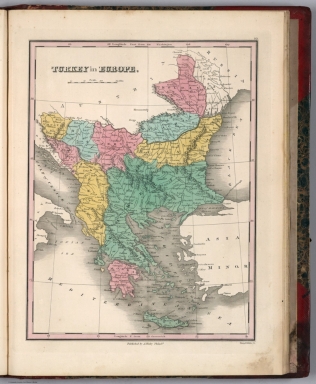
Turkey In Europe. Young & Delleker Sc. Published by A. Finley, Philada. (to accompany) A New General Atlas Comprising a Complete Set of Maps, representing the Grand Divisions Of The Globe ... Philadelphia: Published by Anthony Finley. 1827.
List No
0282.054
Note
Full color map on sheet 35x27. Covers the European lands claimed by the Ottoman Empire in the early 19th century, including the modern day Greece, Macedonia, Albania, Croatia, Bosnia, Serbia, Bulgaria and Moldova. Relief shown pictorially. Prime meridians are Washington and Greenwich. Shows administrative divisions, major cities, forests and rivers.
Author
Finley, Anthony
Full Title
Asia. Young & Delleker Sc. Published by A. Finley, Philada. (to accompany) A New General Atlas Comprising a Complete Set of Maps, representing the Grand Divisions Of The Globe ... Philadelphia: Published by Anthony Finley. 1827.
List No
0282.055
Note
Full color map on sheet 35x27. Relief shown pictorially. Prime meridians are Washington and Greenwich. Shows political divisions, major cities, deserts and rivers.
Author
Finley, Anthony
Full Title
Russia In Asia. Young & Delleker Sc. Published by A. Finley, Philada. (to accompany) A New General Atlas Comprising a Complete Set of Maps, representing the Grand Divisions Of The Globe ... Philadelphia: Published by Anthony Finley. 1827.
List No
0282.056
Note
Full color map on sheet 35x27. Covers from the Black Sea and Arabia east to the Behring Strait, north to the Arctic, and south to Chinese Tartary. Relief shown pictorially. Prime meridians are Washington and Greenwich. Shows major cities, forests and rivers.
Author
Finley, Anthony
Full Title
Turkey In Asia. Young & Delleker Sc. Published by A. Finley, Philada. (to accompany) A New General Atlas Comprising a Complete Set of Maps, representing the Grand Divisions Of The Globe ... Philadelphia: Published by Anthony Finley. 1827.
List No
0282.057
Note
Full color map on sheet 35x27. Covers Georgia, Iraq, Lebanon, Syria, Jordan, Cyprus, Palestine and Israel. Relief shown pictorially. Prime meridians are Washington and Greenwich. Shows boundary between Europe and Asia, major cities, lakes and rivers.
Author
Finley, Anthony
Full Title
Hindoostan. Young & Delleker Sc. Published by A. Finley, Philada. (to accompany) A New General Atlas Comprising a Complete Set of Maps, representing the Grand Divisions Of The Globe ... Philadelphia: Published by Anthony Finley. 1827.
List No
0282.058
Note
Full color map on sheet 35x27. Relief shown pictorially. Prime meridians are Washington and Greenwich. Shows administrative divisions, major cities and rivers.
Author
Finley, Anthony
Full Title
China. Young & Delleker Sc. Published by A. Finley, Philada. (to accompany) A New General Atlas Comprising a Complete Set of Maps, representing the Grand Divisions Of The Globe ... Philadelphia: Published by Anthony Finley. 1827.
List No
0282.059
Note
Full color map on sheet 35x27. Relief shown pictorially. Prime meridians are Washington and Greenwich. Shows administrative divisions, major cities and rivers.
Author
Finley, Anthony
Full Title
Palestine. Young & Delleker Sc. Published by A. Finley, Philada. (to accompany) A New General Atlas Comprising a Complete Set of Maps, representing the Grand Divisions Of The Globe ... Philadelphia: Published by Anthony Finley. 1827.
List No
0282.060
Note
Full color map of Palestine, Israel or the Holy Land. Covers the region from Sidon and Damascus in the north to the southern tip of the Dead Sea or Zoar. Divided with color coding according to the Biblical tribes of Israel. Includes explanation. Relief shown pictorially. Prime meridians are Washington and Greenwich. Shows cities, river systems, deserts and mountains.
Author
Finley, Anthony
Full Title
Africa. Young & Delleker Sc. Published by A. Finley, Philada. (to accompany) A New General Atlas Comprising a Complete Set of Maps, representing the Grand Divisions Of The Globe ... Philadelphia: Published by Anthony Finley. 1827.
List No
0282.061
Note
Full color map on sheet 35x27. Relief shown pictorially. Prime meridians are Washington and Greenwich. Shows countries, major cities, river systems, deserts and mountains. Identifies numerous African tribes, including the Pomba, Jaga, Tbook, Tuareg, Tibboos, Bambara, and the land of Cannibals in Mozambique.
Author
Finley, Anthony
Full Title
Egypt. Young & Delleker Sc. Published by A. Finley, Philada. (to accompany) A New General Atlas Comprising a Complete Set of Maps, representing the Grand Divisions Of The Globe ... Philadelphia: Published by Anthony Finley. 1827.
List No
0282.062
Note
Full color map on sheet 35x27. Relief shown pictorially. Prime meridians are Washington and Greenwich. Shows major cities, river systems, deserts and mountains.
Author
Finley, Anthony
Full Title
Table of the Comparative Heights of the Principal Mountains &c in the World. Young & Delleker Sc. Published by A. Finley, Philada. (to accompany) A New General Atlas Comprising a Complete Set of Maps, representing the Grand Divisions Of The Globe ... Philadelphia: Published by Anthony Finley. 1827.
List No
0282.063
Note
Full color map of the comparative heights of the principal mountains of the world, in relative proximity to one another and divided by continent. Each mountain is numbered and refers to a reference list below the table.
Author
Finley, Anthony
Full Title
Table of the Comparative Lengths of the Principal Rivers throughout the World. Young & Delleker Sc. Published by A. Finley, Philada. (to accompany) A New General Atlas Comprising a Complete Set of Maps, representing the Grand Divisions Of The Globe ... Philadelphia: Published by Anthony Finley. 1827.
List No
0282.064
Note
Full color map of the comparative lengths of the principal rivers of the world, in relative to one another and divided by continent. Each river is numbered and refers to a reference list below the table.
Author
[Reymann, Daniel Gottfried, Flemming, Carl]
Full Title
8 Toenningen
List No
10605.009
Author
[Reymann, Daniel Gottfried, Flemming, Carl]
Full Title
69 Freeren
List No
10605.078
Author
[Reymann, Daniel Gottfried, Flemming, Carl]
Full Title
167 Teplitz
List No
10605.225
Note
Date is the latest date in the series. The range of dates of the sheets is 1822 to 1865
Author
Stieler, Adolf
Full Title
Mittel-ostliches Deutschland oder Bohmen, Mahren und Schlesien &c. entw. v. Ad. St. 1822. revidirt 1827. (upper right margin) Stielers Hand-Atlas No. 23. (to accompany) Hand-Atlas uber alle Theile der Erde, nach dem neuesten Zustande und uber das Weltgebaude.
List No
10777.032
Note
Engraved outline hand color map. Relief shown by hachures.
Author
Stieler, Adolf
Full Title
Galizien, Ungarn mit Sclavonien und Croatien, Siebenburgen und Dalmatien entw. v. Ad. St. Moldau, Walachey, auch Bulgar, Serv, Bosn, entw. v. C.G.R. 1822. Neue in S.W.umgearb. Auflage 1827. (upper right margin) Stielers Hand-Atlas No.35. (to accompany) Hand-Atlas uber alle Theile der Erde, nach dem neuesten Zustande und uber das Weltgebaude.
List No
10777.040
Note
Engraved hand colored outline map. Relief shown by hachures and formlines. Includes note.
Author
Andriveau-Goujon, J.
Full Title
Royaume de France divise en 86 departemens, avec la distance comptee de Paris en lieues de poste aux chefs-lieux de departemens..., comprenant aussi les anciennes provinces. Dressee par J. Goujon. Paris. Chez J. Goujon et J. Andriveau ... 1827. (to accompany) Atlas de choix ou Recueil de cartes de geographie ancienne et moderne.
List No
11124.020
Note
Outline hand color engraved map of Kingdom of France. Shows administrative boundaries, towns, villages, coach routes, postal routes, ports, rivers, lakes, canals, etc. Relief shown by hachures. Includes list of divisions, and explanation to symbols. Prime meridian is Paris.
Author
[Andriveau-Goujon, J., Lapie, M. (Pierre), 1779-1850]
Full Title
Carte generale Turquie d'Europe et de la Grece, dressee par Lapie, Geographe du Roi. Paris, 1827. A Paris chez C. Picquet ... Ecrit par Hacq. (to accompany) Atlas de choix ou Recueil de cartes de geographie ancienne et moderne.
List No
11124.030
Note
Double page outline hand color engraved map of European Turkey and Greece. Shows political and administrative divisions, towns, villages, roads, postal routes, etc. Relief shown by hachures. Prime meridian is Paris.
Author
[Humboldt, Alexander von, 1769-1859, Bonpland, Aime, Brue]
Full Title
XXV. Carte hydrographique de la province du Choco. Communication entre l'Ocean Atlantique et la Mer du Sud tentee dans l'isthme de la Raspadura.
List No
12125.047
Author
[Humboldt, Alexander von, 1769-1859, Bonpland, Aime, Michaelis, F.H.]
Full Title
XXVII. Plan hypsometrique du volcan de Pichincha.
List No
12125.049
Author
Spielmann and Brush
Full Title
Leandert Farm. New York April 1827, Drawn by Thos. R. Ludlam, City Surveyor. Published by Spielmann & Brush, civil engineers, Hoboken, N.J. 1881. (to accompany) Certified copies of original maps of property in New York City.
List No
13338.049
Note
Hand colored cadastral map. Includes notes. Oriented with north to the lower left. Includes color coded list of the landowners.
Author
Spielmann and Brush
Full Title
Leandert Farm. New York April 1827, Drawn by Thos. R. Ludlam, City Surveyor. Published by Spielmann & Brush, civil engineers, Hoboken, N.J. 1881. (to accompany) Certified copies of original maps of property in New York City.
List No
13338.050
Note
Hand colored cadastral map. Includes notes. Oriented with north to the lower left. Includes color coded list of the landowners.
Author
Spielmann and Brush
Full Title
Map of property on Rose Hill Farm and lot of ground opposite belonging to Betram Peter Granger Esquire : situated in the Twelfth Ward of the City of New - York. Taken from maps made in 1812 by Stephen Ludlam. C. S. New York, February 1st., 1827 by Frs. Nicholson. Published by Spielmann & Brush, civil engineers, Hoboken, N.J. 1881. (to accompany) Certified copies of original maps of property in New York City.
List No
13338.063
Note
Hand colored cadastral map. Includes notes and decorative compass rose oriented with north to the left.
Author
Spielmann and Brush
Full Title
Leanderts Farm. See pages 103-104. Registered number 80. New York, June 15th, 1827. Thomas. R. Ludlam, City Surveyor. Published by Spielmann & Brush, civil engineers, Hoboken, N.J. 1881. (to accompany) Certified copies of original maps of property in New York City.
List No
13338.074
Note
Hand colored cadastral map. Includes notes and decorative compass rose oriented with north to the upper margin.
Author
Spielmann and Brush
Full Title
Leanderts Farm. (Continued) See pages 101-102. Registered number 80. New York, June 15th, 1827. Thomas. R. Ludlam, City Surveyor. Published by Spielmann & Brush, civil engineers, Hoboken, N.J. 1881. (to accompany) Certified copies of original maps of property in New York City.
List No
13338.075
Note
Hand colored cadastral map. Includes notes and decorative compass rose oriented with north to the upper margin.
Author
Weiland, C. F. (Carl Ferdinand), 1782-1847
Full Title
Der Oesterreichische Kaiserstaat entworfen und gezeichnet von C. F. Weiland. Weimar, im Verlag des Geograph. Instituts, 1827. C. Metzeroth sc.
List No
14365.008
Note
Map of the Austrian Empire, as of 1827. Shows political boundaries, cities, population, railways, canals, topography, bodies of water, drainage, coastlines and islands. Relief shown with hachures. Includes latitudinal and longitudinal lines, as well as a legend and three bar scales. Hand-colored engraving. Map is 28 x 37 cm, on sheet 45 x 57 cm. (Plate number taken from table of contents.)
Author
Weiland, C. F. (Carl Ferdinand), 1782-1847
Full Title
Schweden und Norwegen entworfen und gezeichnet von C. F. Weiland. Weimar, im Verlag des Geograph. Instituts, 1827.
List No
14365.040
Note
Map of Sweden and Norway, as of 1827. Shows political boundaries, cities, forts, population, railways, topography, bodies of water, drainage, coastlines and islands. Relief shown with hachures. Includes latitudinal and longitudinal lines, as well as a legend and two bar scales. Hand-colored engraving. Map is 39 x 28 cm, on sheet 57 x 45 cm. (Plate number taken from table of contents.)
Author
[Bory de Saint-Vincent, M. (Jean Baptiste GeneviFve Marcellin), 1778-1846, Desmarest, Nicolas, 1725-1815, Vincent]
Full Title
Distribution primitive du genre humain a la surface du Globe, Par M. le Colonel Bory de St. Vincent. Grave par Ambroise Tardieu. (A Paris, Chez Mme. veuve Agasse, Imprimeur-Libraire, rue des Poitevins, no. 6. M.DCCCXXVII)
List No
1801.001
Note
Hand col. engraved map. Relief shown by hachures.
Author
[Bory de Saint-Vincent, M. (Jean Baptiste GeneviFve Marcellin), 1778-1846, Desmarest, Nicolas, 1725-1815, Vincent]
Full Title
Carte des glaces, circompolaires boreales. Grave par Berthe. (A Paris, Chez Mme. veuve Agasse, Imprimeur-Libraire, rue des Poitevins, no. 6. M.DCCCXXVII)
List No
1801.002
Note
Engraved map. Shows routes of Phipps 1773, Hearn 1772 and Cook 1776-1780.
Author
[Bory de Saint-Vincent, M. (Jean Baptiste GeneviFve Marcellin), 1778-1846, Desmarest, Nicolas, 1725-1815, Vincent]
Full Title
Carte des glaces, circompolaires australes. Grave par Berthe. (A Paris, Chez Mme. veuve Agasse, Imprimeur-Libraire, rue des Poitevins, no. 6. M.DCCCXXVII)
List No
1801.003
Note
Engraved map. Shows routes of Cook, Furneaux and Bouvet, 1738-1780. David Rumsey Collection copy has annotations in pencil.
Author
[Bory de Saint-Vincent, M. (Jean Baptiste GeneviFve Marcellin), 1778-1846, Desmarest, Nicolas, 1725-1815, Vincent]
Full Title
Theorie des vents (Amerique. A Paris, Chez Mme. veuve Agasse, Imprimeur-Libraire, rue des Poitevins, no. 6. M.DCCCXXVII)
List No
1801.004
Note
Engraved map. Prime meridians: Ferro and Paris.
Author
[Bory de Saint-Vincent, M. (Jean Baptiste GeneviFve Marcellin), 1778-1846, Desmarest, Nicolas, 1725-1815, Vincent]
Full Title
Theorie des vents (Afrique, Ocean Atlantique, Grand Ocean Antarctique). Grave par Berthe. (A Paris, Chez Mme. veuve Agasse, Imprimeur-Libraire, rue des Poitevins, no. 6. M.DCCCXXVII)
List No
1801.005
Note
Engraved map. Covers Africa, the Middle East, South Asia and parts of Brazil, the Atlantic and Indian oceans. Prime meridians: Ferro and Paris.
Author
[Bory de Saint-Vincent, M. (Jean Baptiste GeneviFve Marcellin), 1778-1846, Desmarest, Nicolas, 1725-1815, Vincent]
Full Title
Theorie des vents (Asie, Ocean Indien, Ocean Pacifique, Ocean Antarctique). Grave par Berthe. (A Paris, Chez Mme. veuve Agasse, Imprimeur-Libraire, rue des Poitevins, no. 6. M.DCCCXXVII)
List No
1801.006
Note
Engraved map. Covers the Indian Ocean, Australia and parts of Asia, Africa and the Pacific. Prime meridians: Ferro and Paris.
Author
[Bory de Saint-Vincent, M. (Jean Baptiste GeneviFve Marcellin), 1778-1846, Desmarest, Nicolas, 1725-1815, Vincent]
Full Title
Theorie des vents (Ocean Pacifique). Grave par Berthe. (A Paris, Chez Mme. veuve Agasse, Imprimeur-Libraire, rue des Poitevins, no. 6. M.DCCCXXVII)
List No
1801.007
Note
Engraved map. Covers Australia, New Zealand and part of the Pacific. Prime meridians: Ferro and Paris.
Author
[Bory de Saint-Vincent, M. (Jean Baptiste GeneviFve Marcellin), 1778-1846, Desmarest, Nicolas, 1725-1815, Vincent]
Full Title
Carte du courant qui sort par le Canal de Bahama, appele Gulf-Stream. Grave par Berthe. (A Paris, Chez Mme. veuve Agasse, Imprimeur-Libraire, rue des Poitevins, no. 6. M.DCCCXXVII)
List No
1801.008
Note
Engraved map. Relief shown by hachures. Inset: Route des harengs. Prime meridians: Ferro and Paris. David Rumsey Collection copy has "p. 38" added in pencil.
Author
[Bory de Saint-Vincent, M. (Jean Baptiste GeneviFve Marcellin), 1778-1846, Desmarest, Nicolas, 1725-1815, Vincent]
Full Title
Carte et coupe du Canal de la Manche. Bonne fil. delt. (A Paris, Chez Mme. veuve Agasse, Imprimeur-Libraire, rue des Poitevins, no. 6. M.DCCCXXVII)
List No
1801.009
Note
Engraved map. Relief shown by hachures; depths by isolines. Profile shown as inset at top. Prime meridians: Ferro and Paris. David Rumsey Collection copy has "p. 86" added in pencil.
Author
[Bory de Saint-Vincent, M. (Jean Baptiste GeneviFve Marcellin), 1778-1846, Desmarest, Nicolas, 1725-1815, Vincent]
Full Title
Bassin du Golfe de Botnie. Grave par Ambroise Tardieu. (A Paris, Chez Mme. veuve Agasse, Imprimeur-Libraire, rue des Poitevins, no. 6. M.DCCCXXVII)
List No
1801.010
Note
Engraved map. Relief shown by hachures. Prime meridians: Ferro and Paris. David Rumsey Collection copy has annotations in pencil.
Author
[Bory de Saint-Vincent, M. (Jean Baptiste GeneviFve Marcellin), 1778-1846, Desmarest, Nicolas, 1725-1815, Vincent]
Full Title
Plaine de Montbrison. A. Poiret sculp. (A Paris, Chez Mme. veuve Agasse, Imprimeur-Libraire, rue des Poitevins, no. 6. M.DCCCXXVII)
List No
1801.011
Note
Engraved map. Relief shown by hachures. Covers part of the Loire Valley. David Rumsey Collection copy has annotations in pencil.
Author
[Bory de Saint-Vincent, M. (Jean Baptiste GeneviFve Marcellin), 1778-1846, Desmarest, Nicolas, 1725-1815, Vincent]
Full Title
Ponts naturels. Grave par Ambroise Tardieu. (A Paris, Chez Mme. veuve Agasse, Imprimeur-Libraire, rue des Poitevins, no. 6. M.DCCCXXVII)
List No
1801.012
Note
Five engraved maps on 1 sheet. Relief shown by hachures. Contents: Pont Naturel sur la Riviere d'Ardeche, avec le Gouffre de la Goutte, ancien Vivarais--Dept. de l'Ardeche -- Les rivieres de Drome et d'Aure se perdent dans la Fosse de Soucy, et repairaissent a Port en Bessin, Dept. du Calvados -- La Riviere de Lesse se perd au Trou de Ham, et repairait a Ham sur Lesse, Dept. de Sambre et Meuse -- La Riviere Noire se perd pres la Forge S. Roch, et reparait a Nisme, Dept. de Sambre et Meuse -- Une des sources de la Riviere d'Arize se perd dans la ceinture d'un vallon ferme pres d'Alxein ... Dept. de l'Arriege.
Author
[Bory de Saint-Vincent, M. (Jean Baptiste GeneviFve Marcellin), 1778-1846, Desmarest, Nicolas, 1725-1815, Vincent]
Full Title
Environs d'Angouleme, et cours de la Touvre. Grave par Ambroise Tardieu. (A Paris, Chez Mme. veuve Agasse, Imprimeur-Libraire, rue des Poitevins, no. 6. M.DCCCXXVII)
List No
1801.013
Note
Engraved map. Relief shown by hachures. David Rumsey Collection copy: "Charente" added in pencil below title.
Author
[Bory de Saint-Vincent, M. (Jean Baptiste GeneviFve Marcellin), 1778-1846, Desmarest, Nicolas, 1725-1815, Vincent]
Full Title
Carte des montagnes coupees par des rivieres, situees en Virginie et en Pensylvanie. Grave par Berthe. (A Paris, Chez Mme. veuve Agasse, Imprimeur-Libraire, rue des Poitevins, no. 6. M.DCCCXXVII)
List No
1801.014
Note
Engraved map. Relief shown by hachures.
Author
[Bory de Saint-Vincent, M. (Jean Baptiste GeneviFve Marcellin), 1778-1846, Desmarest, Nicolas, 1725-1815, Vincent]
Full Title
Cours de la Charente avec ses oscillations depuis Civray jusqu'a Aulnac. A. Poiret sculp. (A Paris, Chez Mme. veuve Agasse, Imprimeur-Libraire, rue des Poitevins, no. 6. M.DCCCXXVII)
List No
1801.015
Note
Engraved map. Relief shown by hachures.
Author
[Bory de Saint-Vincent, M. (Jean Baptiste GeneviFve Marcellin), 1778-1846, Desmarest, Nicolas, 1725-1815, Vincent]
Full Title
(Cours de la Charente avec ses oscillations depuis Ballan jusqu'a Cuchet). A. Poiret sculp. (A Paris, Chez Mme. veuve Agasse, Imprimeur-Libraire, rue des Poitevins, no. 6. M.DCCCXXVII)
List No
1801.016
Note
Engraved map. Relief shown by hachures. Includes 3 profiles: Profil sur la Ligne AB ... CD ... EF.
Author
[Bory de Saint-Vincent, M. (Jean Baptiste GeneviFve Marcellin), 1778-1846, Desmarest, Nicolas, 1725-1815, Vincent]
Full Title
Plan incline et bords escarpes de deux oscillations de la Seine. Grave par Berthe, Rue St. Jacques, No. 66. (A Paris, Chez Mme. veuve Agasse, Imprimeur-Libraire, rue des Poitevins, no. 6. M.DCCCXXVII)
List No
1801.017
Note
Engraved map. Relief shown by hachures. Oriented with north toward upper right.
Author
[Bory de Saint-Vincent, M. (Jean Baptiste GeneviFve Marcellin), 1778-1846, Desmarest, Nicolas, 1725-1815, Vincent]
Full Title
Plan du confluent de la Marne. Grave par Ambroise Tardieu. (A Paris, Chez Mme. veuve Agasse, Imprimeur-Libraire, rue des Poitevins, no. 6. M.DCCCXXVII)
List No
1801.018
Note
Engraved map. Relief shown by hachures.
Author
[Bory de Saint-Vincent, M. (Jean Baptiste GeneviFve Marcellin), 1778-1846, Desmarest, Nicolas, 1725-1815, Vincent]
Full Title
Plan du confluent de la Seine et de l'Oise. Grave par Ambroise Tardieu. (A Paris, Chez Mme. veuve Agasse, Imprimeur-Libraire, rue des Poitevins, no. 6. M.DCCCXXVII)
List No
1801.019
Note
Engraved map. Relief shown by hachures.
Author
[Bory de Saint-Vincent, M. (Jean Baptiste GeneviFve Marcellin), 1778-1846, Desmarest, Nicolas, 1725-1815, Vincent]
Full Title
Confluences de la Loire du Cher et de l'Indre, avec le detail des isles qui s'y trouvent comprises. (A Paris, Chez Mme. veuve Agasse, Imprimeur-Libraire, rue des Poitevins, no. 6. M.DCCCXXVII)
List No
1801.020
Note
Hand col. Engraved map. Relief shown by hachures. In the vicinity of Tours. David Rumsey Collection copy has "Indre et Loire" and "A. Poiret Sc." added in pencil.
Author
[Bory de Saint-Vincent, M. (Jean Baptiste GeneviFve Marcellin), 1778-1846, Desmarest, Nicolas, 1725-1815, Vincent]
Full Title
Carte des bouches du Rhone. Gravee par Berthe. (A Paris, Chez Mme. veuve Agasse, Imprimeur-Libraire, rue des Poitevins, no. 6. M.DCCCXXVII)
List No
1801.021
Note
Hand col. Engraved map. Relief shown by hachures. Includes inset of area from Vallabregues to Avignon.
Author
[Bory de Saint-Vincent, M. (Jean Baptiste GeneviFve Marcellin), 1778-1846, Desmarest, Nicolas, 1725-1815, Vincent]
Full Title
Le Bec d'Ambes, confluent de la Garonne et de la Dordogne, terrains d'alluvions. (A Paris, Chez Mme. veuve Agasse, Imprimeur-Libraire, rue des Poitevins, no. 6. M.DCCCXXVII)
List No
1801.022
Note
Hand col. Engraved map. Relief shown by hachures. David Rumsey Collection copy has the name "Bordeaux" added in pencil.
Author
[Bory de Saint-Vincent, M. (Jean Baptiste GeneviFve Marcellin), 1778-1846, Desmarest, Nicolas, 1725-1815, Vincent]
Full Title
Carte du Morvan. A. Poiret sculp. (A Paris, Chez Mme. veuve Agasse, Imprimeur-Libraire, rue des Poitevins, no. 6. M.DCCCXXVII)
List No
1801.023
Note
Hand col. engraved map. Relief shown by hachures.
Author
[Bory de Saint-Vincent, M. (Jean Baptiste GeneviFve Marcellin), 1778-1846, Desmarest, Nicolas, 1725-1815, Vincent]
Full Title
Carte des limites de l'ancienne terre du Morvan. A. Poiret sculp. (A Paris, Chez Mme. veuve Agasse, Imprimeur-Libraire, rue des Poitevins, no. 6. M.DCCCXXVII)
List No
1801.024
Note
Hand col. Engraved map. Relief shown by hachures. David Rumsey Collection copy has words "East of Paris" added in pencil.
Author
[Bory de Saint-Vincent, M. (Jean Baptiste GeneviFve Marcellin), 1778-1846, Desmarest, Nicolas, 1725-1815, Vincent]
Full Title
Carte mineralogique de la Saxe. Distribuee par massifs. Gravee par Ambroise Tardieu. (A Paris, Chez Mme. veuve Agasse, Imprimeur-Libraire, rue des Poitevins, no. 6. M.DCCCXXVII)
List No
1801.025
Note
Hand col. Engraved map. Relief shown by hachures. Shows geology. David Rumsey Collection copy has "p. 86" added in pencil.
Author
[Bory de Saint-Vincent, M. (Jean Baptiste GeneviFve Marcellin), 1778-1846, Desmarest, Nicolas, 1725-1815, Vincent]
Full Title
Carte du Plateau de St. Pierre. Releve et dessinee par Mr. le Colonel Bory de St. Vincent en 1819. Grave par Ambroise Tardieu. (A Paris, Chez Mme. veuve Agasse, Imprimeur-Libraire, rue des Poitevins, no. 6. M.DCCCXXVII)
List No
1801.026
Note
Engraved map. Relief shown by hachures. Shows buildings, fields, etc.
Author
[Bory de Saint-Vincent, M. (Jean Baptiste GeneviFve Marcellin), 1778-1846, Desmarest, Nicolas, 1725-1815, Vincent]
Full Title
Coupe perpendiculaire d'un point du Plateau de St. Pierre. Grande entree sous le Fort St. Pierre, vue de la route de Kanne. Entree de cryptes sous Lichtenberg, avec les orgues geologiques qu'on y voit. Dessine par Bory de St. Vincent. Grave par Ambroise Tardieu. (A Paris, Chez Mme. veuve Agasse, Imprimeur-Libraire, rue des Poitevins, no. 6. M.DCCCXXVII)
List No
1801.027
Note
Engraved cross section and 2 views. Numbered 1-3.
Author
[Bory de Saint-Vincent, M. (Jean Baptiste GeneviFve Marcellin), 1778-1846, Desmarest, Nicolas, 1725-1815, Vincent]
Full Title
Plan du Mont Gibel, anciennement Mont Etna. (with) Isole di Lipari. (with) Coupe du Mont Etna. (A Paris, Chez Mme. veuve Agasse, Imprimeur-Libraire, rue des Poitevins, no. 6. M.DCCCXXVII)
List No
1801.029
Note
Engraved map with inset and inset profile. Relief shown by hachures.
Author
[Bory de Saint-Vincent, M. (Jean Baptiste GeneviFve Marcellin), 1778-1846, Desmarest, Nicolas, 1725-1815, Vincent]
Full Title
Carte du Monte Vesuve. Grave par Ambroise Tardieu. (A Paris, Chez Mme. veuve Agasse, Imprimeur-Libraire, rue des Poitevins, no. 6. M.DCCCXXVII)
List No
1801.030
Note
Engraved map. Relief shown by hachures.
Author
[Bory de Saint-Vincent, M. (Jean Baptiste GeneviFve Marcellin), 1778-1846, Desmarest, Nicolas, 1725-1815, Vincent]
Full Title
Partie orientale de l'ile de Mascareigne. Grave par Ambroise Tardieu. (A Paris, Chez Mme. veuve Agasse, Imprimeur-Libraire, rue des Poitevins, no. 6. M.DCCCXXVII)
List No
1801.031
Note
Engraved map. Relief shown by hachures.
Author
[Bory de Saint-Vincent, M. (Jean Baptiste GeneviFve Marcellin), 1778-1846, Desmarest, Nicolas, 1725-1815, Vincent]
Full Title
Champs Phlegreens. Grave par Ambroise Tardieu. (A Paris, Chez Mme. veuve Agasse, Imprimeur-Libraire, rue des Poitevins, no. 6. M.DCCCXXVII)
List No
1801.032
Note
Engraved map. Relief shown by hachures. David Rumsey Collection copy includes additions and annotations (in English) in pencil.
Author
[Bory de Saint-Vincent, M. (Jean Baptiste GeneviFve Marcellin), 1778-1846, Desmarest, Nicolas, 1725-1815, Vincent]
Full Title
Comte d'Antrim. (with) Vue du Cap de Doon dans l'isle Raghery. Poiret sculp. (A Paris, Chez Mme. veuve Agasse, Imprimeur-Libraire, rue des Poitevins, no. 6. M.DCCCXXVII)
List No
1801.037
Note
Engraved map. Relief shown by hachures. Shows roads, harbors, submerged limestone, columnar basalt, currents, etc. David Rumsey Collection copy includes annotations in pencil.
Author
[Bory de Saint-Vincent, M. (Jean Baptiste GeneviFve Marcellin), 1778-1846, Desmarest, Nicolas, 1725-1815, Vincent]
Full Title
Lacs volcaniques de la IIe. et IIIe. epoque. Grave par Berthe. (A Paris, Chez Mme. veuve Agasse, Imprimeur-Libraire, rue des Poitevins, no. 6. M.DCCCXXVII)
List No
1801.042
Note
Three engraved maps. Relief shown by hachures. Contents: Lac de la Cassiere et Lac d'Aidat de la IIIe. epoque -- Lac de Guery, IIe. Epoque -- Lacs de la Moussiniere et de Bourboulouse, de la IIe. epoque. David Rumsey Collection copy has "p. 87" added in pencil.
Author
[Bory de Saint-Vincent, M. (Jean Baptiste GeneviFve Marcellin), 1778-1846, Desmarest, Nicolas, 1725-1815, Vincent]
Full Title
Lacs volcaniques de la Iere, IIeme. et IIIeme. epoques. Grave par Ambroise Tardieu. (A Paris, Chez Mme. veuve Agasse, Imprimeur-Libraire, rue des Poitevins, no. 6. M.DCCCXXVII)
List No
1801.043
Note
Six engraved maps. Relief shown by hachures. Contents: Lac Paven, IIIe. epoque -- Lac Chambon, IIIe. epoque -- Lac de Servieres, Ie. epoque -- Lac de St. Front, IIe. epoque -- Lac de St. Paulien, IIe. epoque -- Lac du Bouchet, IIe. epoque.
Author
[Bory de Saint-Vincent, M. (Jean Baptiste GeneviFve Marcellin), 1778-1846, Desmarest, Nicolas, 1725-1815, Vincent]
Full Title
Volcans. 2e. epoque. Culots avec les courans depouilles de Scories places sur les sommets de tous les bords des vallons, Ancien Velay, Departnt. de la Haute Loire. Grave par Berthe, Rue St. Jacques, No. 66. (A Paris, Chez Mme. veuve Agasse, Imprimeur-Libraire, rue des Poitevins, no. 6. M.DCCCXXVII)
List No
1801.044
Note
Engraved map. Relief shown by hachures.
Author
[Bory de Saint-Vincent, M. (Jean Baptiste GeneviFve Marcellin), 1778-1846, Desmarest, Nicolas, 1725-1815, Vincent]
Full Title
Volcans IIIeme. et derniere epoque. Environs de Clermont, crateres de Pariou et de Graveniere, avec leurs courans de lave couverts de Scories, et l'indication des Sources, aux extremites de ces courans. Grave par Ambroise Tardieu. (A Paris, Chez Mme. veuve Agasse, Imprimeur-Libraire, rue des Poitevins, no. 6. M.DCCCXXVII)
List No
1801.045
Note
Engraved map. Relief shown by hachures.
Author
[Bory de Saint-Vincent, M. (Jean Baptiste GeneviFve Marcellin), 1778-1846, Desmarest, Nicolas, 1725-1815, Vincent]
Full Title
Carte conjecturale de l'Atlantide d'apres le Colonel Bory de St. Vincent, dans ses Essais sur les Iles Fortunees. Grave par Berthe. (A Paris, Chez Mme. veuve Agasse, Imprimeur-Libraire, rue des Poitevins, no. 6. M.DCCCXXVII)
List No
1801.046
Note
Engraved map. Relief shown by hachures. Shows modern and ancient names. Prime meridian: Paris. David Rumsey Collection copy has "p. 104 to 108" added in pencil.
Author
[Bory de Saint-Vincent, M. (Jean Baptiste GeneviFve Marcellin), 1778-1846, Desmarest, Nicolas, 1725-1815, Vincent]
Full Title
Carte physique de la France. (Dessinee par) Bory de St. Vincent. Grave par Berthe. (A Paris, Chez Mme. veuve Agasse, Imprimeur-Libraire, rue des Poitevins, no. 6. M.DCCCXXVII)
List No
1801.047
Note
Engraved map. Relief shown by hachures. Hand col. to show "Versant celtique, versant belgique ou rhenan, versant mediterraneen, versant aquitainique, versant cantabrique." Also shows northernmost "ligne des vignes" and "ligne des oliviers," etc. Prime meridians: (Ferro) and Paris.
Author
[Perrot, A. M. (Aristide Michel), 1793-1879, Vandermaelen, Philippe, 1795-1869]
Full Title
Tableau comparatif des principales hauteurs du globe. D'apres A.M. Perrot. (Dresse par Ph. Vandermaelen, lithographie par H. Ode. Premier partie. - Europe. Bruxelles. 1827)
List No
2212.001
Note
Hand col. lithograph. Key to peaks at bottom with elevations.
Author
Vandermaelen, Philippe, 1795-1869
Full Title
Carte d'assemblage de l'Europe. (Dresse par Ph. Vandermaelen, lithographie par H. Ode. Premier partie. - Europe. Bruxelles. 1827)
List No
2212.002
Note
Hand col. lithographed index map. Relief shown by hachures. Prime meridian: Paris.
Author
Vandermaelen, Philippe, 1795-1869
Full Title
Partie de la Suede et de la Norwege. Europe no. 1. (Dresse par Ph. Vandermaelen, lithographie par H. Ode. Premier partie. - Europe. Bruxelles. 1827)
List No
2212.003
Note
Hand col. lithographed map. Relief shown by hachures. Prime meridian: Paris.
Author
Vandermaelen, Philippe, 1795-1869
Full Title
Islande. Europe no. 1 bis. (Dresse par Ph. Vandermaelen, lithographie par H. Ode. Premier partie. - Europe. Bruxelles. 1827)
List No
2212.004
Note
Hand col. lithographed map. Relief shown by hachures. Prime meridian: Paris.
Author
Vandermaelen, Philippe, 1795-1869
Full Title
Spitsberg. Europe no. 1 ter. (Dresse par Ph. Vandermaelen, lithographie par H. Ode. Premier partie. - Europe. Bruxelles. 1827)
List No
2212.005
Note
Hand col. lithographed map. Relief shown by hachures. Prime meridian: Paris.
Author
Vandermaelen, Philippe, 1795-1869
Full Title
Partie de la Russie d'Europe. Europe no. 2. (Dresse par Ph. Vandermaelen, lithographie par H. Ode. Premier partie. - Europe. Bruxelles. 1827)
List No
2212.006
Note
Hand col. lithographed map. Relief shown by hachures. Prime meridian: Paris.
Author
Vandermaelen, Philippe, 1795-1869
Full Title
Partie de la Norwege. Europe no. 3. (Dresse par Ph. Vandermaelen, lithographie par H. Ode. Premier partie. - Europe. Bruxelles. 1827)
List No
2212.007
Note
Hand col. lithographed map. Relief shown by hachures. Covers also "Iles Faeroes" and "Iles Schetland." Prime meridian: Paris.
Author
Vandermaelen, Philippe, 1795-1869
Full Title
Partie de la Suede et de la Norwege. Europe no. 4. (Dresse par Ph. Vandermaelen, lithographie par H. Ode. Premier partie. - Europe. Bruxelles. 1827)
List No
2212.008
Note
Hand col. lithographed map. Relief shown by hachures. Prime meridian: Paris.
Author
Vandermaelen, Philippe, 1795-1869
Full Title
Partie de la Russie d'Europe. Europe no. 5. (Dresse par Ph. Vandermaelen, lithographie par H. Ode. Premier partie. - Europe. Bruxelles. 1827)
List No
2212.009
Note
Hand col. lithographed map. Relief shown by hachures. Prime meridian: Paris.
Author
Vandermaelen, Philippe, 1795-1869
Full Title
Partie de la Russie d'Europe. Europe no. 6. (Dresse par Ph. Vandermaelen, lithographie par H. Ode. Premier partie. - Europe. Bruxelles. 1827)
List No
2212.010
Note
Hand col. lithographed map. Relief shown by hachures. Prime meridian: Paris.
Author
Vandermaelen, Philippe, 1795-1869
Full Title
Partie de l'Angleterre. Europe no. 7. (Dresse par Ph. Vandermaelen, lithographie par H. Ode. Premier partie. - Europe. Bruxelles. 1827)
List No
2212.011
Note
Hand col. lithographed map. Relief shown by hachures. Covers Scotland, Northern Ireland, and adjacent parts of Ireland and England. Prime meridian: Paris.
Author
Vandermaelen, Philippe, 1795-1869
Full Title
Danemarc. Europe no. 8. (Dresse par Ph. Vandermaelen, lithographie par H. Ode. Premier partie. - Europe. Bruxelles. 1827)
List No
2212.012
Note
Hand col. lithographed map. Relief shown by hachures. Covers also southern parts of Norway and Sweden. Prime meridian: Paris.
Author
Vandermaelen, Philippe, 1795-1869
Full Title
Partie de la Russie. Europe no. 9. (Dresse par Ph. Vandermaelen, lithographie par H. Ode. Premier partie. - Europe. Bruxelles. 1827)
List No
2212.013
Note
Hand col. lithographed map. Relief shown by hachures. Covers also the Baltic States, East Prussia, Gotland and parts of eastern Sweden. Prime meridian: Paris.
Author
Vandermaelen, Philippe, 1795-1869
Full Title
Partie de la Russie d'Europe. Europe no. 10. (Dresse par Ph. Vandermaelen, lithographie par H. Ode. Premier partie. - Europe. Bruxelles. 1827)
List No
2212.014
Note
Hand col. lithographed map. Relief shown by hachures. Prime meridian: Paris.
Author
Vandermaelen, Philippe, 1795-1869
Full Title
Partie de la Russie d'Europe. Europe no. 11. (Dresse par Ph. Vandermaelen, lithographie par H. Ode. Premier partie. - Europe. Bruxelles. 1827)
List No
2212.015
Note
Hand col. lithographed map. Relief shown by hachures. Prime meridian: Paris.
Author
Vandermaelen, Philippe, 1795-1869
Full Title
Partie de l'Angleterre. Europe no. 12. (Dresse par Ph. Vandermaelen, lithographie par H. Ode. Premier partie. - Europe. Bruxelles. 1827)
List No
2212.016
Note
Hand col. lithographed map. Relief shown by hachures. Covers portions of England, Wales, Ireland and northwestern France. Prime meridian: Paris.
Author
Vandermaelen, Philippe, 1795-1869
Full Title
Royaume des Pays-Bas. Europe no. 13. (Dresse par Ph. Vandermaelen, lithographie par H. Ode. Premier partie. - Europe. Bruxelles. 1827)
List No
2212.017
Note
Hand col. lithographed map. Relief shown by hachures. Covers also Luxembourg and parts of France and Germany. Prime meridian: Paris.
Author
Vandermaelen, Philippe, 1795-1869
Full Title
Partie de l'Allemagne. Europe no. 14. (Dresse par Ph. Vandermaelen, lithographie par H. Ode. Premier partie. - Europe. Bruxelles. 1827)
List No
2212.018
Note
Hand col. lithographed map. Relief shown by hachures. Prime meridian: Paris.
Author
Vandermaelen, Philippe, 1795-1869
Full Title
Partie de la Russie d'Europe. Europe no. 15. (Dresse par Ph. Vandermaelen, lithographie par H. Ode. Premier partie. - Europe. Bruxelles. 1827)
List No
2212.019
Note
Hand col. lithographed map. Relief shown by hachures. Prime meridian: Paris.
Author
Vandermaelen, Philippe, 1795-1869
Full Title
Partie de la Russie d'Europe. Europe no. 16. (Dresse par Ph. Vandermaelen, lithographie par H. Ode. Premier partie. - Europe. Bruxelles. 1827)
List No
2212.020
Note
Hand col. lithographed map. Relief shown by hachures. Prime meridian: Paris.
Author
Vandermaelen, Philippe, 1795-1869
Full Title
Partie de la Russie. Europe no. 17. (Dresse par Ph. Vandermaelen, lithographie par H. Ode. Premier partie. - Europe. Bruxelles. 1827)
List No
2212.021
Note
Hand col. lithographed map. Relief shown by hachures. Prime meridian: Paris.
Author
Vandermaelen, Philippe, 1795-1869
Full Title
Partie de l'Espagne. Europe no. 18. (Dresse par Ph. Vandermaelen, lithographie par H. Ode. Premier partie. - Europe. Bruxelles. 1827)
List No
2212.022
Note
Hand col. lithographed map. Relief shown by hachures. Covers also part of northwestern France. Prime meridian: Paris.
Author
Vandermaelen, Philippe, 1795-1869
Full Title
Partie de la France. Europe no. 19. (Dresse par Ph. Vandermaelen, lithographie par H. Ode. Premier partie. - Europe. Bruxelles. 1827)
List No
2212.023
Note
Hand col. lithographed map. Relief shown by hachures. Covers also adjacent parts of Spain, Switzerland and Italy. Prime meridian: Paris.
Author
Vandermaelen, Philippe, 1795-1869
Full Title
Partie de l'Italie. Europe no. 20. (Dresse par Ph. Vandermaelen, lithographie par H. Ode. Premier partie. - Europe. Bruxelles. 1827)
List No
2212.024
Note
Hand col. lithographed map. Relief shown by hachures. Covers also Slovenia, Croatia, and parts of Bosnia, Corsica, Serbia, Switzerland, Austria and Hungary. Prime meridian: Paris.
Author
Vandermaelen, Philippe, 1795-1869
Full Title
Partie de la Turquie. Europe no. 21. (Dresse par Ph. Vandermaelen, lithographie par H. Ode. Premier partie. - Europe. Bruxelles. 1827)
List No
2212.025
Note
Hand col. lithographed map. Relief shown by hachures. Covers Serbia and parts of Romania, Bulgaria, Macedonia, Albania, Montenegro and Hungary. Prime meridian: Paris.
Author
Vandermaelen, Philippe, 1795-1869
Full Title
Partie de la Russie. Europe no. 22. (Dresse par Ph. Vandermaelen, lithographie par H. Ode. Premier partie. - Europe. Bruxelles. 1827)
List No
2212.026
Note
Hand col. lithographed map. Relief shown by hachures. Covers parts of Bulgaria, Romania, Moldova, Ukraine and Russia. Prime meridian: Paris.
Author
Vandermaelen, Philippe, 1795-1869
Full Title
Partie de la Russie d'Europe. Europe no. 23. (Dresse par Ph. Vandermaelen, lithographie par H. Ode. Premier partie. - Europe. Bruxelles. 1827)
List No
2212.027
Note
Hand col. lithographed map. Relief shown by hachures. Covers parts of Russia and Georgia. Prime meridian: Paris.
Author
Vandermaelen, Philippe, 1795-1869
Full Title
Partie de l'Espagne et Portugal. Europe no. 24. (Dresse par Ph. Vandermaelen, lithographie par H. Ode. Premier partie. - Europe. Bruxelles. 1827)
List No
2212.028
Note
Hand col. lithographed map. Relief shown by hachures. Prime meridian: Paris.
Author
Vandermaelen, Philippe, 1795-1869
Full Title
Iles Baleares et Sardaigne. Europe no. 25. (Dresse par Ph. Vandermaelen, lithographie par H. Ode. Premier partie. - Europe. Bruxelles. 1827)
List No
2212.029
Note
Hand col. lithographed map. Relief shown by hachures. Covers also part of Spanish coast, southern Corsica and coastal Algeria and Tunisia. Prime meridian: Paris.
Author
Vandermaelen, Philippe, 1795-1869
Full Title
Naples et Sicile. Europe no. 26. (Dresse par Ph. Vandermaelen, lithographie par H. Ode. Premier partie. - Europe. Bruxelles. 1827)
List No
2212.030
Note
Hand col. lithographed map. Relief shown by hachures. Covers also Malta and parts of Tunisia, Albania and Greece. Prime meridian: Paris.
Author
Vandermaelen, Philippe, 1795-1869
Full Title
Grece. Europe no. 27. (Dresse par Ph. Vandermaelen, lithographie par H. Ode. Premier partie. - Europe. Bruxelles. 1827)
List No
2212.031
Note
Hand col. lithographed map. Relief shown by hachures. Covers also parts of Albania, Macedonia, Bulgaria and western Turkey. Prime meridian: Paris.
Author
Vandermaelen, Philippe, 1795-1869
Full Title
Carte d'assemblage de l'Asie. (Dresse par Ph. Vandermaelen, lithographie par H. Ode. Deuxieme partie. - Asie. Bruxelles. 1827)
List No
2212.032
Note
Hand col. lithographed index map. Relief shown by hachures. Includes inset for Bering Sea area. Prime meridian: Paris.
Author
Vandermaelen, Philippe, 1795-1869
Full Title
Partie de la Russie d'Asie. Asie no. 1. (Dresse par Ph. Vandermaelen, lithographie par H. Ode. Deuxieme partie. - Asie. Bruxelles. 1827)
List No
2212.033
Note
Hand col. lithographed map. Relief shown pictorially. Covers part of Novaya Zemlya. Prime meridian: Paris.
Author
Vandermaelen, Philippe, 1795-1869
Full Title
Partie de la Russie d'Asie. Asie no. 2. (Dresse par Ph. Vandermaelen, lithographie par H. Ode. Deuxieme partie. - Asie. Bruxelles. 1827)
List No
2212.034
Note
Hand col. lithographed map. Covers the Taymyr Peninsula region. Shows explorers' routes. Prime meridian: Paris.
Author
Vandermaelen, Philippe, 1795-1869
Full Title
Partie de la Russie d'Asie. Asie no. 3. (Dresse par Ph. Vandermaelen, lithographie par H. Ode. Deuxieme partie. - Asie. Bruxelles. 1827)
List No
2212.035
Note
Hand col. lithographed map. Covers the Taymyr Peninsula-Laptev Sea region. Shows explorers' routes. Prime meridian: Paris.
Author
Vandermaelen, Philippe, 1795-1869
Full Title
Partie de la Russie d'Asie. Asie no. 4. (Dresse par Ph. Vandermaelen, lithographie par H. Ode. Deuxieme partie. - Asie. Bruxelles. 1827)
List No
2212.036
Note
Hand col. lithographed map. Covers the Lena Estuary-New Siberian Islands region. Shows explorers' routes. Prime meridian: Paris.
Author
Vandermaelen, Philippe, 1795-1869
Full Title
Partie de la Russie d'Asie. Asie no. 5. (Dresse par Ph. Vandermaelen, lithographie par H. Ode. Deuxieme partie. - Asie. Bruxelles. 1827)
List No
2212.037
Note
Hand col. lithographed map. Relief shown pictorially. Covers the Kara Sea region. Shows explorers' routes. Prime meridian: Paris.
Author
Vandermaelen, Philippe, 1795-1869
Full Title
Partie de la Russie d'Asie. Asie no. 6. (Dresse par Ph. Vandermaelen, lithographie par H. Ode. Deuxieme partie. - Asie. Bruxelles. 1827)
List No
2212.038
Note
Hand col. lithographed map. Covers the Obskaya Gulf-Gydanskiy Peninsula-Yenisey River region. Shows explorers' routes. Prime meridian: Paris. "P" in lower left corner.
Author
Vandermaelen, Philippe, 1795-1869
Full Title
Partie de la Russie d'Asie. Asie no. 7. (Dresse par Ph. Vandermaelen, lithographie par H. Ode. Deuxieme partie. - Asie. Bruxelles. 1827)
List No
2212.039
Note
Hand col. lithographed map. Relief shown pictorially. Covers part of northern Siberia. Prime meridian: Paris.
Author
Vandermaelen, Philippe, 1795-1869
Full Title
Partie de la Russie d'Asie. Asie no. 8. (Dresse par Ph. Vandermaelen, lithographie par H. Ode. Deuxieme partie. - Asie. Bruxelles. 1827)
List No
2212.040
Note
Hand col. lithographed map. Relief shown pictorially. Covers part of northern Siberia. Prime meridian: Paris.
Author
Vandermaelen, Philippe, 1795-1869
Full Title
Partie de la Russie d'Asie. Asie no. 9. (Dresse par Ph. Vandermaelen, lithographie par H. Ode. Deuxieme partie. - Asie. Bruxelles. 1827)
List No
2212.041
Note
Hand col. lithographed map. Relief shown pictorially. Covers part of Yakutia. Prime meridian: Paris.
Author
Vandermaelen, Philippe, 1795-1869
Full Title
Partie de la Russie d'Asie. Asie no. 10. (Dresse par Ph. Vandermaelen, lithographie par H. Ode. Deuxieme partie. - Asie. Bruxelles. 1827)
List No
2212.042
Note
Hand col. lithographed map. Relief shown pictorially. Covers part of northern Siberia. Prime meridian: Paris.
Author
Vandermaelen, Philippe, 1795-1869
Full Title
Partie de la Russie d'Asie. Asie no. 11. (Dresse par Ph. Vandermaelen, lithographie par H. Ode. Deuxieme partie. - Asie. Bruxelles. 1827)
List No
2212.043
Note
Hand col. lithographed map. Relief shown pictorially. Covers part of the Chukchi Peninsula. Prime meridian: Paris.
Author
Vandermaelen, Philippe, 1795-1869
Full Title
Partie de la Russie d'Asie. Asie no. 12. (Dresse par Ph. Vandermaelen, lithographie par H. Ode. Deuxieme partie. - Asie. Bruxelles. 1827)
List No
2212.044
Note
Hand col. lithographed map. Covers part of western Siberia. Prime meridian: Paris.
Author
Vandermaelen, Philippe, 1795-1869
Full Title
Partie de la Russie d'Asie. Asie no. 13. (Dresse par Ph. Vandermaelen, lithographie par H. Ode. Deuxieme partie. - Asie. Bruxelles. 1827)
List No
2212.045
Note
Hand col. lithographed map. Relief shown pictorially. Covers part of western Siberia. Prime meridian: Paris.
Author
Vandermaelen, Philippe, 1795-1869
Full Title
Partie de la Russie d'Asie. Asie no. 14. (Dresse par Ph. Vandermaelen, lithographie par H. Ode. Deuxieme partie. - Asie. Bruxelles. 1827)
List No
2212.046
Note
Hand col. lithographed map. Relief shown pictorially. Covers part of central Siberia. Prime meridian: Paris.
Author
Vandermaelen, Philippe, 1795-1869
Full Title
Partie de la Russie d'Asie. Asie no. 15. (Dresse par Ph. Vandermaelen, lithographie par H. Ode. Deuxieme partie. - Asie. Bruxelles. 1827)
List No
2212.047
Note
Hand col. lithographed map. Relief shown pictorially. Covers part of central Siberia. Prime meridian: Paris. "P" in lower left corner.
Author
Vandermaelen, Philippe, 1795-1869
Full Title
Partie de la Russie d'Asie. Asie no. 16. (Dresse par Ph. Vandermaelen, lithographie par H. Ode. Deuxieme partie. - Asie. Bruxelles. 1827)
List No
2212.048
Note
Hand col. lithographed map. Relief shown pictorially. Covers Yakutsk region. Prime meridian: Paris.
Author
Vandermaelen, Philippe, 1795-1869
Full Title
Partie de la Russie d'Asie. Asie no. 17. (Dresse par Ph. Vandermaelen, lithographie par H. Ode. Deuxieme partie. - Asie. Bruxelles. 1827)
List No
2212.049
Note
Hand col. lithographed map. Relief shown pictorially. Covers part of Eastern Siberia. Prime meridian: Paris. "P" in lower left corner.
Author
Vandermaelen, Philippe, 1795-1869
Full Title
Partie de la Russie d'Asie. Asie no. 18. (Dresse par Ph. Vandermaelen, lithographie par H. Ode. Deuxieme partie. - Asie. Bruxelles. 1827)
List No
2212.050
Note
Hand col. lithographed map. Relief shown pictorially. Covers part of Magadanskaya oblast. Prime meridian: Paris.
Author
Vandermaelen, Philippe, 1795-1869
Full Title
Partie de la Russie d'Asie. Asie no. 19. (Dresse par Ph. Vandermaelen, lithographie par H. Ode. Deuxieme partie. - Asie. Bruxelles. 1827)
List No
2212.051
Note
Hand col. lithographed map. Relief shown pictorially. Covers parts of Magadanskaya oblast and Kamchatka. Shows routes of Behring and Cook. Prime meridian: Paris.
Author
Vandermaelen, Philippe, 1795-1869
Full Title
Partie de la Russie d'Asie. Asie no. 20. (Dresse par Ph. Vandermaelen, lithographie par H. Ode. Deuxieme partie. - Asie. Bruxelles. 1827)
List No
2212.052
Note
Hand col. lithographed map. Relief shown by hachures; depths by soundings. Covers parts of Chukchi Peninsula-Bering Strait-Norton Sound area. Shows explorers' routes. Prime meridian: Paris.
Author
Vandermaelen, Philippe, 1795-1869
Full Title
Partie de la Russie d'Asie. Asie no. 21. (Dresse par Ph. Vandermaelen, lithographie par H. Ode. Deuxieme partie. - Asie. Bruxelles. 1827)
List No
2212.053
Note
Hand col. lithographed map. Relief shown pictorially. Covers the southern Urals-Tobolsk-Shradrinsk area. Prime meridian: Paris.
Author
Vandermaelen, Philippe, 1795-1869
Full Title
Partie de la Russie d'Asie. Asie no. 22. (Dresse par Ph. Vandermaelen, lithographie par H. Ode. Deuxieme partie. - Asie. Bruxelles. 1827)
List No
2212.054
Note
Hand col. lithographed map. Covers the Tomsk area. Prime meridian: Paris.
Author
Vandermaelen, Philippe, 1795-1869
Full Title
Partie de la Russie d'Asie. Asie no. 23. (Dresse par Ph. Vandermaelen, lithographie par H. Ode. Deuxieme partie. - Asie. Bruxelles. 1827)
List No
2212.055
Note
Hand col. lithographed map. Relief shown pictorially. Covers part of Krasnoyarsk Kray. Prime meridian: Paris.
Author
Vandermaelen, Philippe, 1795-1869
Full Title
Partie de la Russie d'Asie. Asie no. 24. (Dresse par Ph. Vandermaelen, lithographie par H. Ode. Deuxieme partie. - Asie. Bruxelles. 1827)
List No
2212.056
Note
Hand col. lithographed map. Relief shown by hachures. Covers northern part of Lake Baykal and vicinity. Prime meridian: Paris.
Author
Vandermaelen, Philippe, 1795-1869
Full Title
Partie de la Russie d'Asie. Asie no. 25. (Dresse par Ph. Vandermaelen, lithographie par H. Ode. Deuxieme partie. - Asie. Bruxelles. 1827)
List No
2212.057
Note
Hand col. lithographed map. Relief shown by hachures. Covers part of Eastern Siberia. Prime meridian: Paris.
Author
Vandermaelen, Philippe, 1795-1869
Full Title
Partie de la Russie d'Asie. Asie no. 26. (Dresse par Ph. Vandermaelen, lithographie par H. Ode. Deuxieme partie. - Asie. Bruxelles. 1827)
List No
2212.058
Note
Hand col. lithographed map. Relief shown by hachures. Covers part of Khabarovsky Kray. Prime meridian: Paris.
Author
[Delavault, A., Vandermaelen, Philippe, 1795-1869]
Full Title
Partie de la Russie d'Asie. Asie no. 27. (Dresse par Ph. Vandermaelen, lithographie par H. Ode. Deuxieme partie. - Asie. Bruxelles. 1827)
List No
2212.059
Note
Hand col. lithographed map. Relief shown by hachures. Covers Sea of Okhotsk area. Prime meridian: Paris. Includes lengthy "Note sur la Russie d'Asie ... redigee par A. Delavault."
Author
Vandermaelen, Philippe, 1795-1869
Full Title
Partie de la Russie d'Asie. Asie no. 28. (Dresse par Ph. Vandermaelen, lithographie par H. Ode. Deuxieme partie. - Asie. Bruxelles. 1827)
List No
2212.060
Note
Hand col. lithographed map. Relief shown by hachures. Covers part of Kamchatka Peninsula. Shows Behring's 1729 route. Prime meridian: Paris.
Author
Vandermaelen, Philippe, 1795-1869
Full Title
Partie de la Russie d'Asie. Asie no. 29. (Dresse par Ph. Vandermaelen, lithographie par H. Ode. Deuxieme partie. - Asie. Bruxelles. 1827)
List No
2212.061
Note
Hand col. lithographed map. Relief shown pictorially. Covers part of Kazakhstan and adjacent Russia. Prime meridian: Paris.
Author
Vandermaelen, Philippe, 1795-1869
Full Title
Partie de la Russie d'Asie. Asie no. 30. (Dresse par Ph. Vandermaelen, lithographie par H. Ode. Deuxieme partie. - Asie. Bruxelles. 1827)
List No
2212.062
Note
Hand col. lithographed map. Relief shown pictorially. Covers part of Kazakhstan and adjacent Russia. Prime meridian: Paris.
Author
Vandermaelen, Philippe, 1795-1869
Full Title
Partie de la Russie d'Asie. Asie no. 31. (Dresse par Ph. Vandermaelen, lithographie par H. Ode. Deuxieme partie. - Asie. Bruxelles. 1827)
List No
2212.063
Note
Hand col. lithographed map. Relief shown by hachures. Covers northern Altay Mountains region. Prime meridian: Paris.
Author
Vandermaelen, Philippe, 1795-1869
Full Title
Partie de la Russie d'Asie et de la Chine. Asie no. 32. (Dresse par Ph. Vandermaelen, lithographie par H. Ode. Deuxieme partie. - Asie. Bruxelles. 1827)
List No
2212.064
Note
Hand col. lithographed map. Relief shown by hachures. Covers Lake Baikal and vicinity in Russia and Mongolia. Prime meridian: Paris.
Author
Vandermaelen, Philippe, 1795-1869
Full Title
Partie de la Russie d'Asie. Asie no. 33. (Dresse par Ph. Vandermaelen, lithographie par H. Ode. Deuxieme partie. - Asie. Bruxelles. 1827)
List No
2212.065
Note
Hand col. lithographed map. Relief shown by hachures. Covers area between Lake Baikal and Hulun Nur in Russia, Mongolia and Inner Mongolia. Prime meridian: Paris.
Author
Vandermaelen, Philippe, 1795-1869
Full Title
Partie de la l'Empire Chinois. Asie no. 34. (Dresse par Ph. Vandermaelen, lithographie par H. Ode. Deuxieme partie. - Asie. Bruxelles. 1827)
List No
2212.066
Note
Hand col. lithographed map. Relief shown pictorially. Covers part of the Amur River Valley Region. Prime meridian: Paris.
Author
Vandermaelen, Philippe, 1795-1869
Full Title
Partie de la l'Empire Chinois. Asie no. 35. (Dresse par Ph. Vandermaelen, lithographie par H. Ode. Deuxieme partie. - Asie. Bruxelles. 1827)
List No
2212.067
Note
Hand col. lithographed map. Relief shown by hachures. Covers parts of Khabarovskaya Kray, the Maritime Territory and Sakhalin. Prime meridian: Paris.
Author
Vandermaelen, Philippe, 1795-1869
Full Title
Partie de la Russie d'Asie. Asie no. 36. (Dresse par Ph. Vandermaelen, lithographie par H. Ode. Deuxieme partie. - Asie. Bruxelles. 1827)
List No
2212.068
Note
Hand col. lithographed map. Relief shown by hachures. Covers parts of the Kuril Islands and the Kamchatka Peninsula. Shows explorers' routes. Prime meridian: Paris.
Author
Vandermaelen, Philippe, 1795-1869
Full Title
Partie du Kamtchatka. Asie no. 37. (Dresse par Ph. Vandermaelen, lithographie par H. Ode. Deuxieme partie. - Asie. Bruxelles. 1827)
List No
2212.069
Note
Hand col. lithographed map. Relief shown by hachures. Shows explorers' routes. Prime meridian: Paris.
Author
[Delavault, A., Vandermaelen, Philippe, 1795-1869]
Full Title
Partie des Iles Aleutiennes. Asie no. 38. (Dresse par Ph. Vandermaelen, lithographie par H. Ode. Deuxieme partie. - Asie. Bruxelles. 1827)
List No
2212.070
Note
Hand col. lithographed map. Covers area from Atta to Semisopochnoi. Shows routes of Billings and Sarytchew. Prime meridian: Paris. Includes "Note sur les Iles Aleutiennes ... Redigee par A. Delavault."
Author
Vandermaelen, Philippe, 1795-1869
Full Title
Iles Aleutiennes. Asie no. 39. (Dresse par Ph. Vandermaelen, lithographie par H. Ode. Deuxieme partie. - Asie. Bruxelles. 1827)
List No
2212.071
Note
Hand col. lithographed map. Covers area from Amatignak I. to Unalaska I. Shows explorers' routes. Relief shown by hachures. Prime meridian: Paris.
Author
Vandermaelen, Philippe, 1795-1869
Full Title
Turcomanie. Asie no. 40. (Dresse par Ph. Vandermaelen, lithographie par H. Ode. Deuxieme partie. - Asie. Bruxelles. 1827)
List No
2212.072
Note
Hand col. lithographed map. Covers part of the area between the Caspian and Aral seas. Relief shown pictorially. Prime meridian: Paris.
Author
Vandermaelen, Philippe, 1795-1869
Full Title
Partie de la Russie d'Asie. Asie no. 41. (Dresse par Ph. Vandermaelen, lithographie par H. Ode. Deuxieme partie. - Asie. Bruxelles. 1827)
List No
2212.073
Note
Hand col. lithographed map. Covers part of the Aral Sea and eastward. Relief shown pictorially. Prime meridian: Paris.
Author
Vandermaelen, Philippe, 1795-1869
Full Title
Partie de la Tartarie. Asie no. 42. (Dresse par Ph. Vandermaelen, lithographie par H. Ode. Deuxieme partie. - Asie. Bruxelles. 1827)
List No
2212.074
Note
Hand col. lithographed map. Covers area west of Lake Balkash in Kazakhstan and Kyrgyzstan. Prime meridian: Paris.
Author
Vandermaelen, Philippe, 1795-1869
Full Title
Partie de la Songarie. Asie no. 43. (Dresse par Ph. Vandermaelen, lithographie par H. Ode. Deuxieme partie. - Asie. Bruxelles. 1827)
List No
2212.075
Note
Hand col. lithographed map. Covers area east of Lake Balkash in Kazakhstan and Xinjiang. Relief shown pictorially. Prime meridian: Paris.
Author
Vandermaelen, Philippe, 1795-1869
Full Title
Partie de l'Empire Chinois. Asie no. 44. (Dresse par Ph. Vandermaelen, lithographie par H. Ode. Deuxieme partie. - Asie. Bruxelles. 1827)
List No
2212.076
Note
Hand col. lithographed map. Covers parts of Xinjiang and western Mongolia. Relief shown by hachures. Prime meridian: Paris.
Author
Vandermaelen, Philippe, 1795-1869
Full Title
Partie de l'Empire Chinois. Asie no. 45. (Dresse par Ph. Vandermaelen, lithographie par H. Ode. Deuxieme partie. - Asie. Bruxelles. 1827)
List No
2212.077
Note
Hand col. lithographed map. Covers part of Mongolia. Relief shown pictorially. Prime meridian: Paris.
Author
Vandermaelen, Philippe, 1795-1869
Full Title
Partie de l'Empire Chinois. Asie no. 46. (Dresse par Ph. Vandermaelen, lithographie par H. Ode. Deuxieme partie. - Asie. Bruxelles. 1827)
List No
2212.078
Note
Hand col. lithographed map. Covers parts of Mongolia and Inner Mongolia. Relief shown pictorially. Prime meridian: Paris.
Author
Vandermaelen, Philippe, 1795-1869
Full Title
Partie de l'Empire Chinois. Asie no. 47. (Dresse par Ph. Vandermaelen, lithographie par H. Ode. Deuxieme partie. - Asie. Bruxelles. 1827)
List No
2212.079
Note
Hand col. lithographed map. Covers part of Manchuria. Relief shown pictorially. Prime meridian: Paris.
Author
Vandermaelen, Philippe, 1795-1869
Full Title
Partie de la Chine. Asie no. 48. (Dresse par Ph. Vandermaelen, lithographie par H. Ode. Deuxieme partie. - Asie. Bruxelles. 1827)
List No
2212.080
Note
Hand col. lithographed map. Covers part of eastern Manchuria and the Maritime Territory of Russia. Relief shown by hachures. Shows explorers' routes. Prime meridian: Paris.
|