Herrera y Tordesillas, Antonio de, -1625 Descripcion de las Indias Ocidentalis. 1622 14476.006 Related Author
Herrera y Tordesillas, Antonio de, -1625
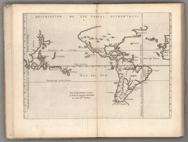
Full Title
Descripcion de las Indias Ocidentalis.
List No
14476.006
Note
Map of the Western Hemisphere, featuring the West Indies. Shows countries, cities, topography, bodies of water, drainage, coastlines and islands. Relief shown pictorially. Includes latitudinal lines and longitudinal lines, as well as a descriptive note. Black and white engraving. Map is 23 x 32 cm, on double sheet 29 x 36 cm. Appears in Descriptio Indiae Occidentalis per Antonium de Herrera regium Indiarum et Castellae historiographum, the first part of Nieuwe werelt anders ghenaempt West-Indien. (Plate number inferred.)
Herrera y Tordesillas, Antonio de, -1625 Descripçion de las Indias del Norte. 1622 14476.007 Related Author
Herrera y Tordesillas, Antonio de, -1625
Full Title
Descripçion de las Indias del Norte.
List No
14476.007
Note
Map of the West Indies. Shows countries, audiencias (royal courts in Spanish colonial America), bodies of water, drainage, coastlines and islands. Includes latitudinal lines and longitudinal lines, as well as descriptive notes. Black and white engraving. Map is 21 x 29 cm, on double sheet 29 x 36 cm. Appears in Descriptio Indiae Occidentalis per Antonium de Herrera regium Indiarum et Castellae historiographum, the first part of Nieuwe werelt anders ghenaempt West-Indien.
Herrera y Tordesillas, Antonio de, -1625 Description del destricto del audiencia ... 1622 14476.008 Related Author
Herrera y Tordesillas, Antonio de, -1625
Full Title
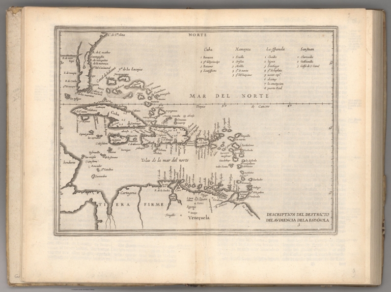
Description del destricto del audiencia de la Española.
List No
14476.008
Note
Map of Hispaniola. Shows countries, regions, cities, bodies of water, drainage, coastlines, shoals and islands. Includes latitudinal lines and longitudinal lines. Indexed to indicate city names. Black and white engraving. Map is 21 x 29 cm, on double sheet 29 x 36 cm. Appears in Descriptio Indiae Occidentalis per Antonium de Herrera regium Indiarum et Castellae historiographum, the first part of Nieuwe werelt anders ghenaempt West-Indien.
Herrera y Tordesillas, Antonio de, -1625 Descripçion del destricto del audiencia ... 1622 14476.009 Related Author
Herrera y Tordesillas, Antonio de, -1625
Full Title
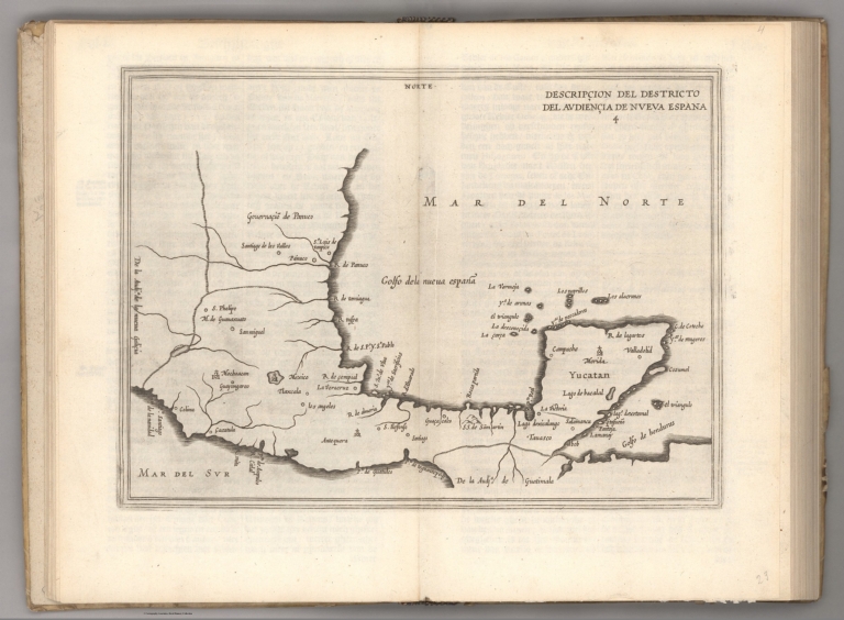
Descripçion del destricto del audiencia de Nueva Espana.
List No
14476.009
Note
Map of Nueva Espana [New Spain] (current-day southern Mexico). Shows regions, cities, topography, bodies of water, drainage, coastlines and islands. Relief shown pictorially. Includes a descriptive note. Black and white engraving. Map is 21 x 29 cm, on double sheet 29 x 36 cm. Appears in Descriptio Indiae Occidentalis per Antonium de Herrera regium Indiarum et Castellae historiographum, the first part of Nieuwe werelt anders ghenaempt West-Indien.
Herrera y Tordesillas, Antonio de, -1625 Descripcion del destricto del audiencia ... 1622 14476.010 Related Author
Herrera y Tordesillas, Antonio de, -1625
Full Title
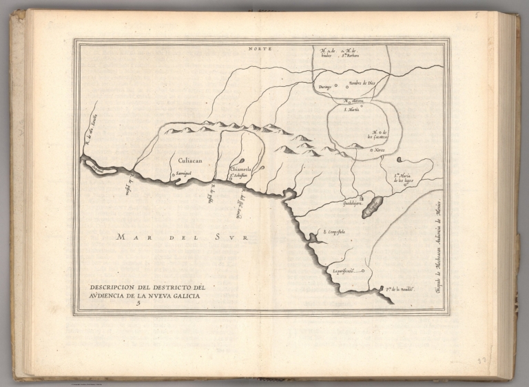
Descripcion del destricto del audiencia de la Nueva Galicia.
List No
14476.010
Note
Map of Nueva Galicia [New Galicia] (current-day southern Mexico). Shows regions, cities, topography, bodies of water, drainage, coastlines and islands. Relief shown pictorially. Includes a descriptive note. Black and white engraving. Map is 21 x 29 cm, on double sheet 29 x 36 cm. Appears in Descriptio Indiae Occidentalis per Antonium de Herrera regium Indiarum et Castellae historiographum, the first part of Nieuwe werelt anders ghenaempt West-Indien.
Herrera y Tordesillas, Antonio de, -1625 Descripcion del audiencia de Guatimala. 1622 14476.011 Related Author
Herrera y Tordesillas, Antonio de, -1625
Full Title
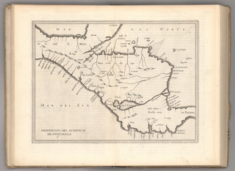
Descripcion del audiencia de Guatimala.
List No
14476.011
Note
Map of Guatemala. Shows countries, regions, cities, topography, bodies of water, drainage, coastlines, shoals and islands. Relief shown pictorially. Black and white engraving. Map is 21 x 29 cm, on double sheet 29 x 36 cm. Appears in Descriptio Indiae Occidentalis per Antonium de Herrera regium Indiarum et Castellae historiographum, the first part of Nieuwe werelt anders ghenaempt West-Indien.
Herrera y Tordesillas, Antonio de, -1625 Descripcion de las Indias de Mediodia. 1622 14476.012 Related Author
Herrera y Tordesillas, Antonio de, -1625
Full Title
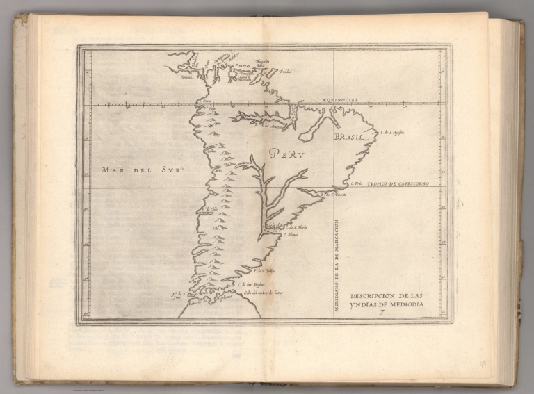
Descripcion de las Indias de Mediodia.
List No
14476.012
Note
Map of South America. Shows countries, regions, topography, bodies of water, drainage, coastlines, shoals and islands. Relief shown pictorially. Includes latitudinal and longitudinal lines. Black and white engraving. Map is 21 x 29 cm, on double sheet 29 x 36 cm. Appears in Descriptio Indiae Occidentalis per Antonium de Herrera regium Indiarum et Castellae historiographum, the first part of Nieuwe werelt anders ghenaempt West-Indien.
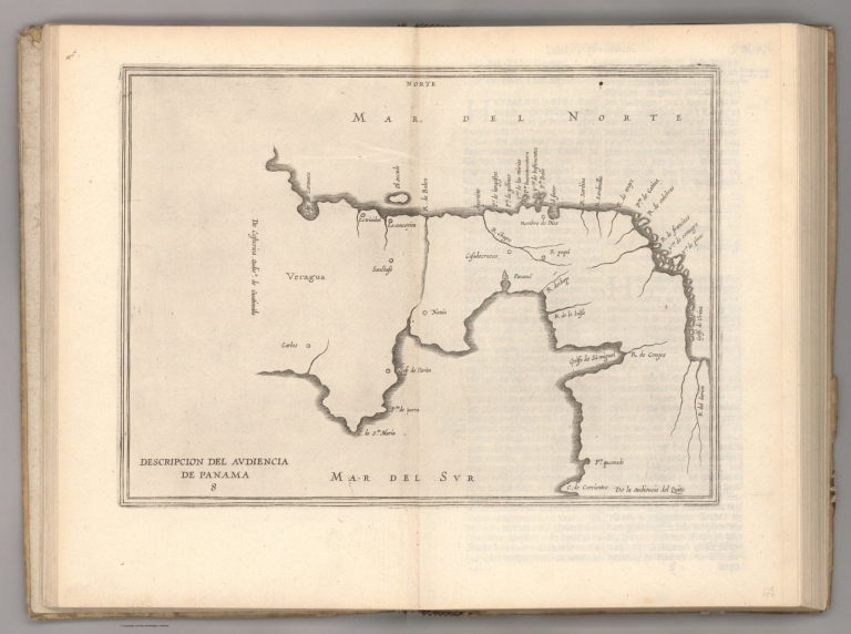
Herrera y Tordesillas, Antonio de, -1625 Descripcion del audiencia de Panama. 1622 14476.013 Related Author
Herrera y Tordesillas, Antonio de, -1625
Full Title
Descripcion del audiencia de Panama.
List No
14476.013
Note
Map of Panama. Shows regions, cities, bodies of water, drainage, coastlines and islands. Includes descriptive notes. Black and white engraving. Map is 21 x 29 cm, on double sheet 29 x 36 cm. Appears in Descriptio Indiae Occidentalis per Antonium de Herrera regium Indiarum et Castellae historiographum, the first part of Nieuwe werelt anders ghenaempt West-Indien.
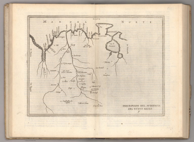
Herrera y Tordesillas, Antonio de, -1625 Descripcion del audiencia del Nuevo Rein... 1622 14476.014 Related Author
Herrera y Tordesillas, Antonio de, -1625
Full Title
Descripcion del audiencia del Nuevo Reino.
List No
14476.014
Note
Map of Nuevo Reino ["New Kingdom"] (current-day northwestern Venezuela). Shows regions, cities, bodies of water, drainage, coastline and islands. Includes descriptive notes. Black and white engraving. Map is 21 x 29 cm, on double sheet 29 x 36 cm. Appears in Descriptio Indiae Occidentalis per Antonium de Herrera regium Indiarum et Castellae historiographum, the first part of Nieuwe werelt anders ghenaempt West-Indien.
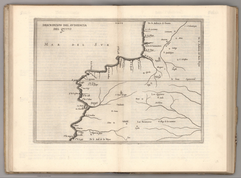
Herrera y Tordesillas, Antonio de, -1625 Descripcion del audiencia del Quito. 1622 14476.015 Related Author
Herrera y Tordesillas, Antonio de, -1625
Full Title
Descripcion del audiencia del Quito.
List No
14476.015
Note
Map of Quito and vicinity, Ecuador. Shows regions, topography, cities, bodies of water, drainage, coastline and islands. Relief shown pictorially. Includes descriptive notes. Black and white engraving. Map is 21 x 29 cm, on double sheet 29 x 36 cm. Appears in Descriptio Indiae Occidentalis per Antonium de Herrera regium Indiarum et Castellae historiographum, the first part of Nieuwe werelt anders ghenaempt West-Indien.
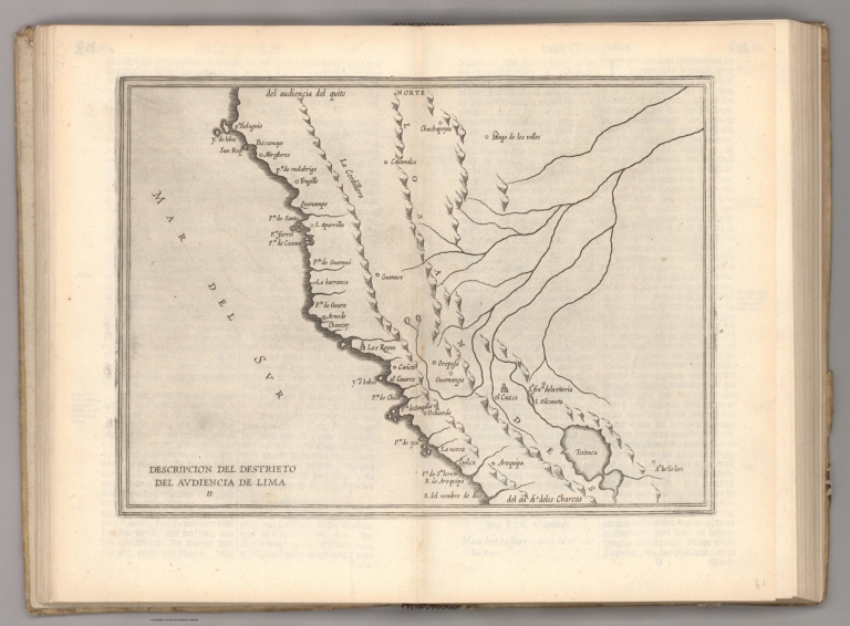
Herrera y Tordesillas, Antonio de, -1625 Descripcion del destrieto del audiencia ... 1622 14476.016 Related Author
Herrera y Tordesillas, Antonio de, -1625
Full Title
Descripcion del destrieto del audiencia de Lima.
List No
14476.016
Note
Map of Lima and vicinity, Peru. Shows regions, cities, topography, bodies of water, drainage, coastline and islands. Relief shown pictorially. Includes descriptive notes. Black and white engraving. Map is 21 x 29 cm, on double sheet 29 x 36 cm. Appears in Descriptio Indiae Occidentalis per Antonium de Herrera regium Indiarum et Castellae historiographum, the first part of Nieuwe werelt anders ghenaempt West-Indien.
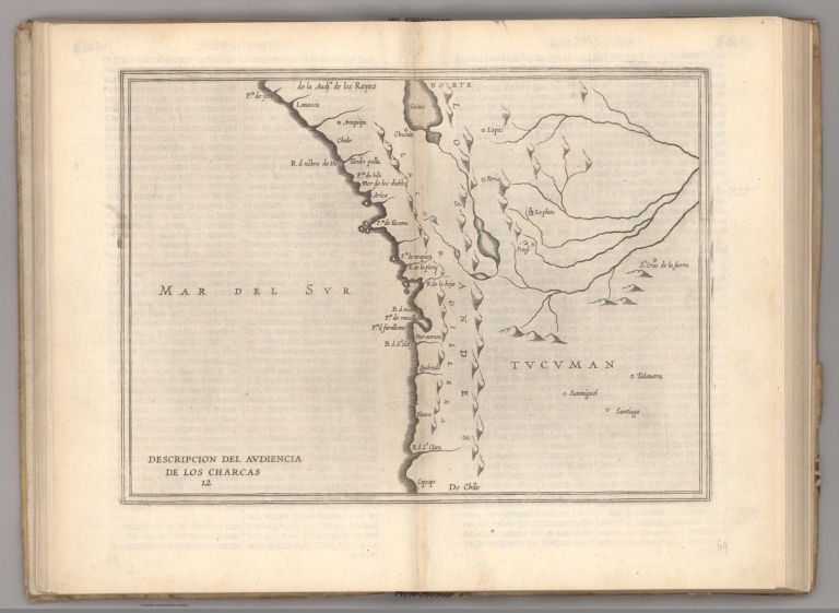
Herrera y Tordesillas, Antonio de, -1625 Descripcion del audiencia de los Charcas... 1622 14476.017 Related Author
Herrera y Tordesillas, Antonio de, -1625
Full Title
Descripcion del audiencia de los Charcas.
List No
14476.017
Note
Map of Charcas (current-day Bolivia). Shows regions, cities, topography, bodies of water, drainage, coastline and islands. Relief shown pictorially. Includes descriptive notes. Black and white engraving. Map is 21 x 29 cm, on double sheet 29 x 36 cm. Appears in Descriptio Indiae Occidentalis per Antonium de Herrera regium Indiarum et Castellae historiographum, the first part of Nieuwe werelt anders ghenaempt West-Indien.
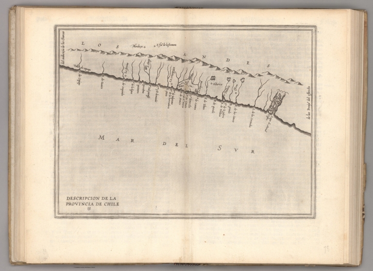
Herrera y Tordesillas, Antonio de, -1625 Descripcion de la Provincia de Chile. 1622 14476.018 Related Author
Herrera y Tordesillas, Antonio de, -1625
Full Title
Descripcion de la Provincia de Chile.
List No
14476.018
Note
Map of Chile. Shows cities, topography, bodies of water, drainage, coastline and islands. Relief shown pictorially. Includes descriptive notes. Black and white engraving. Map is 21 x 29 cm, on double sheet 29 x 36 cm. Appears in Descriptio Indiae Occidentalis per Antonium de Herrera regium Indiarum et Castellae historiographum, the first part of Nieuwe werelt anders ghenaempt West-Indien.
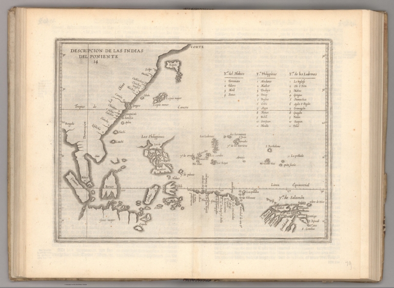
Author
Herrera y Tordesillas, Antonio de, -1625
Full Title
Descripcion de las del Poniente.
List No
14476.019
Note
Map of areas including the East Indies, Papua New Guinea and the Solomon Islands. Shows countries, cities, bodies of water, drainage, coastlines and islands. Includes latitudinal and longitudinal lines. Indexed to indicate city names. Black and white engraving. Map is 21 x 29 cm, on double sheet 29 x 36 cm. Appears in Descriptio Indiae Occidentalis per Antonium de Herrera regium Indiarum et Castellae historiographum, the first part of Nieuwe werelt anders ghenaempt West-Indien.
Author
Le Maire, Jacques, 1585-1616
Full Title
[Tierra del Fuogo].
List No
14476.024
Note
Map of Tierra del Fuego, an archipelago at South America’s southernmost tip, shared by current-day Chile and Argentina. Shows regions, bodies of water, drainage, coastlines and islands. Features voyages routes. Includes rhumb lines, latitudinal lines and a compass rose with north oriented toward top of sheet. With descriptive notes in cartouche. Black and white engraving. Map is 20 x 28 cm, on double sheet 29 x 36 cm. Appears in Spieghel der Australische navigatie, the third part of Nieuwe werelt anders ghenaempt West-Indien.
Author
Le Maire, Jacques, 1585-1616
Full Title
[Pacific Ocean].
List No
14476.029
Note
Map of the Pacific Ocean, including the west coast of South America. Shows cities, bodies of water, drainage, coastlines and islands. Features voyages routes. Includes rhumb lines, latitudinal and longitudinal lines, as well as compass roses with north oriented toward top of sheet. With descriptive notes in cartouche. Black and white engraving. Map is 22 x 53 cm, on fold-out sheet 29 x 56 cm. Appears in Spieghel der Australische navigatie, the third part of Nieuwe werelt anders ghenaempt West-Indien.
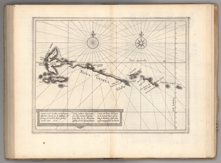
Author
Le Maire, Jacques, 1585-1616
Full Title
Nova Guinea.
List No
14476.030
Note
Map of Papua New Guinea. Shows cities, bodies of water, drainage, coastlines and islands. Features voyages routes. Includes rhumb lines, latitudinal and longitudinal lines, as well as compass roses with north oriented toward top of sheet. With descriptive notes in cartouche. Black and white engraving. Map is 20 x 28 cm, on double sheet 29 x 36 cm. Appears in Spieghel der Australische navigatie, the third part of Nieuwe werelt anders ghenaempt West-Indien.
La Condamine, Charles-Marie de, 1701-177... Carte de la province de Quito au Perou .... 1751 14377.003 Related Author
[La Condamine, Charles-Marie de, 1701-1774, Maldonado, Pedro]
Full Title
Carte de la province de Quito au Perou dressée sur les observations astronomiques, mesures géographiques, journaux de route et mémoires de Mr. de la Condamine, et fur ceux de Don Pedro Maldonado. Par Mr. d'Anville de l'Acad. Imperiale de Petersbourg. 1751.
List No
14377.003
Note
Map of Quito in Peru, based upon the astronomical observations, geographical measurements, travel journals and memoirs of Mr. de la Condamine and Don Pedro Maldonado. Shows routes, topography, volcanos, vegetation, drainage, coastline, islands and shoals. Relief shown pictorially. Includes latitudinal and longitudinal lines, as well as explanatory notes and eight bar scales. Map indexed to indicate place names. With decorative cartouches. Black and white engraving. Map is 59 x 34 cm, on fold-out sheet 62 x 38 cm.
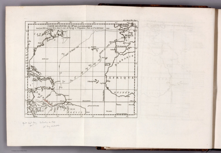
La Condamine, Charles-Marie de, 1701-177... Carte des routes de Mr. de la Condamine ... 1751 14377.006 Related Author
La Condamine, Charles-Marie de, 1701-1774
Full Title
Carte des routes de Mr. de la Condamine tant par Mer que par Terre dans le cours du Voyage à l'Equateur : Par le Sr. d'Anville. Gravé par G. Delahaye.
List No
14377.006
Note
Map of the Atlantic Ocean showing Condamine's routes both by sea and land during the Voyage to the Equator. Shows routes, topography, drainage, coastlines, islands and shoals. Relief shown pictorially. Includes latitudinal and longitudinal lines, as well as explanatory notes. Black and white engraving. Map is 17 x 20 cm, on fold-out sheet 25 x 40 cm. With handwritten annotations in pencil at bottom margin. Appears in first part of volume.
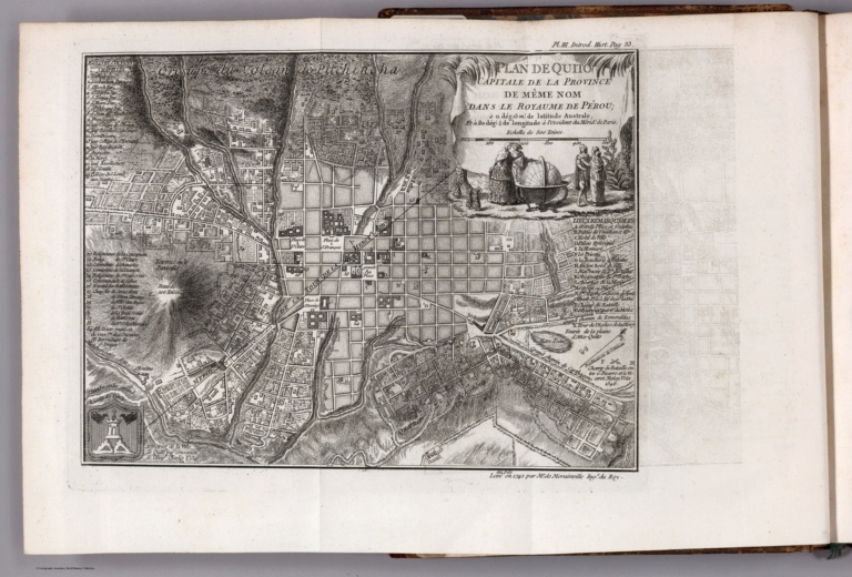
La Condamine, Charles-Marie de, 1701-177... Plan de Quito, capitale de la province d... 1741 14377.009 Related Author
La Condamine, Charles-Marie de, 1701-1774
Full Title
Plan de Quito, capitale de la province de même nom dans le royaume de Pérou ... au pas leve en 1741 par Mr. de Morainville Ingr. du Roy.
List No
14377.009
Note
Map of Quito. Shows buildings, roads, topography, vegetation and drainage. Relief shown with hachures. Includes explanatory notes. Indexed to indicate place names. With vignette featuring figures around a globe. Black and white engraving. Map is 21 x 26 cm, on fold-out sheet 26 x 40 cm. Appears in first part of volume.
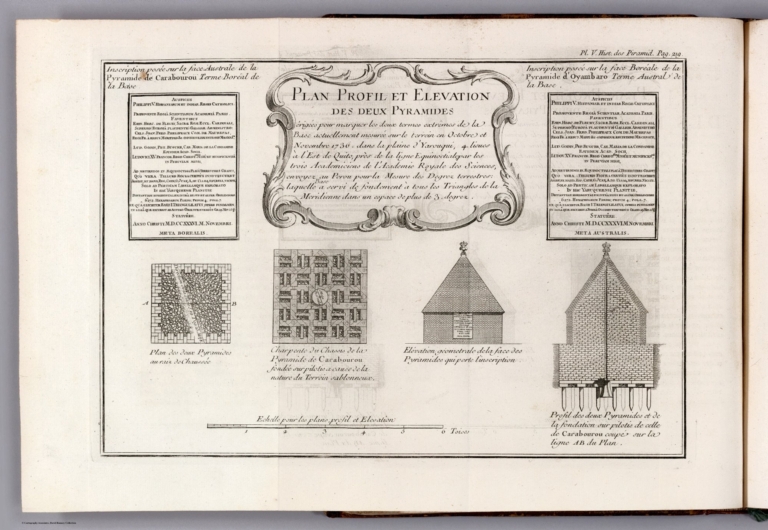
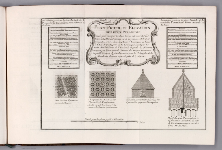
La Condamine, Charles-Marie de, 1701-177... Plan profil et elevation des deux pyrami... 1751 14377.012 Related Author
La Condamine, Charles-Marie de, 1701-1774
Full Title
Plan profil et elevation des deux pyramides. (1)
List No
14377.012
Note
Maps of two pyramids, as well as profile views. Shows architecture, including elevation of buildings. Includes a bar scale and explanatory notes. With decorative cartouche. Black and white engraving. Together, maps and views are 20 x 26 cm, on fold-out sheet 26 x 40 cm. Maps and views appear in first part of volume.
La Condamine, Charles-Marie de, 1701-177... Plan profil et elevation des deux pyrami... 1751 14377.014 Related Author
La Condamine, Charles-Marie de, 1701-1774
Full Title
Plan profil et elevation des deux pyramides. (2)
List No
14377.014
Note
Maps of two pyramids, as well as profile views. Shows architecture, including elevation of buildings. Includes a bar scale and explanatory notes. With decorative cartouche. Black and white engraving. Together, maps and views are 20 x 30 cm, on fold-out sheet 26 x 40 cm. Maps and views appear in second part of volume.
Ulloa, Antonio de, 1716-1795; Juan, Jorg... Plano de la Ciudad de Cartagena de las I... 1735 14378.023 Related Author
[Ulloa, Antonio de, 1716-1795, Juan, Jorge, 1713-1773]
Full Title
Plano de la Ciudad de Cartagena de las Indias ... Levantado por orden del Rey Nro. Sr. ano de 1735. Cs. Bargas delt. Cs. Casanova ext.
List No
14378.023
Note
Map featuring Cartagena, Colombia. Shows city blocks, streets, bridges, topography, vegetation, bodies of water, drainage, coastline and islands. Relief shown pictorially. Includes two bar scales and a compass rose with north oriented toward bottom left side of sheet. Indexed to indicate place names. With decorative cartouches. Black and white engraving. Map is 25 x 38 cm, on fold-out sheet 37 x 44 cm. Appears in the first volume of Relacion historica del viage hecho de orden de S. Mag. a la America Meridional.
Ulloa, Antonio de, 1716-1795; Juan, Jorg... Plano de la Bahia de Cartagena de la Ind... 1735 14378.024 Related Author
[Ulloa, Antonio de, 1716-1795, Juan, Jorge, 1713-1773]
Full Title
Plano de la Bahia de Cartagena de la Indias ... Levantado por orden del Rey Nro. Sr. ano de 1735. Cs. Bargas dt. Cva sculpt.
List No
14378.024
Note
Map featuring Cartagena Bay, Colombia. Shows settlements, roads, topography, vegetation, bodies of water, drainage, coastline, islands, shoals and depths. Relief shown pictorially. Includes two bar scales and a compass rose with north oriented toward left side of sheet. With decorative cartouche. Black and white engraving. Map is 26 x 38 cm, on fold-out sheet 37 x 44 cm. Appears in the first volume of Relacion historica del viage hecho de orden de S. Mag. a la America Meridional.
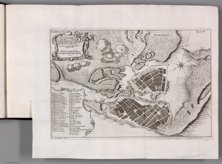
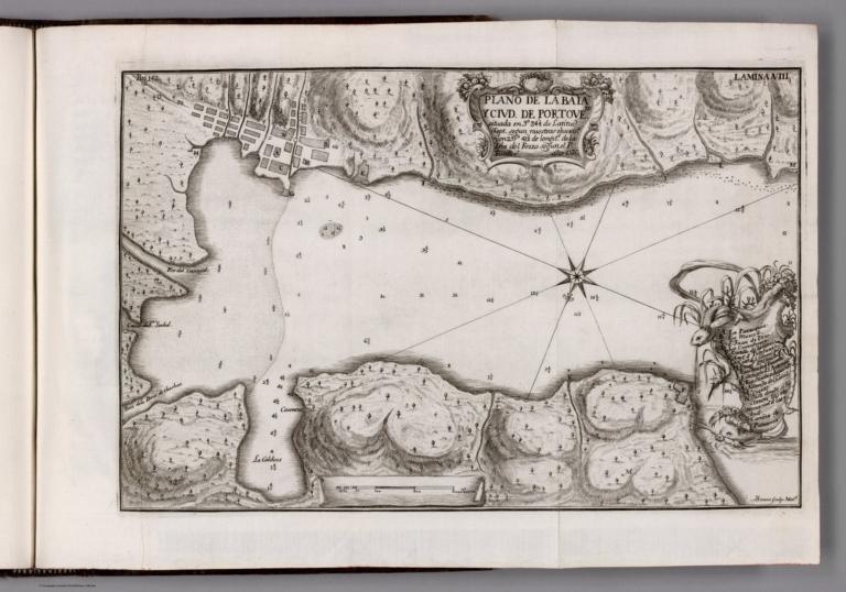
Ulloa, Antonio de, 1716-1795; Juan, Jorg... Plano de la Bhia y Ciud. de Portovelo ..... 1736 14378.026 Related Author
[Ulloa, Antonio de, 1716-1795, Juan, Jorge, 1713-1773]
Full Title
Plano de la Bhia y Ciud. de Portovelo ... ano de 1736. Mozeno sculp. Math.
List No
14378.026
Note
Map featuring the city of Portobelo and Portobelo Bay, Panama. Shows city blocks, streets, topography, vegetation, drainage, coastline, islands, shoals and depths. Relief shown pictorially. Includes a bar scale and a compass rose with north oriented toward lower left side of sheet. Indexed to indicate place names. With decorative cartouches. Black and white engraving. Map is 22 x 34 cm, on fold-out sheet 27 x 39 cm. Appears in the first volume of Relacion historica del viage hecho de orden de S. Mag. a la America Meridional.
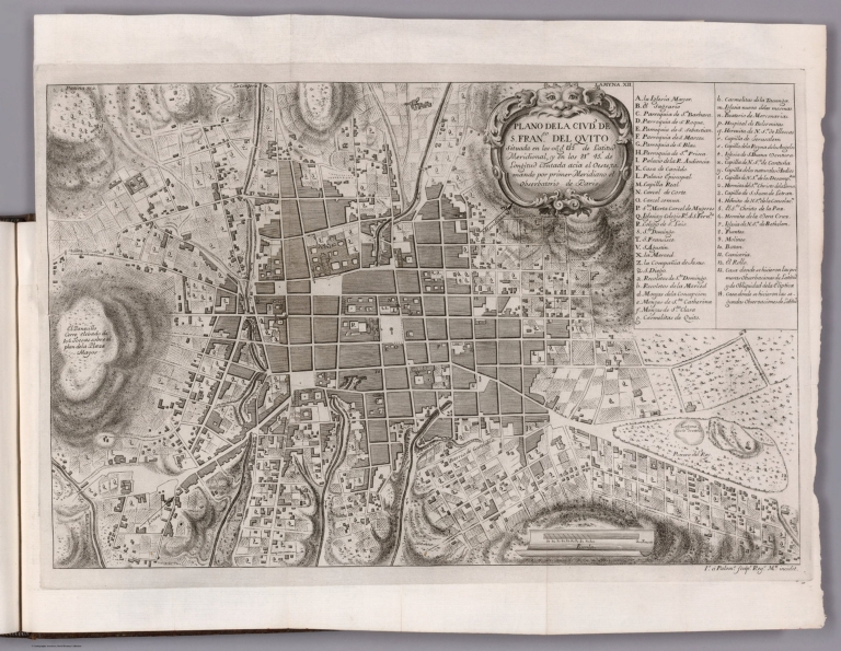
Ulloa, Antonio de, 1716-1795; Juan, Jorg... Plano de la Ciudd. de S. Franco. del Qui... 1748 14378.033 Related Author
[Ulloa, Antonio de, 1716-1795, Juan, Jorge, 1713-1773]
Full Title
Plano de la Ciudd. de S. Franco. del Quito ... Is. á Palomo sculpr. Regs. Mri. incidit.
List No
14378.033
Note
Map featuring the city of Quito, Ecuador. Shows city blocks, streets, topography, vegetation and drainage. Relief shown pictorially. Includes explanatory notes, as well as a bar scale and compass rose with north oriented toward upper right side of sheet Indexed to indicate place names. With decorative cartouche. Black and white engraving. Map is 31 x 49 cm, on fold-out sheet 40 x 53 cm. Appears in the first volume of Relacion historica del viage hecho de orden de S. Mag. a la America Meridional.
Ulloa, Antonio de, 1716-1795; Juan, Jorg... Carta de la Meridiana medida en el Reyno... 1744 14378.045 Related Author
[Ulloa, Antonio de, 1716-1795, Juan, Jorge, 1713-1773]
Full Title
Carta de la Meridiana medida en el Reyno de Quito ... Don Jorge Juan, y Dn. Antonío de Ulloa : concluida año de 1744. Is. á Palomo. sculpr. Regs. Mti. incidit.
List No
14378.045
Note
Map featuring the meridian measured in the Kingdom of Quito by the Order of the King in 1744. Shows settlements, topography, vegetation, drainage and lines of measurement. Relief shown pictorially. Includes a key and bar scale. With decorative cartouche. Black and white engraving. Map is 23 x 101 cm, on fold-out sheet 27 x 126 cm. Appears in the second volume of Relacion historica del viage hecho de orden de S. Mag. a la America Meridional.
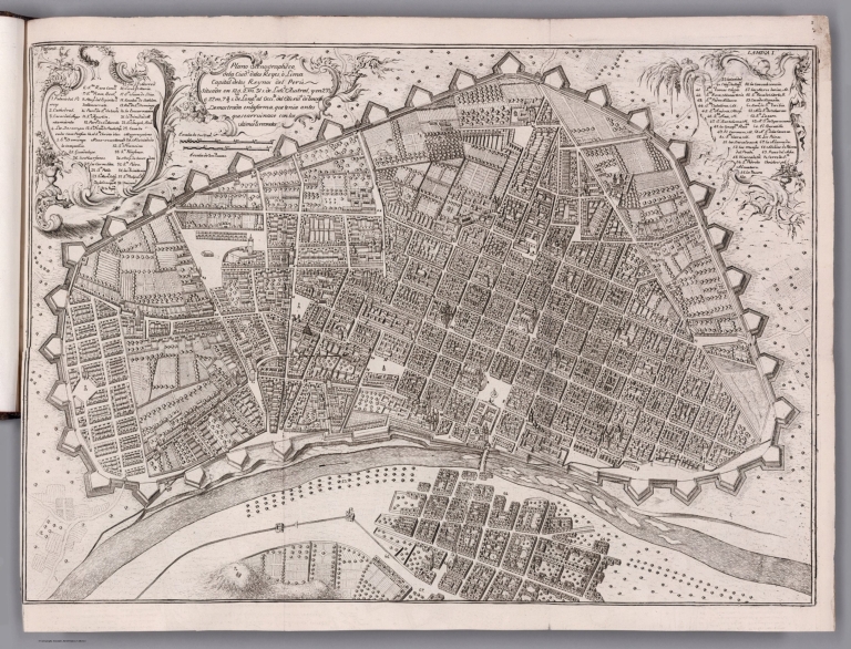
Ulloa, Antonio de, 1716-1795; Juan, Jorg... Plano scenographico, de la Ciudo. de las... 1748 14378.056 Related Author
[Ulloa, Antonio de, 1716-1795, Juan, Jorge, 1713-1773]
Full Title
Plano scenographico, de la Ciudo. de las Reyes ò Lima Capital de los Reynos del Perú ...
List No
14378.056
Note
Map featuring Lima, Peru. Formatted as a bird's-eye-view. Shows city blocks, streets, bridges, fortification, topography, vegetation and drainage. Relief shown pictorially. Includes two bar scales, as well as an arrow pointing out the water direction in the river. Indexed to indicate place names, with key at upper left and right. With decorative cartouches. Black and white engraving. Map is 38 x 54 cm, on fold-out sheet 42 x 56 cm. Appears in the third volume of Relacion historica del viage hecho de orden de S. Mag. a la America Meridional.
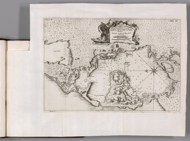
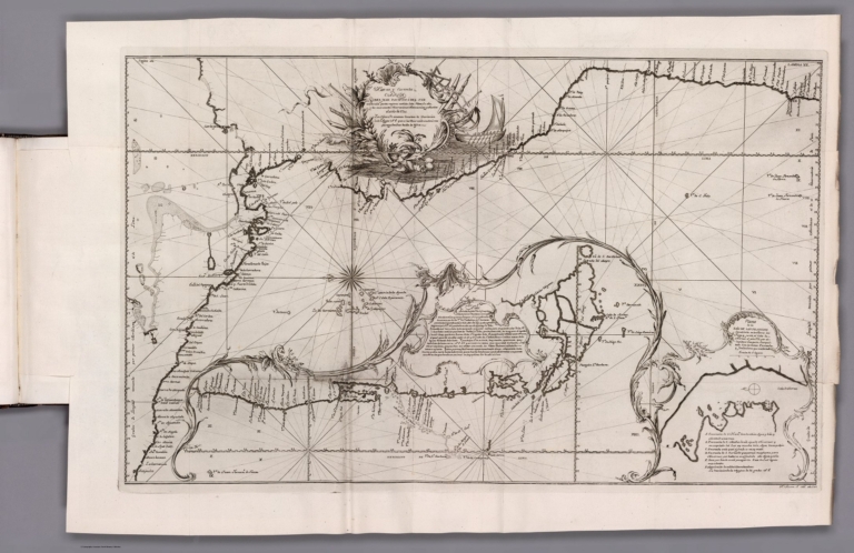
Ulloa, Antonio de, 1716-1795; Juan, Jorg... Nueva y correcta carta del Mar Pacifico ... 1744 14378.072 Related Author
[Ulloa, Antonio de, 1716-1795, Juan, Jorge, 1713-1773]
Full Title
Nueva y correcta carta del Mar Pacifico ó del Sur ... el año de 1744. Fuente F. M.
List No
14378.072
Note
Map featuring the South Pacific Ocean. Shows ports, drainage, coastline, islands, shoals, depths and anchorage. Includes explanatory notes, latitudinal and longitudinal lines, as well as a bar scale and compass rose with north oriented toward left side of sheet. Indexed to indicate place names, with key at bottom right. With decorative cartouches. Black and white engraving. Map is 43 x 71 cm, on fold-out sheet 52 x 79 cm. Appears in the fourth volume of Relacion historica del viage hecho de orden de S. Mag. a la America Meridional.
Author
Azara, Felix de
Full Title
Carte generale du Paraguay et de la province de Buenos-Ayres. (to accompany) Voyages dans l'Amerique meridonale, par Don Felix de Azara.1809.
List No
13381.007
Note
Engrave folded outline hand color map. Shows major rivers colored in orange and yellow. Relief shown pictorially. Prime meridian: Paris.
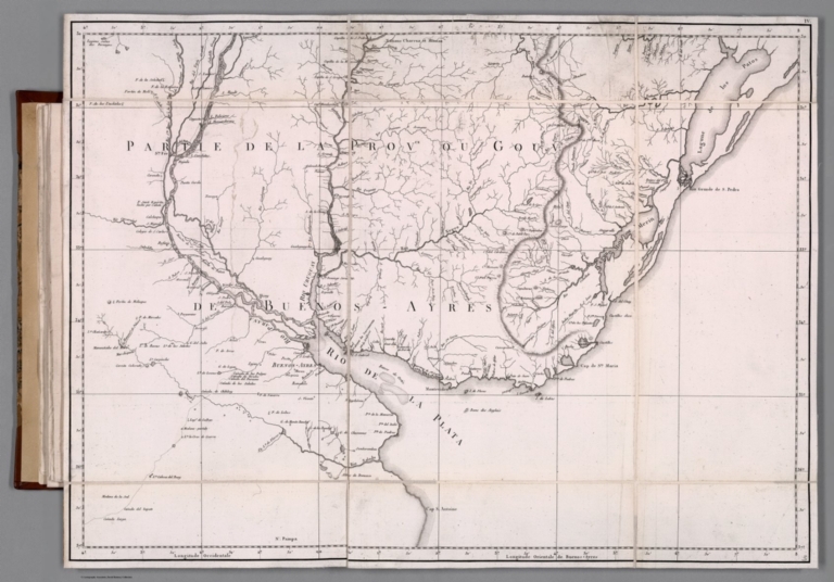
Author
Azara, Felix de
Full Title
Partie de la provce. ou gouvt. de Buenos Ayres. (to accompany) Voyages dans l'Amerique meridonale, par Don Felix de Azara.1809.
List No
13381.008
Note
Engrave folded map. Shows major rivers, cities and towns. Relief shown pictorially. Prime meridians: Paris.
Author
Azara, Felix de
Full Title
Gouvt. du Paraguay. (to accompany) Voyages dans l'Amerique meridonale, par Don Felix de Azara.1809.
List No
13381.009
Note
Engrave folded map. Title from table of contents. Shows major rivers, cities and towns. Relief shown pictorially. Includes notes.
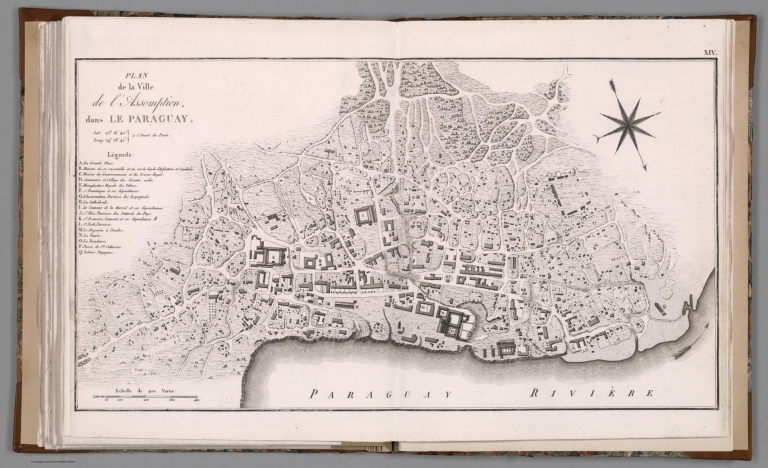
Author
Azara, Felix de
Full Title
Plan de la ville de l'Assomption dans le Paraguay. (to accompany) Voyages dans l'Amerique meridonale, par Don Felix de Azara. 1809.
List No
13381.018
Note
Engraved plan. Shows buildings, roads, rivers, canals and landmarks. Compass rose oriented with north to the lower right. Includes legend.
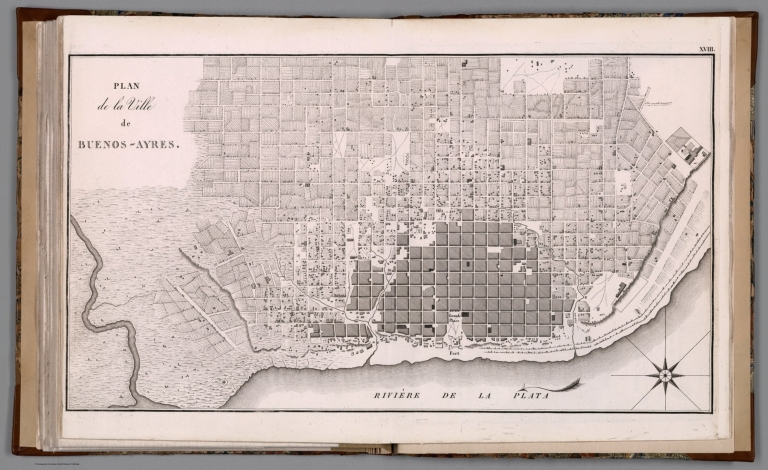
Author
Azara, Felix de
Full Title
Plan de la Ville de Buenos - Ayres. (to accompany) Voyages dans l'Amerique meridonale, par Don Felix de Azara. 1809.
List No
13381.022
Note
Engraved plan of the city of Buenos Aires. Shows streets, city blocks, buildings, forts, farmlands, and waterways. Relief shown by hachures.
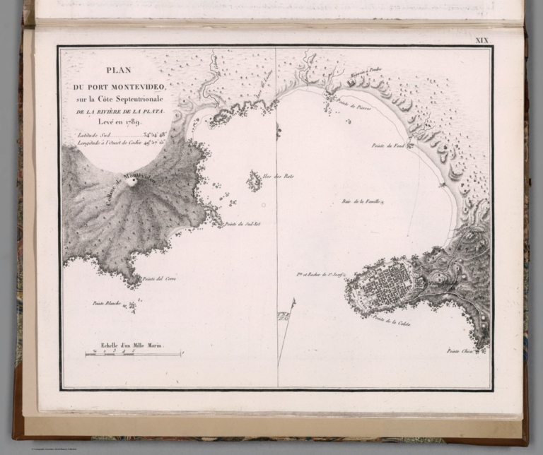
Author
Azara, Felix de
Full Title
Plan du Port Montevideo sur la Cote septentrionale de la riviere de la Plata. Leve en 1789. (to accompany) Voyages dans l'Amerique meridonale, par Don Felix de Azara. 1809.
List No
13381.023
Note
Engraved map of Port Montevideo on the northern coast of the Plata river. Relief shown by hachures. Scale 2 1/3 inches to a sea mile.
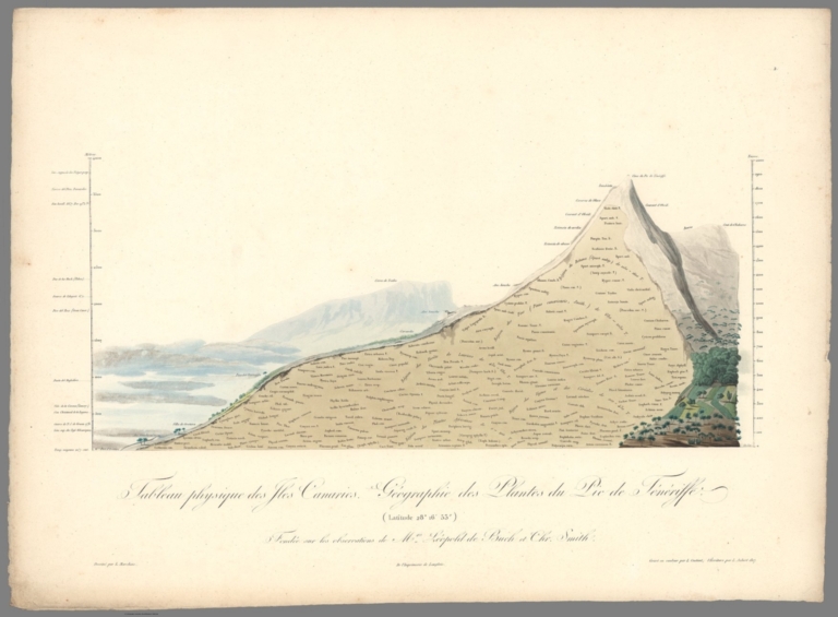
Humboldt, Alexander von, 1769-1859; Bonp... II. Tableau physique des iles Canaries. ... 1817 12125.024 Related Author
[Humboldt, Alexander von, 1769-1859, Bonpland, Aime, Marchais, L., de Buch, Leopold, Smith, Chr.]
Full Title
II. Tableau physique des iles Canaries. Geographie des plantes du Pic de Teneriffe.
List No
12125.024
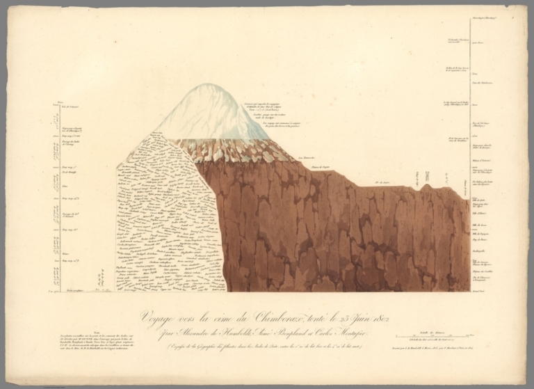
Humboldt, Alexander von, 1769-1859; Bonp... IX. Voyage vers la cime du Chimborazo, t... 1824 12125.031 Related Author
[Humboldt, Alexander von, 1769-1859, Bonpland, Aime, Marchais, F., Kunth, Montufar, Carlos]
Full Title
IX. Voyage vers la cime du Chimborazo, tenete le 24 juin 1802. Geographie des plantes dans les Andes de Quito.
List No
12125.031
Author
[Humboldt, Alexander von, 1769-1859, Bonpland, Aime]
Full Title
XXIX. Plan du volcan de Jorullo.
List No
12125.051
Humboldt, Alexander von, 1769-1859; Bonp... XXXIII. Le Nouveau Continent Figure dans... 1834 12125.055 Related Author
[Humboldt, Alexander von, 1769-1859, Bonpland, Aime, Michaelis, H.]
Full Title
XXXIII. Le Nouveau Continent Figure dans la Mappemonde de Juan de la Cosa en 1500.
List No
12125.055
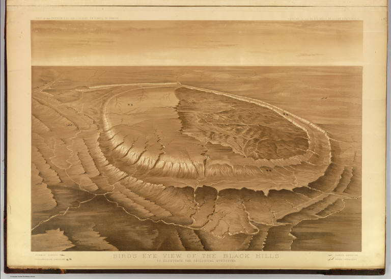
Geographical and Geological Survey of th... Bird's eye view of the Black Hills to il... 1879 2083.001 Related Author
[Geographical and Geological Survey of the Rocky Mountain Region (U.S.), Jenney, Walter Proctor, 1849-1921, Newton, Henry, 1845-1877]
Full Title
Bird's eye view of the Black Hills to illustrate the geological structure. Dept. of the Interior, U.S.G. and G. Survey, J.W. Powell, in charge. Geology of the Black Hills by Henry Newton, E.M. (Julius Bien, Lith. New York, 1879)
List No
2083.001
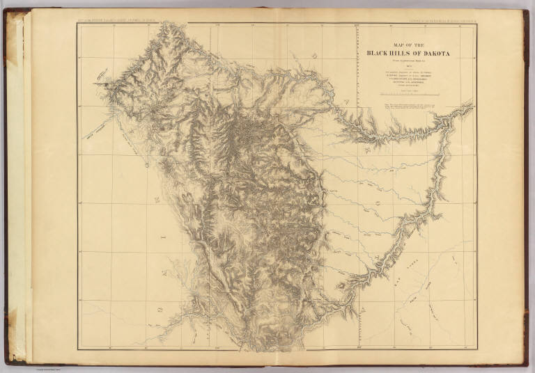
Author
[Geographical and Geological Survey of the Rocky Mountain Region (U.S.), Jenney, Walter Proctor, 1849-1921, M'Gillycuddy, V. T., Mahlo, Emil, 1851-1904, Newton, Henry, 1845-1877, Tuttle, H. P.]
Full Title
Map of the Black Hills of Dakota, from explorations made in 1873. W.P. Jenney, Engineer of Mines, in charge. H. Newton, Engineer of Mines, geologist. V.T. M'Gillycuddy, M.D., topographer. H.P. Tuttle, A.M., astronomer. Drawn by Emil Mahlo. Dept. of the Interior, U.S.G. and G. Survey, J.W. Powell, in charge. Geology of the Black Hills by Henry Newton, E.M. (Julius Bien, Lith. New York, 1879)
List No
2083.002
Note
Color lithograph map. Relief shown by hachures. Includes 3-line note on Sioux Reservation.
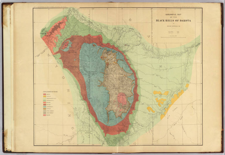
Geographical and Geological Survey of th... Geological map of the Black Hills of Dak... 1879 2083.003 Related Author
[Geographical and Geological Survey of the Rocky Mountain Region (U.S.), Newton, Henry, 1845-1877]
Full Title
Geological map of the Black Hills of Dakota by Henry Newton, E.M. Dept. of the Interior, U.S.G. and G. Survey, J.W. Powell, in charge. Geology of the Black Hills by Henry Newton, E.M. (Julius Bien, Lith. New York, 1879)
List No
2083.003
Note
Color lithograph map. Relief shown by contours, hachures and spot heights.
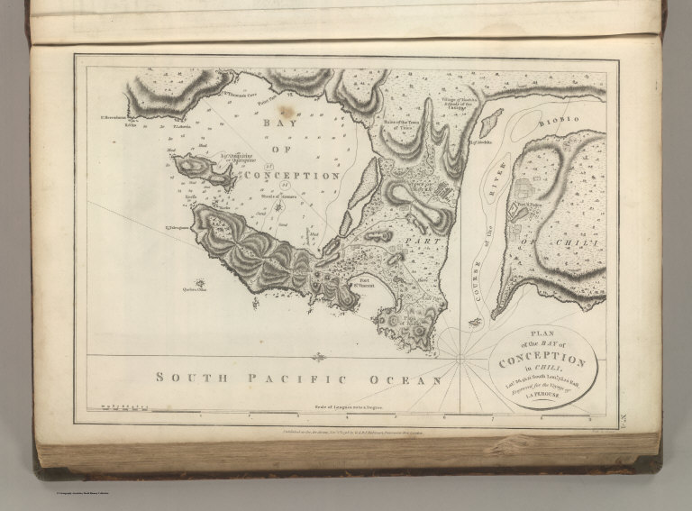
La Perouse, Jean-Francois de Galaup, com... Plan of the Bay of Conception in Chili. 1799 0414.004 Related Author
La Perouse, Jean-Francois de Galaup, comte de, 1741-1788
Full Title
Plan of the Bay of Conception in Chili. .... Engraved for the Voyage of La Perouse. No. 4. Published as the Act directs Novr. 1st 1798, by G.G. & J. Robinson, Paternoster Row. Neele sc. Strand.
List No
0414.004
Note
Engraved. Highly detailed map of Bay of Conception, mouth of the Biobio River, and town of Mocha. Relief shown by hachures. Cultivated areas, buildings, rocks, water depths, fort, swamps, and other features shown.
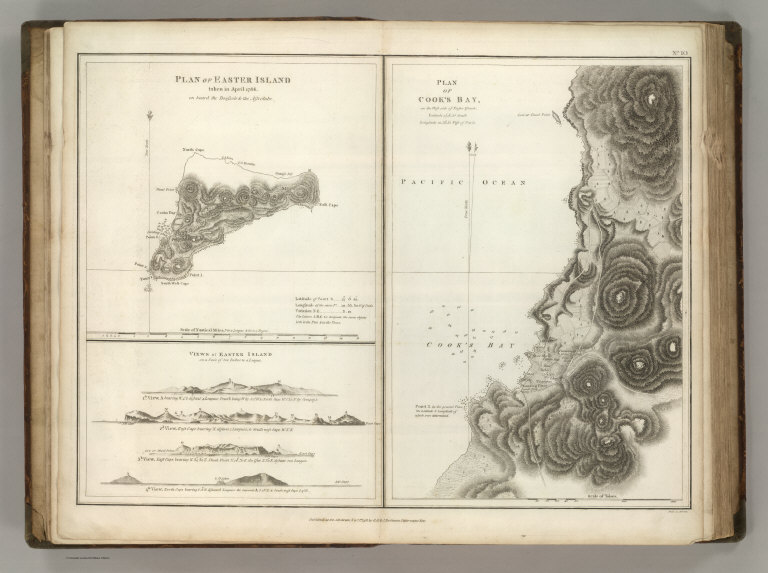
Author
La Perouse, Jean-Francois de Galaup, comte de, 1741-1788
Full Title
(Two maps and one view). Plan of Easter Island, taken in April 1786, on Board the Boussole & the Astrolabe. Views of Easter Island on a Scale of two Inches to a League. Plan of Cook's Bay on the West Side of Easter Island .... Published as the Act directs Novr. 1st 1798, by G.G. & J. Robinson, Pater-noster Row. Heath Sculpt. No. 10.
List No
0414.010
Note
Engraved. Relief shown by hachures. Roads/trails, cultivated areas (paper mulberry), soundings, and rocks shown.
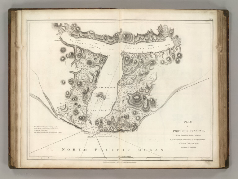
Author
La Perouse, Jean-Francois de Galaup, comte de, 1741-1788
Full Title
Plan of the Port des Francais on the North West Coast of America in 58 degrees 37 minutes Latitude North and 139 degrees 50 minutes of Longitude West, Discovered nd. July 1786, by the Boussole & Astrolabe. Published as the Act directs Novr. 1st 1798, by G.G. & J. Robinson, Paternoster Row, London. Neele, sculpt., 352 Strand. No. 19.
List No
0414.019
Note
Engraved. Relief shown by hachures. Soundings, vegetation, lakes, marshes, and rocks shown. Likely location is Glacier Bay.
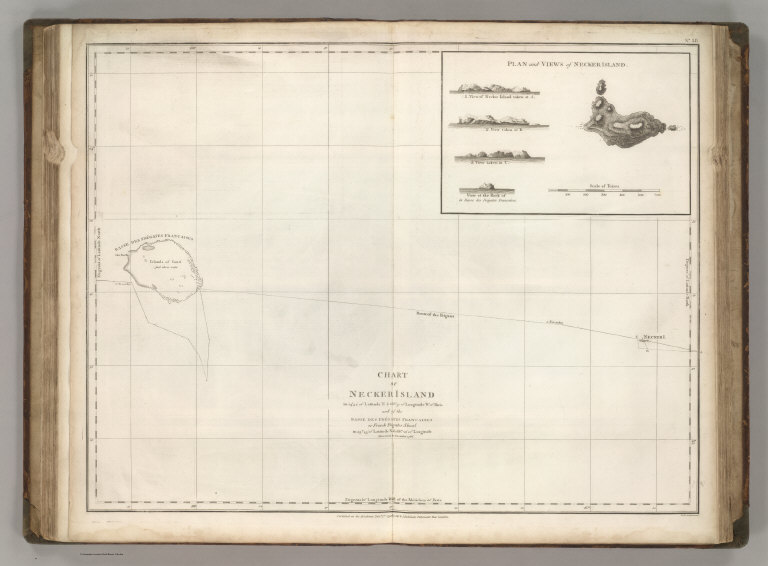
Author
La Perouse, Jean-Francois de Galaup, comte de, 1741-1788
Full Title
Chart of Necker Island in 23 degrees 34 minutes of Latitude N. & 168 degrees 10 minutes Longitude West of Paris and of the Basse des Fregates Francaises of French Frigate Schoal in 23 degrees 45 minutes of Latitude N. & 168 degrees 10 minutes of Longitude, Discovered in Novermber 1786. Published as the Act directs Novr. 1st 1798, by G.G. & J. Robinson, Paternoster Row, London. Neele, sculpt., Strand. No. 38.
List No
0414.038
Note
Engraved. Inset of plan and various views of Necker Island. Meridian Paris.
La Perouse, Jean-Francois de Galaup, com... Discoveries made in 1787 In the Seas of ... 1799 0414.039 Related Author
La Perouse, Jean-Francois de Galaup, comte de, 1741-1788
Full Title
Chart of Discoveries made in 1787 In the Seas of China and Tartary between Manilla and Avateha by the Boussole & Astrolabe. Published as the Act directs Novr. 1st 1798, by G.G. & J. Robinson, Paternoster Row, London. Neele, sculpt., Strand. No. 39.
List No
0414.039
Note
Engraved. Inset of plan and various views of Necker Island. Meridian Paris.
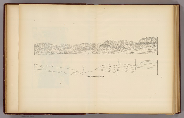
Full Title
The Hurricane Fault. (1895)
List No
0740.039
Note
Uncolored view and cross section.
Full Title
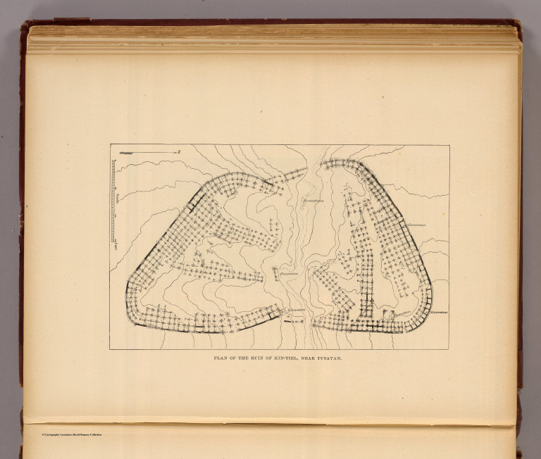
Plan of the ruin of Kin-Tiel, near Tusayan. (1895)
List No
0740.065
Note
Uncolored map. Relief shown by form lines. Oriented with north toward right.
Full Title
Rounded inward curves and projecting cusps of the walls (Grand Canyon, Ariz. 1895)
List No
0740.113
Note
Uncolored map. Relief shown by hachures.
|

![[Tierra del Fuogo].](https://media.davidrumsey.com/MediaManager/srvr?mediafile=/Size3/RUMSEY~8~1/205/14476024.jpg)
![[Pacific Ocean].](https://media.davidrumsey.com/MediaManager/srvr?mediafile=/Size3/RUMSEY~8~1/205/14476029.jpg)