|
Author
Survey of India Department
Full Title
Crops. Sheet 1 : Cotton -- Wheat -- Rice -- Barley. Reg. No. 319, R. & A. Dept. - June 95 - 2,016. Litho., S. I. O., Calcutta.
List No
14252.025
Note
Four lithographed agricultural maps of India, illustrating crops in India, with color coding. Maps show the location of cotton, wheat, rich and barley, and the financial return of each, as well as the boundaries of adjacent countries. Each map includes a legend and explanatory note. First in a series of three maps showing various crops. Together, maps are 26 x 31 cm, on sheet 34 x 43 cm.
Author
Survey of India Department
Full Title
Crops. Sheet 2 : Linseed -- Jowar -- Gingelly -- Bajra. Reg. No. 319, R. & A. Dept. - June 95 - 2,016. Litho., S. I. O., Calcutta.
List No
14252.026
Note
Four lithographed agricultural maps of India, illustrating crops in India, with color coding. Maps show the location of linseed, jowar, gingelly and bajra, and the financial return of each, as well as the boundaries of adjacent countries. Each map includes a legend and explanatory note. Second in a series of three maps showing various crops. Together, maps are 26 x 31 cm, on sheet 34 x 43 cm.
Author
Survey of India Department
Full Title
Crops. Sheet 3 : Tea -- Jute -- Coffee -- Indigo. Reg. No. 319, R. & A. Dept. - June 95 - 2,016. Litho., S. I. O., Calcutta.
List No
14252.027
Note
Four lithographed agricultural maps of India, illustrating crops in India, with color coding. Maps show the location of tea, jute, coffee and indigo, and the financial return of each, as well as the boundaries of adjacent countries. Each map includes a legend and explanatory note. Third in a series of three maps showing various crops. Together, maps are 26 x 31 cm, on sheet 34 x 43 cm.
Author
Survey of India Department
Full Title
Horses and ponies in British India and Mysore. Reg. No. 263, R. & A. Dept. - Dec. 94 - 2,016. Litho., S. I. O., Calcutta.
List No
14252.034
Note
Lithographed biogeography map of India, illustrating horses and ponies, with color coding. Map shows the population of horses and ponies (in thousands), as well as major cities, bays, seas, islands, and the boundaries of adjacent countries. Includes a legend and explanatory note, as well as latitudinal and longitudinal lines, a bar scale and scale statement: Scale 1 inch = 192 miles. With inset map: England and Scotland on the same scale. 26 x 31 cm, on sheet 34 x 43 cm.
Author
Survey of India Department
Full Title
Livestock : Bulls, bullocks, & cows -- Buffaloes -- Sheep & goats -- Uncultivated areas. Reg. No. 271, R. & A. Dept. - Nov. 94 - 2,016. Litho., S. I. O., Calcutta.
List No
14252.035
Note
Four lithographed biogeography maps of India, illustrating livestock, with color coding. Maps show the population of cattle, buffalo, sheep and goats (in thousands), as well as major cities, bays, seas, islands, and the boundaries of adjacent countries. Each map includes a legend and explanatory note. Together, maps are 26 x 31 cm, on sheet 34 x 43 cm.
Author
[Hölzel, Eduard, 1817-1885, Ed. Hölzel (Firm), Toula, Franz, 1845-1920, Chavanne, Josef, 1846-1902, Lorenz von Liburnau, Josef Roman, 1825-1911]
Full Title
Karte des Verhältnisses vom Ackerland zur gesammten productiven Fläche jedes Bezirkes (Comitates) in Oesterreich-Ungarn ausgedrückt in Percenten / von Dr. Jos. R. v. Lorenz -- Karte des Verhältnisses vom Wiesenland zur gesammten productiven Fläche jedes Bezirkes (Comitates) in Oesterreich-Ungarn ausgedrückt in Percenten / von Dr. Jos. R. v. Lorenz -- Karte des Verhältnisses vom Waldland zur gesammten productiven Fläche jedes Bezirkes (Comitates) in Oesterreich-Ungarn ausgedrückt in Percenten / von Dr. Jos. R. v. Lorenz -- Karte des Verhältnisses vom Weinland zur gesammten productiven Fläche jedes Bezirkes (Comitates) in Oesterreich-Ungarn ausgedrückt in Percenten / von Dr. Jos. R. v. Lorenz.
List No
14348.066
Note
Four statistical/physical maps of Austria-Hungary. Maps represent the ratio of arable land, meadows, woods and wine country to the total productive area of each district for Austria-Hungary. Maps show political boundaries, cities, railways, valleys, lakes, drainage, coastlines and islands. Each map includes latitudinal and longitudinal lines, as well as a legend. Colored lithograph. Each map is 21 x 29 cm (together, 45 x 60 cm), on double sheet 49 x 65 cm. Descriptive text for Nr. 22 follows maps.
Author
[Hölzel, Eduard, 1817-1885, Ed. Hölzel (Firm), Toula, Franz, 1845-1920, Chavanne, Josef, 1846-1902, Ritter, Franz, -1932]
Full Title
Die Vertheilung des Grossviehs auf die Fläche in Oesterreich Ungarn nach der Viehzählung vom 31. Dezember 1880 : Vertheilung der Pferde auf die Flächeneinheit (einen Quadrat-Kilometer) -- Vertheilung der Rindvieh's auf die Flächeneinheit (einen Quadrat-Kilometer) -- Vertheilung der Ziegen auf die Flächeneinheit (einen Quadrat-Kilometer) -- Vertheilung der Schafe auf die Flächeneinheit (einen Quadrat-Kilometer) / bearbeitet von Dr. Franz Ritter v. Le Monnier k. k. Ministerial-Vice-Secretär.
List No
14348.070
Note
Four statistical/physical maps of Austria-Hungary. Maps represent the distribution of horses, cattle, goats and sheep for Austria-Hungary. Maps show political boundaries, cities, railways, valleys, lakes, drainage, coastlines and islands. Each map includes latitudinal and longitudinal lines, as well as a legend. Colored lithograph. Each map is 21 x 29 cm (together, 45 x 60 cm), on double sheet 49 x 65 cm. Descriptive text for Nr. 23 follows maps.
Author
[Vincey, Paul, France. Ministere de l'Agriculture]
Full Title
Carte agronomique des environs de Paris. Departement de la Seine. Dressee par order du Ministere de l'Agriculture. et du Prefet. de la Seine ... Par Mr. Paul Vincey. Chromolith. chez L. Wuhrer. Imp. Erhard, Paris. (to accompany) Album de statistique agricole et carte agronomique du departement de la Seine ... par M. Paul Vincey ... 1897. (inset) Profil geologique suivant A.B.
List No
13087.007
Note
Color folded agronomic map. Shows geologic formations, roads, railroads, place names and rivers. Includes descriptive text, charts and legends. Relief shown by contours and spot heights.
Author
[Vincey, Paul, France. Ministere de l'Agriculture]
Full Title
Departement de la Seine : Statistique agricole en 1894 : Repartition des cultures en grandes divisions. Grave chez L. Wuhrer; Ch. Labau del. (to accompany) Album de statistique agricole et carte agronomique du departement de la Seine ... par M. Paul Vincey ... 1897.
List No
13087.008
Note
Color statistical map. Includes descriptive text, statistical tables and key to cultivated area.
Author
[Vincey, Paul, France. Ministere de l'Agriculture]
Full Title
Departement de la Seine : Statistique agricole en 1894 : Redenment du froment par hectare du surface encemencee. Grave chez L. Wuhrer; Ch. Labau del. (to accompany) Album de statistique agricole et carte agronomique du departement de la Seine ... par M. Paul Vincey ... 1897.
List No
13087.012
Note
Color map of France. Includes descriptive text, and color coded key.
Author
[Vincey, Paul, France. Ministere de l'Agriculture]
Full Title
Departement de la Seine : Statistique agricole en 1893 : Repartition des animaix domestiques. Grave chez L. Wuhrer; Ch. Labau del. (to accompany) Album de statistique agricole et carte agronomique du departement de la Seine ... par M. Paul Vincey ... 1897.
List No
13087.018
Note
Color map of France. Includes statistical tables, text, and color coded key.
Author
France. Ministere de l'agriculture
Full Title
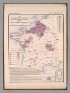
I. Percentage of the various areas making up the total territory of France par department en 1882. Imp. Clerc et Catineau - Paris. (in upper margin) Ministere de l'Agriculture. Album de statistique agricole,1887.
List No
13085.008
Note
Map showing percentage of the various areas making up the total territory of France. Insets: France; Seine; Algerie; Corse. Includes legend and color coded key.
Author
France. Ministere de l'agriculture
Full Title
II. Surface ensemencee en cereales par 100 hectares du territoire total en 1882. E' carts des moyennes departmentales par rapport a la moyenne generale. Imp. Clerc et Catineau - Paris. (in upper margin) Ministere de l'Agriculture. Album de statistique agricole,1887.
List No
13085.009
Note
Map showing of grain planting areas per 100 hactares of the total territory in 1882 and the departmental average in relation to the general average. Insets: Algerie; Corse. Includes legend and color coded key.
Author
France. Ministere de l'agriculture
Full Title
III. Surface ensemencee en cereales par 100 habitants de la population total en 1882. E' carts des moyennes departmentales par rapport a la moyenne generale. Imp. Clerc et Catineau - Paris. (in upper margin) Ministere de l'Agriculture. Album de statistique agricole,1887.
List No
13085.010
Note
Map showing of grain planting areas per 100 inhabitants of the total population in 1882, and the departmental average in relation to the general average. Insets: Algerie; Corse. Includes legend and color coded key.
Author
France. Ministere de l'agriculture
Full Title
IV. Surface ensemencee en froment par 100 hectares du territoire total en 1882. E' carts des moyennes departmentales par rapport a la moyenne generale. Imp. Clerc et Catineau - Paris. (in upper margin) Ministere de l'Agriculture. Album de statistique agricole,1887.
List No
13085.011
Note
Map showing of wheat planting areas per 100 hactares of the total territory in 1882, and the departmental average in relation to the general average. Insets: Algerie; Corse. Includes legend and color coded key.
Author
France. Ministere de l'agriculture
Full Title
V. Comparaison des superficies ensemencee en froment en 1882 et 1862. E' carts des moyennes departmentales par rapport a la moyenne generale. Imp. Clerc et Catineau - Paris. (in upper margin) Ministere de l'Agriculture. Album de statistique agricole,1887. 2
List No
13085.012
Note
Map showing comparison of wheat planting areas in 1882 and 1862, and the departmental average in relation to the general average. Insets: Algerie; Corse. Includes legend and color coded key.
Author
France. Ministere de l'agriculture
Full Title
VI. Production du froment par 100 hectares du territoire total en 1882. E' carts des moyennes departmentales par rapport a la moyenne generale. Imp. Clerc et Catineau - Paris. (in upper margin) Ministere de l'Agriculture. Album de statistique agricole,1887. 2
List No
13085.013
Note
Map showing comparison of the wheat production areas in 1882, and the departmental average in relation to the general average. Insets: Algerie; Corse. Includes legend and color coded key.
Author
France. Ministere de l'agriculture
Full Title
VII. Production du froment par hectare surface ensemencee, En 1882. E' carts des moyennes departmentales par rapport a la moyenne generale. Imp. Clerc et Catineau - Paris. (in upper margin) Ministere de l'Agriculture. Album de statistique agricole,1887.
List No
13085.014
Note
Map showing the wheat production per acres planted area in 1882, and the departmental average in relation to the general average. Insets: Algerie; Corse. Includes legend and color coded key.
Author
France. Ministere de l'agriculture
Full Title
VIII. Production du froment par habitant de la population total, En 1882. E' carts des moyennes departmentales par rapport a la moyenne generale. Imp. Clerc et Catineau - Paris. (in upper margin) Ministere de l'Agriculture. Album de statistique agricole,1887.
List No
13085.015
Note
Map showing the Wheat production per capita of total population in 1882, and the departmental average in relation to the general average. Insets: Algerie; Corse. Includes legend and color coded key.
Author
France. Ministere de l'agriculture
Full Title
IX. Production du froment par cultivateur (exploitant et salaries), En 1882. E' carts des moyennes departmentales par rapport a la moyenne generale. Imp. Clerc et Catineau - Paris. (in upper margin) Ministere de l'Agriculture. Album de statistique agricole,1887.
List No
13085.016
Note
Map showing the Wheat Production by farmer and employees, In 1882, and the departmental average in relation to the general average. Insets: Algerie; Corse. Includes legend and color coded key.
Author
France. Ministere de l'agriculture
Full Title
X. Comparaison de la production du froment, En 1882 et 1862. E' carts des moyennes departmentales par rapport a la moyenne generale. Imp. Clerc et Catineau - Paris. (in upper margin) Ministere de l'Agriculture. Album de statistique agricole,1887.
List No
13085.017
Note
Map showing the comparison of the production of wheat, In 1882 and 1862, and the departmental average in relation to the general average. Insets: Algerie; Corse. Includes legend and color coded key.
Author
France. Ministere de l'agriculture
Full Title
XI. Surface des cultures fourrageres par 100 hectares du territoire total, en 1882. E' carts des moyennes departmentales par rapport a la moyenne generale. Imp. Clerc et Catineau - Paris. (in upper margin) Ministere de l'Agriculture. Album de statistique agricole,1887.
List No
13085.018
Note
Map showing the areas of forage crops per 100 hactares of the total territory in 1882, and the departmental average in relation to the general average. Insets: Algerie; Corse. Includes legend and color coded key.
Author
France. Ministere de l'agriculture
Full Title
XII. Surface des cultures industrielles par 100 hectares du territoire total, en 1882. E' carts des moyennes departmentales par rapport a la moyenne generale. Imp. Clerc et Catineau - Paris. (in upper margin) Ministere de l'Agriculture. Album de statistique agricole,1887.
List No
13085.019
Note
Map showing the areas of industrial per 100 hactares of the total territory in 1882, and the departmental average in relation to the general average. Insets: Algerie; Corse. Includes legend and color coded key.
Author
France. Ministere de l'agriculture
Full Title
XIII. Nombre de chevaux par 100 hectares du territoire total, en 1882. E' carts des moyennes departmentales par rapport a la moyenne generale. Imp. Clerc et Catineau - Paris. (in upper margin) Ministere de l'Agriculture. Album de statistique agricole,1887.
List No
13085.020
Note
Map showing the number of horses per 100 hectares of total territory, 1882, and the departmental average in relation to the general average. Insets: Algerie; Corse. Includes legend and color coded key.
Author
France. Ministere de l'agriculture
Full Title
XIV. Poids des animaux de l'espece bovine par hectare du territoire total, en 1882. E' carts des moyennes departmentales par rapport a la moyenne generale. Imp. Clerc et Catineau - Paris. (in upper margin) Ministere de l'Agriculture. Album de statistique agricole,1887.
List No
13085.021
Note
Map showing the weight of animals of the bovine species per hectare of the total territory, 1882, and the departmental average in relation to the general average. Insets: Algerie; Corse. Includes legend and color coded key.
Author
France. Ministere de l'agriculture
Full Title
XV. Poids des animaux de l'espece ovine par hectare du territoire total, en 1882. E' carts des moyennes departmentales par rapport a la moyenne generale. Imp. Clerc et Catineau - Paris. (in upper margin) Ministere de l'Agriculture. Album de statistique agricole,1887.
List No
13085.022
Note
Map showing the weight of animals of the sheep species per hectare of the total territory, 1882, and the departmental average in relation to the general average. Insets: Algerie; Corse. Includes legend and color coded key.
Author
France. Ministere de l'agriculture
Full Title
XVI. Poids des animaux de l'espece porcine par hectare du territoire total, en 1882. E' carts des moyennes departmentales par rapport a la moyenne generale. Imp. Clerc et Catineau - Paris. (in upper margin) Ministere de l'Agriculture. Album de statistique agricole,1887.
List No
13085.023
Note
Map showing the weight of animals of the pig species per hectare of the total territory, 1882, and the departmental average in relation to the general average. Insets: Algerie; Corse. Includes legend and color coded key.
Author
France. Ministere de l'agriculture
Full Title
XVII. Population rurale par rapport a la population totale par departement, en 1882. E' carts des moyennes departmentales par rapport a la moyenne generale. Imp. Clerc et Catineau - Paris. (in upper margin) Ministere de l'Agriculture. Album de statistique agricole,1887.
List No
13085.024
Note
Map showing the rural population in relation to total population by department, 1882, and the departmental average in relation to the general average. Insets: Algerie; Corse. Includes legend and color coded key.
Author
France. Ministere de l'agriculture
Full Title
XVIII. Pourcentage des diverses categories de travailleurs agricoles par departement , en 1882. E' carts des moyennes departmentales par rapport a la moyenne generale. Imp. Clerc et Catineau - Paris. (in upper margin) Ministere de l'Agriculture. Album de statistique agricole,1887.
List No
13085.025
Note
Map showing the percentage of various categories of agricultural workers by department, 1882, and the departmental average in relation to the general average. Insets: Algerie; Corse. Includes legend, statistical table and color coded key.
Author
France. Ministere de l'agriculture
Full Title
XIX. Pourcentage du nombre d'exploitations rurales par categories d'etendue et par departement, en 1882. E' carts des moyennes departmentales par rapport a la moyenne generale. Imp. Clerc et Catineau - Paris. (in upper margin) Ministere de l'Agriculture. Album de statistique agricole,1887.
List No
13085.026
Note
Map showing the percentage of rural farms by extent and department, 1882, and the departmental average in relation to the general average. Insets: Algerie; Corse; France; Seine. Includes legend, statistical table and color coded key.
Author
France. Ministere de l'agriculture
Full Title
XX. Pourcentage du modes d'exploitations par departement, en 1882. (Faire-valoir direct - Metayage - Fermage), E' carts des moyennes departmentales par rapport a la moyenne generale. Imp. Clerc et Catineau - Paris. (in upper margin) Ministere de l'Agriculture. Album de statistique agricole,1887.
List No
13085.027
Note
Map showing the percentage of farming methods by department, in 1882, and the departmental average in relation to the general average. Insets: Algerie; Corse; France; Seine. Includes legend, statistical table and color coded key.
Author
[Vincey, Paul, France. Ministere de l'Agriculture]
Full Title
Departement de la Seine : Statistique agricole en 1894 : Repartition des cultures labourables. Grave chez L. Wuhrer; Ch. Labau del. (to accompany) Album de statistique agricole et carte agronomique du departement de la Seine ... par M. Paul Vincey ... 1897.
List No
13087.009
Note
Color statistical map. Includes descriptive text, statistical tables and key to cultivated area.
Author
[Vincey, Paul, France. Ministere de l'Agriculture]
Full Title
Departement de la Seine : Statistique agricole en 1894 : Repartition de l' horticulture. Grave chez L. Wuhrer; Ch. Labau del. (to accompany) Album de statistique agricole et carte agronomique du departement de la Seine ... par M. Paul Vincey ... 1897.
List No
13087.010
Note
Color statistical map. Includes descriptive text, statistical tables and key to cultivated area.
Author
[Vincey, Paul, France. Ministere de l'Agriculture]
Full Title
Departement de la Seine : Statistique agricole en 1894 : Repartition de l' arboriculture. Grave chez L. Wuhrer; Ch. Labau del. (to accompany) Album de statistique agricole et carte agronomique du departement de la Seine ... par M. Paul Vincey ... 1897.
List No
13087.011
Note
Color statistical map. Includes descriptive text, statistical tables and key to cultivated area.
Author
[Vincey, Paul, France. Ministere de l'Agriculture]
Full Title
Departement de la Seine : Valeur venale moyenne par hectare des terrains non batis en 1884. Grave chez L. Wuhrer; Ch. Labau del. (to accompany) Album de statistique agricole et carte agronomique du departement de la Seine ... par M. Paul Vincey ... 1897.
List No
13087.013
Note
Color map of France. Includes descriptive text, and color coded key.
Author
[Vincey, Paul, France. Ministere de l'Agriculture]
Full Title
Departement de la Seine : Valeur locative moyenne par hectare des terrains non batis en 1884. Grave chez L. Wuhrer; Ch. Labau del. (to accompany) Album de statistique agricole et carte agronomique du departement de la Seine ... par M. Paul Vincey ... 1897.
List No
13087.014
Note
Color map of France. Includes descriptive text, and color coded key.
Author
[Vincey, Paul, France. Ministere de l'Agriculture]
Full Title
Departement de la Seine : Statistique agricole en 1894 : Repartition des exploitations par categories d'etendues. Grave chez L. Wuhrer; Ch. Labau del. (to accompany) Album de statistique agricole et carte agronomique du departement de la Seine ... par M. Paul Vincey ... 1897.
List No
13087.015
Note
Color map of France. Includes descriptive text, and color coded key.
Author
[Vincey, Paul, France. Ministere de l'Agriculture]
Full Title
Departement de la Seine : Statistique agricole en 1894 : Rapport pour 1000 des travailleurs agricoles (exploitants et salaries) a la population totale. Grave chez L. Wuhrer; Ch. Labau del. (to accompany) Album de statistique agricole et carte agronomique du departement de la Seine ... par M. Paul Vincey ... 1897.
List No
13087.016
Note
Color map of France. Includes descriptive text, and color coded key.
Author
[Vincey, Paul, France. Ministere de l'Agriculture]
Full Title
Departement de la Seine : Statistique agricole en 1894 : Repartition des travailleurs agricoles. Grave chez L. Wuhrer; Ch. Labau del. (to accompany) Album de statistique agricole et carte agronomique du departement de la Seine ... par M. Paul Vincey ... 1897.
List No
13087.017
Note
Color map of France. Includes descriptive text, and color coded key.
Author
[Vincey, Paul, France. Ministere de l'Agriculture]
Full Title
Departement de la Seine : Statistique agricole en 1894 : Repartition des champignonnieres. Grave chez L. Wuhrer; Ch. Labau del. (to accompany) Album de statistique agricole et carte agronomique du departement de la Seine ... par M. Paul Vincey ... 1897.
List No
13087.019
Note
Color map of France. Includes descriptive text and color coded key.
Author
Muassasah i Jughrafiay i va Kartugrafi i Sahab
Full Title
Prakandegi Jughrafiay keshte gandom va joe = Geographical distribution of wheat & barley cultivation. (to accompany) Atlas of Iran : white revolution = Atlas-i Enqelab-e Sefid-e Iran. Sahab G. D. I.
List No
13114.092
Note
Color map of Iran. Shows total cultivated lands in 1350 (1971). Includes "Cultivated land chart and Production chart" and color coded legend.
Author
Muassasah i Jughrafiay i va Kartugrafi i Sahab
Full Title
Prakandegi Jughrafiay marakeze keshte berenj, zorat va arzan = Geographical distribution of rice-mauze & Millet cultivation centers. (to accompany) Atlas of Iran : white revolution = Atlas-i Enqelab-e Sefid-e Iran. Sahab G. D. I.
List No
13114.093
Note
Color map of Iran, with statistical charts showing production of rice, corn and millet. Includes legend.
Author
Muassasah i Jughrafiay i va Kartugrafi i Sahab
Full Title
Prakandegi Jughrafiay marakeze keshte tootoon va tambaku, danehaye roghani va panbeh = Geographical distribution of tobacco -oil seeds & cotton cultivation centers. (to accompany) Atlas of Iran : white revolution = Atlas-i Enqelab-e Sefid-e Iran. Sahab G. D. I.
List No
13114.094
Note
Color map of Iran, with statistical charts showing Tobacco -oil seeds & cotton cultivation centers. Includes color coded legend.
Author
Muassasah i Jughrafiay i va Kartugrafi i Sahab
Full Title
Prakandegi Jughrafiay marakeze keshte choghondar ghand va neishekar = Geographical distribution of cultivation centers of sugar beet & sugar cane. (to accompany) Atlas of Iran : white revolution = Atlas-i Enqelab-e Sefid-e Iran. Sahab G. D. I.
List No
13114.095
Note
Color pictorial map of Iran, with statistical charts showing cultivation and production centers. Includes color coded legend.
Author
Muassasah i Jughrafiay i va Kartugrafi i Sahab
Full Title
Prakandegi Jughrafiay marakeze keshte chai, kanaf va nabatate leefi ... = Geographical distribution of cultivation centers of tea-jute & fibrous plants-medical herbs-dyer's weed, aromatics-gummy- saffron. (to accompany) Atlas of Iran : white revolution = Atlas-i Enqelab-e Sefid-e Iran. Sahab G. D. I.
List No
13114.096
Note
Color pictorial map of Iran, with statistical charts showing cultivation and production centers. Includes color coded legend.
Author
Muassasah i Jughrafiay i va Kartugrafi i Sahab
Full Title
Prakandegi Jughrafiay marakeze toleed va parvaresh mivehaye khoshk = Geographical distribution of dried fruits production centers. (to accompany) Atlas of Iran : white revolution = Atlas-i Enqelab-e Sefid-e Iran. Sahab G. D. I.
List No
13114.097
Note
Color pictorial map of Iran, with statistical charts showing production centers. Includes color coded legend.
Author
Muassasah i Jughrafiay i va Kartugrafi i Sahab
Full Title
Marakeze toleed va parvaresh mahsoolate seifi va jaleezi = Summer crops & catch cops production centers. (to accompany) Atlas of Iran : white revolution = Atlas-i Enqelab-e Sefid-e Iran. Sahab G. D. I.
List No
13114.098
Note
Color pictorial map of Iran, with statistical charts showing production centers. Includes color coded legend.
Author
Muassasah i Jughrafiay i va Kartugrafi i Sahab
Full Title
Prakandegi Jughrafiay marakeze toleed va parvaresh miveh ... = Geographical distribution of pomiculture & production centers of fruits ... (to accompany) Atlas of Iran : white revolution = Atlas-i Enqelab-e Sefid-e Iran. Sahab G. D. I.
List No
13114.099
Note
Color pictorial map of Iran, with statistical charts showing production centers. Includes color coded legend.
Author
Muassasah i Jughrafiay i va Kartugrafi i Sahab
Full Title
Prakandegi Jughrafiay marakeze toleed va parvaresh miveha ... = Geographical distribution of production centers of pomiculture ... (to accompany) Atlas of Iran : white revolution = Atlas-i Enqelab-e Sefid-e Iran. Sahab G. D. I.
List No
13114.100
Note
Color pictorial map of Iran, with statistical charts showing production centers. Includes color coded legend.
Author
Muassasah i Jughrafiay i va Kartugrafi i Sahab
Full Title
Prakandegi Jughrafiay va tedade damhaye keshvar ... = Geographical distribution & number of live-stock. (to accompany) Atlas of Iran : white revolution = Atlas-i Enqelab-e Sefid-e Iran. Sahab G. D. I.
List No
13114.101
Note
Color map of Iran, with statistical charts. Includes legend and notes.
|