|
Author
Survey of India Department
Full Title
Crops. Sheet 1 : Cotton -- Wheat -- Rice -- Barley. Reg. No. 319, R. & A. Dept. - June 95 - 2,016. Litho., S. I. O., Calcutta.
List No
14252.025
Note
Four lithographed agricultural maps of India, illustrating crops in India, with color coding. Maps show the location of cotton, wheat, rich and barley, and the financial return of each, as well as the boundaries of adjacent countries. Each map includes a legend and explanatory note. First in a series of three maps showing various crops. Together, maps are 26 x 31 cm, on sheet 34 x 43 cm.
Author
Survey of India Department
Full Title
Crops. Sheet 2 : Linseed -- Jowar -- Gingelly -- Bajra. Reg. No. 319, R. & A. Dept. - June 95 - 2,016. Litho., S. I. O., Calcutta.
List No
14252.026
Note
Four lithographed agricultural maps of India, illustrating crops in India, with color coding. Maps show the location of linseed, jowar, gingelly and bajra, and the financial return of each, as well as the boundaries of adjacent countries. Each map includes a legend and explanatory note. Second in a series of three maps showing various crops. Together, maps are 26 x 31 cm, on sheet 34 x 43 cm.
Author
Survey of India Department
Full Title
Crops. Sheet 3 : Tea -- Jute -- Coffee -- Indigo. Reg. No. 319, R. & A. Dept. - June 95 - 2,016. Litho., S. I. O., Calcutta.
List No
14252.027
Note
Four lithographed agricultural maps of India, illustrating crops in India, with color coding. Maps show the location of tea, jute, coffee and indigo, and the financial return of each, as well as the boundaries of adjacent countries. Each map includes a legend and explanatory note. Third in a series of three maps showing various crops. Together, maps are 26 x 31 cm, on sheet 34 x 43 cm.
Author
Survey of India Department
Full Title
Horses and ponies in British India and Mysore. Reg. No. 263, R. & A. Dept. - Dec. 94 - 2,016. Litho., S. I. O., Calcutta.
List No
14252.034
Note
Lithographed biogeography map of India, illustrating horses and ponies, with color coding. Map shows the population of horses and ponies (in thousands), as well as major cities, bays, seas, islands, and the boundaries of adjacent countries. Includes a legend and explanatory note, as well as latitudinal and longitudinal lines, a bar scale and scale statement: Scale 1 inch = 192 miles. With inset map: England and Scotland on the same scale. 26 x 31 cm, on sheet 34 x 43 cm.
Author
Survey of India Department
Full Title
Livestock : Bulls, bullocks, & cows -- Buffaloes -- Sheep & goats -- Uncultivated areas. Reg. No. 271, R. & A. Dept. - Nov. 94 - 2,016. Litho., S. I. O., Calcutta.
List No
14252.035
Note
Four lithographed biogeography maps of India, illustrating livestock, with color coding. Maps show the population of cattle, buffalo, sheep and goats (in thousands), as well as major cities, bays, seas, islands, and the boundaries of adjacent countries. Each map includes a legend and explanatory note. Together, maps are 26 x 31 cm, on sheet 34 x 43 cm.
Author
Hamm, Wilhelm Philipp Ritter von (1820-1880)
Full Title
Weinkarte von Europa.
List No
15893.002
Author
Bank of America
Full Title
Basic California : the chapter on agriculture.
List No
15731.007
Author
[Sydow, Emil von., 1812-1873, Wagner, Hermann, 1840-1929]
Full Title
Die Wirtschaft der Erde. Gotha : Justus Perthes. Sydow-Wagners method. Schul-Atlas. XXIII.
List No
13559.036
Note
6 maps on 1 sheet, showing the world economy, agricultural zones, farming, and industry.
Author
[Sydow, Emil von., 1812-1873, Wagner, Hermann, 1840-1929]
Full Title
Europa : Boden, Vegetation, landwirtschaft, Verkehr. Gotha : Justus Perthes. Sydow-Wagners method. Schul-Atlas. XXIII.
List No
13559.045
Note
4 maps of Europe on 1 sheet. Showing Soil classification, natural vegetation, agricultural zoning, roads and transportation.
Author
[Gill, Leslie MacDonald, 1884-1947, Empire Marketing Board]
Full Title
A Map of Australia Portraying Her Agricultural Products & Fisheries.
List No
15715.000
Author
[Hickmann, Anton Leo, 1834-1906, Fischer, Alois, b. 1894]
Full Title
Produktion: I-II. G. Freytag & Berndt A.G., Wien. (to accompany) Prof. Hickmann's Geographisch-statistischer universal-atlas, 1927.
List No
13687.052
Note
Statistical analysis of agricultural products and livestock farming on 2 sheets. Part I: Showing Soil utilization as percentage of total soil. Part II: Stock of farm animals, including horses, cattle, pigs and sheep.
Author
[Hickmann, Anton Leo, 1834-1906, Fischer, Alois, b. 1894]
Full Title
Produktion: III-IV. G. Freytag & Berndt A.G., Wien. (to accompany) Prof. Hickmann's Geographisch-statistischer universal-atlas, 1927.
List No
13687.053
Note
Statistical analysis of agricultural products on 2 sheet. Part III: Production of grain and potato 1923/24. Part IV: Production of wine, beet sugar, coffee, tea, cocoa, and rice 1923/24.
Author
[Hickmann, Anton Leo, 1834-1906, Fischer, Alois, b. 1894]
Full Title
Produktion: V-VI. G. Freytag & Berndt A.G., Wien. (to accompany) Prof. Hickmann's Geographisch-statistischer universal-atlas, 1927.
List No
13687.054
Note
Statistical analysis of agricultural and industrial products on 2 sheet. Part V: Production of textile raw materials, and Jute, hemp and hops harvest 1923/24. Part VI: Production of Tobacco, paper products, rubber, salt, petroleum, mercury extraction, etc.,1923/24.
Author
[Sydow, Emil von., 1812-1873, Wagner, Hermann, 1840-1929]
Full Title
Europa : Boden, Vegetation, landwirtschaft, Resenverhaltnisse. Gotha : Justus Perthes. Sydow-Wagners method. Schul-Atlas : 21 Auflage. 1940.
List No
13557.050
Note
4 maps of Europe on 1 sheet. Bonne projection. Showing Soil classification, natural vegetation, agricultural zoning, and reserves.
Author
[Sydow, Emil von., 1812-1873, Wagner, Hermann, 1840-1929]
Full Title
Mittleeuropa: Siedlung, Landwirschaft, Fruhlingseinzung. Gotha : Justus Perthes. Sydow-Wagners method. Schul-Atlas. XXI.
List No
13557.066
Note
4 maps on 1 sheet. showing settlements, agriculture and seasonal climate of Central Europe.
Author
[FESCA, Max (1846-1917), HARADA, Toyokichi (1860 - 1894), 農商務省地質局 / NŌSHŌMUSHŌ CHISHITSUKYOKU / GEOLOGICAL BUREAU, MINISTRY OF AGRICULTURE AND COMMERCE]]
Full Title
V. Total Arable Land (Kochi) (Cho per Square Ri and Present of Total Area).
List No
15441.007
Author
[FESCA, Max (1846-1917), HARADA, Toyokichi (1860 - 1894), 農商務省地質局 / NŌSHŌMUSHŌ CHISHITSUKYOKU / GEOLOGICAL BUREAU, MINISTRY OF AGRICULTURE AND COMMERCE]]
Full Title
VI. Paddy Field (Ta) (Cho per Square Ri and Present of Total Area).
List No
15441.008
Author
[FESCA, Max (1846-1917), HARADA, Toyokichi (1860 - 1894), 農商務省地質局 / NŌSHŌMUSHŌ CHISHITSUKYOKU / GEOLOGICAL BUREAU, MINISTRY OF AGRICULTURE AND COMMERCE]]
Full Title
VII. Dry Field (Hata) (Cho per Square Ri and Present of Total Area).
List No
15441.009
Author
[FESCA, Max (1846-1917), HARADA, Toyokichi (1860 - 1894), 農商務省地質局 / NŌSHŌMUSHŌ CHISHITSUKYOKU / GEOLOGICAL BUREAU, MINISTRY OF AGRICULTURE AND COMMERCE]]
Full Title
VIII. Total Arable Land (Kochi) (Tan per Head of Agricultural Population).
List No
15441.010
Author
[FESCA, Max (1846-1917), HARADA, Toyokichi (1860 - 1894), 農商務省地質局 / NŌSHŌMUSHŌ CHISHITSUKYOKU / GEOLOGICAL BUREAU, MINISTRY OF AGRICULTURE AND COMMERCE]]
Full Title
IX. Paddy Field (Ta) (Tan per Head of Agricultural Population).
List No
15441.011
Author
[FESCA, Max (1846-1917), HARADA, Toyokichi (1860 - 1894), 農商務省地質局 / NŌSHŌMUSHŌ CHISHITSUKYOKU / GEOLOGICAL BUREAU, MINISTRY OF AGRICULTURE AND COMMERCE]]
Full Title
X. Dry Field (Hata) (Tan per Head of Agricultural Population).
List No
15441.012
Author
[FESCA, Max (1846-1917), HARADA, Toyokichi (1860 - 1894), 農商務省地質局 / NŌSHŌMUSHŌ CHISHITSUKYOKU / GEOLOGICAL BUREAU, MINISTRY OF AGRICULTURE AND COMMERCE]]
Full Title
XI. Rice Production (Koku per Square Ri).
List No
15441.013
Author
[FESCA, Max (1846-1917), HARADA, Toyokichi (1860 - 1894), 農商務省地質局 / NŌSHŌMUSHŌ CHISHITSUKYOKU / GEOLOGICAL BUREAU, MINISTRY OF AGRICULTURE AND COMMERCE]]
Full Title
XII. Mugi Production (Koku per Square Ri).
List No
15441.014
Author
[FESCA, Max (1846-1917), HARADA, Toyokichi (1860 - 1894), 農商務省地質局 / NŌSHŌMUSHŌ CHISHITSUKYOKU / GEOLOGICAL BUREAU, MINISTRY OF AGRICULTURE AND COMMERCE]]
Full Title
XIII. Ai Production (Kuamme per Square Ri).
List No
15441.015
Author
[FESCA, Max (1846-1917), HARADA, Toyokichi (1860 - 1894), 農商務省地質局 / NŌSHŌMUSHŌ CHISHITSUKYOKU / GEOLOGICAL BUREAU, MINISTRY OF AGRICULTURE AND COMMERCE]]
Full Title
XIV. Tobacco Production (Kuamme per Square Ri).
List No
15441.016
Author
Imhof, Eduard, 1895-1986
Full Title
Wirtschaft.
List No
14401.027
Note
Map of Switzerland, featuring agriculture, industry and power plants, in 1969. Also shows cities, railways, roads, topography, valleys, glaciers, bodies of water and drainage, as well as population. Relief shown with contour lines and shading. Includes legends, a bar scale and scale statement. Colored lithograph. Map is 29 x 39 cm, on double sheet 33 x 44 cm. Appears in section entitled Schweiz : Thematische Karten [= Switzerland : Thematic Maps].
Author
Boyaciyan Agop Matbaasında
Full Title
بقعه نبات خريطه = Vegetation map. Manissadjian & Co., Basle, Switzerland. جغرافیای طبیعی = Physial geography.
List No
13685.054
Note
Map of the world, illustrating the cultivation and distribution areas of the principal plants. Prime meridian: Greenwich.
Author
Mektepler Uqün
Full Title
جۇڭگونىك ييزا ئگلگى = Chinese agricultural lands. (to accompany) جۇڭگو ئاتلسى = Jongu atlasi = Atlas of China. Ottura : Mektepler Uqün. Hormetler Neshriyâti. 1sr. edition, June 1984.
List No
13683.011
Note
Agricultural map of China with inset map, legend and diagram.
Author
Statistischen Reichsamt
Full Title
Landwirtschaftliche und nichtlandwirtschaftliche Bevölkerung : Anteil an der Gesamtbevölkerung.
List No
14371.021
Note
Map of the German Empire, featuring both agricultural and non-agricultural land areas as percentages of the total land area in 1925, based upon the Berufszählung [Job census]. Also shows political boundaries, regions, routes, bodies of water, drainage, coastline and islands. Includes a legend and explanatory note. With inset map: Rheinisch-westfälisches Industriegebiet [=Rhenish-Westphalian industrial area]. Colored lithograph. Map is 31 x 41 cm, on sheet 37 x 45 cm.
Author
Statistischen Reichsamt
Full Title
Die Verteilung der landwirtschaftlichen Betriebe nach Größenklassen : Kleinbäuerliche Betriebe -- Mittelbäuerliche Betriebe -- Großbäuerliche Betriebe -- Großbetriebe.
List No
14371.022
Note
Four maps of the German Empire, featuring the distribution of farms according to size classes - from small to large - in 1925, based upon the Betriebszählung [Business census]. Maps also show political boundaries, routes, bodies of water, drainage, coastline and islands. Maps include legends and explanatory notes. Colored lithograph. Together, maps are 31 x 40 cm, on sheet 37 x 45 cm.
Author
Statistischen Reichsamt
Full Title
Die landwirtschaftlichen Kleinbetriebe.
List No
14371.024
Note
Map of the German Empire, featuring small farms in 1925, based upon the Betriebszählung [Business census]. Also shows political boundaries, regions, routes, bodies of water, drainage, coastline and islands. Includes a legend and explanatory note. Colored lithograph. Map is 31 x 41 cm, on sheet 37 x 45 cm.
Author
Statistischen Reichsamt
Full Title
Die mittelbäuerlichen Betriebe.
List No
14371.025
Note
Map of the German Empire, featuring medium-sized farms in 1925, based upon the Betriebszählung [Business census]. Also shows political boundaries, regions, routes, bodies of water, drainage, coastline and islands. Includes a legend and explanatory note. Colored lithograph. Map is 31 x 41 cm, on sheet 37 x 45 cm.
Author
Statistischen Reichsamt
Full Title
Die großbäuerlichen Betriebe.
List No
14371.026
Note
Map of the German Empire, featuring large farms in 1925, based upon the Betriebszählung [Business census]. Also shows political boundaries, regions, routes, bodies of water, drainage, coastline and islands. Includes a legend and explanatory note. Colored lithograph. Map is 31 x 41 cm, on sheet 37 x 45 cm.
Author
Statistischen Reichsamt
Full Title
Die landwirtschaftlichen Großbetriebe.
List No
14371.027
Note
Map of the German Empire, featuring large-scale agricultural enterprises in 1925, based upon the Betriebszählung [Business census]. Also shows political boundaries, regions, routes, bodies of water, drainage, coastline and islands. Includes a legend and explanatory note. Colored lithograph. Map is 31 x 41 cm, on sheet 37 x 45 cm.
Author
Statistischen Reichsamt
Full Title
Nutzung des Ackerlandes
List No
14371.031
Note
Map of the German Empire, featuring land use according to farmland in 1932, based upon the Anbauflächenerhebung [Acreage survey]. Also shows political boundaries, regions, routes, bodies of water, drainage, coastline and islands. Includes a legend and explanatory note, as well as data visualization throughout map. Colored lithograph. Map is 31 x 41 cm, on sheet 37 x 45 cm.
Author
[Geological Survey (U.S.), United States. Department of Agriculture, United States. Soil Conservation Service, United States. Department of Agriculture. Economic Research Service, United States. Farmers Home Administration]
Full Title
Soil conservation service programs by farm production regions : 1966 / compiled from information provided by U. S. Soil Conservation Service, 1967 -- Conservation payments by farm production regions : 1966 / compiled from Economic Research Service, Farm income situation, FIS-205, Washingon, U. S. Dept. of Agric., 1967, table 10 -- Commodity credit corporation loans : cumulative 1933-1965 / compiled from U. S. Dept. of Agriculture, Agriculture statistics: 1966, Washington, U. S. Govt. Print. Off., 1966, table 748 -- Payments for selected programs by farm production regions : 1966 / compiled from Economic Research Service, Farm income situation, FIS-205, Washingon, U. S. Dept. of Agric., 1967, table 10 -- Farmers home administration and rural electrification administration loans by farm production regions : 1966 / compiled from U. S. Dept. of Agriculture, Agriculture statistics: 1966, Washington, U. S. Govt. Print. Off., 1966, tables 740 and 741; and information provided by Farmers Home Administration, 1968.
List No
14359.124
Note
Five economic maps representing the United States, featuring agricultural conservation programs, payments and loans, as of 1966. Maps also show political boundaries, bodies of water, coastlines and islands. Maps include legends, as well as bar scales and scale statements (scales differ). Presented with Albers Equal Area Projection. With two inset maps within each map: Principal islands of Hawaii -- Alaska. Colored lithograph. Together, maps are 42 x 31 cm, on sheet 49 x 35 cm. Maps appear in Special subject maps section, subsection Economic : Agriculture.
Author
[Suomen Maantieteellinen Seura, Tilgmann, Ferdinand, 1832-1911]
Full Title
No. 20. Viljatulo 1893-1895. = Sädesskörden 1893-1895. : I. -- II. -- III. -- IV. -- V. -- VI. -- VII. -- VIII.
List No
14366.032
Note
Eight agricultural maps of Finland. Maps feature grain harvests, including rye, barley and oats, from 1893 to 1895. Maps also show political boundaries, cities, railways, bodies of water, drainage, coastlines and islands. Maps include latitudinal and longitudinal lines, as well as legends. Colored lithograph. Together, maps are 37 x 53 cm, on double sheet 43 x 60 cm. Text presented in parallel Finnish and Swedish.
Author
[Hölzel, Eduard, 1817-1885, Ed. Hölzel (Firm), Toula, Franz, 1845-1920, Chavanne, Josef, 1846-1902, Lorenz von Liburnau, Josef Roman, 1825-1911]
Full Title
Karte des Verhältnisses vom Ackerland zur gesammten productiven Fläche jedes Bezirkes (Comitates) in Oesterreich-Ungarn ausgedrückt in Percenten / von Dr. Jos. R. v. Lorenz -- Karte des Verhältnisses vom Wiesenland zur gesammten productiven Fläche jedes Bezirkes (Comitates) in Oesterreich-Ungarn ausgedrückt in Percenten / von Dr. Jos. R. v. Lorenz -- Karte des Verhältnisses vom Waldland zur gesammten productiven Fläche jedes Bezirkes (Comitates) in Oesterreich-Ungarn ausgedrückt in Percenten / von Dr. Jos. R. v. Lorenz -- Karte des Verhältnisses vom Weinland zur gesammten productiven Fläche jedes Bezirkes (Comitates) in Oesterreich-Ungarn ausgedrückt in Percenten / von Dr. Jos. R. v. Lorenz.
List No
14348.066
Note
Four statistical/physical maps of Austria-Hungary. Maps represent the ratio of arable land, meadows, woods and wine country to the total productive area of each district for Austria-Hungary. Maps show political boundaries, cities, railways, valleys, lakes, drainage, coastlines and islands. Each map includes latitudinal and longitudinal lines, as well as a legend. Colored lithograph. Each map is 21 x 29 cm (together, 45 x 60 cm), on double sheet 49 x 65 cm. Descriptive text for Nr. 22 follows maps.
Author
[Hölzel, Eduard, 1817-1885, Ed. Hölzel (Firm), Toula, Franz, 1845-1920, Chavanne, Josef, 1846-1902, Ritter, Franz, -1932]
Full Title
Die Vertheilung des Grossviehs auf die Fläche in Oesterreich Ungarn nach der Viehzählung vom 31. Dezember 1880 : Vertheilung der Pferde auf die Flächeneinheit (einen Quadrat-Kilometer) -- Vertheilung der Rindvieh's auf die Flächeneinheit (einen Quadrat-Kilometer) -- Vertheilung der Ziegen auf die Flächeneinheit (einen Quadrat-Kilometer) -- Vertheilung der Schafe auf die Flächeneinheit (einen Quadrat-Kilometer) / bearbeitet von Dr. Franz Ritter v. Le Monnier k. k. Ministerial-Vice-Secretär.
List No
14348.070
Note
Four statistical/physical maps of Austria-Hungary. Maps represent the distribution of horses, cattle, goats and sheep for Austria-Hungary. Maps show political boundaries, cities, railways, valleys, lakes, drainage, coastlines and islands. Each map includes latitudinal and longitudinal lines, as well as a legend. Colored lithograph. Each map is 21 x 29 cm (together, 45 x 60 cm), on double sheet 49 x 65 cm. Descriptive text for Nr. 23 follows maps.
Author
Aspioti-ELKA (Firm)
Full Title
EΛATTΩΣH KAΛΛIEPΓEIAΣ KAI MEΣHΣ ETHΣIAΣ ΓEΩPΓIKHΣ ΠAPAΓΩΓHΣ : KATA THN KATOXH 1941-1944 : 1. ΔHMHTPIAKA -- 2. OΣΠPIA -- 3. KAΠNOΣ -- 4. BAMBA -- 5. ΔIAΦOPA.
List No
14295.048
Note
Colored diagram representing Greece, showing the reduction of agricultural production - compared to average productivity - from 1941 to 1944. Diagram section titles translate to: 1. [Cereals] -- 2. [Beans] -- 3. [Tobacco] -- 4. [Cotton] -- 5. [Miscellaneous]. Accompanied by descriptive text on facing page in Greek, French, English and Russian, entitled, Diminution of cultivation and of the average agricultural production. Description begins: As soon as the Occupation began, the Greek people stopped producing as much as possible, so as not the help the Axis by providing it with supplies to continue the war ... Diagram is 39 x 31 cm, on sheet 47 x 35 cm. (Plate number 19, according to descriptive text.) Within the third section of the atlas, Economic warfare.
Author
Aspioti-ELKA (Firm)
Full Title
ETHΣIA ΓEΩPΓIKH ΠAPAΓΩΓH KATA THN KATOXH 1941-44 : 1. EΛHEΣ -- 2. ΛAΔI -- 3. ΣTAΦYΛIA -- 4. ΣTAΦIΔA -- 5. ΦPOYTA, EHPOI KAPΠOI -- 6. MOYΣTOΣ.
List No
14295.050
Note
Colored diagram representing Greece, showing agricultural production during the Occupation from 1941 to 1944. Diagram section titles translate to: 1. [Olives] -- 2. [Oil] -- 3. [Grapes] -- 4. [Currents] -- 5. [Fruits, dry fruits] -- 6. ["Must"]. Accompanied by descriptive text on facing page in Greek, French, English and Russian, entitled, Annual agricultural production during the Occupation 1941-44. Description begins: The production of crops which the Axis specially needed, such as tobacco and cotton, fell of to a much greater extent than anything else and reached a very low percentage ... Diagram is 39 x 31 cm, on sheet 47 x 35 cm. (Plate number 20, according to descriptive text.) Within the third section of the atlas, Economic warfare.
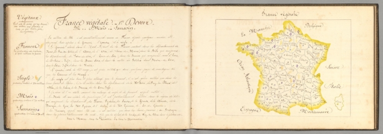
Author
Giraud, Eugénie
Full Title
France végétale (1). (with) (Text Page to) France végétale : 1er devoir.
List No
14321.036
Note
Manuscript map of France, in ink and colored pencil. Title translates to: Vegetables of France. Shows international and administrative boundaries, and coastline. Features agricultural products - with pictorial representation - including wheat, rye, corn and buckwheat. Map is 17 x 23 cm, on sheet 21 x 31 cm. Accompanied by descriptive text and a legend on facing page. Seventh map appearing in the second part of atlas, Principale production de la France en général [= Main production of France in general]. (with) Descriptive text for map, France végétale, on facing page. Text title translates to: Vegetable of France : 1st part. Includes sections: Froment -- Seigle -- Maïs -- Sarrasin [= Wheat -- Rye -- Corn -- Buckwheat]. Appears in the second part of atlas, Principale production de la France en général [= Main production of France in general].
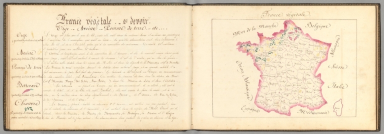
Author
Giraud, Eugénie
Full Title
France végétale (2). (with) (Text Page to) France végétale : 2e devoir.
List No
14321.037
Note
Manuscript map of France, in ink and colored pencil. Title translates to: Vegetables of France. Shows international and administrative boundaries, and coastline. Features agricultural products - with pictorial representation - including barley, oats, potatoes, beet roots and hemp. Map is 17 x 25 cm, on sheet 21 x 31 cm. Accompanied by descriptive text and a legend on facing page. Eighth map appearing in the second part of atlas, Principale production de la France en général [= Main production of France in general]. (with) Descriptive text for map, France végétale, on facing page. Text title translates to: Vegetable of France : 2nd part. Includes sections: Orge -- Avoine -- Pomme de terre -- Betterave -- Chanvre [= Barley -- Oats -- Potato -- Beet root - Hemp]. Appears in the second part of atlas, Principale production de la France en général [= Main production of France in general].
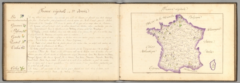
Author
Giraud, Eugénie
Full Title
France végétale (3). (with) (Text Page to) France végétale : 3e devoir.
List No
14321.038
Note
Manuscript map of France, in ink and colored pencil. Title translates to: Vegetables of France. Shows international and administrative boundaries, and coastline. Features agricultural products - with pictorial representation - including flax, saffron and rapeseed. Map is 17 x 25 cm, on sheet 21 x 31 cm. Accompanied by descriptive text and a legend on facing page. Ninth map appearing in the second part of atlas, Principale production de la France en général [= Main production of France in general]. (with) Descriptive text for map, France végétale, on facing page. Text title translates to: Vegetable of France : 3rd part. Includes sections: Lin ... Safran ... Colza [= Flax ... Saffron ... Rapeseed]. Appears in the second part of atlas, Principale production de la France en général [= Main production of France in general].
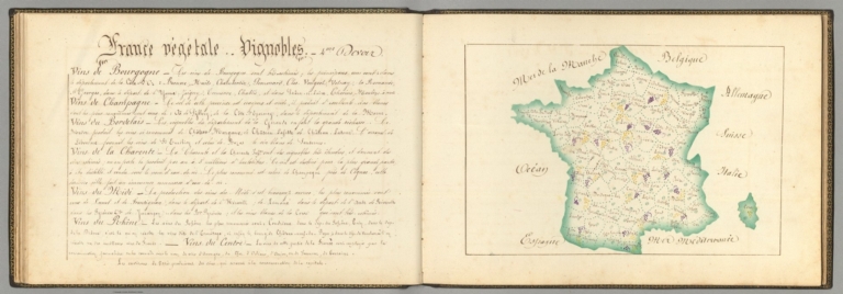
Author
Giraud, Eugénie
Full Title
France végétale (4). (with) (Text Page to) France végétale : Vignobles : 4me devoir.
List No
14321.039
Note
Manuscript map of France, in ink and colored pencil. Title translates to: Vegetables of France. Shows international and administrative boundaries, and coastline. Features vineyards - with pictorial representation - including in the regions of Bourgogne [Burgundy], Champagne, Bordelais and Rhône. Map is 17 x 25 cm, on sheet 21 x 31 cm. Accompanied by descriptive text and a legend on facing page; title taken from text. Tenth map appearing in the second part of atlas, Principale production de la France en général [= Main production of France in general]. (with) Descriptive text for map, France végétale, on facing page. Title translates to: Vegetable of France : Vineyards : 4th part. Includes sections on the regions of Bourgogne [Burgundy], Champagne, Bordelais and Rhône. Appears in the second part of atlas, Principale production de la France en général [= Main production of France in general].
Author
Silishchensky, Mitrofan Ivanovich 1878 - 1944
Full Title
Produkty pitaniya rastitel'nogo proiskhozhdeniya. Prof. M. I. Silishchenskiy. Gos. Kartogr. Institut NTU-VSNKH-SSR. Kartografiya Leningrad. (to accompany) Geograficheskiy atlas Chast 1.
List No
13461.035
Note
World agricultural map, including wheat, sugar, coffee, cocoa, and tea. 2 inset maps: World Map of Vegetable Textile Raw Materials and Food products and raw materials of animal origin, forest and forest products. Includes legend and tables.
Author
Vneshtorgizdat
Full Title
U.S.S.R. our vast home. Vneshtorgizdat, Zakaz No. B-951-44. (cover title) U.S.S.R. Our country. 1958 Bruxelles, U.R.S.S.
List No
13588.003
Author
[U.S. Geological Survey, NASA]
Full Title
Garden City, Kansas. Center pivot irrigation systems created these circular patterns in crop land near Garden City, Kansas. The red circles indicate irrigated crops of healthy vegetation. The light-colored circles represent harvested crops. Landsat 7 data acquired 9/25/2000.
List No
10830.000
Author
[Gill, Leslie MacDonald, 1884-1947, Empire Marketing Board]
Full Title
A Map of New Zealand Portraying Her Agricultural Products & Fisheries.
List No
10811.000
Author
[Gill, Leslie MacDonald, 1884-1947, Empire Marketing Board]
Full Title
Irish Free State & Northern Ireland Portraying Their Agricultural Products & Fisheries 1929
List No
10812.000
Author
[Gill, Leslie MacDonald, 1884-1947, Empire Marketing Board]
Full Title
England. The Crops & Live Stock ... Land ... Fisheries.
List No
10813.000
Author
[Gill, Leslie MacDonald, 1884-1947, Empire Marketing Board]
Full Title
A Map of Scotland Portraying Her Agricultural Products & Fisheries 1929.
List No
10778.000
Author
[Gill, Leslie MacDonald, 1884-1947, Empire Marketing Board]
Full Title
A Map of the Union of South Africa Portraying Her Agricultural Products & Fisheries.
List No
10779.000
Author
Andrews, RJ
Full Title
(Text page to) Cross-Sections Through California. Elevation and land cover data illustrated across 17 profiles and charts showing Valuable Crops, Sources of Electricity, Population Growth, In an Isotype Style. Copyright RJ Andrews 2020. All rights reserved.
List No
10537.002
Author
Andrews, RJ
Full Title
Cross-Sections Through California. 14x vertical exaggeration USGS elevations with symbols showing MLRC National Land Cover Database (2016) in an Isotype style. Copyright RJ Andrews 2020. All rights reserved.
List No
10537.003
Author
W. & A.K. Johnston
Full Title
Johnstons' map of Southern Russia. W. & A.K. Johnston, Engraver & Geographer to the Queen, Edinburgh. (to accompany) Johnstons' atlas of the war-1855. .
List No
8367.015
Note
Hand color map. Showing cattle rearing, and Grain producing districts, major cities, towns and villages, roads, tracks, churches, etc. Includes explanation and notes. Prime meridian is Greenwich.
Author
[Arutiunian, Aramais Bagratovich, Baghdasaryan, Andranik Bakhsii]
Full Title
Anasunner. (to accompany) Atlas Armi︠a︡nskoĭ Sovetskoĭ Sot︠s︡ialisticheskoĭ Respubliki. Erevan - Moskva 1961.
List No
13362.091
Note
Color map of Livestock, with 3 inset maps. Includes legend, graphs and charts. Relief shown by spot heights.
Author
Vuillemin, Alexandre
Full Title
Geographie commerciale et industrielle : Nouvelle carte illustree de l'Amerique du Nord : Indiquant Les Grandes Divisions Physiques, La Distribution Geographique Des Vegetaux Et Mineraux ... Dressee par A. Vuillemin. Gravee par Langevin. Paris, Chez Fatout, Editeur. 1861. Grave sur acier, Grave: la Topographie par Gerin, le trait au burin par F. Lefevre. Les illustrations dessinees par A. Testard et gravees par Guensu. Imprime par Mangeon. Paris. (to accompany) Atlas illustre de geographie commerciale et industrielle.
List No
13376.019
Note
Engraved outline hand color map. Including 16 vignettes views showing indigenous people in North America and 2 sections of fruits and plants in panels at sides. Map shows Russian America, Utah & New Mexico extending to the Rocky Mountains, Oregon, Northwest and Indian Territories, early discoveries, including a reference to Alvaro Nunez in Texas in 1528, Cabrillo's discovery of the Pacific in 1548, Francis Drake, Lewis & Clark and Edwin James. Includes legend, tables, color coded table of European colonies in the region and notes.
Author
Vuillemin, Alexandre
Full Title
Geographie commerciale et industrielle : Nouvelle carte illustree de l'Amerique du Sud : Indiquant Les Grandes Divisions Physiques, La Distribution Geographique Des Vegetaux Et Mineraux ... Dressee par A. Vuillemin. Gravee par Langevin. Paris, Chez Fatout, Editeur. 1861. Grave sur acier, Grave: la Topographie par Gerin, le trait au burin par F. Lefevre. Les illustrations dessinees par A. Testard et gravees par Guensu. Imprime par Mangeon. Paris. (to accompany) Atlas illustre de geographie commerciale et industrielle.
List No
13376.020
Note
Engraved outline hand color map. Inset: Carte donnant les parcours des bateaux a vapeur sur l'Atlantique el l'Océan Pacifique. Including 12 vignettes views of countries in South America and 2 sections of fruits and plants in panels at sides. Includes legend, tables and notes.
Author
Baur, Carl Friedrich
Full Title
Erdkarte. Entworfen u. gezeichnet v. C. F. Baur. Bassermann Verlagshandlung in Mannheim. (to accompany) Atlas fur Handel u. Industrie, fur Kaufleute, Fabrikanten u. Gewerbetreibende ... von C.F. Baur. 1857.
List No
13199.005
Note
Latest color map of the earth, showing political divisions, trade and European colonies. Includes explanation at the foot of map and color reference to European countries and colonies.
Author
Baur, Carl Friedrich
Full Title
Grossbritannien. Entworfen u. gezeichnet v. C. F. Baur. Bassermann' sche Verlagshandlung in Mannheim. (to accompany) Atlas fur Handel u. Industrie, fur Kaufleute, Fabrikanten u. Gewerbetreibende ... von C.F. Baur. 1857.
List No
13199.007
Note
Color map, with inset map of London. Shows major cities, roads, railroads, and shipping routes. Includes reference to agricultural, mineral and industrial products, and table of import and export.
Author
Baur, Carl Friedrich
Full Title
Frankreich. Entworfen u. gezeichnet v. C. F. Baur. Bassermann Verlagshandlung in Mannheim. (to accompany) Atlas fur Handel u. Industrie, fur Kaufleute, Fabrikanten u. Gewerbetreibende ... von C.F. Baur. 1857.
List No
13199.009
Note
Color map, with inset map of Umgebung von Paris. Shows major cities, roads, railroads, and shipping routes. Includes reference to agricultural, mineral and industrial products, and table of import and export.
Author
Baur, Carl Friedrich
Full Title
Vereinigte Staaten und Mexiko. Entworfen u. gezeichnet v. C. F. Baur. Bassermannsche Verlagshandlung in Mannheim. B. Walther lith. (to accompany) Atlas fur Handel u. Industrie, fur Kaufleute, Fabrikanten u. Gewerbetreibende ... von C.F. Baur. 1857.
List No
13199.049
Note
Color map. Includes color coded reference. Shows political and administrative boundaries, major cities, roads and shipping routes. Includes list of 24 States in Unite States and 20 Mexican States.
Author
Emery, Don J.
Full Title
A map of Florida for garden lovers. Published by the Garden Club of the Halifax Country Daytona Beach, Ormand & Ormand Beach. Copyright 1934. Designed by Don J. Emery- Daytona Beach.
List No
13212.002
Note
Pictorial map, bordered with decorative Art Deco illustrations of plants and bird species indigenous to Florida. Shows rich variety of flora, gardens, bird refuges, state parks, national forests, etc. Includes note describing the map, state and Garden Club seals. On verso: Text describing places of interest to lovers of both wild and cultivated gardens.
Author
[Vincey, Paul, France. Ministere de l'Agriculture]
Full Title
Carte agronomique des environs de Paris. Departement de la Seine. Dressee par order du Ministere de l'Agriculture. et du Prefet. de la Seine ... Par Mr. Paul Vincey. Chromolith. chez L. Wuhrer. Imp. Erhard, Paris. (to accompany) Album de statistique agricole et carte agronomique du departement de la Seine ... par M. Paul Vincey ... 1897. (inset) Profil geologique suivant A.B.
List No
13087.007
Note
Color folded agronomic map. Shows geologic formations, roads, railroads, place names and rivers. Includes descriptive text, charts and legends. Relief shown by contours and spot heights.
Author
[Vincey, Paul, France. Ministere de l'Agriculture]
Full Title
Departement de la Seine : Statistique agricole en 1894 : Repartition des cultures en grandes divisions. Grave chez L. Wuhrer; Ch. Labau del. (to accompany) Album de statistique agricole et carte agronomique du departement de la Seine ... par M. Paul Vincey ... 1897.
List No
13087.008
Note
Color statistical map. Includes descriptive text, statistical tables and key to cultivated area.
Author
[Vincey, Paul, France. Ministere de l'Agriculture]
Full Title
Departement de la Seine : Statistique agricole en 1894 : Redenment du froment par hectare du surface encemencee. Grave chez L. Wuhrer; Ch. Labau del. (to accompany) Album de statistique agricole et carte agronomique du departement de la Seine ... par M. Paul Vincey ... 1897.
List No
13087.012
Note
Color map of France. Includes descriptive text, and color coded key.
Author
[Vincey, Paul, France. Ministere de l'Agriculture]
Full Title
Departement de la Seine : Statistique agricole en 1893 : Repartition des animaix domestiques. Grave chez L. Wuhrer; Ch. Labau del. (to accompany) Album de statistique agricole et carte agronomique du departement de la Seine ... par M. Paul Vincey ... 1897.
List No
13087.018
Note
Color map of France. Includes statistical tables, text, and color coded key.
Author
France. Ministere de l'agriculture
Full Title
I. Percentage of the various areas making up the total territory of France par department en 1882. Imp. Clerc et Catineau - Paris. (in upper margin) Ministere de l'Agriculture. Album de statistique agricole,1887.
List No
13085.008
Note
Map showing percentage of the various areas making up the total territory of France. Insets: France; Seine; Algerie; Corse. Includes legend and color coded key.
Author
France. Ministere de l'agriculture
Full Title
II. Surface ensemencee en cereales par 100 hectares du territoire total en 1882. E' carts des moyennes departmentales par rapport a la moyenne generale. Imp. Clerc et Catineau - Paris. (in upper margin) Ministere de l'Agriculture. Album de statistique agricole,1887.
List No
13085.009
Note
Map showing of grain planting areas per 100 hactares of the total territory in 1882 and the departmental average in relation to the general average. Insets: Algerie; Corse. Includes legend and color coded key.
Author
[Silk, D. Wenaslin, Cavalcanti, Manoel Paulino, Sociedade Nacional de Agricultura (Brazil). Seccao de Geographia Agricola]
Full Title
Sociedade Nacional de Agricultura. Seccao Geographia Agricola : Grande premio na Expisicao Nacional de 1908. (Gradn prix a l'Exposicao Nacional 1908). Ensaio de mappa geologico do Brazil (Etude de carte geologique du Bresil). Visto, D. Wenaslin Silk. Organisado por M. Paulino Cavalcanti. Seccao Cartographica do Estabelecimento Graphico - Weiszflog, Irmaos - S. Paulo. (to accompany: Atlas do Brazil).
List No
11947.003
Note
Geological map of Brazil. Shows administrative divisions, rivers, forests and mountains. Relief shown by hachures. Includes legend.
Author
[Silk, D. Wenaslin, Cavalcanti, Manoel Paulino, Sociedade Nacional de Agricultura (Brazil). Seccao de Geographia Agricola]
Full Title
Sociedade Nacional de Agricultura. Seccao Geographia Agricola : Grande premio na Expisicao Nacional de 1908. (Gradn prix a l'Exposicao Nacional 1908). Ensaio de mappa agrologico do Brazil (Etude de carte agrologique du Bresil). Visto, D. Wenaslin Silk. Organisado por M. Paulino Cavalcanti. Seccao Cartographica do Estabelecimento Graphico - Weiszflog, Irmaos - S. Paulo. (to accompany: Atlas do Brazil).
List No
11947.004
Note
Agrological map of Brazil. Shows types of soil, administrative divisions, major cities, rivers, etc. Relief shown by hachures. Includes legend.
Author
[Silk, D. Wenaslin, Cavalcanti, Manoel Paulino, Sociedade Nacional de Agricultura (Brazil). Seccao de Geographia Agricola]
Full Title
Sociedade Nacional de Agricultura. Seccao Geographia Agricola : Grande premio na Expisicao Nacional de 1908. (Gradn prix a l'Exposicao Nacional 1908). Mappa demographico do Brazil (Carte demographique du Bresil). Visto, D. Wenaslin Silk. Organisado por M. Paulino Cavalcanti. Seccao Cartographica do Estabelecimento Graphico - Weiszflog, Irmaos - S. Paulo. (to accompany: Atlas do Brazil). (inset) America d Sul. Diagramma da populacao absouluta.
List No
11947.007
Note
Demographic map of Brazil, with diagram of the population of South America. Shows administrative divisions, major cities, rivers, forests and mountains. Relief shown by hachures. Includes legend.
Author
[Woodbridge, William C., Willard, Emma]
Full Title
(World) View of Climates and Productions; Drawn from the accounts of Humboldt, Mirbel, Buffon, and others.
List No
12497.013
Author
Gill, Leslie MacDonald, 1884-1947
Full Title
Map of Ceylon, showing her Tea & other industries.
List No
10047.000
Note
This is a larger version with different title and representation of the ocean compared to our smaller 12060.000
Author
Gill, Leslie MacDonald, 1884-1947
Full Title
Ceylon, her Tea and other industries.
List No
12060.000
Note
Date estimated.
Author
Gill, Leslie MacDonald, 1884-1947
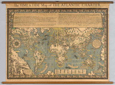
Full Title
The "Time & Tide" Map of The Atlantic Charter.
List No
7864.000
Note
At the head of the map is a lengthy quote from the Atlantic Charter, with the signatures of Franklin Roosevelt and Winston Churchill. The Atlantic Charter was a pivotal policy statement issued in August 1941 that, early in World War II, defined the Allied goals for the post-war world. It was drafted by the leaders of Britain and the United States, and later agreed to by all the Allies. Dramatic graphics with vignettes representative of various crops and resources. Statements espousing peace.
Author
Baker, Oliver Edwin
Full Title
Atlas of American Agriculture. Physical Basis including Land Relief, Climate, Soils, and Natural Vegetation of the United States. Prepared under the Supervision of O.E. Baker, Bureau of Agricultural Economics. Contributions from the Weather Bureau, Willis R. Gregg, Chief; Bureau of Chemistry and Soils, H.G. Knight, Chief; Bureau of Plant Industry, Frederick D. Richey, Chief; Forest Service, F.A. Silcox, Chief; Bureau of Agricultural Economics, A.G. Black, Chief. United States Department of Agriculture, Washington, D.C., United States Government Printing Office, Washington: 1936.
List No
5797.158
Note
This is the flip book reader version of the atlas.
Author
Andreas, A. T. (Alfred Theodore), 1839-1900
Full Title
Agricultural productions colored by grades to show quantity raised in localities. From the ninth census. Wheat, hay, corn, cotton, tobacco. (Published by the Andreas Atlas Co., Lakeside Building, Chicago, Ills. Engraved & printed by Chas. Shober & Co., Props. of Chicago Lithographing Co.)
List No
0018.018
Note
Five col. lithographed maps.
Author
[Andreas, A. T. (Alfred Theodore), 1839-1900, Baskin, Forster and Company]
Full Title
Agricultural productions colored by grades to show quantity raised in localities. From the ninth census. Wheat, hay, corn, cotton, tobacco. (Published by Baskin, Forster & Co. Lakeside Building Chicago, Ills. 1876. Engraved & Printed by Chas. Shober & Co. Props. of Chicago Lithographing Co.)
List No
0019.009
Note
Five col. lithographed maps.
Author
Cartee, Cornelius S.
Full Title
The distribution of trees, shrubs, grains & fruits. According to zones of climate & moisture. Designed To Accompany Cartee's "Elements Of Physical Geography. Engraved by G.W. Boynton. Entered ... 1856, by Hickling, Swan, And Brown ... Massachusetts. (to accompany) A School Atlas Of Physical Geography ... By Cornelius S. Cartee, A.M. M DCCC LVI. (inset) Distribution of plants in a vertical direction.
List No
0129.015
Note
Engraved hand color map. Color on the inset correspond with those on the map. Prime meridian is Greenwich.
Author
Johnston, Alexander Keith
Full Title
The Distribution of the Most Important Trees, Shrubs, Grains, & Fruits According to Zones of Climate & Moisture.
List No
0370.023
Note
Includes mountain profile.
Author
[Henfrey, Arthur, 1819-1859, Johnston, Alexander Keith, 1804-1871]
Full Title
Map of the geographical distribution of the most important plants yielding food, including the cultivated grains and other cultivated and wild bread plants with indications of the principal fruits; laid down in connection with climatal conditions for Keith Johnston's Physical atlas by Arthur Henfrey, F.R.S; F.L.S. &c. Engraved & printed in colours by W. & A.K. Johnston, Edinburgh. William Blackwood & Sons, Edinburgh & London. 1st. March 1854, (1856)
List No
0372.025
Note
Col. lithographed map. Insets: Map of the distribution of the principal food plants, fruits & characteristic trees of Western & Central Europe -- Map of the distribution of the more important plants, yielding materials for beverages, spices, dyes, and other economical substances; and growing in the warmer regions of the globe -- Map of the distribution of tea & the principal spices grown in the East Indies -- Two sections from S. to N. in Western & Central Europe, showing the distribution of the principal food plants according to altitude -- Two sections showing approximatively the distribution of the most important economical plants according to altitude, Western Hemisphere, Eastern Hemisphere. "Phytology & zoology no. 1."
Author
Henfrey, Arthur, 1819-1859
Full Title
On the Geographical Distribution of Plants Yielding Food.
List No
0372BN
Author
Henfrey, Arthur, 1819-1859
Full Title
On the Geographical Distribution of Plants Yielding Food. (continued)
List No
0372BO
Author
Larousse
Full Title
France Agricole et Industrielle.
List No
0418.051
Author
[Paullin, Charles O., Wright, John K.]
Full Title
Plate 142. Agriculture. Agricultural Regions, 1924. Cotton Production, 1839. Cotton Production, 1859. Cotton Production, 1889. Cotton Production, 1919. Cotton Production, 1924.
List No
0702.145
Author
[Paullin, Charles O., Wright, John K.]
Full Title
Plate 143. Agriculture. Cattle (Excluding Milch Cows), 1860. Cattle (Excluding Milch Cows), 1890. Cattle (Excluding Milch Cows), 1920. Cattle and Calves, 1925. Tobacco Production, 1839. Tobacco Production, 1859. Tobacco Production, 1889. Tobacco Production, 1919. Tobacco, Rice and Flax, 1924. Corn Production, 1839. Corn Production, 1859. Corn Production, 1889. Corn Production, 1919. Corn for Grain Production, 1924. Wheat Production, 1839. Wheat Production, 1859. Wheat Production, 1889. Wheat Production, 1919.
List No
0702.146
Author
[Paullin, Charles O., Wright, John K.]
Full Title
Plate 144. Agriculture. Spring Wheat Production, 1924. Winter Wheat Production, 1924. Improved Land, 1850. Improved Land, 1860. Improved Land, 1870. Improved Land, 1880. Improved Land, 1890. Improved Land, 1900.
List No
0702.147
Author
[Paullin, Charles O., Wright, John K.]
Full Title
Plate 145. Agriculture. Improved Land, 1910. Land in Harvested Crops, 1919. Land in Harvested Crops, 1929. Improved Land, 1850 - 1860. Improved Land, 1860 - 1870. Improved Land, 1880 - 1890. Improved Land, 1890 - 1900.
List No
0702.148
Author
[Paullin, Charles O., Wright, John K.]
Full Title
Plate 146. Agriculture. Improved Land, 1900 - 1910. Improved Land, 1910 - 1920. Land in Harvested Crops, 1909 - 1924. Improved Land, 1850 - 1860. Improved Land, 1860 - 1870. Improved Land, 1870 - 1880. Improved Land, 1880 - 1890. Improved Land, 1890 - 1900. Improved Land, 1900 - 1910. Land in Harvested Crops, 1909 - 1924. Land in Harvested Crops, 1924 - 1929. Tenant Farmers, 1880. Tenant Farmers, 1900. Tenant Farmers, 1920. Tenant Farmers, 1930.
List No
0702.149
Author
[Paullin, Charles O., Wright, John K.]
Full Title
Plate 147. Agriculture. Farm Lands and Buildings, 1850. Farm Lands and Buildings, 1880. Farm Lands and Buildings, 1910. Farm Lands and Buildings, 1930. Farm Implements and Machinery, 1850. Farm Implements and Machinery, 1880. Farm Implements and Machinery, 1910. Farm Implements and Machinery, 1930.
List No
0702.150
Author
Polish Army Topography Service
Full Title
Population. Pergamon World Atlas. Pergamon Press, Ltd. & P.W.N. Poland 1967. Sluzba Topograficzna W.P.
List No
0737.028
Note
Six maps of attributes of population: races, languages, growth, urbanization, and agricultural employment.
Author
Polish Army Topography Service
Full Title
Land Use. Pergamon World Atlas. Pergamon Press, Ltd. & P.W.N. Poland 1967. Sluzba Topograficzna W.P.
List No
0737.032
Note
Land use in six categories: arable, pasture, tropical grazing, some grazing, forest, and non-agricultural lands.
Author
Polish Army Topography Service
Full Title
Types of Agriculture. Pergamon World Atlas. Pergamon Press, Ltd. & P.W.N. Poland 1967. Sluzba Topograficzna W.P.
List No
0737.033
Note
Based on nineteen categories of agricultural land use.
Author
Polish Army Topography Service
Full Title
Agriculture. Pergamon World Atlas. Pergamon Press, Ltd. & P.W.N. Poland 1967. Sluzba Topograficzna W.P.
List No
0737.034
Note
Six agricultural maps: land and property ownership, farm size, artificial fertilizers and tractors, bread grains, rice, and barley and oats.
Author
Polish Army Topography Service
Full Title
Agriculture (continued). Pergamon World Atlas. Pergamon Press, Ltd. & P.W.N. Poland 1967. Sluzba Topograficzna W.P.
List No
0737.035
Note
Six agricultural maps: sucrose plants, oleaginous plants, fibros plants, viticulture and wine production, fruit growing, and stimulants and condiments.
Author
Polish Army Topography Service
Full Title
Agriculture (continued). Pergamon World Atlas. Pergamon Press, Ltd. & P.W.N. Poland 1967. Sluzba Topograficzna W.P.
List No
0737.036
Note
Six agricultural maps: tuberous plants, cattle, pigs, sheep and goats, draught and pack animals, and types of animal husbandry..
Author
Polish Army Topography Service
Full Title
Agriculture. Pergamon World Atlas. Pergamon Press, Ltd. & P.W.N. Poland 1967. Sluzba Topograficzna W.P.
List No
0737.037
Note
Three agricultural maps: forests, production of wood products, and fishing.
Author
Raisz, Erwin
Full Title
Agriculture. By Erwin Raisz. (index numbers) after D.S. Whittlesey. (to accompany) Atlas Of Global Geography. By Erwin Raisz. Lectures in Cartography, Institute Of Geographical Exploration, Harvard University, Cambridge, Mass. ... Global Press Corporation, Publishers. New York, N.Y. Sole Distributors: Harper & Brothers, New York. (on verso) Copyright 1944, by Global Press Corporation.
List No
0744.032
Note
Color maps. Accompanied by text, and reference charts. Relief shown pictorially. With paper dust jacket. On the jacket it states that this is an "entirely new kind of atlas - A beautiful and informative book of 'global' maps, giving a plane's-eye view of tomorrow's geography..."
Author
Thompson & West
Full Title
French merino sheep, property of Mrs. R. Blacow, Alameda Co., Cal., P.O. address Centreville. (Published by Thompson & West, Oakland, Cala., 1878)
List No
0999.012
Note
Lithographed view.
Author
Thompson & West
Full Title
Res. of Mrs. R. Blacow, Alameda Co., Cal. Res. & farm of Mrs. R. Blacow ... P.O. address Centerville, Alameda Co., Cal. (Published by Thompson & West, Oakland, Cala., 1878)
List No
0999.013
Note
Two lithographed views on 1 sheet.
Author
Thompson & West
Full Title
Res. of John Hall, Alvarado, Washington Tp., California. Farm & res. of John Hall, Alvarado, Alameda Co., Cal. (Published by Thompson & West, Oakland, Cala., 1878)
List No
0999.015
Note
Two lithographed views on 1 sheet. Includes Hall's Station, on the South Pacific Coast Rail Road Co.
Author
Thompson & West
Full Title
Stock & farm of M.B. Sturges, Alameda Co., Cal. Res. & stock of M.B. Sturges ... P.O. address Centreville, Alameda Co., California. (Published by Thompson & West, Oakland, Cala., 1878)
List No
0999.016
Note
Two lithographed views on 1 sheet.
Author
Thompson & West
Full Title
Res. & farm of H. Curtner, Harrisburg, Alameda County, Cal. Res. & farm of H. Curtner ... looking west. (Published by Thompson & West, Oakland, Cala., 1878)
List No
0999.018
Note
Two lithographed views on 1 sheet.
Author
Thompson & West
Full Title
Res. & ranch of Richard Dowling, Brooklyn Tp. ... Residence of P.F. Marston, Fruit Vale Ave. ... (both) Alameda Co., Cal. (Published by Thompson & West, Oakland, Cala., 1878)
List No
0999.027
Note
Two lithographed views on 1 sheet.
Author
Thompson & West
Full Title
Farm & res. of Michael Curtis ... Poirier Tract of Mrs. DeLima Poirier ... (both) Berkley (sic), Alameda Co., Cal. (Published by Thompson & West, Oakland, Cala., 1878)
List No
0999.030
Note
Two lithographed views on 1 sheet. Poirier Tract is bird's eye view showing street names, lot numbers, etc.
Author
Thompson & West
Full Title
Residence & farm of E. Dyer, Murray Tp., Alameda Co., Cal. (P.O. Altamont, Cal.) Property of Meritz Hupers, Livermore, Alameda Co., Cal. (Published by Thompson & West, Oakland, Cala., 1878)
List No
0999.031
Note
Two lithographed views on 1 sheet. Hupers view includes building called Farmers Exchange.
Author
Thompson & West
Full Title
Residence & farm of R.S. Farrelly, Brooklyn Tp., Alameda County, Cal. Residence and farm of John Mathews, Brooklyn Tp., Alameda Co., Cal. (Published by Thompson & West, Oakland, Cala., 1878)
List No
0999.034
Note
Two lithographed views on 1 sheet.
Author
Thompson & West
Full Title
Residence & farm of Nicholaus Gading, Eden Tp., Alameda Co., Cal. Residence & fruit farm of Wm. H. Jessup, Haywards, Alameda County, Cal. (Published by Thompson & West, Oakland, Cala., 1878)
List No
0999.039
Note
Two lithographed views on 1 sheet. Both are low oblique views.
Author
Thompson & West
Full Title
Res. & farm of E. Munyan, Centerville ... Property of W.W. Armstrong, Brooklyn Tp. ... Res. & farm of Jas. F. Kapp, Pleasanton ... (all) Alameda Co., Cal. (Published by Thompson & West, Oakland, Cala., 1878)
List No
0999.040
Note
Three lithographed views on 1 sheet. Armstrong view shows "Halfway House."
Author
Thompson & West
Full Title
Residence of Geo. Obermuller ... Property of Henry Hooz. Residence & farm of John C. Wille, Mt. Eden ... (both) Eden Tp., Alameda County, Cal. (Published by Thompson & West, Oakland, Cala., 1878)
List No
0999.048
Note
Two lithographed low oblique bird's-eye views on 1 sheet.
Author
Thompson & West
Full Title
Res. and farm of Fred Wrede ... Res. and farm of H.F. Nebas, ... (both) Eden Tp., Alameda County, Cal. (Published by Thompson & West, Oakland, Cala., 1878)
List No
0999.049
Note
Two lithographed low oblique bird's-eye views on 1 sheet.
Author
Thompson & West
Full Title
Res. & farm of Edward Eichler ... Res. and farm of George Meyer ... (both) Eden Tp., Alameda Co., Cal. (Published by Thompson & West, Oakland, Cala., 1878)
List No
0999.051
Note
Two lithographed low oblique bird's-eye views on 1 sheet.
Author
Thompson & West
Full Title
Residence & farm of S. Huff, San Leandro ... Residence of William Owen, Hayward ... (both) Alameda Co., Cal. (Published by Thompson & West, Oakland, Cala., 1878)
List No
0999.052
Note
Two lithographed low oblique bird's-eye views on 1 sheet.
Author
Thompson & West
Full Title
Residence & agricultural works of Henry Mininger, Mt. Eden ... Residence & farm of O. Dennis ... Residence & farm of F. Hauschildt ... (all) Alameda Co. (or County), Cal. (Published by Thompson & West, Oakland, Cala., 1878)
List No
0999.054
Note
Three lithographed low oblique bird's-eye views. Mininger view includes Mount Eden Agricultural Works and school house.
Author
Thompson & West
Full Title
Residence of Diedrich Pestdorf, Eden Tp., Alameda Co. (with) Salt works of Diedrich Pestdorf. (with) "Ned Forest," owned by Diedrich Pestdorf. (Published by Thompson & West, Oakland, Cala., 1878)
List No
0999.057
Note
Two lithographed low oblique bird's-eye views on 1 sheet. Ned Forest is a horse.
Author
Thompson & West
Full Title
Res. and landing of Capt. Wm. Roberts, San Lorenzo, Alameda County, Cal. (Published by Thompson & West, Oakland, Cala., 1878)
List No
0999.058
Note
Two lithographed low oblique bird's-eye views on 1 sheet. Upper view has separate title: "Robert's Landing," Capt. Wm. Roberts, prop.
Author
Thompson & West
Full Title
Property of Henry Smyth, San Lorenzo ... (with) Residence and farm of James Adams, Eden Tp. ... (both) Alameda Co., Cal. (Published by Thompson & West, Oakland, Cala., 1878)
List No
0999.060
Note
Two lithographed low oblique bird's-eye views on 1 sheet. Building in upper view named "H. Smyth's Alameda County Agricultural Works."
Author
Thompson & West
Full Title
Res. and farm of Lewis Knox ... Res. and farm of Leonard Stone ... (both) Eden Tp., Alameda Co., Cal. (Published by Thompson & West, Oakland, Cala., 1878)
List No
0999.061
Note
Two lithographed low oblique bird's-eye views on 1 sheet.
Author
Thompson & West
Full Title
Residence and farm of Daniel Inman, Esq., Livermore, Alameda County, California. (Published by Thompson & West, Oakland, Cala., 1878)
List No
0999.063
Note
Lithographed low oblique bird's-eye view.
Author
Thompson & West
Full Title
Res. & stock farm of J.T. Walker, Washington Corners, Alameda Co., Cal. Res. and farm of Christian Knittel, Murray Tp., Alameda County, Cal. (Published by Thompson & West, Oakland, Cala., 1878)
List No
0999.064
Note
Two lithographed low oblique bird's-eye views on 1 sheet.
Author
Thompson & West
Full Title
Res. & farm of Joseph F. Black, Pleasanton, Alameda County, Cal. Res. & sulphur springs of J.A. Neal, Pleasanton, Alameda Co., Cal. (Published by Thompson & West, Oakland, Cala., 1878)
List No
0999.066
Note
Two lithographed low oblique bird's-eye views on 1 sheet.
Author
Thompson & West
Full Title
Res. & farm of Carl G. Munch, Murray Tp., Alameda Co., Cal. Res. & farms of Geo. C. Stanley, Livermore, Alameda Co., Cal., showing his Las Posetas (i.e., Positas) Ranch in distance. (Published by Thompson & West, Oakland, Cala., 1878)
List No
0999.067
Note
Two lithographed low oblique bird's-eye views on 1 sheet.
Author
Thompson & West
Full Title
Res. of Hon. J. Beazell, Livermore, Alameda Co., Cal. Res. & farm of John English, Pleasanton, Alameda County, California. (Published by Thompson & West, Oakland, Cala., 1878)
List No
0999.069
Note
Two lithographed low oblique bird's-eye views on 1 sheet.
Author
Thompson & West
Full Title
Res. & farms of Duerr & Nusbaumer, Sunol, Alameda Co., Cal. East view showing Vallecitos Ranch in distance. T.F. Bachelder's Ranch ... Sunol, Alameda County, Cal. (Published by Thompson & West, Oakland, Cala., 1878)
List No
0999.070
Note
Two lithographed low oblique bird's-eye views on 1 sheet.
Author
Thompson & West
Full Title
Res. & farms of Robert Livermore, Livermore, Alameda Co., Cal. El Valle de San Jose Rancho ... Las Positas Rancho ... Res. and hotel of A. Bardellini, Livermore, Alameda Co., Cal. (Published by Thompson & West, Oakland, Cala., 1878)
List No
0999.073
Note
Three lithographed views on 1 sheet. Low oblique bird's-eye views. Engraver name illegible. Bardellini building is called Washington Hotel.
Author
Thompson & West
Full Title
Res. & farm of George May, Livermore, Alameda County, Cal. Res. of Israel Horton, Livermore, Alameda Co., Cal. (Published by Thompson & West, Oakland, Cala., 1878)
List No
0999.076
Note
Two lithographed views on 1 sheet. Low oblique bird's-eye views. Signs on windmills in views: Horton & Kenedy, Livermore -- Horton & Kenedy, Genl. agents, Livermore, Cal.
Author
Thompson & West
Full Title
Race-track & residence of Joseph Nevis, Pleasanton, California. Residence & farm of John Green, Dublin, Alameda Co., Cal. (Published by Thompson & West, Oakland, Cala., 1878)
List No
0999.077
Note
Four lithographed views on 1 sheet. Low oblique bird's-eye views. Titles on upper views: Pleasanton Race Track -- Property of John Green, Dublin, Alameda Co., Cal. (showing "John Green's" and "Amador Hotel."). Lower Nevis view includes I.O.O.F. hall.
Author
Thompson & West
Full Title
Residence & stock farm of H. Egger, Centreville, Alameda County, Cal. Residence & farm of I.B. Haines, Alvarado, Alameda County, California. (Published by Thompson & West, Oakland, Cala., 1878)
List No
0999.080
Note
Two lithographed views on 1 sheet. Low oblique bird's-eye views.
Author
Thompson & West
Full Title
Res. & farm of John L. Beard ... "Alvarado Salt Works," John Quigley, proprietor ... (both) Alvarado, Alameda Co., Cal. (Published by Thompson & West, Oakland, Cala., 1878)
List No
0999.081
Note
Two lithographed views on 1 sheet. Low oblique bird's-eye views.
Author
Thompson & West
Full Title
Res. and farm, 100 acres, of L.E. Osgood ... Res. and farm of Ashley Cameron ... (both) Centreville, Alameda Co., Cal. (Published by Thompson & West, Oakland, Cala., 1878)
List No
0999.084
Note
Two lithographed views on 1 sheet. Low oblique bird's-eye views.
Author
Thompson & West
Full Title
Res. & farm of G.M. Walters, Washington Corners, Alameda Co., Cal. Res. & grounds of H. Crowell, Washington, Alameda Co., California. (Published by Thompson & West, Oakland, Cala., 1878)
List No
0999.085
Note
Two lithographed views on 1 sheet. Walters view is low oblique bird's-eye.
Author
Thompson & West
Full Title
Res. & farm of J.C. Whipple, Alvarado, Alameda County, California. (Published by Thompson & West, Oakland, Cala., 1878)
List No
0999.086
Note
Lithographed view on 1 sheet. Low oblique bird's-eye view.
Author
Thompson & West
Full Title
Residence of D.M. Sanborn, Esq., Niles, Alameda County, California. (Published by Thompson & West, Oakland, Cala., 1878)
List No
0999.087
Note
Lithographed view on 1 sheet. Shows also animals, farm buildings and surroundings. Low oblique bird's-eye view.
Author
Thompson & West
Full Title
Residence & ground of Hon. M.W. Dixon, Harrisburg, Alameda Co., Cal. (Published by Thompson & West, Oakland, Cala., 1878)
List No
0999.088
Note
Lithographed view on 1 sheet. Low oblique bird's-eye view.
Author
Thompson & West
Full Title
Res. & farm of A. Patterson, Alvarado, Alameda Co., California. (Published by Thompson & West, Oakland, Cala., 1878)
List No
0999.089
Note
Lithographed view on 1 sheet. Low oblique bird's-eye view.
Author
Thompson & West
Full Title
Residence and grounds of G.W. Patterson ... Landing and farm of G.W. Patterson ... (both) Alvarado, Alameda County, California. (Published by Thompson & West, Oakland, Cala., 1878)
List No
0999.090
Note
Two lithographed views on 1 sheet. Landing and farm view is low oblique bird's-eye.
Author
Thompson & West
Full Title
Res. & farm of Jno. A. Bunting ... Res. of Howard Overacker, Esq. ... (both) Centreville, Alameda Co., California. (Published by Thompson & West, Oakland, Cala., 1878)
List No
0999.091
Note
Two lithographed views on 1 sheet. Low oblique bird's-eye views.
Author
Thompson & West
Full Title
Residence & farm of C.S. Haley, Newark, Alameda Co., Cal. (Published by Thompson & West, Oakland, Cala., 1878)
List No
0999.092
Note
Low oblique lithographed bird's-eye view.
Author
Thompson & West
Full Title
Res. & grounds of Captain C. Valpey ... Res. & farm of A. Whisman ... (both) Harrisburg, Alameda Co., Cal. (Published by Thompson & West, Oakland, Cala., 1878)
List No
0999.093
Note
Two lithographed low oblique bird's-eye views on 1 sheet.
Author
Thompson & West
Full Title
Res. & farm of Antonio Rose, Centerville, Alameda County, California. "Warm Spring Landing." Rider, Somers & Co., props., Washington Tp., Alameda Co., California. (Published by Thompson & West, Oakland, Cala., 1878)
List No
0999.094
Note
Two lithographed low oblique bird's-eye views on 1 sheet. Names above title of Warm Spring Landing view: J.B. Rider, Joshua Chadbourn, H.C. Somers.
Author
Thompson & West
Full Title
Res. of M.J. Overacker, Niles, Alameda Co., California. Res. & farm of Geo. Emerson, Decota (sic), Washington Tp., Alameda Co., Cal. (Published by Thompson & West, Oakland, Cala., 1878)
List No
0999.095
Note
Two lithographed low oblique bird's-eye views on 1 sheet.
Author
Thompson & West
Full Title
Residence & farm of John Proctor, Centreville, Alameda County, California. (Published by Thompson & West, Oakland, Cala., 1878)
List No
0999.099
Note
Lithographed low oblique bird's-eye view.
Author
Kellogg Company
Full Title
Map of the gifts of nature to America. Kellogg Company. H.E. 34. Copr. 1932 by Kellogg Co. Printed in U.S.A.
List No
11005.002
Note
Color pictorial map of the United States. 29x43, folds to 9.5x22 in mailer envelope " from Home Economic Department Kellogg's in Battle Creek, Mich. to Mr. Ed. Collins, Boscobel, Wis. 3." Map includes text box on the bottom left and right "The story of Indian Corn" and "Facts about Kellogg's. Shows state boundaries, major cities, agriculture products, industry, livestock, forests, and compass rose oriented with the north to upper left margin. Small inset photos show original home of Corn Flakes - 1906 on top, and Home of Kellog's , Battle Creek, Mich." on the bottom. On verso: a printed form of letter headed " "A message to teachers" from Kellogg's Home Economic Department, signed by Barbara B. Brooks. and illustrated page titled "the story of corn and Corn flakes".
Author
[Gorkin, Aleksandr Fedorovich, Motylev, V.E.]
Full Title
Mirove zemledeliia. (inset) Mirovaia karta posevov pshenitsy i risa. (with) B. Oroshayemykh ploshchadey. (to accompany) Bolshoi Sovietskii Atlas Mira. Moskva 1937.
List No
11008.072
Note
2 color maps of the world with inset on 2 sheets. Showing agricultural products including wheat and rice, in the world. Includes legend and list of agricultural areas by country.
Author
[Gorkin, Aleksandr Fedorovich, Motylev, V.E.]
Full Title
Karta melioratsii v SSSR. (with) Vazhneyshie tekhnicheskie kultury v SSSR. (with 2 insets). (to accompany) Bolshoi Sovietskii Atlas Mira. Moskva 1937.
List No
11008.164
Note
2 color maps on 2 sheets, with 2 insets of cotton crops. Showing land reclamation and important industrial crops in Russia. Include explanation to symbols, and table.
Author
[Gorkin, Aleksandr Fedorovich, Motylev, V.E.]
Full Title
Zemledelnie Soiuza SSR. (to accompany) Bolshoi Sovietskii Atlas Mira. Moskva 1937.
List No
11008.166
Note
Color map on 2 sheetss. Showing agricultural areas in Russia. Include explanation to symbols, statistical table, chart and graphs. .
Author
[Gorkin, Aleksandr Fedorovich, Motylev, V.E.]
Full Title
Zhivotnovodstvo Soiuza SSR. : Loshdi. (with) Ovtsy i kozy. (with) Svini. (with) Krupnyi rogatyi skot i oleni. (to accompany) Bolshoi Sovietskii Atlas Mira. Moskva 1937.
List No
11008.168
Note
4 color maps on 2 sheets, with 3 insets. Showing animal husbandry establishments and areas with highest density of horse, sheep and goats, pigs, cattle and deer in Russia. Include explanation to symbols, statistical table, chart and graphs.
Author
[Gorkin, Aleksandr Fedorovich, Motylev, V.E.]
Full Title
(Covers to) Karty kollektivizatsii krestianskikh khoziaistv v SSSR. (na 1928, 1930, 1933 i 1936 r.g.). Karta Mashinno-traktornykh stantsii v SSSR. Karta Sovkhozv v SSSR. (to accompany) Bolshoi Sovietskii Atlas Mira. Moskva 1937.
List No
11008.169
Note
Cover to maps of collectivization of farms in Russia between 1928-1936.
Author
[Gorkin, Aleksandr Fedorovich, Motylev, V.E.]
Full Title
Kollektivizatsiia krestianskikh khoziaistv v SSSR. (with) Mashinno-traktornye stantsii v SSSR. (with) Sovkhozy v SSSR. (to accompany) Bolshoi Sovietskii Atlas Mira. Moskva 1937.
List No
11008.170
Note
3 color maps on 3 sheets. Showing collectivization of farms in Russia in 4 maps between 1928, 1930, 1933, 1936. Map showing machinery and tractor stations in Russia. and map of Sovkhozes in Russia. Include explanation to symbols, chart and graphs.
Author
United Fruit Company
Full Title
Bananaland : Middle America. 1958 United Fruit company. Litho. in U.S.A.
List No
11240.000
Note
Pictorial map of Central America, 42x39, on sheet 55x80. Shows United Fruit Company's steamship routes and capitals. Relief shown by shadings. Includes 8 illustrated explanatory notes on banana production n Central America on left and right sides of the map, and note on people, agriculture, mineral resources and imports on lower margin.
Author
Sample, Paul
Full Title
Paul Sample's America, its soil. 1946, by Paul Sample. Produced in U.S.A.
List No
11368.000
Note
Color pictorial map of the United States, with scenes of land use and farming. Shows state boundaries, agricultural, industrial, fishing and wooded areas. Relief shown pictorially.
Author
McCormick & Co
Full Title
McCormick's map of the world. (Cover title) From Singapore to Baltimore. Published by McCormick & Co., Inc. Baltimore, Maryland. M-2694-M-250-733.
List No
11471.003
Note
Color pictorial world map on sheet 46.5x41.5, folded into self wrapped cover 23x10. With vignette illustrations at corners. At lower center is an image of the McCormick building. Beneath the map is a selection of products for the Bee Brand and flags of countries with population. Includes compass rose decorated with Bee Brand trade marks. Shows explorer's routes, the spices exported from countries around the world and little vignette illustrations include planes and ships. On verso: text, and uncolored views of various plants, and products manufactured at McCormick Company. Date estimated.
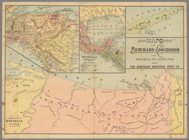
Author
Burchard Honduras Fruit Company
Full Title
Maps of the Burchard : Concession in the Republic of Honduras owned by the Burchard Honduras Fruit Co. Map of Honduras. Honduras in its relations to the United States, etc. Ruatan Island. Map showing the north coast of Honduras from Truxillo to Black River. (cover title) Prospectus of The Burchard Honduras Fruit Company. Main Office, Chicago, Ill. Manager's office, Ruatan, Hondoras.
List No
11547.002
Note
4 Color maps on 1 sheet 40.5x55, folded to 20.5x14. With text on verso. Maps showing political and administrative boundaries, numerous cities and towns, distances, location of US consulate and residence of U.S. consul in Ruatan. The map shows the size of the concession, the text describes "the most fertile land in the republic ..." Relief shown by hachures. Brainchild the US Consul to Honduras who got a concession of 40,000 acres of uncultivated land from the Honduras president and Minister of War, convinced a group of Chicago investors that they could triple their money in tow years by planting and transporting produce north to an ocean port by steamship or build their own railroad. Burchard and the company died four years later.
Author
[Union Atlas Co., Warner & Beers]
Full Title
These maps show amount of products raised in proportion to population and acres of improved land in 1870. Wheat. Hay. Corn. (Union Atlas Co., Warner & Beers, Proprietors. Lakeside Building Cor: of Clark & Adams Sts. Chicago. 1876. Entered ... 1876 by Warner & Beers ... Washington D.C.)
List No
1159.145
Note
Three col. lithographed maps. "Hay" map includes inset of California, Nevada, Oregon and Washington.
Author
[Union Atlas Co., Warner & Beers]
Full Title
Agriculture and wealth by colors. Wealth. Cotton. Tobacco. Dairy products. (Union Atlas Co., Warner & Beers, Proprietors. Lakeside Building Cor: of Clark & Adams Sts. Chicago. 1876. Entered ... 1876 by Warner & Beers ... Washington D.C.)
List No
1159.146
Note
Four col. lithographed maps. "Wealth" and "Dairy products" maps includes inset of California, Nevada, Oregon and Washington.
Author
Aa, Pieter van der, 1659-1733
Full Title
Thee. Cha. en Palmiten. Plantes et arbres des Indes Orientales. Lakwerken etc. Ouvrages de cire, etc. dans la Chine. A Leide, chez Pierre Vander Aa. (to accompany) La galerie agreable du monde ... Cette partie comprend le tome troisieme de Chine & Grand Tartarie. Le tout mis en ordre & execute a Leide, par Pierre Vander Aa.
List No
11647.118
Note
2 engraved framed views on 1 double sheet plate: Tea, palm trees, and herbs. b. Chinese way of writing. Includes explanation text and reference. Source: De Vries, Curieuse aenmerckingen (Ribbius 1683).
Author
Aa, Pieter van der, 1659-1733
Full Title
Thee. Radix, China. Arbor Iaca. Catoen Boom. (to accompany) La galerie agreable du monde ... Cette partie comprend le tome troisieme de Chine & Grand Tartarie. Le tout mis en ordre & execute a Leide, par Pierre Vander Aa.
List No
11647.119
Note
4 engraved framed views on 1 double sheet plate: a. Chinese tea. b. Smilax. c. Durian fruit. d. Cotton tree. Source: Nieuhof, Gezantschap (Van Meurs 1670).
Author
Aa, Pieter van der, 1659-1733
Full Title
Ananas. Musa. (to accompany) La galerie agreable du monde ... Cette partie comprend le tome troisieme de Chine & Grand Tartarie. Le tout mis en ordre & execute a Leide, par Pierre Vander Aa.
List No
11647.120
Note
Engraved view on 1 double sheet plate, showing Pineapple and Banana plants. Source: Nieuhof, Gezantschap (Van Meurs 1670).
Author
Aa, Pieter van der, 1659-1733
Full Title
Ananas fructus. A Leide, par Pierre van der Aa. (to accompany) La galerie agreable du monde ... Cette partie comprend le tome troisieme de Chine & Grand Tartarie. Le tout mis en ordre & execute a Leide, par Pierre Vander Aa.
List No
11647.121
Note
Engraved view on 1 double sheet plate, showing Pineapple plants. Source: Dapper, Gedenkwaerdig bedryf (Van Meurs 1670).
Author
Aa, Pieter van der, 1659-1733
Full Title
Sv-Pim. Po-lo-mie. Ciev ko. A Leide, par Pierre Vander Aa. (to accompany) La galerie agreable du monde ... Cette partie comprend le tome troisieme de Chine & Grand Tartarie. Le tout mis en ordre & execute a Leide, par Pierre Vander Aa.
List No
11647.122
Note
Engraved view on 1 double sheet plate, showing Chinese fruit trees. Source: Dapper, Gedenkwaerdig bedryf (Van Meurs 1670).
Author
Aa, Pieter van der, 1659-1733
Full Title
Cinnamonium. Ya-ta. Du-liam. (to accompany) La galerie agreable du monde ... Cette partie comprend le tome troisieme de Chine & Grand Tartarie. Le tout mis en ordre & execute a Leide, par Pierre Vander Aa.
List No
11647.123
Note
Engraved view on 1 double sheet plate, showing Chinese fruit trees. Source: Dapper, Gedenkwaerdig bedryf (Van Meurs 1670).
Author
Aa, Pieter van der, 1659-1733
Full Title
Li-ci. Kia-giv. Arbor Papaya. (to accompany) La galerie agreable du monde ... Cette partie comprend le tome troisieme de Chine & Grand Tartarie. Le tout mis en ordre & execute a Leide, par Pierre Vander Aa.
List No
11647.124
Note
Engraved view on 1 double sheet plate, showing Chinese fruit trees. Source: Dapper, Gedenkwaerdig bedryf (Van Meurs 1670).
Author
Aa, Pieter van der, 1659-1733
Full Title
Pi-pa. Man-ko. Giam-bo. (to accompany) La galerie agreable du monde ... Cette partie comprend le tome troisieme de Chine & Grand Tartarie. Le tout mis en ordre & execute a Leide, par Pierre Vander Aa.
List No
11647.125
Note
Engraved view on 1 double sheet plate, showing Chinese fruit trees. Source: Dapper, Gedenkwaerdig bedryf (Van Meurs 1670).
Author
Meyer, Joseph, 1796-1856
Full Title
Umrisse der Pflanzengeographie. Stahlstich (Direction v. Kleinknecht) aus der Schweinfurter Geographischen Graviranstalt des Bibliographischen Instituts zu Hildburghausen, Amsterdam, Paris u. Philadelphia. (in upper margin) Meyer's Zeitung Atlas. No. 96. (to accompany) Neuester Zeitungs-Atlas fur Alte und Neue Erdkunde. Herausgegeben von J. Meyer.
List No
11652.120
Note
Engraved outline hand color map. Shows the distribution of vegetation throughout the world. Insets showing the vegetation in various regions of the world including the Andes, Himalayas and the Alps. Includes explanation key, drawings of plants and statistical graphs. Relief shown by hachures.
Author
Meyer, Joseph, 1796-1856
Full Title
Verbreitungsbezirke der wichtigsten Kulturgewachse, nebst Andeutungen uber den Lauf der Isotheren und Isochimenen. Stahlstich (Direction v. Kleinknecht) aus der Schweinfurter Geographischen Graviranstalt des Bibliographischen Instituts zu Hildburghausen, Amsterdam, Paris u. Philadelphia. (in upper margin) Meyer's Zeitung Atlas. No. 92. (to accompany) Neuester Zeitungs-Atlas fur Alte und Neue Erdkunde. Herausgegeben von J. Meyer. (4 insets).
List No
11652.121
Note
Engraved outline hand color map, with drawings of a large variety of plants on left and right side of the map. Shows the distribution of cultivated plants throughout the world. Insets showing distribution of sugar, coffee, pepper, tea, and vanilla.
Author
United States. Central Intelligence Agency.
Full Title
Communist China: Agriculture. (to accompany) Communist China : map folio. Directorate of Intelligence, Office of Basic and Geographic Intelligence. Central Intelligence Agency. October 1967. 54921.
List No
11792.028
Note
Color map of the agricultural production in China. Map no. 54939-10-67. Includes color coded key to the recent cultivation. Shows agricultural region boundary in red.
Author
Bartholomew, J. G. (John George), 1860-1920
Full Title
India : Animal products. Plate 12. The Edinburgh Geographical Institute. Copyright John Bartholmew & Co. (to accompany) Constable's Hand Atlas of India : a new series of sixty maps and plans ... J. G. Batholomew ... Westminster : Archibald Constable & Company, MDCCCXCIII (1893).
List No
11794.017
Note
Color map of India, with inset of continuation map. Map based on location of livestock and animal products. Includes color coded chart.
Author
Bartholomew, J. G. (John George), 1860-1920
Full Title
India : Vegetable products. Plate 13. The Edinburgh Geographical Institute. Copyright John Bartholmew & Co. (to accompany) Constable's Hand Atlas of India : a new series of sixty maps and plans ... J. G. Batholomew ... Westminster : Archibald Constable & Company, MDCCCXCIII (1893).
List No
11794.018
Note
Color map of India, with inset of continuation map. Showing rice wheat and cotton production. Includes color coded chart.
Author
Chicago Board of Trade
Full Title
World grain map : produced by the Petroleum Economist in association with Chicago Board of Trade. DataView: Petroleum Economist. The Petroleum Economist Ltd, 1993. Printed by Cook Hammond & Kell, Ltd.
List No
11796.000
Note
Statistical map of the world, with charts and graphs showing production, reserves, consumption,trade and commerce. Note: "Sources: Food and agriculture Organization (FAO), International Wheat Council, The Economist Intelligence Unit, U. S. Department of Agriculture, World Oil".
Author
[Hormes, Stephan, Peust, Silke]
Full Title
Atlas der Weinkulturen, Deutschland = Atlas of wine cultures, Germany. Kalimedia : Stephan Hormes & Silke Peust. (insets) (location map). (with) Saale-Unstrut . (with) Sachsen.
List No
11825.000
Note
Color map with 3 insets, in German and English. Originally folded in cover 25 x 10. Produced by Kalimedia firm. Map showing wine regions, and districts, cities, towns, roads, international and administrative borders, population, rivers and mountains. Relief shown by shadings. Includes index, text and legend. Date estimated.
Author
[Hormes, Stephan, Peust, Silke, Kalimedia (Firm)]
Full Title
Atlas der Weinkulturen Europa = Atlas of wine cultures Europe. Kalimedia: Stephan Hormes & Silke Peust. Lubeck. (insets) Islas Canarias. (with) Madeira. (with) Kypros (Cyprus).
List No
11834.000
Note
The Atlas of European Wineries and wine regions, in German and English. Shows wine regions, towns, capitals, population, roads, streets, waterways and mountains. Includes text, index and legend. Relief shown by shadings.
Author
[Hormes, Stephan, Peust, Silke, Kalimedia (Firm)]
Full Title
Atlas of wine cultures, world = Atlas der Weinkulturen, Welt. Editor: Kalimedia.com. Lubeck, Germany, 2011. Stephan Hormes & Silke Peust. Lubeck.
List No
11835.000
Note
The Atlas of the wineries and wine regions in the world, in German and English. Shows wine regions, towns, capitals, population, roads, streets, waterways and mountains. Includes 7 inset maps: Western North America; Central South America; Eastern North America; West Australia; Southeastern Australia; South Africa; New Zealand. Includes text, index, list of abbreviations and legend. Relief shown by shadings.
Author
[Sacramento Chamber of Commerce. Bureau of Service., Lenoir]
Full Title
Sacramento - The Gateway to California. The Sacramento Chamber of Commerce. Bureau of Service. (Map title) Farm and soil production map : Sacramento County. Issued by Sacramento Chamber of Commerce. Copyright 1921. Lenoir. H. S. Crocker Co., Inc. Printers, Sacramento, CAL.
List No
11896.012
Note
Booklet with pictorial covers, 16 pages of text, uncolored photos. Published by Bureau of Service. Sacramento Chamber of Commerce. "Write for tourist, employment, housing, agricultural or investment facts". A color folded map of Sacramento County, signed by Lenoir attached inside the back cover. Map in full color, shows buildings, roads, rivers and mountains, with farm production labeled all over the county. Includes statistical information about roads, farms, climate, transportation and population. Includes table "The wonder county of California" gives information on the county and average annual production figures of fruit, vegetables, hay, grain, hops and other products.
Author
[Silk, D. Wenaslin, Cavalcanti, Manoel Paulino, Sociedade Nacional de Agricultura (Brazil). Seccao de Geographia Agricola]
Full Title
Sociedade Nacional de Agricultura. Seccao Geographia Agricola : Grande premio na Expisicao Nacional de 1908. (Gradn prix a l'Exposicao Nacional 1908). Mappa climatologico do Brazil (Carte climatologique du Bresil). Visto, D. Wenaslin Silk. Organisado por M. Paulino Cavalcanti. Seccao Cartographica do Estabelecimento Graphico - Weiszflog, Irmaos - S. Paulo. (to accompany: Atlas do Brazil).
List No
11947.005
Note
Climate map of Brazil. Shows administrative divisions, major cities, rivers, forests and mountains. Relief shown by hachures. Includes legend. Average annual temperature shown by color.
Author
[Silk, D. Wenaslin, Cavalcanti, Manoel Paulino, Sociedade Nacional de Agricultura (Brazil). Seccao de Geographia Agricola]
Full Title
Sociedade Nacional de Agricultura. Seccao Geographia Agricola : Grande premio na Expisicao Nacional de 1908. (Gradn prix a l'Exposicao Nacional 1908). Esboco do mappa physico do Brazil (Devis dela carte physique du Bresil). Visto, D. Wenaslin Silk. Organisado por M. Paulino Cavalcanti. Seccao Cartographica do Estabelecimento Graphico - Weiszflog, Irmaos - S. Paulo. (to accompany: Atlas do Brazil). (inset) Perfil da America do Sul de Oeste a Este.
List No
11947.006
Note
Physical map of Brazil, with profile of South America from west to east. Shows administrative divisions, major cities, rivers, forests and mountains. Relief shown by hachures. Includes legend.
Author
[Silk, D. Wenaslin, Cavalcanti, Manoel Paulino, Sociedade Nacional de Agricultura (Brazil). Seccao de Geographia Agricola]
Full Title
Sociedade Nacional de Agricultura. Seccao Geographia Agricola : Grande premio na Expisicao Nacional de 1908. (Gradn prix a l'Exposicao Nacional 1908). Mappa das instituiccoes agricolas (Carte des instirutions agricoles). Visto, D. Wenaslin Silk. Organisado por M. Paulino Cavalcanti. Seccao Cartographica do Estabelecimento Graphico - Weiszflog, Irmaos - S. Paulo. (to accompany: Atlas do Brazil).
List No
11947.008
Note
Map of agricultural institutions. Shows administrative divisions, major cities, rivers, forests and mountains. Includes legend.
Author
[Silk, D. Wenaslin, Cavalcanti, Manoel Paulino, Sociedade Nacional de Agricultura (Brazil). Seccao de Geographia Agricola]
Full Title
Sociedade Nacional de Agricultura. Seccao Geographia Agricola : Grande premio na Expisicao Nacional de 1908. (Gradn prix a l'Exposicao Nacional 1908). Cultura do cafe no Brazil. (Culture du Cafe au Bresil). Visto, D. Wenaslin Silk. Organisado por M. Paulino Cavalcanti. Seccao Cartographica do Estabelecimento Graphico - Weiszflog, Irmaos - S. Paulo. (to accompany: Atlas do Brazil).
List No
11947.009
Note
Map of Coffee growing regions in Brazil. Shows administrative divisions, major cities, rivers, forests and mountains. Includes legend.
Author
[Silk, D. Wenaslin, Cavalcanti, Manoel Paulino, Sociedade Nacional de Agricultura (Brazil). Seccao de Geographia Agricola]
Full Title
Sociedade Nacional de Agricultura. Seccao Geographia Agricola : Grande premio na Expisicao Nacional de 1908. (Gradn prix a l'Exposicao Nacional 1908). Cultura do canna no Brazil. (Culture du la canne a sucre au Bresil). Visto, D. Wenaslin Silk. Organisado por M. Paulino Cavalcanti. Seccao Cartographica do Estabelecimento Graphico - Weiszflog, Irmaos - S. Paulo. (to accompany: Atlas do Brazil).
List No
11947.010
Note
Map of sugarcane growing regions and production in Brazil. Shows administrative divisions, major cities, rivers and mountains. Relief shown by shadings. Includes legend.
Author
[Silk, D. Wenaslin, Cavalcanti, Manoel Paulino, Sociedade Nacional de Agricultura (Brazil). Seccao de Geographia Agricola]
Full Title
Sociedade Nacional de Agricultura. Seccao Geographia Agricola : Grande premio na Expisicao Nacional de 1908. (Gradn prix a l'Exposicao Nacional 1908). Cultura do algodao no Brazil. (Culture du coton au Bresil). Visto, D. Wenaslin Silk. Organisado por M. Paulino Cavalcanti. Seccao Cartographica do Estabelecimento Graphico - Weiszflog, Irmaos - S. Paulo. (to accompany: Atlas do Brazil).
List No
11947.011
Note
Map of cotton growing regions in Brazil. Shows administrative divisions, major cities, rivers and mountains. Relief shown by shadings. Includes legend.
Author
[Silk, D. Wenaslin, Cavalcanti, Manoel Paulino, Sociedade Nacional de Agricultura (Brazil). Seccao de Geographia Agricola]
Full Title
Sociedade Nacional de Agricultura. Seccao Geographia Agricola : Grande premio na Expisicao Nacional de 1908. (Gradn prix a l'Exposicao Nacional 1908). Cultura do fumo no Brazil. (Culture du tabac au Bresil). Visto, D. Wenaslin Silk. Organisado por M. Paulino Cavalcanti. Seccao Cartographica do Estabelecimento Graphico - Weiszflog, Irmaos - S. Paulo. (to accompany: Atlas do Brazil).
List No
11947.012
Note
Map of the tobacco growing regions in Brazil. Shows administrative divisions, major cities, rivers and mountains. Relief shown by shadings. Includes legend.
Author
[Silk, D. Wenaslin, Cavalcanti, Manoel Paulino, Sociedade Nacional de Agricultura (Brazil). Seccao de Geographia Agricola]
Full Title
Sociedade Nacional de Agricultura. Seccao Geographia Agricola : Grande premio na Expisicao Nacional de 1908. (Gradn prix a l'Exposicao Nacional 1908). Distribuicao da mangabeira no Brazil (Distribution de l'arbre a'caoutchouc mangabeira au Bresil). Visto, D. Wenaslin Silk. Organisado por M. Paulino Cavalcanti. Seccao Cartographica do Estabelecimento Graphico - Weiszflog, Irmaos - S. Paulo. (to accompany: Atlas do Brazil).
List No
11947.013
Note
Map of the mangabeira growing regions in Brazil. Includes "Diagramma da exportacao de mangabeira por portos de procedencia 1901 a 1906." Shows administrative divisions, major cities, rivers and mountains. Relief shown by hachures. Includes legend.
Author
[Silk, D. Wenaslin, Cavalcanti, Manoel Paulino, Sociedade Nacional de Agricultura (Brazil). Seccao de Geographia Agricola]
Full Title
Sociedade Nacional de Agricultura. Seccao Geographia Agricola : Grande premio na Expisicao Nacional de 1908. (Gradn prix a l'Exposicao Nacional 1908). Distribuicao da manicoba no Brazil (Distribution de la manicoba (coautchouc ceara). Visto, D. Wenaslin Silk. Organisado por M. Paulino Cavalcanti. Seccao Cartographica do Estabelecimento Graphico - Weiszflog, Irmaos - S. Paulo. (to accompany: Atlas do Brazil).
List No
11947.014
Note
Map of the manicoba growing regions in Brazil. Includes "Diagramma da exportacao de manicoba por portos de procedencia 1901 a 1906." Shows administrative divisions, major cities, rivers and mountains. Relief shown by hachures. Includes legend.
Author
[Silk, D. Wenaslin, Cavalcanti, Manoel Paulino, Sociedade Nacional de Agricultura (Brazil). Seccao de Geographia Agricola]
Full Title
Sociedade Nacional de Agricultura. Seccao Geographia Agricola : Grande premio na Expisicao Nacional de 1908. (Gradn prix a l'Exposicao Nacional 1908). Distribuicao da seringueira no Brazil (Distribution de la seringueira (Caoutchouc para). Visto, D. Wenaslin Silk. Organisado por M. Paulino Cavalcanti. Seccao Cartographica do Estabelecimento Graphico - Weiszflog, Irmaos - S. Paulo. (to accompany: Atlas do Brazil).
List No
11947.015
Note
Map of the seringueira tree growing regions in Brazil. Includes "Diagramma da exportacao de seringueira por portos de procedencia 1901 a 1906." Shows administrative divisions, major cities, rivers and mountains. Relief shown by hachures. Includes legend.
Author
[Silk, D. Wenaslin, Cavalcanti, Manoel Paulino, Sociedade Nacional de Agricultura (Brazil). Seccao de Geographia Agricola]
Full Title
Sociedade Nacional de Agricultura. Seccao Geographia Agricola : Grande premio na Expisicao Nacional de 1908. (Gradn prix a l'Exposicao Nacional 1908). Distribuicao da seringueira, mangabeira e da manicoba (Distribution du seringueira, mangabeira et manicoba). Visto, D. Wenaslin Silk. Organisado por M. Paulino Cavalcanti. Seccao Cartographica do Estabelecimento Graphico - Weiszflog, Irmaos - S. Paulo. (to accompany: Atlas do Brazil).
List No
11947.016
Note
Map of the rubber tree growing regions in Brazil. Includes "Diagramma da exportacao borracha por portos de procedencia 1901 a 1906." Shows administrative divisions, major cities, rivers and mountains. Relief shown by hachures. Includes legend.
Author
[Silk, D. Wenaslin, Cavalcanti, Manoel Paulino, Sociedade Nacional de Agricultura (Brazil). Seccao de Geographia Agricola]
Full Title
Sociedade Nacional de Agricultura. Seccao Geographia Agricola : Grande premio na Expisicao Nacional de 1908. (Gradn prix a l'Exposicao Nacional 1908). Distribuicao da Herva Matte no Brazil (Ilex Paraguayensis St. Hil.) Distribution du matte au Bresil. Visto, D. Wenaslin Silk. Organisado por M. Paulino Cavalcanti. Seccao Cartographica do Estabelecimento Graphico - Weiszflog, Irmaos - S. Paulo. (to accompany: Atlas do Brazil).
List No
11947.017
Note
Map of the tea growing regions in Brazil. Shows administrative divisions, major cities, rivers and mountains. Relief shown by hachures. Includes legend.
Author
[Silk, D. Wenaslin, Cavalcanti, Manoel Paulino, Sociedade Nacional de Agricultura (Brazil). Seccao de Geographia Agricola]
Full Title
Sociedade Nacional de Agricultura. Seccao Geographia Agricola : Grande premio na Expisicao Nacional de 1908. (Gradn prix a l'Exposicao Nacional 1908). Cultura do cacao no Brazil (Culture do cacao au Bresil). Visto, D. Wenaslin Silk. Organisado por M. Paulino Cavalcanti. Seccao Cartographica do Estabelecimento Graphico - Weiszflog, Irmaos - S. Paulo. (to accompany: Atlas do Brazil).
List No
11947.018
Note
Map of the cocoa growing regions in Brazil. Shows administrative divisions, major cities, rivers and mountains. Relief shown by hachures. Includes legend.
Author
[Silk, D. Wenaslin, Cavalcanti, Manoel Paulino, Sociedade Nacional de Agricultura (Brazil). Seccao de Geographia Agricola]
Full Title
Sociedade Nacional de Agricultura. Seccao Geographia Agricola : Grande premio na Expisicao Nacional de 1908. (Gradn prix a l'Exposicao Nacional 1908). Distribuicao da Pinheiraes no Brazil (Distribution de l'araucaria (pin du Bresil). Visto, D. Wenaslin Silk. Organisado por M. Paulino Cavalcanti. Seccao Cartographica do Estabelecimento Graphico - Weiszflog, Irmaos - S. Paulo. (to accompany: Atlas do Brazil).
List No
11947.019
Note
Map of the Brazilian pine growing regions. Shows administrative divisions, major cities, rivers and mountains. Relief shown by hachures. Includes legend.
Author
[Silk, D. Wenaslin, Cavalcanti, Manoel Paulino, Sociedade Nacional de Agricultura (Brazil). Seccao de Geographia Agricola]
Full Title
Sociedade Nacional de Agricultura. Seccao Geographia Agricola : Grande premio na Expisicao Nacional de 1908. (Gradn prix a l'Exposicao Nacional 1908). Cafe (Cafe) : Exportacao por portos de procedencia (Exportation par ports de procedences). Visto, D. Wenaslin Silk. Organisado por M. Paulino Cavalcanti. Seccao Cartographica do Estabelecimento Graphico - Weiszflog, Irmaos - S. Paulo. (to accompany: Atlas do Brazil).
List No
11947.020
Note
Chart showing the coffee production and export value in Brazil.
Author
[Silk, D. Wenaslin, Cavalcanti, Manoel Paulino, Sociedade Nacional de Agricultura (Brazil). Seccao de Geographia Agricola]
Full Title
Sociedade Nacional de Agricultura. Seccao Geographia Agricola : Grande premio na Expisicao Nacional de 1908. (Gradn prix a l'Exposicao Nacional 1908). Canna (Cannea sucre) : Exportacao por portos de procedencia (Exportation par ports de procedences). Visto, D. Wenaslin Silk. Organisado por M. Paulino Cavalcanti. Seccao Cartographica do Estabelecimento Graphico - Weiszflog, Irmaos - S. Paulo. (to accompany: Atlas do Brazil).
List No
11947.021
Note
Chart showing sugar cane production and export value in Brazil.
Author
[Silk, D. Wenaslin, Cavalcanti, Manoel Paulino, Sociedade Nacional de Agricultura (Brazil). Seccao de Geographia Agricola]
Full Title
Sociedade Nacional de Agricultura. Seccao Geographia Agricola : Grande premio na Expisicao Nacional de 1908. (Gradn prix a l'Exposicao Nacional 1908). Borracha (Caoutchouc) : Exportacao por portos de procedencia (Exportation par ports de procedences). Visto, D. Wenaslin Silk. Organisado por M. Paulino Cavalcanti. Seccao Cartographica do Estabelecimento Graphico - Weiszflog, Irmaos - S. Paulo. (to accompany: Atlas do Brazil).
List No
11947.022
Note
Chart showing rubber production and export value in Brazil.
Author
[Silk, D. Wenaslin, Cavalcanti, Manoel Paulino, Sociedade Nacional de Agricultura (Brazil). Seccao de Geographia Agricola]
Full Title
Sociedade Nacional de Agricultura. Seccao Geographia Agricola : Grande premio na Expisicao Nacional de 1908. (Gradn prix a l'Exposicao Nacional 1908). Madeiras (Bois) : Exportacao por portos de procedencia (Exportation par ports de procedences). Visto, D. Wenaslin Silk. Organisado por M. Paulino Cavalcanti. Seccao Cartographica do Estabelecimento Graphico - Weiszflog, Irmaos - S. Paulo. (to accompany: Atlas do Brazil).
List No
11947.023
Note
Chart showing wood production and export value in Brazil.
Author
[Silk, D. Wenaslin, Cavalcanti, Manoel Paulino, Sociedade Nacional de Agricultura (Brazil). Seccao de Geographia Agricola]
Full Title
Sociedade Nacional de Agricultura. Seccao Geographia Agricola : Grande premio na Expisicao Nacional de 1908. (Gradn prix a l'Exposicao Nacional 1908). Couros (Cuirs) : Exportacao por portos de procedencia (Exportation par ports de procedences). Visto, D. Wenaslin Silk. Organisado por M. Paulino Cavalcanti. Seccao Cartographica do Estabelecimento Graphico - Weiszflog, Irmaos - S. Paulo. (to accompany: Atlas do Brazil).
List No
11947.024
Note
Chart showing leather production and export value in Brazil.
Author
[Silk, D. Wenaslin, Cavalcanti, Manoel Paulino, Sociedade Nacional de Agricultura (Brazil). Seccao de Geographia Agricola]
Full Title
Sociedade Nacional de Agricultura. Seccao Geographia Agricola : Grande premio na Expisicao Nacional de 1908. (Gradn prix a l'Exposicao Nacional 1908). Algodao (Coton) : Exportacao por portos de procedencia (Exportation par ports de procedences). Visto, D. Wenaslin Silk. Organisado por M. Paulino Cavalcanti. Seccao Cartographica do Estabelecimento Graphico - Weiszflog, Irmaos - S. Paulo. (to accompany: Atlas do Brazil).
List No
11947.025
Note
Chart showing cotton production and export value in Brazil.
Author
[Silk, D. Wenaslin, Cavalcanti, Manoel Paulino, Sociedade Nacional de Agricultura (Brazil). Seccao de Geographia Agricola]
Full Title
Sociedade Nacional de Agricultura. Seccao Geographia Agricola : Grande premio na Expisicao Nacional de 1908. (Gradn prix a l'Exposicao Nacional 1908). Matte (Matte) : Exportacao por portos de procedencia (Exportation par ports de procedences). Visto, D. Wenaslin Silk. Organisado por M. Paulino Cavalcanti. Seccao Cartographica do Estabelecimento Graphico - Weiszflog, Irmaos - S. Paulo. (to accompany: Atlas do Brazil).
List No
11947.026
Note
Chart showing tea production and export value in Brazil.
Author
[Silk, D. Wenaslin, Cavalcanti, Manoel Paulino, Sociedade Nacional de Agricultura (Brazil). Seccao de Geographia Agricola]
Full Title
Sociedade Nacional de Agricultura. Seccao Geographia Agricola : Grande premio na Expisicao Nacional de 1908. (Gradn prix a l'Exposicao Nacional 1908). Cacao (Cacao) : Exportacao por portos de procedencia (Exportation par ports de procedences). Visto, D. Wenaslin Silk. Organisado por M. Paulino Cavalcanti. Seccao Cartographica do Estabelecimento Graphico - Weiszflog, Irmaos - S. Paulo. (to accompany: Atlas do Brazil).
List No
11947.027
Note
Chart showing cocoa production and export value in Brazil.
Author
[Silk, D. Wenaslin, Cavalcanti, Manoel Paulino, Sociedade Nacional de Agricultura (Brazil). Seccao de Geographia Agricola]
Full Title
Sociedade Nacional de Agricultura. Seccao Geographia Agricola : Grande premio na Expisicao Nacional de 1908. (Gradn prix a l'Exposicao Nacional 1908). Fumo (Tabac) : Exportacao por portos de procedencia (Exportation par ports de procedences). Visto, D. Wenaslin Silk. Organisado por M. Paulino Cavalcanti. Seccao Cartographica do Estabelecimento Graphico - Weiszflog, Irmaos - S. Paulo. (to accompany: Atlas do Brazil).
List No
11947.028
Note
Chart showing tobacco production and export value in Brazil.
Author
[Silk, D. Wenaslin, Cavalcanti, Manoel Paulino, Sociedade Nacional de Agricultura (Brazil). Seccao de Geographia Agricola]
Full Title
Sociedade Nacional de Agricultura. Seccao Geographia Agricola : Grande premio na Expisicao Nacional de 1908. (Gradn prix a l'Exposicao Nacional 1908). Superficie do Barzil comparada com as dos paizes da Europa e America (Superficie du Bresil comparee avec celles des pays de l'Europe et de l'amerique). Visto, D. Wenaslin Silk. Organisado por M. Paulino Cavalcanti. Seccao Cartographica do Estabelecimento Graphico - Weiszflog, Irmaos - S. Paulo. (to accompany: Atlas do Brazil).
List No
11947.029
Note
Chart showing surface area of Brazil compared to the countries of Europe and America.
Author
[Silk, D. Wenaslin, Cavalcanti, Manoel Paulino, Sociedade Nacional de Agricultura (Brazil). Seccao de Geographia Agricola]
Full Title
Sociedade Nacional de Agricultura. Seccao Geographia Agricola : Grande premio na Expisicao Nacional de 1908. (Gradn prix a l'Exposicao Nacional 1908). Estado do Amazonas : Mappa agricola. Visto, D. Wenaslin Silk. Organisado por M. Paulino Cavalcanti. Seccao Cartographica do Estabelecimento Graphico - Weiszflog, Irmaos - S. Paulo. (to accompany: Atlas do Brazil). (insets) Esboco do mappa geologico. (with) Esboco do mappa physico. (with) Esboco do mappa agrologico.
List No
11947.030
Note
Agricultural map of the State of Amazon, with 3 insets including: geological, physical and agrological maps. Includes legends. Map shows political boundaries, capital, major cities, villages and rivers. Relief shown by shadings.
Author
[Silk, D. Wenaslin, Cavalcanti, Manoel Paulino, Sociedade Nacional de Agricultura (Brazil). Seccao de Geographia Agricola]
Full Title
Sociedade Nacional de Agricultura. Seccao Geographia Agricola : Grande premio na Expisicao Nacional de 1908. (Gradn prix a l'Exposicao Nacional 1908). Estado do Para : Mappa agricola. Visto, D. Wenaslin Silk. Organisado por M. Paulino Cavalcanti. Seccao Cartographica do Estabelecimento Graphico - Weiszflog, Irmaos - S. Paulo. (to accompany: Atlas do Brazil). (insets) Esboco do mappa geologico. (with) Esboco do mappa physico. (with) Esboco do mappa agrologico.
List No
11947.031
Note
Agricultural map of the State of Para, with 3 insets including: geological, physical and agricultural maps. Includes legends. Map shows political boundaries, capital, major cities, villages and rivers. Relief shown by shadings.
Author
[Silk, D. Wenaslin, Cavalcanti, Manoel Paulino, Sociedade Nacional de Agricultura (Brazil). Seccao de Geographia Agricola]
Full Title
Sociedade Nacional de Agricultura. Seccao Geographia Agricola : Grande premio na Expisicao Nacional de 1908. (Gradn prix a l'Exposicao Nacional 1908). Estado do Maranhao : Mappa agricola. Visto, D. Wenaslin Silk. Organisado por M. Paulino Cavalcanti. Seccao Cartographica do Estabelecimento Graphico - Weiszflog, Irmaos - S. Paulo. (to accompany: Atlas do Brazil). (insets) Esboco do mappa geologico. (with) Esboco do mappa physico. (with) Esboco do mappa agrologico.
List No
11947.032
Note
Agricultural map of the State of Maranhao, with 3 insets including: geological, physical and agricultural maps. Includes legends. Map shows political boundaries, capital, major cities, villages and rivers. Relief shown by shadings.
Author
[Silk, D. Wenaslin, Cavalcanti, Manoel Paulino, Sociedade Nacional de Agricultura (Brazil). Seccao de Geographia Agricola]
Full Title
Sociedade Nacional de Agricultura. Seccao Geographia Agricola : Grande premio na Expisicao Nacional de 1908. (Gradn prix a l'Exposicao Nacional 1908). Estado do Piauhy : Mappa agricola. Visto, D. Wenaslin Silk. Organisado por M. Paulino Cavalcanti. Seccao Cartographica do Estabelecimento Graphico - Weiszflog, Irmaos - S. Paulo. (to accompany: Atlas do Brazil). (insets) Esboco do mappa geologico. (with) Esboco do mappa physico. (with) Esboco do mappa agrologico.
List No
11947.033
Note
Agricultural map of the State of Piaui, with 3 insets including: geological, physical and agricultural maps. Includes legends. Map shows political boundaries, capital, major cities, villages and rivers. Relief shown by shadings.
Author
[Silk, D. Wenaslin, Cavalcanti, Manoel Paulino, Sociedade Nacional de Agricultura (Brazil). Seccao de Geographia Agricola]
Full Title
Sociedade Nacional de Agricultura. Seccao Geographia Agricola : Grande premio na Expisicao Nacional de 1908. (Gradn prix a l'Exposicao Nacional 1908). Estado do Ceara : Mappa agricola. Visto, D. Wenaslin Silk. Organisado por M. Paulino Cavalcanti. Seccao Cartographica do Estabelecimento Graphico - Weiszflog, Irmaos - S. Paulo. (to accompany: Atlas do Brazil). (insets) Esboco do mappa geologico. (with) Esboco do mappa physico. (with) Esboco do mappa agrologico.
List No
11947.034
Note
Agricultural map of the State of Ceara, with 3 insets including: geological, physical and agricultural maps. Includes legends. Map shows political boundaries, capital, major cities, villages and rivers. Relief shown by shadings.
Author
[Silk, D. Wenaslin, Cavalcanti, Manoel Paulino, Sociedade Nacional de Agricultura (Brazil). Seccao de Geographia Agricola]
Full Title
Sociedade Nacional de Agricultura. Seccao Geographia Agricola : Grande premio na Expisicao Nacional de 1908. (Gradn prix a l'Exposicao Nacional 1908). Estado do Rio Grande do Norte : Mappa agricola. Visto, D. Wenaslin Silk. Organisado por M. Paulino Cavalcanti. Seccao Cartographica do Estabelecimento Graphico - Weiszflog, Irmaos - S. Paulo. (to accompany: Atlas do Brazil). (insets) Esboco do mappa geologico. (with) Esboco do mappa physico. (with) Esboco do mappa agrologico. (with) Perfil geologico da E. F. Natal a Nova Cruz. Segundo J. B. Banner.
List No
11947.035
Note
Agricultural map of the State of Rio Grande do Norte, with 3 insets including: geological, physical and agricultural maps and geological profile of the natal railway at Nova Cruz. Includes legends. Map shows political boundaries, capital, major cities, villages and rivers. Relief shown by shadings.
Author
[Silk, D. Wenaslin, Cavalcanti, Manoel Paulino, Sociedade Nacional de Agricultura (Brazil). Seccao de Geographia Agricola]
Full Title
Sociedade Nacional de Agricultura. Seccao Geographia Agricola : Grande premio na Expisicao Nacional de 1908. (Gradn prix a l'Exposicao Nacional 1908). Estado da Parahyba do Norte : Mappa agricola. Visto, D. Wenaslin Silk. Organisado por M. Paulino Cavalcanti. Seccao Cartographica do Estabelecimento Graphico - Weiszflog, Irmaos - S. Paulo. (to accompany: Atlas do Brazil). (insets) Esboco do mappa geologico. (with) Esboco do mappa physico. (with) Esboco do mappa agrologico.
List No
11947.036
Note
Agricultural map of the State of Paraiba, with 3 insets including: geological, physical and agricultural maps. Map shows political boundaries, capital, major cities, villages and rivers. Relief shown by shadings.
Author
[Silk, D. Wenaslin, Cavalcanti, Manoel Paulino, Sociedade Nacional de Agricultura (Brazil). Seccao de Geographia Agricola]
Full Title
Sociedade Nacional de Agricultura. Seccao Geographia Agricola : Grande premio na Expisicao Nacional de 1908. (Gradn prix a l'Exposicao Nacional 1908). Estado de Pernambuco : Mappa agricola. Visto, D. Wenaslin Silk. Organisado por M. Paulino Cavalcanti. Seccao Cartographica do Estabelecimento Graphico - Weiszflog, Irmaos - S. Paulo. (to accompany: Atlas do Brazil). (insets) Esboco do mappa geologico. (with) Esboco do mappa physico. (with) Esboco do mappa agrologico.
List No
11947.037
Note
Agricultural map of the State of Pernambuco, with 3 insets including: geological, physical and agricultural maps. Map shows political boundaries, capital, major cities, villages and rivers. Relief shown by shadings.
Author
[Silk, D. Wenaslin, Cavalcanti, Manoel Paulino, Sociedade Nacional de Agricultura (Brazil). Seccao de Geographia Agricola]
Full Title
Sociedade Nacional de Agricultura. Seccao Geographia Agricola : Grande premio na Expisicao Nacional de 1908. (Gradn prix a l'Exposicao Nacional 1908). Estado de Alagoas : Mappa agricola. Visto, D. Wenaslin Silk. Organisado por M. Paulino Cavalcanti. Seccao Cartographica do Estabelecimento Graphico - Weiszflog, Irmaos - S. Paulo. (to accompany: Atlas do Brazil). (insets) Esboco do mappa geologico. (with) Esboco do mappa physico. (with) Esboco do mappa agrologico.
List No
11947.038
Note
Agricultural map of the State of Alagoas, with 3 insets including: geological, physical and agricultural maps. Map shows political boundaries, capital, major cities, villages and rivers. Relief shown by shadings.
Author
[Silk, D. Wenaslin, Cavalcanti, Manoel Paulino, Sociedade Nacional de Agricultura (Brazil). Seccao de Geographia Agricola]
Full Title
Sociedade Nacional de Agricultura. Seccao Geographia Agricola : Grande premio na Expisicao Nacional de 1908. (Gradn prix a l'Exposicao Nacional 1908). Estado de Sergipe : Mappa agricola. Visto, D. Wenaslin Silk. Organisado por M. Paulino Cavalcanti. Seccao Cartographica do Estabelecimento Graphico - Weiszflog, Irmaos - S. Paulo. (to accompany: Atlas do Brazil). (insets) Esboco do mappa geologico. (with) Esboco do mappa physico. (with) Esboco do mappa agrologico.
List No
11947.039
Note
Agricultural map of the State of Sergipe, with 3 insets including: geological, physical and agricultural maps. Map shows political boundaries, capital, major cities, villages and rivers. Relief shown by shadings.
Author
[Silk, D. Wenaslin, Cavalcanti, Manoel Paulino, Sociedade Nacional de Agricultura (Brazil). Seccao de Geographia Agricola]
Full Title
Sociedade Nacional de Agricultura. Seccao Geographia Agricola : Grande premio na Expisicao Nacional de 1908. (Gradn prix a l'Exposicao Nacional 1908). Estado da Bahia : Mappa agricola. Visto, D. Wenaslin Silk. Organisado por M. Paulino Cavalcanti. Seccao Cartographica do Estabelecimento Graphico - Weiszflog, Irmaos - S. Paulo. (to accompany: Atlas do Brazil). (insets) Esboco do mappa geologico. (with) Esboco do mappa physico. (with) Esboco do mappa agrologico.
List No
11947.040
Note
Agricultural map of the State of Bahia, with 3 insets including: geological, physical and agricultural maps. Map shows political boundaries, capital, major cities, villages and rivers. Relief shown by shadings.
Author
[Silk, D. Wenaslin, Cavalcanti, Manoel Paulino, Sociedade Nacional de Agricultura (Brazil). Seccao de Geographia Agricola]
Full Title
Sociedade Nacional de Agricultura. Seccao Geographia Agricola : Grande premio na Expisicao Nacional de 1908. (Gradn prix a l'Exposicao Nacional 1908). Estado do Espirito Santo : Mappa agricola. Visto, D. Wenaslin Silk. Organisado por M. Paulino Cavalcanti. Seccao Cartographica do Estabelecimento Graphico - Weiszflog, Irmaos - S. Paulo. (to accompany: Atlas do Brazil). (insets) Esboco do mappa geologico. (with) Esboco do mappa physico. (with) Esboco do mappa agrologico.
List No
11947.041
Note
Agricultural map of the State of Espirito Santo, with 3 insets including: geological, physical and agricultural maps. Map shows political boundaries, capital, major cities, villages and rivers. Relief shown by shadings.
Author
[Silk, D. Wenaslin, Cavalcanti, Manoel Paulino, Sociedade Nacional de Agricultura (Brazil). Seccao de Geographia Agricola]
Full Title
Sociedade Nacional de Agricultura. Seccao Geographia Agricola : Grande premio na Expisicao Nacional de 1908. (Gradn prix a l'Exposicao Nacional 1908). Estado do Rio de Janeiro : Mappa agricola. Visto, D. Wenaslin Silk. Organisado por M. Paulino Cavalcanti. Seccao Cartographica do Estabelecimento Graphico - Weiszflog, Irmaos - S. Paulo. (to accompany: Atlas do Brazil). (insets) Esboco do mappa geologico. (with) Esboco do mappa physico. (with) Esboco do mappa agrologico.
List No
11947.042
Note
Agricultural map of the State of Rio de Janeiro, with 3 insets including: geological, physical and agricultural maps. Map shows political boundaries, capital, major cities, villages and rivers. Relief shown by shadings.
Author
[Silk, D. Wenaslin, Cavalcanti, Manoel Paulino, Sociedade Nacional de Agricultura (Brazil). Seccao de Geographia Agricola]
Full Title
Sociedade Nacional de Agricultura. Seccao Geographia Agricola : Grande premio na Expisicao Nacional de 1908. (Gradn prix a l'Exposicao Nacional 1908). Estado de Sao Paulo : Mappa agricola. Visto, D. Wenaslin Silk. Organisado por M. Paulino Cavalcanti. Seccao Cartographica do Estabelecimento Graphico - Weiszflog, Irmaos - S. Paulo. (to accompany: Atlas do Brazil). (insets) Esboco do mappa geologico. (with) Esboco do mappa physico. (with) Esboco do mappa agrologico.
List No
11947.043
Note
Agricultural map of the State of Sao Paulo, with 3 insets including: geological, physical and agricultural maps. Map shows political boundaries, capital, major cities, villages and rivers. Relief shown by shadings.
Author
[Silk, D. Wenaslin, Cavalcanti, Manoel Paulino, Sociedade Nacional de Agricultura (Brazil). Seccao de Geographia Agricola]
Full Title
Sociedade Nacional de Agricultura. Seccao Geographia Agricola : Grande premio na Expisicao Nacional de 1908. (Gradn prix a l'Exposicao Nacional 1908). Estado do Parana : Mappa agricola. Visto, D. Wenaslin Silk. Organisado por M. Paulino Cavalcanti. Seccao Cartographica do Estabelecimento Graphico - Weiszflog, Irmaos - S. Paulo. (to accompany: Atlas do Brazil). (insets) Esboco do mappa geologico. (with) Esboco do mappa physico. (with) Esboco do mappa agrologico.
List No
11947.044
Note
Agricultural map of the State of Parana, with 3 insets including: geological, physical and agricultural maps. Map shows political boundaries, capital, major cities, villages and rivers. Relief shown by shadings.
Author
[Silk, D. Wenaslin, Cavalcanti, Manoel Paulino, Sociedade Nacional de Agricultura (Brazil). Seccao de Geographia Agricola]
Full Title
Sociedade Nacional de Agricultura. Seccao Geographia Agricola : Grande premio na Expisicao Nacional de 1908. (Gradn prix a l'Exposicao Nacional 1908). Estado de Santa Catharina : Mappa agricola. Visto, D. Wenaslin Silk. Organisado por M. Paulino Cavalcanti. Seccao Cartographica do Estabelecimento Graphico - Weiszflog, Irmaos - S. Paulo. (to accompany: Atlas do Brazil). (insets) Esboco do mappa geologico. (with) Esboco do mappa physico. (with) Esboco do mappa agrologico.
List No
11947.045
Note
Agricultural map of the State of Santa Catharina, with 3 insets including: geological, physical and agricultural maps. Map shows political boundaries, capital, major cities, villages and rivers. Relief shown by shadings.
Author
[Silk, D. Wenaslin, Cavalcanti, Manoel Paulino, Sociedade Nacional de Agricultura (Brazil). Seccao de Geographia Agricola]
Full Title
Sociedade Nacional de Agricultura. Seccao Geographia Agricola : Grande premio na Expisicao Nacional de 1908. (Gradn prix a l'Exposicao Nacional 1908). Estado do Rio Grande do Sul : Mappa agricola. Visto, D. Wenaslin Silk. Organisado por M. Paulino Cavalcanti. Seccao Cartographica do Estabelecimento Graphico - Weiszflog, Irmaos - S. Paulo. (to accompany: Atlas do Brazil). (insets) Esboco do mappa geologico. (with) Esboco do mappa physico. (with) Esboco do mappa agrologico.
List No
11947.046
Note
Agricultural map of the State of Rio Grande do Sul, with 3 insets including: geological, physical and agricultural maps. Map shows political boundaries, capital, major cities, villages and rivers. Relief shown by shadings.
Author
[Silk, D. Wenaslin, Cavalcanti, Manoel Paulino, Sociedade Nacional de Agricultura (Brazil). Seccao de Geographia Agricola]
Full Title
Sociedade Nacional de Agricultura. Seccao Geographia Agricola : Grande premio na Expisicao Nacional de 1908. (Gradn prix a l'Exposicao Nacional 1908). Estado de Matto Grosso : Mappa agricola. Visto, D. Wenaslin Silk. Organisado por M. Paulino Cavalcanti. Seccao Cartographica do Estabelecimento Graphico - Weiszflog, Irmaos - S. Paulo. (to accompany: Atlas do Brazil). (insets) Esboco do mappa geologico. (with) Esboco do mappa physico. (with) Esboco do mappa agrologico.
List No
11947.047
Note
Agricultural map of the State of Matto Grosso, with 3 insets including: geological, physical and agricultural maps. Map shows political boundaries, capital, major cities, villages and rivers. Relief shown by shadings.
Author
[Silk, D. Wenaslin, Cavalcanti, Manoel Paulino, Sociedade Nacional de Agricultura (Brazil). Seccao de Geographia Agricola]
Full Title
Sociedade Nacional de Agricultura. Seccao Geographia Agricola : Grande premio na Expisicao Nacional de 1908. (Gradn prix a l'Exposicao Nacional 1908). Estado de Goyaz : Mappa agricola. Visto, D. Wenaslin Silk. Organisado por M. Paulino Cavalcanti. Seccao Cartographica do Estabelecimento Graphico - Weiszflog, Irmaos - S. Paulo. (to accompany: Atlas do Brazil). (insets) Esboco do mappa geologico. (with) Esboco do mappa physico. (with) Esboco do mappa agrologico.
List No
11947.048
Note
Agricultural map of the State of Goyaz, with 3 insets including: geological, physical and agricultural maps. Map shows political boundaries, capital, major cities, villages and rivers. Relief shown by shadings.
Author
[Silk, D. Wenaslin, Cavalcanti, Manoel Paulino, Sociedade Nacional de Agricultura (Brazil). Seccao de Geographia Agricola]
Full Title
Sociedade Nacional de Agricultura. Seccao Geographia Agricola : Grande premio na Expisicao Nacional de 1908. (Gradn prix a l'Exposicao Nacional 1908). Estado de Minas Geraes : Mappa agricola. Visto, D. Wenaslin Silk. Organisado por M. Paulino Cavalcanti. Seccao Cartographica do Estabelecimento Graphico - Weiszflog, Irmaos - S. Paulo. (to accompany: Atlas do Brazil). (insets) Esboco do mappa geologico. (with) Esboco do mappa physico. (with) Esboco do mappa agrologico.
List No
11947.049
Note
Agricultural map of the State of Minas Gerais, with 3 insets including: geological, physical and agricultural maps. Map shows political boundaries, capital, major cities, villages and rivers. Relief shown by shadings.
Author
[Silk, D. Wenaslin, Cavalcanti, Manoel Paulino, Sociedade Nacional de Agricultura (Brazil). Seccao de Geographia Agricola]
Full Title
Sociedade Nacional de Agricultura. Seccao Geographia Agricola : Grande premio na Expisicao Nacional de 1908. (Gradn prix a l'Exposicao Nacional 1908). Districto Federal. Visto, D. Wenaslin Silk. Organisado por M. Paulino Cavalcanti. Seccao Cartographica do Estabelecimento Graphico - Weiszflog, Irmaos - S. Paulo. (to accompany: Atlas do Brazil).
List No
11947.050
Note
Full color map of Districto Federal. Shows major cities, villages rivers and mountains. Relief shown by hachures. Includes legend.
Author
[Silk, D. Wenaslin, Cavalcanti, Manoel Paulino, Sociedade Nacional de Agricultura (Brazil). Seccao de Geographia Agricola]
Full Title
Sociedade Nacional de Agricultura. Seccao Geographia Agricola : Grande premio na Expisicao Nacional de 1908. (Gradn prix a l'Exposicao Nacional 1908). Territorio do Acre. Visto, D. Wenaslin Silk. Organisado por M. Paulino Cavalcanti. Seccao Cartographica do Estabelecimento Graphico - Weiszflog, Irmaos - S. Paulo. (to accompany: Atlas do Brazil).
List No
11947.051
Note
Full color map of Acre territory (Acre state). Shows major cities, villages rivers and mountains. Relief shown by hachures. Includes legend.
Author
Gill, Leslie MacDonald, 1884-1947
Full Title
New Zealand, Her Natural and Industrial Resources.
List No
12002.000
Author
[Far Eastern Geographical Establishment, Dingle, John Edwin]
Full Title
New Productions Map of China (northern part).
List No
12042.051
Author
[Far Eastern Geographical Establishment, Dingle, John Edwin]
Full Title
New Productions Map of China (southern part).
List No
12042.052
Author
Trietsch, Davis
Full Title
Oliven - Anbau und Seifen - Fabrikation.
List No
12136.002
Note
Olives and soap.
Author
Marmocchi, Francesco C.
Full Title
50. Distribuzione Geografica delle Piante Coltivate che foruiscoue i principali mezzi di nutrimento.
List No
12235.051
Note
Three maps on one sheet.
Author
Woodbridge, William C.
Full Title
Isothermal Chart Or View Of the Climates & Productions of The Earth. By W.C. Woodbridge. Perkins & Heath, London. Published by Wittaker & Arnot, 13 Ave-Maria-Lane, London. (to accompany) Modern Atlas On A New Plan; To Accompany The System Of Universal Geography, By William Channing Woodbridge. Includes Explanation: "The Figures upon the Chart indicate the means Annual temperature of the places... The dotted lines crossing the Chart point out to places which have equal degree of heat. These form the boundaries of regions distinguished by color... The numbers in fractions indicate the temperature in summer and Winter. "
List No
1224.005
Note
Full color map. Covers are quarter leather blue paper covered boards printed with "Modern Atlas On A New Plan; To Accompany The System Of Universal Geography, By William Channing Woodbridge. London: Published For The Proprietors, By Geo. B. Whittaker, Ave-Maria-Lane. 1828. Relief shown by hachures. Prime meridian is London.
Author
Sundberg, Edwin L.
Full Title
The Philippines - MacArthur's Objective. June 11, 1944.
List No
12266.000
Author
Sundberg, Edwin L.
Full Title
India - Britain's Problem Child. July 7, 1946.
List No
12285.000
Author
Sundberg, Edwin L.
Full Title
The Blue Danube. January 5, 1947.
List No
12288.000
Author
Bartholomew, J.G.
Full Title
Plate 61. Economic Map of Central Scotland.
List No
12428.088
Author
Ashby, Janice
Full Title
A Map of the Malmesbury areas as defined for the production of Wines of Origin.
List No
12459.000
Note
Wine map.
Author
Ashby, Janice
Full Title
A Map of the Stellenbosch areas as defined for the production of Wines of Origin..
List No
12460.000
Note
Wine map.
Author
Ashby, Janice
Full Title
A Map of the Constantina & Durranville areas as defined for the production of Wines of Origin.
List No
12461.000
Note
Wine map.
Author
Ashby, Janice
Full Title
A Map of the Tulbagh area as defined for the production of Wines of Origin.
List No
12462.000
Note
Wine map.
Author
Ashby, Janice
Full Title
A Map of the Paarl area as defined for the production of Wines of Origin.
List No
12463.000
Note
Wine map.
Author
Ashby, Janice
Full Title
A Map of the Boberg area as defined for the production of Wines of Origin.
List No
12464.000
Note
Wine map.
Author
[Ministere des Travaux Publics, Cheysson, Émile]
Full Title
Carte Figurative de L'Invasion Phylloxerique L'Etendue des Vignobles et la Production des Vins de 1856 a 1880. (Phylloxic Invasion, The Extent of Vineyards, and the Production of Wines from 1856 to 1880.)
List No
12512.031
Author
[Ministere des Travaux Publics, Cheysson, Émile]
Full Title
Surface Ensemencee en Cereales par 100 hectares du territoire total en 1882. (Surface cereal sown per 100 hectares of the total territory.)
List No
12517.025
Note
Graph type: chloropleth.
Author
[Ministere des Travaux Publics, Cheysson, Émile]
Full Title
Surface Ensemencee en Cereales par 100 habitants de la population totale en 1882. (Surface cereal sown per 100 inhabitants of the total population.)
List No
12517.026
Note
Graph type: chloropleth.
Author
[Ministere des Travaux Publics, Cheysson, Émile]
Full Title
Surface Ensemencee en Froment par 100 hectares du territoire total en 1882. (Surface wheat sown per 100 hectares of the total territory.)
List No
12517.027
Note
Graph type: chloropleth.
Author
[Ministere des Travaux Publics, Cheysson, Émile]
Full Title
Comparaison des Superficies Ensemencees en Fromant en 1882 et 1862. (Comparison of the surfaces sown out of wheat in 1882 and 1862.)
List No
12517.028
Note
Graph type: chloropleth.
Author
[Ministere des Travaux Publics, Cheysson, Émile]
Full Title
Production du Froment par Hectare du Territoire Total en 1882. (Production of wheat per hectare of the total territory.)
List No
12517.029
Note
Graph type: chloropleth.
Author
[Ministere des Travaux Publics, Cheysson, Émile]
Full Title
Production du Froment par Hectare de Surface Ensemencees en 1882. (Production of wheat per hectare of surface sown.)
List No
12517.030
Note
Graph type: chloropleth.
Author
[Ministere des Travaux Publics, Cheysson, Émile]
Full Title
Production du Fromant par Habitant de la Pppulation Totale en 1882. (Production of wheat per capita of the total population.)
List No
12517.031
Note
Graph type: chloropleth.
Author
[Ministere des Travaux Publics, Cheysson, Émile]
Full Title
Production du Fromant par Cultivateur (Exploitants et Salaries) en 1882. (Production of wheat by farmer (owners and pay).)
List No
12517.032
Note
Graph type: chloropleth.
Author
[Ministere des Travaux Publics, Cheysson, Émile]
Full Title
Comparaison de la Production du Fromant en 1882 et 1862. (Comparison of the production of wheat in 1882 and 1862.)
List No
12517.033
Note
Graph type: chloropleth.
Author
[Ministere des Travaux Publics, Cheysson, Émile]
Full Title
Surface des Cultures Fourrageres par 100 hectares du territoire total en 1882. (Surface cultivated for fodder per 100 hectares of the total territory.)
List No
12517.034
Note
Graph type: chloropleth.
Author
[Ministere des Travaux Publics, Cheysson, Émile]
Full Title
Surface des Cultures Industrielles par 100 hectares du territoire total en 1882. (Surface cultivated for industrial crops per 100 hectares of the total territory.)
List No
12517.035
Note
Graph type: chloropleth.
Author
[Ministere des Travaux Publics, Cheysson, Émile]
Full Title
Nombre de Chevaux par 100 Hectares du territoire total en 1882. (Number of horses per 100 hectares of the total territory.)
List No
12517.036
Note
Graph type: chloropleth.
|


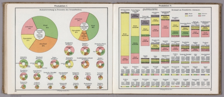
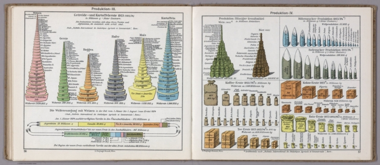
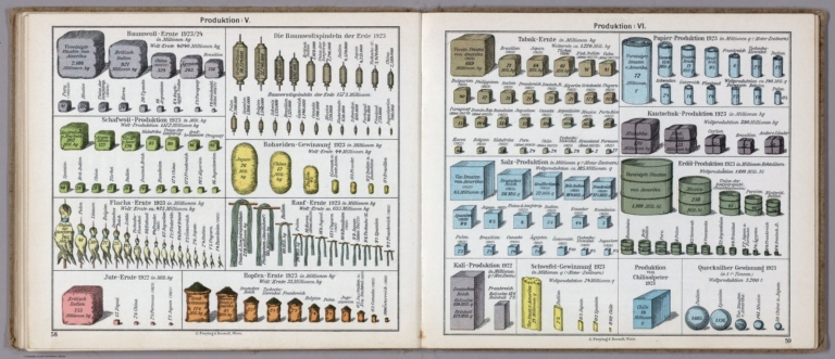


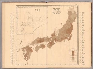


![19. EΛATTΩΣH KAΛΛIEPΓEIAΣ KAI MEΣHΣ ETHΣIAΣ ΓEΩPΓIKHΣ ΠAPAΓΩΓHΣ ...[Diminution of cultivation and of the average agricultural production].](https://www.davidrumsey.com/rumsey/Size2/RUMSEY~8~1/195/14295048.jpg)
![20. ETHΣIA ΓEΩPΓIKH ΠAPAΓΩΓH KATA THN KATOXH 1941-44 ...[Annual agricultural production during the Occupation 1941-44].](https://www.davidrumsey.com/rumsey/Size1/RUMSEY~8~1/195/14295050.jpg)