|
Author
[Gill, Leslie MacDonald, 1884-1947, Empire Marketing Board]
Full Title
England. The Crops & Live Stock ... Land ... Fisheries.
List No
10813.000
Author
[Gill, Leslie MacDonald, 1884-1947, Empire Marketing Board]
Full Title
A Map of Scotland Portraying Her Agricultural Products & Fisheries 1929.
List No
10778.000
Author
[Gill, Leslie MacDonald, 1884-1947, Empire Marketing Board]
Full Title
A Map of the Union of South Africa Portraying Her Agricultural Products & Fisheries.
List No
10779.000
Author
Andrews, RJ
Full Title
(Text page to) Cross-Sections Through California. Elevation and land cover data illustrated across 17 profiles and charts showing Valuable Crops, Sources of Electricity, Population Growth, In an Isotype Style. Copyright RJ Andrews 2020. All rights reserved.
List No
10537.002
Author
Andrews, RJ
Full Title
Cross-Sections Through California. 14x vertical exaggeration USGS elevations with symbols showing MLRC National Land Cover Database (2016) in an Isotype style. Copyright RJ Andrews 2020. All rights reserved.
List No
10537.003
Author
W. & A.K. Johnston
Full Title
Johnstons' map of Southern Russia. W. & A.K. Johnston, Engraver & Geographer to the Queen, Edinburgh. (to accompany) Johnstons' atlas of the war-1855. .
List No
8367.015
Note
Hand color map. Showing cattle rearing, and Grain producing districts, major cities, towns and villages, roads, tracks, churches, etc. Includes explanation and notes. Prime meridian is Greenwich.
Author
[Arutiunian, Aramais Bagratovich, Baghdasaryan, Andranik Bakhsii]
Full Title
Anasunner. (to accompany) Atlas Armi︠a︡nskoĭ Sovetskoĭ Sot︠s︡ialisticheskoĭ Respubliki. Erevan - Moskva 1961.
List No
13362.091
Note
Color map of Livestock, with 3 inset maps. Includes legend, graphs and charts. Relief shown by spot heights.
Author
Vuillemin, Alexandre
Full Title
Geographie commerciale et industrielle : Nouvelle carte illustree de l'Amerique du Nord : Indiquant Les Grandes Divisions Physiques, La Distribution Geographique Des Vegetaux Et Mineraux ... Dressee par A. Vuillemin. Gravee par Langevin. Paris, Chez Fatout, Editeur. 1861. Grave sur acier, Grave: la Topographie par Gerin, le trait au burin par F. Lefevre. Les illustrations dessinees par A. Testard et gravees par Guensu. Imprime par Mangeon. Paris. (to accompany) Atlas illustre de geographie commerciale et industrielle.
List No
13376.019
Note
Engraved outline hand color map. Including 16 vignettes views showing indigenous people in North America and 2 sections of fruits and plants in panels at sides. Map shows Russian America, Utah & New Mexico extending to the Rocky Mountains, Oregon, Northwest and Indian Territories, early discoveries, including a reference to Alvaro Nunez in Texas in 1528, Cabrillo's discovery of the Pacific in 1548, Francis Drake, Lewis & Clark and Edwin James. Includes legend, tables, color coded table of European colonies in the region and notes.
Author
Vuillemin, Alexandre
Full Title
Geographie commerciale et industrielle : Nouvelle carte illustree de l'Amerique du Sud : Indiquant Les Grandes Divisions Physiques, La Distribution Geographique Des Vegetaux Et Mineraux ... Dressee par A. Vuillemin. Gravee par Langevin. Paris, Chez Fatout, Editeur. 1861. Grave sur acier, Grave: la Topographie par Gerin, le trait au burin par F. Lefevre. Les illustrations dessinees par A. Testard et gravees par Guensu. Imprime par Mangeon. Paris. (to accompany) Atlas illustre de geographie commerciale et industrielle.
List No
13376.020
Note
Engraved outline hand color map. Inset: Carte donnant les parcours des bateaux a vapeur sur l'Atlantique el l'Océan Pacifique. Including 12 vignettes views of countries in South America and 2 sections of fruits and plants in panels at sides. Includes legend, tables and notes.
Author
Baur, Carl Friedrich
Full Title
Erdkarte. Entworfen u. gezeichnet v. C. F. Baur. Bassermann Verlagshandlung in Mannheim. (to accompany) Atlas fur Handel u. Industrie, fur Kaufleute, Fabrikanten u. Gewerbetreibende ... von C.F. Baur. 1857.
List No
13199.005
Note
Latest color map of the earth, showing political divisions, trade and European colonies. Includes explanation at the foot of map and color reference to European countries and colonies.
Author
Baur, Carl Friedrich
Full Title
Grossbritannien. Entworfen u. gezeichnet v. C. F. Baur. Bassermann' sche Verlagshandlung in Mannheim. (to accompany) Atlas fur Handel u. Industrie, fur Kaufleute, Fabrikanten u. Gewerbetreibende ... von C.F. Baur. 1857.
List No
13199.007
Note
Color map, with inset map of London. Shows major cities, roads, railroads, and shipping routes. Includes reference to agricultural, mineral and industrial products, and table of import and export.
Author
Baur, Carl Friedrich
Full Title
Frankreich. Entworfen u. gezeichnet v. C. F. Baur. Bassermann Verlagshandlung in Mannheim. (to accompany) Atlas fur Handel u. Industrie, fur Kaufleute, Fabrikanten u. Gewerbetreibende ... von C.F. Baur. 1857.
List No
13199.009
Note
Color map, with inset map of Umgebung von Paris. Shows major cities, roads, railroads, and shipping routes. Includes reference to agricultural, mineral and industrial products, and table of import and export.
Author
Baur, Carl Friedrich
Full Title
Vereinigte Staaten und Mexiko. Entworfen u. gezeichnet v. C. F. Baur. Bassermannsche Verlagshandlung in Mannheim. B. Walther lith. (to accompany) Atlas fur Handel u. Industrie, fur Kaufleute, Fabrikanten u. Gewerbetreibende ... von C.F. Baur. 1857.
List No
13199.049
Note
Color map. Includes color coded reference. Shows political and administrative boundaries, major cities, roads and shipping routes. Includes list of 24 States in Unite States and 20 Mexican States.
Author
Emery, Don J.
Full Title
A map of Florida for garden lovers. Published by the Garden Club of the Halifax Country Daytona Beach, Ormand & Ormand Beach. Copyright 1934. Designed by Don J. Emery- Daytona Beach.
List No
13212.002
Note
Pictorial map, bordered with decorative Art Deco illustrations of plants and bird species indigenous to Florida. Shows rich variety of flora, gardens, bird refuges, state parks, national forests, etc. Includes note describing the map, state and Garden Club seals. On verso: Text describing places of interest to lovers of both wild and cultivated gardens.
Author
[Vincey, Paul, France. Ministere de l'Agriculture]
Full Title
Carte agronomique des environs de Paris. Departement de la Seine. Dressee par order du Ministere de l'Agriculture. et du Prefet. de la Seine ... Par Mr. Paul Vincey. Chromolith. chez L. Wuhrer. Imp. Erhard, Paris. (to accompany) Album de statistique agricole et carte agronomique du departement de la Seine ... par M. Paul Vincey ... 1897. (inset) Profil geologique suivant A.B.
List No
13087.007
Note
Color folded agronomic map. Shows geologic formations, roads, railroads, place names and rivers. Includes descriptive text, charts and legends. Relief shown by contours and spot heights.
Author
[Vincey, Paul, France. Ministere de l'Agriculture]
Full Title
Departement de la Seine : Statistique agricole en 1894 : Repartition des cultures en grandes divisions. Grave chez L. Wuhrer; Ch. Labau del. (to accompany) Album de statistique agricole et carte agronomique du departement de la Seine ... par M. Paul Vincey ... 1897.
List No
13087.008
Note
Color statistical map. Includes descriptive text, statistical tables and key to cultivated area.
Author
[Vincey, Paul, France. Ministere de l'Agriculture]
Full Title
Departement de la Seine : Statistique agricole en 1894 : Redenment du froment par hectare du surface encemencee. Grave chez L. Wuhrer; Ch. Labau del. (to accompany) Album de statistique agricole et carte agronomique du departement de la Seine ... par M. Paul Vincey ... 1897.
List No
13087.012
Note
Color map of France. Includes descriptive text, and color coded key.
Author
[Vincey, Paul, France. Ministere de l'Agriculture]
Full Title
Departement de la Seine : Statistique agricole en 1893 : Repartition des animaix domestiques. Grave chez L. Wuhrer; Ch. Labau del. (to accompany) Album de statistique agricole et carte agronomique du departement de la Seine ... par M. Paul Vincey ... 1897.
List No
13087.018
Note
Color map of France. Includes statistical tables, text, and color coded key.
Author
France. Ministere de l'agriculture
Full Title
I. Percentage of the various areas making up the total territory of France par department en 1882. Imp. Clerc et Catineau - Paris. (in upper margin) Ministere de l'Agriculture. Album de statistique agricole,1887.
List No
13085.008
Note
Map showing percentage of the various areas making up the total territory of France. Insets: France; Seine; Algerie; Corse. Includes legend and color coded key.
Author
France. Ministere de l'agriculture
Full Title
II. Surface ensemencee en cereales par 100 hectares du territoire total en 1882. E' carts des moyennes departmentales par rapport a la moyenne generale. Imp. Clerc et Catineau - Paris. (in upper margin) Ministere de l'Agriculture. Album de statistique agricole,1887.
List No
13085.009
Note
Map showing of grain planting areas per 100 hactares of the total territory in 1882 and the departmental average in relation to the general average. Insets: Algerie; Corse. Includes legend and color coded key.
Author
[Silk, D. Wenaslin, Cavalcanti, Manoel Paulino, Sociedade Nacional de Agricultura (Brazil). Seccao de Geographia Agricola]
Full Title
Sociedade Nacional de Agricultura. Seccao Geographia Agricola : Grande premio na Expisicao Nacional de 1908. (Gradn prix a l'Exposicao Nacional 1908). Ensaio de mappa geologico do Brazil (Etude de carte geologique du Bresil). Visto, D. Wenaslin Silk. Organisado por M. Paulino Cavalcanti. Seccao Cartographica do Estabelecimento Graphico - Weiszflog, Irmaos - S. Paulo. (to accompany: Atlas do Brazil).
List No
11947.003
Note
Geological map of Brazil. Shows administrative divisions, rivers, forests and mountains. Relief shown by hachures. Includes legend.
Author
[Silk, D. Wenaslin, Cavalcanti, Manoel Paulino, Sociedade Nacional de Agricultura (Brazil). Seccao de Geographia Agricola]
Full Title
Sociedade Nacional de Agricultura. Seccao Geographia Agricola : Grande premio na Expisicao Nacional de 1908. (Gradn prix a l'Exposicao Nacional 1908). Ensaio de mappa agrologico do Brazil (Etude de carte agrologique du Bresil). Visto, D. Wenaslin Silk. Organisado por M. Paulino Cavalcanti. Seccao Cartographica do Estabelecimento Graphico - Weiszflog, Irmaos - S. Paulo. (to accompany: Atlas do Brazil).
List No
11947.004
Note
Agrological map of Brazil. Shows types of soil, administrative divisions, major cities, rivers, etc. Relief shown by hachures. Includes legend.
Author
[Silk, D. Wenaslin, Cavalcanti, Manoel Paulino, Sociedade Nacional de Agricultura (Brazil). Seccao de Geographia Agricola]
Full Title
Sociedade Nacional de Agricultura. Seccao Geographia Agricola : Grande premio na Expisicao Nacional de 1908. (Gradn prix a l'Exposicao Nacional 1908). Mappa demographico do Brazil (Carte demographique du Bresil). Visto, D. Wenaslin Silk. Organisado por M. Paulino Cavalcanti. Seccao Cartographica do Estabelecimento Graphico - Weiszflog, Irmaos - S. Paulo. (to accompany: Atlas do Brazil). (inset) America d Sul. Diagramma da populacao absouluta.
List No
11947.007
Note
Demographic map of Brazil, with diagram of the population of South America. Shows administrative divisions, major cities, rivers, forests and mountains. Relief shown by hachures. Includes legend.
Author
[Woodbridge, William C., Willard, Emma]
Full Title
(World) View of Climates and Productions; Drawn from the accounts of Humboldt, Mirbel, Buffon, and others.
List No
12497.013
Author
Gill, Leslie MacDonald, 1884-1947
Full Title
Map of Ceylon, showing her Tea & other industries.
List No
10047.000
Note
This is a larger version with different title and representation of the ocean compared to our smaller 12060.000
Author
Gill, Leslie MacDonald, 1884-1947
Full Title
Ceylon, her Tea and other industries.
List No
12060.000
Note
Date estimated.
Author
Gill, Leslie MacDonald, 1884-1947
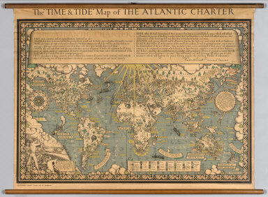
Full Title
The "Time & Tide" Map of The Atlantic Charter.
List No
7864.000
Note
At the head of the map is a lengthy quote from the Atlantic Charter, with the signatures of Franklin Roosevelt and Winston Churchill. The Atlantic Charter was a pivotal policy statement issued in August 1941 that, early in World War II, defined the Allied goals for the post-war world. It was drafted by the leaders of Britain and the United States, and later agreed to by all the Allies. Dramatic graphics with vignettes representative of various crops and resources. Statements espousing peace.
Author
Baker, Oliver Edwin
Full Title
Atlas of American Agriculture. Physical Basis including Land Relief, Climate, Soils, and Natural Vegetation of the United States. Prepared under the Supervision of O.E. Baker, Bureau of Agricultural Economics. Contributions from the Weather Bureau, Willis R. Gregg, Chief; Bureau of Chemistry and Soils, H.G. Knight, Chief; Bureau of Plant Industry, Frederick D. Richey, Chief; Forest Service, F.A. Silcox, Chief; Bureau of Agricultural Economics, A.G. Black, Chief. United States Department of Agriculture, Washington, D.C., United States Government Printing Office, Washington: 1936.
List No
5797.158
Note
This is the flip book reader version of the atlas.
Author
Andreas, A. T. (Alfred Theodore), 1839-1900
Full Title
Agricultural productions colored by grades to show quantity raised in localities. From the ninth census. Wheat, hay, corn, cotton, tobacco. (Published by the Andreas Atlas Co., Lakeside Building, Chicago, Ills. Engraved & printed by Chas. Shober & Co., Props. of Chicago Lithographing Co.)
List No
0018.018
Note
Five col. lithographed maps.
Author
[Andreas, A. T. (Alfred Theodore), 1839-1900, Baskin, Forster and Company]
Full Title
Agricultural productions colored by grades to show quantity raised in localities. From the ninth census. Wheat, hay, corn, cotton, tobacco. (Published by Baskin, Forster & Co. Lakeside Building Chicago, Ills. 1876. Engraved & Printed by Chas. Shober & Co. Props. of Chicago Lithographing Co.)
List No
0019.009
Note
Five col. lithographed maps.
Author
Cartee, Cornelius S.
Full Title
The distribution of trees, shrubs, grains & fruits. According to zones of climate & moisture. Designed To Accompany Cartee's "Elements Of Physical Geography. Engraved by G.W. Boynton. Entered ... 1856, by Hickling, Swan, And Brown ... Massachusetts. (to accompany) A School Atlas Of Physical Geography ... By Cornelius S. Cartee, A.M. M DCCC LVI. (inset) Distribution of plants in a vertical direction.
List No
0129.015
Note
Engraved hand color map. Color on the inset correspond with those on the map. Prime meridian is Greenwich.
Author
Johnston, Alexander Keith
Full Title
The Distribution of the Most Important Trees, Shrubs, Grains, & Fruits According to Zones of Climate & Moisture.
List No
0370.023
Note
Includes mountain profile.
Author
[Henfrey, Arthur, 1819-1859, Johnston, Alexander Keith, 1804-1871]
Full Title
Map of the geographical distribution of the most important plants yielding food, including the cultivated grains and other cultivated and wild bread plants with indications of the principal fruits; laid down in connection with climatal conditions for Keith Johnston's Physical atlas by Arthur Henfrey, F.R.S; F.L.S. &c. Engraved & printed in colours by W. & A.K. Johnston, Edinburgh. William Blackwood & Sons, Edinburgh & London. 1st. March 1854, (1856)
List No
0372.025
Note
Col. lithographed map. Insets: Map of the distribution of the principal food plants, fruits & characteristic trees of Western & Central Europe -- Map of the distribution of the more important plants, yielding materials for beverages, spices, dyes, and other economical substances; and growing in the warmer regions of the globe -- Map of the distribution of tea & the principal spices grown in the East Indies -- Two sections from S. to N. in Western & Central Europe, showing the distribution of the principal food plants according to altitude -- Two sections showing approximatively the distribution of the most important economical plants according to altitude, Western Hemisphere, Eastern Hemisphere. "Phytology & zoology no. 1."
Author
Henfrey, Arthur, 1819-1859
Full Title
On the Geographical Distribution of Plants Yielding Food.
List No
0372BN
Author
Henfrey, Arthur, 1819-1859
Full Title
On the Geographical Distribution of Plants Yielding Food. (continued)
List No
0372BO
Author
Larousse
Full Title
France Agricole et Industrielle.
List No
0418.051
Author
[Paullin, Charles O., Wright, John K.]
Full Title
Plate 142. Agriculture. Agricultural Regions, 1924. Cotton Production, 1839. Cotton Production, 1859. Cotton Production, 1889. Cotton Production, 1919. Cotton Production, 1924.
List No
0702.145
Author
[Paullin, Charles O., Wright, John K.]
Full Title
Plate 143. Agriculture. Cattle (Excluding Milch Cows), 1860. Cattle (Excluding Milch Cows), 1890. Cattle (Excluding Milch Cows), 1920. Cattle and Calves, 1925. Tobacco Production, 1839. Tobacco Production, 1859. Tobacco Production, 1889. Tobacco Production, 1919. Tobacco, Rice and Flax, 1924. Corn Production, 1839. Corn Production, 1859. Corn Production, 1889. Corn Production, 1919. Corn for Grain Production, 1924. Wheat Production, 1839. Wheat Production, 1859. Wheat Production, 1889. Wheat Production, 1919.
List No
0702.146
Author
[Paullin, Charles O., Wright, John K.]
Full Title
Plate 144. Agriculture. Spring Wheat Production, 1924. Winter Wheat Production, 1924. Improved Land, 1850. Improved Land, 1860. Improved Land, 1870. Improved Land, 1880. Improved Land, 1890. Improved Land, 1900.
List No
0702.147
Author
[Paullin, Charles O., Wright, John K.]
Full Title
Plate 145. Agriculture. Improved Land, 1910. Land in Harvested Crops, 1919. Land in Harvested Crops, 1929. Improved Land, 1850 - 1860. Improved Land, 1860 - 1870. Improved Land, 1880 - 1890. Improved Land, 1890 - 1900.
List No
0702.148
Author
[Paullin, Charles O., Wright, John K.]
Full Title
Plate 146. Agriculture. Improved Land, 1900 - 1910. Improved Land, 1910 - 1920. Land in Harvested Crops, 1909 - 1924. Improved Land, 1850 - 1860. Improved Land, 1860 - 1870. Improved Land, 1870 - 1880. Improved Land, 1880 - 1890. Improved Land, 1890 - 1900. Improved Land, 1900 - 1910. Land in Harvested Crops, 1909 - 1924. Land in Harvested Crops, 1924 - 1929. Tenant Farmers, 1880. Tenant Farmers, 1900. Tenant Farmers, 1920. Tenant Farmers, 1930.
List No
0702.149
Author
[Paullin, Charles O., Wright, John K.]
Full Title
Plate 147. Agriculture. Farm Lands and Buildings, 1850. Farm Lands and Buildings, 1880. Farm Lands and Buildings, 1910. Farm Lands and Buildings, 1930. Farm Implements and Machinery, 1850. Farm Implements and Machinery, 1880. Farm Implements and Machinery, 1910. Farm Implements and Machinery, 1930.
List No
0702.150
Author
Polish Army Topography Service
Full Title
Population. Pergamon World Atlas. Pergamon Press, Ltd. & P.W.N. Poland 1967. Sluzba Topograficzna W.P.
List No
0737.028
Note
Six maps of attributes of population: races, languages, growth, urbanization, and agricultural employment.
Author
Polish Army Topography Service
Full Title
Land Use. Pergamon World Atlas. Pergamon Press, Ltd. & P.W.N. Poland 1967. Sluzba Topograficzna W.P.
List No
0737.032
Note
Land use in six categories: arable, pasture, tropical grazing, some grazing, forest, and non-agricultural lands.
Author
Polish Army Topography Service
Full Title
Types of Agriculture. Pergamon World Atlas. Pergamon Press, Ltd. & P.W.N. Poland 1967. Sluzba Topograficzna W.P.
List No
0737.033
Note
Based on nineteen categories of agricultural land use.
Author
Polish Army Topography Service
Full Title
Agriculture. Pergamon World Atlas. Pergamon Press, Ltd. & P.W.N. Poland 1967. Sluzba Topograficzna W.P.
List No
0737.034
Note
Six agricultural maps: land and property ownership, farm size, artificial fertilizers and tractors, bread grains, rice, and barley and oats.
Author
Polish Army Topography Service
Full Title
Agriculture (continued). Pergamon World Atlas. Pergamon Press, Ltd. & P.W.N. Poland 1967. Sluzba Topograficzna W.P.
List No
0737.035
Note
Six agricultural maps: sucrose plants, oleaginous plants, fibros plants, viticulture and wine production, fruit growing, and stimulants and condiments.
Author
Polish Army Topography Service
Full Title
Agriculture (continued). Pergamon World Atlas. Pergamon Press, Ltd. & P.W.N. Poland 1967. Sluzba Topograficzna W.P.
List No
0737.036
Note
Six agricultural maps: tuberous plants, cattle, pigs, sheep and goats, draught and pack animals, and types of animal husbandry..
Author
Polish Army Topography Service
Full Title
Agriculture. Pergamon World Atlas. Pergamon Press, Ltd. & P.W.N. Poland 1967. Sluzba Topograficzna W.P.
List No
0737.037
Note
Three agricultural maps: forests, production of wood products, and fishing.
Author
Raisz, Erwin
Full Title
Agriculture. By Erwin Raisz. (index numbers) after D.S. Whittlesey. (to accompany) Atlas Of Global Geography. By Erwin Raisz. Lectures in Cartography, Institute Of Geographical Exploration, Harvard University, Cambridge, Mass. ... Global Press Corporation, Publishers. New York, N.Y. Sole Distributors: Harper & Brothers, New York. (on verso) Copyright 1944, by Global Press Corporation.
List No
0744.032
Note
Color maps. Accompanied by text, and reference charts. Relief shown pictorially. With paper dust jacket. On the jacket it states that this is an "entirely new kind of atlas - A beautiful and informative book of 'global' maps, giving a plane's-eye view of tomorrow's geography..."
|