Detail View: David Rumsey Historical Map Collection: Heights Of The Principal Mountains In The World.
|
Author:
|
Tanner, Henry S.
|
|
Date:
|
1845
|
|
Short Title:
|
Heights Of The Principal Mountains In The World.
|
|
Publisher:
|
Carey and Hart
|
|
Publisher Location:
|
Phila
|
|
Type:
|
Atlas Map
|
|
Obj Height cm:
|
32
|
|
Obj Width cm:
|
38
|
|
Scale 1:
|
37,000,000
|
|
Note:
|
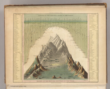
In full color with length of rivers shown opposite the mountains. List of heights by country given with corresponding number on mountain ranges. Engraved.
|
|
World Area:
|
World
|
|
Subject:
|
Mountains; Rivers
|
|
Subject:
|
Data Visualization
|
|
Full Title:
|
Heights Of The Principal Mountains In The World. F. Humphrys sculpt. Published by Carey & Hart, Philadelphia. Entered ... 1836, by H.S. Tanner ... Pennsylvania. (above neat line) Tanner's Universal Atlas.
|
|
List No:
|
5363.001
|
|
Page No:
|
72
|
|
Series No:
|
2
|
|
Publication Author:
|
Tanner, Henry S.
|
|
Pub Date:
|
1845
|
|
Pub Title:
|
A New Universal Atlas Containing Maps of the various Empires, Kingdoms, States and Republics Of The World. With a special map of each of the United States, Plans of Cities &c. Comprehended in seventy sheets and forming a series of One Hundred And Seventeen Maps, Plans And Sections, By H.S. Tanner ... Philadelphia, Published By Carey & Hart. 1844. Entered ... 1844, by Carey & Hart ... Pennsylvania. (title page by) J. Knight Sc.
|
|
Pub Note:
|
Mid 1845 edition, date on title page is 1844. The Texas map by C.S. Williams appears here for the only time in the engraved form. Full color.
|
|
Pub List No:
|
5363.000
|
|
Pub Type:
|
World Atlas
|
|
Pub Maps:
|
72
|
|
Pub Height cm:
|
46
|
|
Pub Width cm:
|
38
|
|
Image No:
|
5363001
|
|
Download 1:
|
|
|
Download 2:
|
|
|
Authors:
|
Tanner, Henry S.
|
|
Collection:
|
Rumsey Collection
|