COLLECTION NAME:
David Rumsey Historical Map Collection
Record
Author:
Humboldt, Alexander von, 1769-1859
Date:
1807
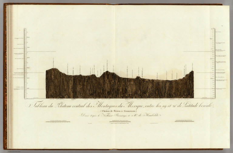
Short Title:
Tableau du Plateau central des Montagnes du Mexique.
Publisher:
F. Schoell
Publisher Location:
Paris
Type:
Atlas Map
Obj Height cm:
38
Obj Width cm:
82
Scale 1:
752,400
Note:
A cross section depicting the elevations from Mexico City to Guanaxuato. Geologic information is also included.
Reference:
Wheat 272-5; WC 7a:3a:1; Streeter Texas 1042n.
Country:
Mexico
City:
Mexico City (Mexico)
Full Title:
Tableau du Plateau central des Montagnes du Mexique, entre les 19 et 21¼ de Latitude boreale (Chemin de Mexico a Guanaxuato) Dresse d'apres le Nivellement Barometrique de Mr. de Humboldt. 14. Esquise par Alex. Mr. Humboldt a Mexico 1803. Dessine par Raphael Davalos a Mexico 1804 (termine a Berlin 1807). Grave par Bouquet. Les Echelles et l'Ecriture gravees par Aubert.
List No:
0328.014
Series No:
20
Engraver or Printer:
Aubert, L.
Engraver or Printer:
Bouquet
Engraver or Printer:
Davalos, Raphael
Publication Author:
Humboldt, Alexander von, 1769-1859
Pub Date:
1811
Pub Title:
Atlas Geographique Et Physique Du Royaume De La Nouvelle-Espagne, Fonde Sur Des Observations Astronomiques, Des Mesures Trigonometriques Et Des Nivellemens Barometriques. Par Al. De Humboldt. Paris, Chez F. Schoell, Rue Des Fosses-Saint-Germain-L'Auxerrois, No. 29. 1811. De L'Imprimerie De J.H. Stone.
Pub Reference:
Wheat 272-5; WC 7a:3a:1; Streeter Texas 1042n.
Pub Note:
First French edition (although some copies have 1808 on the title page). Stamp of Russian Imperial Library at Tsarkoe Selo. This atlas has the important "Carte Generale du Royaume de la Nouvelle Espagne" on two large folio sheets, originally drawn by Humboldt in 1803-4. Arrowsmith and Pike used this map as a base for their maps of Mexico and the southwest. Maps are without color and bound in full brown leather covered boards with "Voyage De Humboldt Et Bonplan. Atlas Geographique Et Physique Du Royaume De La Nouvelle-Espagne." stamped on the spine in black ink.
Pub List No:
0328.000
Pub Type:
National Atlas
Pub Maps:
16
Pub Height cm:
57
Pub Width cm:
42
Image No:
0328014
Authors:
Humboldt, Alexander von, 1769-1859
Collection:
Rumsey Collection