|
REFINE
Search Results: List_No equal to '0346.001' or List_No equal to '0346.002' or List_No equal to '0346.003' or List_No equal to '0346.004'
1-4 of 4
Author
Jefferys, Thomas
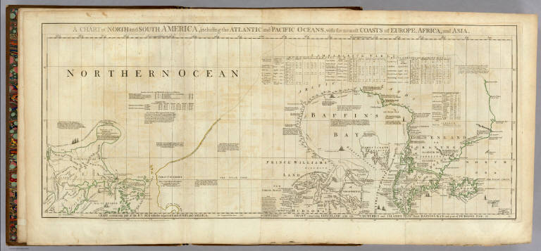
Full Title
A Chart of North and South America, including the Atlantic and Pacific Oceans, with the nearest Coasts of Europe, Africa, and Asia. Chart containing part of the Icy Sea with the adjacent Coast of Asia and America. Chart comprizing Greenland with the Countries and Islands about Baffins Bay and part of Hudsons Bay. Publish'd ... 10 June 1775, by Robt. Sayer & J. Bennett ... Fleet Street. No. II.
List No
0346.001
Note
In outline color. Map has extensive notes and charts noting variations in latitudes and longitudes noted by different observations.
Author
Jefferys, Thomas
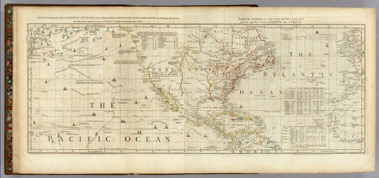
Full Title
Chart containing the Coasts of California, New Albion, and Russian Discoveries to the North, with the Peninsula of Kamtschatka, in Asia, opposite thereto; And Islands, dispersed over the Pacific Ocean, to the North of the Line. North America and The West Indies, with the opposite Coasts of Europe and Africa. Published ... 10 June 1775, by R. Sayer & J. Bennett ... Fleet Street. IV.
List No
0346.002
Note
In outline color. Map has extensive notes and charts noting variations in latitudes and longitudes noted by different observations. Tracks of the ships in the Pacific Ocean shown along with relevant dates.
Author
Jefferys, Thomas
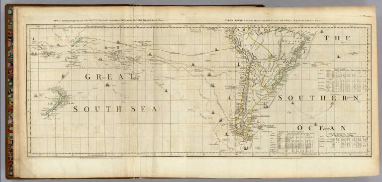
Full Title
Chart containing the greater part of the South Sea to the South of the Line, with the Islands dispersed thro' the same. South America with the adjacent Islands in the Southern Ocean and South Sea. Published ... 10 June 1775, by R. Sayer & J. Bennett ... Fleet Street. VI.
List No
0346.003
Note
In outline color. Map has extensive notes and charts noting variations in latitudes and longitudes noted by different observations. Tracks of the ships in the oceans shown along with relevant dates.
Author
Jefferys, Thomas
Full Title
(Composite of) A Chart of North and South America, including the Atlantic and Pacific Oceans ... (with) Chart containing the Coasts of California, New Albion, and Russian Discoveries to the North ... (with) Chart containing the greater part of the South Sea to the South of the Line ... Publish'd ... 10 June 1775, by Robt. Sayer & J. Bennett ... Fleet Street. No. II., IV., VI.
List No
0346.004
Note
Map has extensive notes and charts noting variations in latitudes and longitudes noted by different observations. Tracks of the ships in the oceans shown along with relevant dates. In outline color.
1-4 of 4
|