|
Author
Beechey, Frederick William
Full Title
The Harbour of San Francisco, Nueva California. (View) The Entrance to San Francisco Harbour. By Captn. F.W. Beechey ... 1827 & 8.
List No
12217.000
Note
Chart No. 591. From the Warren Heckrotte Auction catalog: "Very rare and important chart of San Francisco Bay, the result of the first scientific mapping of the Bay. Neil Harlow states that the chart "had a wide influence upon later maps of the area. The chart, with copies and adaptations of it, served to the end of the Mexican period and formed the substantial basis of the earliest ones produced under the American regime. It was deficient only in the region beyond Carquinez Strait..." Harlow notes the chart of the entrance contains "additional hydrographic data pertinent to entering the port and reaching the chief places of anchorage. Accompanying the chart are elevation views depicting the approaches to the bay and the hazards to navigation." No copies are listed in OCLC/WorldCat.."
Author
Duflot de Mofras, Eugene
Full Title
Port De San Francisco Dans La Haute Californie. No. 16. (with) Entree Du Port De San Francisco et des mouillages del Sausalito et de la Yerba Buena. Publie Par Arthus Bertrand. Grave par S. Jacobs. Voyage de Mr. Duflot de Mofras.
List No
4119.010
Note
Map of the San Francisco Bay region. Highly detailed.
Author
[Beechey, Frederick William, The California Herald]
Full Title
Plan of the harbour of San Francisco and its vicinity. By Captn. F. W. Beechy R. No. Published by James Gordon Bennett, New York Herald Office. 1949. The California Helarld. New York, Monday, January 1849. No. 2. Another view of California.
List No
11955.001
Note
Engraved broadside chart of the Harbour of San Francisco, the result of the first scientific mapping of the Bay. From the Monday, January 1849. No. 2. issue of the New York Herald. Shows some cities, ranchos and rivers. Relief shown by hachures. Depth shown by soundings. Includes compass rose oriented with the north to upper left. The text on the verso of the broadside discusses the recent discovery of gold and the emigrants flooding into the area.
Author
[Beechey, Frederick William, The California Herald]
Full Title
(Text Page to) Plan of the harbour of San Francisco and its vicinity. By Captn. F. W. Beechy R. No. Published by James Gordon Bennett, New York Herald Office. 1949. The California Helarld. New York, Monday, January 1849. No. 2. Another view of California.
List No
11955.002
Note
Engraved broadside chart of the Harbour of San Francisco, the result of the first scientific mapping of the Bay. From the Monday, January 1849. No. 2. issue of the New York Herald. Shows some cities, ranchos and rivers. Relief shown by hachures. Depth shown by soundings. Includes compass rose oriented with the north to upper left. The text on the verso of the broadside discusses the recent discovery of gold and the emigrants flooding into the area.
Author
Hartmann, Carl
Full Title
(Covers to) Die wichtigsten Hafen und Rheden, sowie die Goldregion von Californien. (with 10 maps:) Bai und Hafen von San Francisco. Der Hafen San Pedro. Das Stromgebiet des San Sacramento nebst den Goldlager-statten. Der Haven von San Francisco. Bai und Hafen von MonteRey. Mundungen der Flusse Colorado und Gila. Bai und Hafen von San Diego. Bai und Hafen von Santa Barbara. Der Hafen von la Paz und Bai von Pichilingue. Die Bai la Trinidad. Alfr. Hartmann, Architect, entworf. Zu Hartmanns zweiten Bericht uber Californien. Weimar, 1849. Verlag und Lithographie von B.F. Voigt.
List No
5470A
Note
Map, on heavy stock paper, folds to 22x14 with a blue label printed in black, "Dr. C. Hartmann's Specialkarte von Californien. enthaltend : 9 Kartchen von der Goldregion, sowie von den wichtigsten Hafen und Rheden. ... Weimar, Bernh. Fr. Voigt."
Author
Hartmann, Carl
Full Title
Die wichtigsten Hafen und Rheden, sowie die Goldregion von Californien. (with 10 maps:) Bai und Hafen von San Francisco. Der Hafen San Pedro. Das Stromgebiet des San Sacramento nebst den Goldlager-statten. Der Haven von San Francisco. Bai und Hafen von MonteRey. Mundungen der Flusse Colorado und Gila. Bai und Hafen von San Diego. Bai und Hafen von Santa Barbara. Der Hafen von la Paz und Bai von Pichilingue. Die Bai la Trinidad. Alfr. Hartmann, Architect, entworf. Zu Hartmanns zweiten Bericht uber Californien. Weimar, 1849. Verlag und Lithographie von B.F. Voigt.
List No
5470.001
Note
Map showing the bays, rivers, and Gold Region of California. Although uncolored, there is shading in the ocean, and hachures on the land. Soundings are given. Scale varies from map to map. Map, on heavy stock paper, folds to 22x14 with a blue label printed in black, "Dr. C. Hartmann's Specialkarte von Californien. enthaltend : 9 Kartchen von der Goldregion, sowie von den wichtigsten Hafen und Rheden. ... Weimar, Bernh. Fr. Voigt." Also appeared in: From: Hartmann, Carl. Geographisch-statistiche Beschreibung von Californien ... 1849.
Author
Sun Lithographic Establishment
Full Title
(Covers to) Map of The City Of San Francisco, California. Copied From Originals with Corrections and Additions. 1850. View of San Francisco in 1849. The Large Vessel At The Wharf is The "Apollo Store Ship."
List No
10423.001
Author
Sun Lithographic Establishment
Full Title
Map of The City Of San Francisco, California. Copied From Originals with Corrections and Additions. 1850. View of San Francisco in 1849. The Large Vessel At The Wharf is The "Apollo Store Ship."
List No
10423.002
Note
Gold Rush Historian James Delgado generously shared with us his knowledge of the background of this map: "Moses Yale Beach, the owner/publisher of the New York Sun, purchased Apollo for a speculative voyage to San Francisco in early 1849, and sent it off with a full load pf passengers and cargo, with son Joseph Perkins Beach as the ship’s supercargo, in charge of the business affairs. My book for the Book Club was the edited and annotated journal of the voyage kept by Joseph Perkins Beach. Apollo arrived on September 18, 1849; after the passengers and baggage were offloaded, Joseph, joined by his brother Henry Day Beach, who had come out separately, offered the cargo for sale with Apollo noted as lying off the foot of Sacramento Street. It moved slowly, and the crew deserted, so the Beach brothers decided to run Apollo up onto the mud and turn it into a storeship, as suggested by Moses Beach and also perhaps inspired by Niantic, a July 1849 arrival beached at the foot of Clay (at what is now Clay and Sansome) just as Apollo arrived. The Beach brothers paid $200 to run the ship ashore at the foot of Sacramento on waterlot #171, and there, dismasted, and emptied of ballast, facing west with the stern close to what would become Battery street, Apollo was readied for storeship use. A January 2, 1850 advertisement called for carpenters and wharfing work, and soon the decks were covered by a two-story building that conformed to the shape of the ship. Sixteen days later, they advertised Apollo was ready to “receive goods upon moderate rates of storage.” The Sun Lithographic Establishment, owned by Moses Yale Beach back in New York, published a broadside of the ship advertising it with its “uncommon advantages for storage of all descriptions.” The map just published is clearly another business booster prepared by Papa for his boys (and the family investment). Unfortunately for the Beach’s, the business faltered. Advertisements in the San Francisco Daily Alta California paint a picture of increased desperation, as does private correspondence between the brothers and the folks back in New York. Henry Day beach wrote home in January 1850, noting that “the way I worked and toiled on the Apollo property (I know it has shortened by life 5 years) has effectively cured me of speculation in this country.” The brothers leased the storeship to a firm, Reese & Blakely, in August 1850, but there were dozens of competing storeships. That makes the map all the more interesting, because looking at it, potential investors back east would think there was only one, the centrally located, accessible Apollo. Unless you went, you wouldn’t know of the other ships or of the crowded waterfront that hemmed in Apollo. Hope of recouping the investment vanished when Apollo, along with much of the rest of the city and the waterfront, burned to the ground in the May 4, 1851 fire that devastated the city.
The burned out remains of Apollo were encountered by construction excavation in 1901, 1921 and 1925, and portions of it remain beneath the former Federal Reserve Bank at Sacramento and Battery. Every time I’m in town and walk by, I silently salute Apollo, as well as the buried bones of the storeships Niantic, General Harrison and Thomas Bennett that lie close by. THANK You for finding and presenting this map."
Author
[Eddy, William M., Jones, William Carey]
Full Title
(Title Page to) Report of the Secretary of the Interior, Communicating A Copy of the report of William Carey Jones, special agent to examine the subject of land titles in California. ... January 30, 1851. Ordered to be printed. [Senate.] 31st Congress, 1st Session. Ex. Doc. No. 18. (With) Eddy's Official Map of San Francisco ... 1849.
List No
2321A
Author
[Eddy, William M., Jones, William Carey]
Full Title
Official Map of San Francisco, Compiled from the Field Notes of the Official Re-Survey made by William M. Eddy. Surveyor of the Town of San Francisco, California. 1849. S.W. Higgins. Draftn. Copied by P.M. McGill C.E. & Draftn. Washington. C.B. Graham lith. Washington, D.C.
List No
2321.001
Note
Map is without color except for three small sections that show a grant to Senora Briones, the claim of the heirs of Col. J.A. King, and the claim of Senor Pana under a Mexican grant.
Author
Eddy, William, M.
Full Title
Official map of the City of San Francisco, Full and complete to the present date. Compiled by Wm., M. Eddy. City Surveyor. January 15th. 1851. Engraved by Edwin Moody. John B Brady delr. B.F. Butler's Lith., Clay St. San Francisco.
List No
5870.000
Note
Map printed without color. With red lines added by hand. Outer red line is water front. Inner red line is shore line. Shows block and lot numbers, and wards. Note on the lower corner reads: E.M. Sleator, Canvassing Agent, 529 Shotwell St., San Francisco, Map coloring neatly done.
Author
Eddy, William Marston
Full Title
A Topographical & Complete Map of San Francisco. Compiled from the Original Map, from the recent Surveys of W.M. Eddy, County Surveyor, and Others.
List No
12216.000
Note
Important early map of San Francisco during the early days of the gold rush.
Author
Britton & Rey
Full Title
Map of San Francisco, Compiled from latest Surveys & containing all late extensions & Division of Wards. Published By Britton & Rey, San Francisco Cal.
List No
4333.000
Note
Letter sheet map showing the "Lately planket (sic) Streets" and the original shoreline. Streeter estimates the date by comparison with the Butler and Zakreski maps, which are earlier and later, respectively. With a vignette of an untitled building in the lower right corner. This copy was owned by the noted San Francisco collector Dr. Alexander Thomas Leonard, with his signature and notes on the verso of the board the map is mounted on. According to Sally Woodbridge the firm of of Page, Bacon & Co., which owned the building in the lower right corner was at the top of the banking heap in 1852; it was est. in 1849 as a branch of a St. Louis bank. In the financial panic of 1855 it suffered a disastrous run and was ruined along with many other banks.
Author
[Dougal, William H., 1822-1895, Ringgold, Cadwalader, 1802-1867]
Full Title
View of San Francisco from Yerba Buena Island. W.H. Dougal. (Washington: printed by Jno. T. Towers, 1852)
List No
4658.002
Note
Col. lithograph.
Author
United States Coast Survey
Full Title
U.S. Coast Survey A.D. Bache, Superintendent, City Of San Francisco And Its Vicinity California. From a Trigonometrical Survey by R.D. Cutts, Assistant. Topography by A.F. Rodgers Sub-assistant. Hydrography by the Party under the command of Lieut. James Alden U.S.N. Asst. 1853. U.S. Coast Survey Office. Price 50 Cents. Verified I.I. Stevens ... No. 627. Outlines and Topography engraved by Max. F.O. Strobel; Lettering by E.F. Woodward.
List No
3463.000
Note
Vogdes shows this as the first edition. Vogdes says that the survey was completed in April, 1852, and that the interior topography was taken from Eddy's official map of the city. We have a reproduction of an earlier state of the chart which has no soundings and is dated 1852; it says the plan of the city was taken from the map by Cooke and Le Count; there are differences in the piers and the buildings along the piers. We can find no reference for this earlier state. In the Annual Report of the Survey for 1853, another issue of the chart was published (litho) with the addition of more notes regarding tides in the upper left - this same chart was also issued (engraved on thin paper) in the collection of charts published by the survey in 1854. Map is without color.
Author
United States Coast Survey
Full Title
U.S. Coast Survey A.D. Bache, Superintendent. City Of San Francisco And Its Vicinity California. Topography by A.F. Rodgers, Sub-assistant. Hydrography by the Party under the command of Lieut. James Alden. Published in 1853. Outline and topography engraved by Max. F. O. Strobel. Lettering by E.F. Woodward.
List No
11890.000
Note
Uncolored map of city of San Francisco extends south to the Mission de Dolores and Pt. San Quentin. Shows streets, city blocks, drainage, public reservoirs, wharfs and many public buildings named and marked, Relief shown by contours and spot heights. Depth shown by bathymetric soundings. Includes explanatory text and notes. At upper right margin: Electrotype copy No. 1 by G. Mathiot. This is a slight variation on other issues of this chart.
Author
Bache, A. D.
Full Title
U.S. Coast Survey A.D. Bache, Superintendent, city of San Francisco and its vicinity, California. From a trigonometrical survey by R.D. Cutts, assistant. Topography by A.F. Rodgers sub-assistant. Hydrography by the party under the command of Lieut. James Alden U.S.N. Asst. 1853. U.S. Coast Survey Office. Verified I.I. Stevens ... Outlines and Topography engraved by Max. F.O. Strobel; Lettering by E.F. Woodward. Electrotype copy no. 1 by G. Mathiot, U.S.C.S.
List No
2470.053
Note
Vogdes shows this as the first edition. Map is without color. Relief shown by hachures; depths by soundings. Shows buildings, etc. In upper margin "Presented under authority of an act of Congress of the United States of June 3d 1844 by direction of the Treasury Department, A.D. Bache Superintendent Coast Survey."
Author
Lange, Henry, 1821-1893.
Full Title
Bai San Francisco und Vereinigung des Sacramento mit dem San Joaquin. (with view) San Francisco. H. Lange's Atlas v. Nord Amerika Blatt XVIII. Braunschweig: Verlag v. George Westermann. Lith. Anst. von L. Kraatz in Berlin.
List No
2743.018
Note
Engraved map. Hand col. Table of distances from San Francisco in English and German. Relief shown by hachures and spot heights; depths by soundings.
Author
[United States Coast Survey, Rodgers, A.F.]
Full Title
U.S. Coast Survey A.D. Bache, Superintendent. City Of San Francisco And Its Vicinity California. From a plane label survey by A.F. Rogers Sub-assistant. Verified W.R. Palmer Capt. Topl. Engrs. Asst. C.S. In charge of Office. Lith. of J. Bien 60 Fulton St. N.Y.
List No
6811.000
Note
Rare first edition of the U.S. Coast Survey map of the City of San Francisco and vicinity. Printed without color. Relief shown by contours and spot heights. Includes note and table of reference to public buildings. 1857 edition marked a significant improvement in the USCS's mapping of San Francisco. Prepared by A.F. Rogers, it captured the tremendous growth of the City, locating wharves, streets, buildings, roads, topographical features and places such as the Union Race Course and Pioneer Race Course, west of the City. While first issued and corrected in 1857, neither of the 1857 editions was never published in the regular annual Coast Survey reports until a revised edition, dated 1859, was issued. This chart was first issued in 1857, with another edition issued later in 1857 that differs from the earlier edition and is apparently the same as 1859 edition see our 1030). The first edition does not include soundings, has a shorter "note" in the top right corner, and does not include the "Blosom rock Buoy" which appears below the table. It also does not include the "hydrography by Lieut. R.M. Cuyler". OCLC locates only 3 copies of this 1857 edition at San Francisco National Maritime Museum, University of Wisconsin, Milwaukee, and the British Library.
Author
[Johnston, Alexander Keith, 1804-1871, Rogers, Henry Darwin]
Full Title
New Orleans. San Francisco. London ... & according to an act of Congress ... 1857, by H.D. Rogers ... Massachusetts. London, John Murray, Albemarle Street, Edinburgh, W. & A.K. Johnston. Engraved by W. & A.K. Johnston, Edinburgh.
List No
3825.030
Note
Full color in water sections, cities with no color.
Author
Anonymous
Full Title
(Composite of) Sections I-V. (Map of Western Addition, San Francisco, Land Claims.)
List No
12110.006
Note
The three Van Ness Ordinances of 1856 to 1858 resulted in the creation and mapping of the Western Addition neighborhood of San Francisco. These five manuscript maps were likely made to show the existing land claims in relation to the newly platted streets, parks, and other public spaces. They may have been used in the subsequent resolution of the various land claims. They show many interesting artifacts of the early settlement of the area before it was officially made a part of the city in the mid 1850's. The 1858 date of the five maps is estimated, based on the creation of the Van Ness map in the same year. Part of the Mission district is also covered.
Author
Anonymous
Full Title
Section I. (Map of Western Addition, San Francisco, Land Claims.)
List No
12110.001
Note
The three Van Ness Ordinances of 1856 to 1858 resulted in the creation and mapping of the Western Addition neighborhood of San Francisco. These five manuscript maps were likely made to show the existing land claims in relation to the newly platted streets, parks, and other public spaces. They may have been used in the subsequent resolution of the various land claims. They show many interesting artifacts of the early settlement of the area before it was officially made a part of the city in the mid 1850's. The 1858 date of the five maps is estimated, based on the creation of the Van Ness map in the same year. Part of the Mission district is also covered.
Author
Anonymous
Full Title
Section II. (Map of Western Addition, San Francisco, Land Claims.)
List No
12110.002
Note
The three Van Ness Ordinances of 1856 to 1858 resulted in the creation and mapping of the Western Addition neighborhood of San Francisco. These five manuscript maps were likely made to show the existing land claims in relation to the newly platted streets, parks, and other public spaces. They may have been used in the subsequent resolution of the various land claims. They show many interesting artifacts of the early settlement of the area before it was officially made a part of the city in the mid 1850's. The 1858 date of the five maps is estimated, based on the creation of the Van Ness map in the same year. Part of the Mission district is also covered.
Author
Anonymous
Full Title
Section III. (Map of Western Addition, San Francisco, Land Claims.)
List No
12110.003
Note
The three Van Ness Ordinances of 1856 to 1858 resulted in the creation and mapping of the Western Addition neighborhood of San Francisco. These five manuscript maps were likely made to show the existing land claims in relation to the newly platted streets, parks, and other public spaces. They may have been used in the subsequent resolution of the various land claims. They show many interesting artifacts of the early settlement of the area before it was officially made a part of the city in the mid 1850's. The 1858 date of the five maps is estimated, based on the creation of the Van Ness map in the same year. Part of the Mission district is also covered.
Author
Anonymous
Full Title
Section IV. (Map of Western Addition, San Francisco, Land Claims.)
List No
12110.004
Note
The three Van Ness Ordinances of 1856 to 1858 resulted in the creation and mapping of the Western Addition neighborhood of San Francisco. These five manuscript maps were likely made to show the existing land claims in relation to the newly platted streets, parks, and other public spaces. They may have been used in the subsequent resolution of the various land claims. They show many interesting artifacts of the early settlement of the area before it was officially made a part of the city in the mid 1850's. The 1858 date of the five maps is estimated, based on the creation of the Van Ness map in the same year. Part of the Mission district is also covered.
Author
Anonymous
Full Title
Section V. (Map of Western Addition, San Francisco, Land Claims.)
List No
12110.005
Note
The three Van Ness Ordinances of 1856 to 1858 resulted in the creation and mapping of the Western Addition neighborhood of San Francisco. These five manuscript maps were likely made to show the existing land claims in relation to the newly platted streets, parks, and other public spaces. They may have been used in the subsequent resolution of the various land claims. They show many interesting artifacts of the early settlement of the area before it was officially made a part of the city in the mid 1850's. The 1858 date of the five maps is estimated, based on the creation of the Van Ness map in the same year. Part of the Mission district is also covered.
Author
United States Coast Survey
Full Title
U.S. Coast Survey A.D. Bache, Superintendent. City Of San Francisco And Its Vicinity California. Topography by A.F. Rodgers, Sub-assistant. Hydrography by the Party under the command of Lieut. R.M. Cuyler N.S.N. Assistant. Published in 1859. U.S. Coast Survey Office. Price 40 cents. Verified W.R. Palmer Capt. Topl. Engrs. Asst. C.S. In charge of Office. Lith. of J. Bien 60 Fulton St. N.Y.
List No
1030.000
Note
Heavy paper chart; uses contours. First issued in 1857, with another edition issued later in 1857 that differs from the earlier 1857 edition and is apparently the same as this 1859 edition (Vogdes). Without color. Map is bordered in blue silk, dissected into 8 sections, and folds into a new mauve cloth folding case with "U.S. Coast Survey San Francisco 1859" stamped in gilt on the spine.
Author
United States Coast Survey
Full Title
Entrance to San Francisco Bay California. From a Trigonometrical Survey under the direction of A.D. Bache Superintendent of the Survey Of The Coast Of The United States. Triangulation by R.D. Cutts Asst. & A.F. Rodgers Sub-Assts. Hydrography by the Party under the command of Lieut. Comdg. James Alden U.S.N. Asst. 1859. U.S. Coast Survey Office. Verified W.R. Palmer ... No. 36. Redd. Drng. by W.M.C. Fairfax, J. Lambert, & J.J. Ricketts. Engd. by J. Knight, A. Blondeau & G.B. Metzeroth. Electrotype Copy No. 2 by G. Mathiot U.S.C.S. (inset map) Sub-Sketch Of Entrance To San Francisco Bay. 1859.).
List No
1032.000
Note
Light paper chart-full margins, shows plate marks. Map is without color.
Author
Petri, Girolamo
Full Title
Tav. CXXXI. Province ecclesiastiche di Oregon e di S. Francesco, vicariato aplico della Nebraska.
List No
14007.319
Note
Hand-colored, engraved map showing the ecclesiastical provinces of Oregon, San Francisco (California), as well as the apostolic vicariates of Nebraska. Text in delicate script circling land. Accompanied by descriptive text on facing page. In Volume III.
Author
[Colton, G.W., Fisher, Richard Swainson]
Full Title
Oregon, Washington, California, Utah, and New Mexico. (inset) Vicinity of San Francisco.
List No
1690.121
Note
Relief depicted by hachures.
Author
Lecount, Josiah J.
Full Title
Official Map Of The City Of San Francisco, California. Published by Josiah J. Lecount, Manufacturer & Importer Of Stationery & Miscellaneous Books, Montgomery St., San Francisco. Approved By Geo. R. Turner, City & County Surveyor, 1859. Lithy. Of Britton & Co. S.F.
List No
2543.000
Note
Early map of the city. Says "Approved by Geo. R. Turner, City & County Surveyor." Shows division of lots, shoreline. Map is without color.
Author
Lecount, Josiah J.
Full Title
Official Map Of The City Of San Francisco, California. Published by Josiah J. Lecount, Manufacturer & Importer Of Stationery & Miscellaneous Books, Montgomery St., San Francisco. Approved By Geo. R. Turner, City & County Surveyor, 1859. Lithy. Of Britton & Co. S.F.
List No
5873.000
Note
Wall map version of our 2543.000. Early map of the city. Says "Approved by Geo. R. Turner, City & County Surveyor." Shows division of lots, shoreline. Map is without color.
Author
Vincent
Full Title
Map Of The State Of California. Compiled from the most recent surveys and explorations Containing all the latest discoveries and newest towns. By Vincent. Printed by Mangeon S. Jacques St. Engraved by Ch. Smith. (inset) San Francisco and its surrounding localities. 1860.
List No
1124.000
Note
Unusual map showing California on its side with north to the left, an inset map and a beautiful view titled "Panorama Of San Francisco and Contra Costa." Full color by county.
Author
Mitchell, Samuel Augustus
Full Title
County Map Of California. 37. (with) two inset maps: Map Of The Settlements in the Great Salt Lake Country. Utah. 38. San Francisco Bay and Vicinity. 39. Entered ... 1860, by S. Augustus Mitchell, Jr. ... Pennsylvania.
List No
0565.027
Note
In full color by county.
Author
City Land Association
Full Title
Map of the Property of the City Land Association, Incorporated under the Laws of the State of California.
List No
12386.000
Note
Date estimated.
Author
[Britton & Co., Hoadley, Milo]
Full Title
Map of the Beideman Tract lots & blocks according to official map of the Western Addition. Drawn from actual survey by M. Hoadley. ... Lith. Britton & Co. To be sold at public auction, on Saturday, Oct. 6th, 1860 at 12 o'clock M. at Platts Music Hall. By H.A. Cobb and R.H. Sinton, real estate auctrs. (with) Map of the city of San Francisco. Published by Britton & Co., Lithographers, Montgomery St. cor. of Comml. sts., San Francisco.
List No
4780.000
Note
Scarce and early land sale map with a very early issue of Britton & Co.'s "Map of the City of San Francisco" and below it on the same sheet a larger "Map of the Beideman Tract..." Beideman owned several large parcels of land in the emerging areas of the city and this tract was one of the earliest to be sold in the newly annexed Western Addition. The Britton & Co. Map of San Francisco is the earliest issue that we have seen, followed by several issues in 1863 to 1867 by Gensoul and the San Francisco Municipal Reports and the San Francisco Directory (see our copies under Gensoul). The Norris catalog lists an 1859 Map of Hayes Tract also by M. Hoadley with lots to be sold at auction by H.A. Cobb, but the San Francisco map is not printed above the Hayes Tract map. One of the earliest San Francisco land sales maps. Covers area bounded by Laguna, Bush, Larkin and McAllister streets. Casastral map.
Author
[Langley, Henry G., Wackenreuder, V.]
Full Title
City And County Of San Francisco. Compiled From Official Surveys And Sectionalized In Accordance With U.S. Surveys. Drawn By V. Wackenreuder, C.E. 1861. Published By Henry G. Langley For the San Francisco Directory. Entered ... 1861 By Henry G. Langley ... California. Britton & Co. Print. (with 3 inset maps of the Farrallon Islands).
List No
3867.000
Note
First map of the city to be included in Langley's directory. Early map to show the western and southern parts of the peninsula, with the land grants, and full topography. Also shows the northern part of San Mateo County and a small part of Marin County. Three insets show the Farrallon Islands. Directory not present. Map is without color.
Author
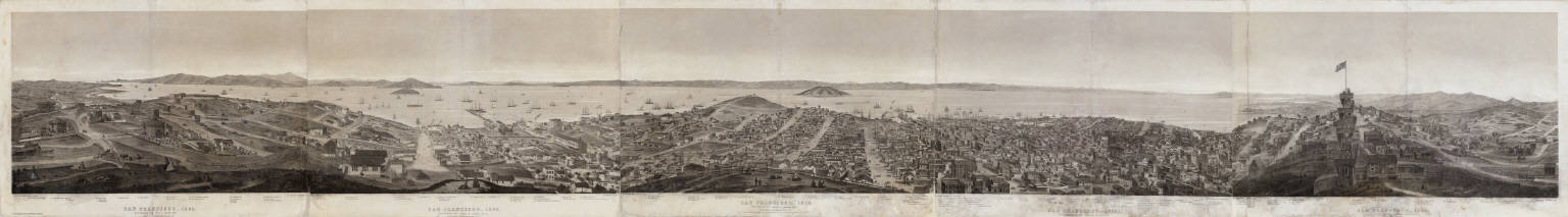
[Gifford, C. B. (Charles B.), Nagel, L. (Louis)]
Full Title
(Covers to) San Francisco, 1862. From Russian Hill. C.B. Gifford, del. et lith. Printed by L. Nagel, S.F. Published by A. Rosenfield, S.F. Entered according to Act of Congress in the year 1862 by A. Rosenfield ... Northern District of California. (label) Panoramic view of San Francisco.
List No
5147A
Note
A five sheet, nine foot, panoramic 360 degree view of early San Francisco from the top of Russian Hill. First edition. Reps calls this "Gifford's finest and most ambitious view" and Peters refers to it as "This important and rare panorama." It was issued in three forms: on thin paper mounted on cloth and folded into an album with covers, on heavy paper as five separate sheets, and on heavy paper backed with linen and attached to wooden rollers (wall map style). This copy is the first form, but without the album. There are 125 numbered references in the lower margin identifying buildings, etc. Printed by L. Nagel. There was a second edition in 1863. This copy originally had the five sheets joined and folded into covers, with the original blue title label on the verso of the first sheet.
Author
[Gifford, C. B. (Charles B.), Nagel, L. (Louis)]
Full Title
San Francisco, 1862. From Russian Hill. C.B. Gifford, del. et lith. Printed by L. Nagel, S.F. Published by A. Rosenfield, S.F. Entered according to Act of Congress in the year 1862 by A. Rosenfield ... Northern District of California. (label) Panoramic view of San Francisco.
List No
5147.001
Note
A five sheet, nine foot, panoramic 360 degree view of early San Francisco from the top of Russian Hill. First edition. Reps calls this "Gifford's finest and most ambitious view" and Peters refers to it as "This important and rare panorama." It was issued in three forms: on thin paper mounted on cloth and folded into an album with covers, on heavy paper as five separate sheets, and on heavy paper backed with linen and attached to wooden rollers (wall map style). This copy is the first form, but without the album. There are 125 numbered references in the lower margin identifying buildings, etc. Printed by L. Nagel. There was a second edition in 1863. This copy originally had the five sheets joined and folded into covers, with the original blue title label on the verso of the first sheet.
Author
[British Admiralty, Alden, James]
Full Title
N. America West Coast. San Francisco Harbour Surveyed by Lieut. James Alden U.S. Navy 1856. London. Published at the Admiralty 20th. Oct. 1860, under the Superintendence of Captn. Washington, R.N., F.R.S. Hydrographer. Corrections to Augt. 63 ... Engraved by J. & C. Walker. (with 4 profile views). (on lower right margin) 591.
List No
6860.000
Note
Large format British Admiralty chart of West Coast of the United States. Showing San Francisco Bay, extending to Drake Bay, Vallejo, Petaluma Creek, and Oakland, as surveyed by James Alden of the U.S. Coast Survey and the British shortly after the discovery of Gold in California. Shows inland detail identifying roads, landings, buildings, and detailed street grid in major cities. Includes topographic features. Relief shown by hachures and spot heights in feet. Depth shown by soundings in Fathoms. Includes text, notes, and 3 rhumb lines pointing to the north.
Author
Gensoul, A.
Full Title
(Covers to) Railroad Map Of The City Of San Francisco California. A. Gensoul Bookseller and Stationer. 511 Montgomery St. San Francisco. Lith. Britton & Co. S.F.
List No
3187.001
Note
Norris: "Very scarce railroad map of San Francisco." Streeter purchased the Norris copy, which was not in as good condition as this copy. Not in any of the standard references. Red circles emanate from City Hall showing distances at 1/4 mile intervals. Four railroads are identified. The map goes west to Divisadero and south to Alta Street. On the inside front cover is an ad for the Pacific Map Depot, A. Gensoul, 511 Montgomery Street. Various maps, including Mining maps are listed for sale. The front of the dark green cloth covers 9.5x8 have a printed purple label "Railroad Pocket Map Of The City Of San Francisco. Pacific Map Depot. San Francisco, Cal." A later issue was published in 1866 by Gensoul; a similar map was used in various editions of the San Francisco Municipal Reports in the 1860's.
Author
Gensoul, A.
Full Title
Railroad Map Of The City Of San Francisco California. A. Gensoul Bookseller and Stationer. 511 Montgomery St. San Francisco. Lith. Britton & Co. S.F.
List No
3187.002
Note
Norris: "Very scarce railroad map of San Francisco." Streeter purchased the Norris copy, which was not in as good condition as this copy. Not in any of the standard references. Red circles emanate from City Hall showing distances at 1/4 mile intervals. Four railroads are identified. The map goes west to Divisadero and south to Alta Street. On the inside front cover is an ad for the Pacific Map Depot, A. Gensoul, 511 Montgomery Street. Various maps, including Mining maps are listed for sale. The front of the dark green cloth covers 9.5x8 have a printed purple label "Railroad Pocket Map Of The City Of San Francisco. Pacific Map Depot. San Francisco, Cal." A later issue was published in 1866 by Gensoul; a similar map was used in various editions of the San Francisco Municipal Reports in the 1860's.
Author
Butler, James
Full Title
Map of the City and County of San Francisco: carefully compiled from recent surveys ... Drawn for the San Francisco News Letter and the Pacific Mining Journal. By James Butler 1864. Approved by Gillespie & Gray, searcher of records and Leander Ransome, U.S. Locating agent. Lith. Brtton (Briton) & Co., S.F. Entered according to Act of Congress in the year 1863 ... California.
List No
11809.000
Note
Detailed map of City and county of San Francisco, mounted on linen. Showing land ownership, block numbers, city boundaries 1850-1863, tract names, ranchos, section lines, roads, railroads, parks, etc. Includes legend and list of landowners.
Author
[Britton & Co., Gensoul, A.]
Full Title
Railroad Map Of The City Of San Francisco California. Printed For The San Francisco Directory By Britton & Co. 1864. Lith. Britton & Co. S.F.
List No
4779.000
Note
Color map. Another version of the Gensoul/Briton map of 1863, this time issued for either Langley's San Francisco Directory of 1864 or B.F. Stilwell's San Francisco Business Directory 1864-65 (book not present) - see Rocq 7988 and 7990. Brown circles emanate from Centre Portsmouth Square showing distances at 1/4 mile intervals. Includes Reference.
Author
[Gifford, C. B. (Charles B.), Nagel, L. (Louis)]
Full Title
Lone Mountain Cemetery. San Francisco.
List No
15448.000
Author
Gensoul, A.
Full Title
Railroad Map Of The City Of San Francisco California. Published By A. Gensoul Pacific Map Depot 511 Montgomery St. S. Franco. 1866. Lith. Britton & Co. S.F.
List No
4655.000
Note
Color map. This is a later edition of Gensoul's map of 1863. The Mission Bay Bridge is added. Otherwise we can detect no changes. It may have been published with the San Francisco Municipal Report for 1866. Brown circles emanate from Centre Portsmouth Square showing distances at 1/4 mile intervals. Includes Reference.
Author
[Hoffmann, Charles F., Whitney, J.D., Geological Survey of California]
Full Title
Map Of The Region Adjacent To The Bay Of San Francisco. State Geological Survey Of California, J.D. Whitney, State Geologist. W. H. Brewer, W. M. Gabb, and A. Rémond, Assistants. C.F. Hoffman, Topographer. The Coast, Rancho, Township and Section Lines from Materials furnished by the U.S. Coast Survey and the U.S. Surveyor General's Office, the Topography chiefly from Original Surveys by C.F. Hoffman ... 1867. Engraved by Julius Bien, N.Y.
List No
5817.000
Note
The first edition of this map, see our second edition of 1873, 5806.000. Many changes and updates occur in the 1873 edition. This was mounted as a wall map. It was used in c. 1887 court case for which a "Lewis Survey" of part of Las Positas Rancho was outlined in red (this is present on the map but faint in lettering and outline). Outline color.
Author
Snow & Roos
Full Title
Birds eye view of the city of San Francisco. Published by Snow & Roos, San Francisco. Steam Litho. Britton & Rey, S.F. Entered according to act of Congress ... 1868, by Snow & Roos in the Clerk's office in district court of northern district of California.
List No
13234.000
Note
Color lithograph early view of San Francisco from the southeast looking out towards the Pacific Ocean, showing the continuous rows of business blocks lining the streets west of Yerba Buena Cove, and sailing ships and a few steam vessels, with the wharves, piers in waterfront. Relief shown by shadings. The view immediately pre-dates the development of Golden Gate Park.
Author
[Newport, California, Smith, W. Alpheus]
Full Title
California Map Showing San Francisco, Newport. And Rail Road Connections With The Adjacent Country. Drawn by W. Alpheus Smith. T.R. Holland Lith. Boston. Plan & Location of the City of Newport, California, the terminus of the Great Pacific Rail-Road, a few homestead & building lots to be distributed free. for particulars enquire of the Agnet. (inset) Plan of Newport, California. (with: A Deed for lot 37 in Block 392 in the City of Newport to William H. Carr, of Mount Vernon, Kennebec County, State of Maine).
List No
4099.002
Note
Map without color. Shows cities and towns, with detailed plan of Newport city, city blocks, roads, railroads, etc. Relief shown by hachures. Map published separately to complement the Deeds.
Author
Goddard, George H. (George Henry), 1817-1906
Full Title
Birds eye view of the city of San Francisco and surrounding country. Drawn by George H. Goddard. Lith. Britton & Rey, S.F. Entered according to act of Congress in the year 1868 by Snow & May in the ... U.S. District Court for the Northern District of California.
List No
5682.000
Note
Col. lithographic view looking east over ocean beach to the city, with the East Bay and Sierra; Golden Gate at the lower left. Unnumbered key in lower margin. A separate numbered key was published as "Key to Snow & Roos view ..." "This is the first of the 'run' of large bird's-eyes looking to the east" -- Baird. David Rumsey Collection copy framed.
|