|
REFINE
Search Results: All Fields similar to 'Vancouver and George and 1757 and 1798'Author
Vancouver, George, 1757-1798
Full Title
(Covers to) A Voyage Of Discovery To The North Pacific Ocean And Round The World In Which The Coast of North-West America Has Been Carefully Examined And Accurately Surveyed. Undertaken by His Majesty's Command, Principally With A View To Ascertain The Existence Of Any Navigable Communication Between The North Pacific and North Atlantic Oceans; And Performed In The Years 1790, 1791, 1792, 1793, 1794, and 1795 In The Discovery Sloop Of War, And Armed Tender Chatham, Under The Command Of Captain George Vancouver. In Three Volumes. London: Printed For G.G. And J. Robinson, Paternoster-Row; And J. Edwards, Pall-Mall. 1798.
List No
3354A
Author
Vancouver, George, 1757-1798
Full Title
(Title Page to) A Voyage Of Discovery To The North Pacific Ocean And Round The World In Which The Coast of North-West America Has Been Carefully Examined And Accurately Surveyed. Undertaken by His Majesty's Command, Principally With A View To Ascertain The Existence Of Any Navigable Communication Between The North Pacific and North Atlantic Oceans; And Performed In The Years 1790, 1791, 1792, 1793, 1794, and 1795 In The Discovery Sloop Of War, And Armed Tender Chatham, Under The Command Of Captain George Vancouver. In Three Volumes. London: Printed For G.G. And J. Robinson, Paternoster-Row; And J. Edwards, Pall-Mall. 1798.
List No
3354B
Note
Title page from the first volume describing the voyages. Atlas volume was printed without its own title page.
Author
Vancouver, George, 1757-1798
Full Title
(Index to) A Voyage Of Discovery To The North Pacific Ocean And Round The World In Which The Coast of North-West America Has Been Carefully Examined And Accurately Surveyed. Undertaken by His Majesty's Command, Principally With A View To Ascertain The Existence Of Any Navigable Communication Between The North Pacific and North Atlantic Oceans; And Performed In The Years 1790, 1791, 1792, 1793, 1794, and 1795 In The Discovery Sloop Of War, And Armed Tender Chatham, Under The Command Of Captain George Vancouver. In Three Volumes. London: Printed For G.G. And J. Robinson, Paternoster-Row; And J. Edwards, Pall-Mall. 1798.
List No
3354C
Author
Vancouver, George, 1757-1798
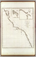
Full Title
A Chart Shewing part of the S.W. Coast of New Holland With the Tracks of His Majesty's Sloop Discovery and Armed Tender Chatham Commanded by George Vancouver Esqr. in the Year 1791. Engraved by T. Foot. Weston Place, Battle Bridge. No. 1. (with) eight inset maps. London. Published May 1st 1798, by J. Edwards Pall Mall and G. Robinson Paternoster Row.
List No
3354.001
Note
All maps uncolored. Inset maps included are: 1. A Survey of King George IIId Sound on the S.W. Coast of New Holland. 2. Dusky Bay in New Zealand Copied from a sketch of Captain Cook's with such Additions and improvements as where made by the Discovery and Chatham, in the Year 1791. 3. Pickersgills Harbour. 4. Anchor Island Harbour. 5. Facile Harbour. 6. A Sketch of the Snares with the Track of the Chatham between them. 7. Chatham Island. 8. The Island of Oparo. Maps include soundings and the tracks of the ships around the islands.
Author
Vancouver, George, 1757-1798
Full Title
Views of Parts of the South West Coast of New Holland, with the Islands of Oparo and the Snares. W. Alexander delt. from Sketches made on the Spot by J. Sykes. London. Published May 1st 1798, by R. Edwards New Bond Street and J. Edwards Pall Mall and G. Robinson Paternoster Row. Engraved by B.T. Pouncy.
List No
3354.002
Note
Uncolored views include Cape Chatham, Cape Howe, King George IIId Sound, Point Hood, the Snares, and the Island of Oparo.
Author
Vancouver, George, 1757-1798
Full Title
A chart shewing part of the Coast of N.W. America, with the tracks of His Majesty's Sloop Discovery and armed tender Chatham, Commanded by George Vancouver Esq. and prepared under his immediate inspection by Lieut. Joseph Baker, in Which the Continental Shore has been finally traced and determined from Latd. 38¼15'N. and Longd. 237¼27'E. to Latd. 45¼46'N. and Longd. 236¼15'E. Engraved by B. Baker Islington. Plate 3. (with) Bay of Trinidad. London, published May 1, 1798 by J. Edwards Pall Mall, and G. Robinson Paternoster Row.
List No
3354.003
Note
Uncolored map labeled "Part of the Coast of New Albion." The map extends from Bodega Bay, California to Cape Lookout, Oregon.
Author
Vancouver, George, 1757-1798
Full Title
Views of Parts of the Coast of North West America. 4. W. Alexander delt. from Sketches made on the Spot. London. Published May 1st 1798, by R. Edwards New Bond Street, J. Edwards Pall Mall and G. Robinson Paternoster Row. Engraved by B.T. Pouncy.
List No
3354.004
Note
Uncolored views including Cape Mendocino, Cape Orford, Cape Gregory, Point Grenville, Cape Flattery, and Mount Olympus.
Author
Vancouver, George, 1757-1798
Full Title
A Chart shewing part of the Coast of N.W. America, with the tracks of His Majesty's Sloop Discovery and Armed Tender Chatham; Commanded by George Vancouver Esqr. and prepared under his immediate inspection by Lieut. Joseph Baker, in which the Continental Shore has been traced and determined from Lat. 45¼30'N. and Long. 236¼12' E. to Lat. 52¼15'N and Long 232¼40'E. at the different periods shown by the Tracks. Warner Sculp. 5. (with) three inset maps. London: Published May 1st 1798, by J. Edwards Pall Mall & G. Robinson Paternoster Row.
List No
3354.005
Note
Map uncolored and shaded. Note in the title cartouche states, "The parts not shaded are taken from Spanish Authorities." The large map shows the route north in unbroken lines, and the route south in dotted lines. Inset maps include: 1. Entrance of Columbia River 2. Gray's Harbour 3. Port Discovery. Map extends from Cape Lookout, Oregon in the south to Kings Island, British Columbia in the north.
Author
Vancouver, George, 1757-1798
Full Title
Views of Parts of the Coast of North West America. 6. W. Alexander delt. from Sketches made on the Spot. London. Published May 1st 1798, by R. Edwards New Bond Street, J. Edwards Pall Mall and G. Robinson Paternoster Row. Engraved by B.T. Pouncy.
List No
3354.006
Note
Uncolored views including Scots Islands, Cape Scot, Woody Point, Nootka Sound, Cape Disappointment and the entrance to the Columbia River, and Punto Barro de Arena.
Author
Vancouver, George, 1757-1798
Full Title
A Chart shewing part of the Coast of N.W. America, with the tracks of His Majesty's Sloop Discovery and Armed Tender Chatham; Commanded by George Vancouver Esqr. and prepared under his immediate inspection by Lieut. Joseph Baker, in which the Continental Shore has been traced and determined from Lat. 51¼45'N. and Long. 232¼08' E. to Lat. 57¼30'N and Long 226¼44'E. at the different periods shown by the Tracks. Warner Sculp. 7. (with) A Survey of Port Stewart. London: Published May 1st 1798, by J. Edwards Pall Mall & G. Robinson Paternoster Row.
List No
3354.007
Note
Map uncolored and shaded. Note in the title cartouche states, "The parts not shaded are taken from Spanish Authorities." The large map shows the route north in unbroken lines, and the route south in dotted lines. Map extends from Kings Island, British Columbia in the south to Admiralty Island, Alaska in the north.
Author
Vancouver, George, 1757-1798
Full Title
A Chart shewing part of the Coast of N.W. America, With the Tracks of His Majesty's Sloop Discovery and Armed Tender Chatham; Commanded by George Vancouver Esqr. and prepared under his immediate inspection by Lieut. Joseph Baker, in which the Continental Shore has been traced and determined from Lat. 30¼00'N. and Long. 244¼32' E. to Lat. 38¼30'N and Long 237¼13'E. Engraved by T. Foot, Weston Place, Battle Bridge. No. 8. (with) Entrance of Port Sn. Francisco. (and) Port Sn. Diego. London: Published May 1st 1798, by J. Edwards Pall Mall & G. Robinson Paternoster Row.
List No
3354.008
Note
Map uncolored and shaded. Note in the title cartouche states, "The parts shaded Red are taken from Spanish Authorities." (No red shading has been added to this copy.) The vessels' tracks are shown by dotted lines. Spanish Missions and Presidios are noted. Map extends from St. Domingo, Mexico in the south to Point Reyes, California in the north.
Author
Vancouver, George, 1757-1798
Full Title
Views of Parts of the Coast of North West America. 9. W. Alexander delt. from Sketches made on the spot. London: Published May 1st 1798, by R. Edwards New Bond Street, J. Edwards Pall Mall and G. Robinson Paternoster Row. J. Fittler sculp.
List No
3354.009
Note
Uncolored views including Punto de los Reyes and the Bay of Sir Francis Drake, Port of St. Francisco, Point Pinos, Santa Barbara, the entrance to the Port of St. Diego, and Cape Colnett.
Author
Vancouver, George, 1757-1798
Full Title
A Chart shewing part of the Coast of N.W. America, With the Tracks of His Majesty's Sloop Discovery and Armed Tender Chatham; Commanded by George Vancouver Esqr. and prepared under his immediate inspection by Lieut. Joseph Baker, in which the Continental Shore has been traced and determined from Latde. of 59¼30' North & Longde. 207¼20' East; to Cape Douglas in Latde. 58¼52' North and Longde. 207¼20' East. Engraved by S.J. Neele, 352 Strand. (with) A Survey of Port Chatham. London Published May 1st 1798, by T.R. Edwards Pall Mall & C. Robinson Paternoster Row.
List No
3354.010
Note
Maps without color. Note within the cartouche states, "The parts not shaded taken from Russian Authority." Unbroken lines show the ships' path as they went north. Dotted lines show the path of the ships as they sailed south. Map covers the area around Kodiak Island and the Kenai Peninsula in Alaska.
Author
Vancouver, George, 1757-1798
Full Title
A Chart Shewing part of the Coast of N.W. America, With the Tracks of His Majesty's Sloop Discovery and Armed Tender Chatham; Commanded by George Vancouver Esqr. and prepared under his immediate inspection by Lieut. Joseph Baker, in which the Continental Shore has been traced and determined from Latd. 59¼45'N. and Longd. 219¼30'E. to Latd. 59¼56'N and Longd. 212¼08'E. at the periods shewn by the Track. No. 11. (with) A Survey of Port Chalmers. Engraved by T. Foot, Weston Place, St. Pancras. London. Published May 1st 1798, by J. Edwards, Pall Mall & G. Robinson, Paternoster Row.
List No
3354.011
Note
Maps without color. Dotted lines show the path of the ships as they sailed south. Map covers Prince William's Sound and surrounding areas in Alaska.
Author
Vancouver, George, 1757-1798
Full Title
A Chart Shewing part of the Coast of N.W. America, With the Tracks of His Majesty's Sloop Discovery and Armed Tender Chatham; Commanded by George Vancouver Esqr. and prepared under his immediate inspection by Lieut. Joseph Baker, in which the Continental Shore has been traced and determined from Latde. 57¼07'1/2N. and Longd. 227¼00'E. to Latd. 59¼39'N and Longd. 219¼00'E. at the periods shewn by the Track. No. 12. (with) three inset maps. Engraved by T. Foot, Weston Place, St. Pancras. London: Published May 1st 1798, by J. Edwards Pall Mall & G. Robinson Paternoster Row.
List No
3354.012
Note
Maps without color. Inset maps include: 1. Entrance into Cross Sound. 2. A Survey of Port Conclusion. 3. A Survey of Port Protection. Dotted lines show the path of the ships as they sailed south. Maps cover the area in Alaska around the Alexander Archipelago.
Author
Vancouver, George, 1757-1798
Full Title
Views of Headlands and Islands on the Coasts of North West and South America. W. Alexander delt. from Sketches made on the spot. London: Published May 1st 1798, by J. Edwards Pall Mall & G. Robinson Paternoster Row. J. Fittler sculp.
List No
3354.013
Note
Numerous uncolored views of the coast, including Cook's Inlet at Port Chatham, Port San Blas, Mexico, and the Islet of Diego Ramirez to the south of Cape Horn.
Author
Vancouver, George, 1757-1798
Full Title
A Chart Shewing part of the Coast of N.W. America, With the Tracks of His Majesty's Sloop Discovery and Armed Tender Chatham; Commanded by George Vancouver Esqr. and prepared from the foregoing Surveys under his immediate inspection by Lieut. Edwd. Roberts in which the Continental Shore has been correctly Traced and Determined From Lat. 29¼54'N. and Long. 244¼33'E. to Cape Douglas in Lat. 58¼52'N and Longd. 207¼20'E. during the Summers of 1792, 1793, and 1794. 14. Warner Sculp. London: Published May 1st 1798, by J. Edwards Pall Mall & G. Robinson Paternoster Row.
List No
3354.014
Note
An uncolored map of the coast from western Alaska to northern Mexico. Note within cartouche states, "The parts not shaded to the Eastward of Cape Decision are taken from Spanish Authorities - and those not shaded to the Westward of Cape St. Hermogenes are taken from Russian Authorities." Full lines show the vessels' tracks north, with dotted lines showing the vessels' tracks south.
Author
Vancouver, George, 1757-1798
Full Title
A Chart of the Sandwich Islands as Surveyed during the Visits of His Majesty's Sloop Discovery and Armed Tender Chatham Commanded by George Vancouver Esq. in the Years 1792, 1793 & 1794, and prepared under his immediate inspection by Lieut. Joseph Baker. Engraved by J. Warner. 15. (with) Part of the Gallapagos Isles (and) the Island of Cocoas. London: Published May 1st, 1798, by J. Edwards Pall Mall & G. Robinson Paternoster Row.
List No
3354.015
Note
Uncolored maps of the Hawaiian and Galapagos Islands. The tracks of the ships, along with their dates, are shown.
Author
Vancouver, George, 1757-1798
Full Title
Views of the Sandwich and other Islands. 16. W. Alexander delt. from Sketches made on the spot. London: Published May 1st 1798, by J. Edwards Pall Mall and G. Robinson Paternoster Row. B.T. Pouncy sculp.
List No
3354.016
Note
Uncolored views of the Hawaiian and Galapagos islands.
Author
Vancouver, George, 1757-1798
Full Title
(Index Page) A List of Plates contained in the First Volume.
List No
3354.017
Author
Vancouver, George, 1757-1798
Full Title
(View) Plate I (in Volume I). A Deserted Indian Village in King George III Sound, New Holland.
List No
3354.018
Author
Vancouver, George, 1757-1798
Full Title
(View) Plate II (in Volume I). Four remarkable supported Poles in Port Townsend, Gulph of Georgia
List No
3354.019
Author
Vancouver, George, 1757-1798
Full Title
(View) Plate III (in Volume I). Mount Rainier from the South part of Admiralty Inlet.
List No
3354.020
Author
[Vancouver, George, 1757-1798, Headington, T.]
Full Title
(View) Plate IV (in Volume I). Village of the Friendly Indians at the Entrance of Bute's Canal.
List No
3354.021
Author
[Vancouver, George, 1757-1798, J. Sykes]
Full Title
(View) Plate V (in Volume I). Cheslakee's Village on Johnstone's Straits.
List No
3354.022
Author
Vancouver, George, 1757-1798
Full Title
(View) Plate VI (in Volume I). A Discovery on the Rocks in Queen Charlotte's Sound.
List No
3354.023
Author
[Vancouver, George, 1757-1798, Humphries, H.]
Full Title
(View) Plate VII (in Volume I). Friendly Cove, Nootka Sound.
List No
3354.024
Author
Vancouver, George, 1757-1798
Full Title
(Covers to) (Volume II) A Voyage Of Discovery To The North Pacific Ocean And Round The World In Which The Coast of North-West America Has Been Carefully Examined And Accurately Surveyed. Undertaken by His Majesty's Command, Principally With A View To Ascertain The Existence Of Any Navigable Communication Between The North Pacific and North Atlantic Oceans; And Performed In The Years 1790, 1791, 1792, 1793, 1794, and 1795 In The Discovery Sloop Of War, And Armed Tender Chatham, Under The Command Of Captain George Vancouver. In Three Volumes. London: Printed For G.G. And J. Robinson, Paternoster-Row; And J. Edwards, Pall-Mall. 1798.
List No
3354.025
Note
Dark green pebbled cloth-covered boards quarter bound with light brown leather. Spine text stamped in gilt, "Vancouver's Voyage, Vol. II."
Author
Vancouver, George, 1757-1798
Full Title
(Section Title Page) (Volume II) A Voyage Of Discovery To The North Pacific Ocean And Round The World In Which The Coast of North-West America Has Been Carefully Examined And Accurately Surveyed. Undertaken by His Majesty's Command, Principally With A View To Ascertain The Existence Of Any Navigable Communication Between The North Pacific and North Atlantic Oceans; And Performed In The Years 1790, 1791, 1792, 1793, 1794, and 1795 In The Discovery Sloop Of War, And Armed Tender Chatham, Under The Command Of Captain George Vancouver. In Three Volumes. Volume II. London: Printed For G.G. And J. Robinson, Paternoster-Row; And J. Edwards, Pall-Mall. 1798.
List No
3354.026
Author
Vancouver, George, 1757-1798
Full Title
(Index Page) A List of Plates contained in the Second Volume.
List No
3354.027
Author
[Vancouver, George, 1757-1798, Sykes, J.]
Full Title
(View) Plate I (in Volume II). The Mission of St. Carlos, near Monterrey.
List No
3354.028
Author
Vancouver, George, 1757-1798
Full Title
Plate II (in Volume II). Chart of Hergest's Islands.
List No
3354.029
Author
[Vancouver, George, 1757-1798, Heddington, T.]
Full Title
(View) Plate III (in Volume II). Salmon Cove, Observatory Inlet.
List No
3354.030
Author
[Vancouver, George, 1757-1798, Sykes, F.]
Full Title
(View) Plate IV (in Volume II). The New Eddystone in Bhem's Canal.
List No
3354.031
Author
[Vancouver, George, 1757-1798, Sykes, J.]
Full Title
(View) Plate V (in Volume II). The Presidio of Monterrey.
List No
3354.032
Author
Vancouver, George, 1757-1798
Full Title
(Covers to) (Volume III) A Voyage Of Discovery To The North Pacific Ocean And Round The World In Which The Coast of North-West America Has Been Carefully Examined And Accurately Surveyed. Undertaken by His Majesty's Command, Principally With A View To Ascertain The Existence Of Any Navigable Communication Between The North Pacific and North Atlantic Oceans; And Performed In The Years 1790, 1791, 1792, 1793, 1794, and 1795 In The Discovery Sloop Of War, And Armed Tender Chatham, Under The Command Of Captain George Vancouver. In Three Volumes. London: Printed For G.G. And J. Robinson, Paternoster-Row; And J. Edwards, Pall-Mall. 1798.
List No
3354.033
Note
Dark green pebbled cloth-covered boards quarter bound with light brown leather. Spine text stamped in gilt, "Vancouver's Voyage, Vol. III."
Author
Vancouver, George, 1757-1798
Full Title
(Section Title Page) (Volume III) A Voyage Of Discovery To The North Pacific Ocean And Round The World In Which The Coast of North-West America Has Been Carefully Examined And Accurately Surveyed. Undertaken by His Majesty's Command, Principally With A View To Ascertain The Existence Of Any Navigable Communication Between The North Pacific and North Atlantic Oceans; And Performed In The Years 1790, 1791, 1792, 1793, 1794, and 1795 In The Discovery Sloop Of War, And Armed Tender Chatham, Under The Command Of Captain George Vancouver. In Three Volumes. Volume III. London: Printed For G.G. And J. Robinson, Paternoster-Row; And J. Edwards, Pall-Mall. 1798.
List No
3354.034
Author
Vancouver, George, 1757-1798
Full Title
(Index Page) A List of Plates contained in the Third Volume.
List No
3354.035
Author
[Vancouver, George, 1757-1798, Heddington, T.]
Full Title
(View) Plate I (in Volume III). The Crater on the Summit of Mount Worroray - Owhyhee.
List No
3354.036
Author
[Vancouver, George, 1757-1798, Humphries, H.]
Full Title
(View) Plate II (in Volume III). Port Dick, near Cook's Inlet.
List No
3354.037
Author
[Vancouver, George, 1757-1798, Heddington, F.]
Full Title
(View) Plate III (in Volume III). Icy Bay and Mount St. Elias.
List No
3354.038
Author
[Vancouver, George, 1757-1798, Sykes, J.]
Full Title
(View) Plate IV (in Volume III). A. Remarkable Mountain near the River of Monterrey.
List No
3354.039
Author
[Vancouver, George, 1757-1798, Sykes, J.]
Full Title
(View) Plate V (in Volume III). The Town of Valparaiso on the Coast of Chili.
List No
3354.040
Author
[Vancouver, George, 1757-1798, Sykes, J.]
Full Title
(View) Plate VI (in Volume III). The Village of Almandral in the Bay of Valparaiso with a distant View of the Andes.
List No
3354.041
Author
Vancouver, George, 1757-1798
Full Title
Carte de la partie de la cote nord-ouest de l'Amerique. Reconnue pendant les Etes de 1792, 1793 et 1794 depuis 29054' de latitude nord et 244033' de longitude orientale, jusqu'a au Cap Douglas par 58052' de latitude et 207020' de longitude, par le Capitaine Georges Vancouver commandant la Decouverte et le Chatham; avec les routes de ces deux batimens; Redigee par le Lieutenant Edward Roberts d'apres les reconnaissances et les observations. Voyage de Vancouver. No. 3. (Paris: Depot-general de la Marine, 1828)
List No
0233.004
Note
Engraved map. Relief shown by hachures and pictorially. Covers the coast from western Alaska to northern Mexico. Full lines show the vessels' tracks north, with dotted lines showing the vessels' tracks south. Note below cartouche: Les cotes sans ombres dans l'est du Cap decision sout tirees des cartes Espagnoles; Les cotes sans ombres dans l'ouest de l'Ile St. Hermogene sone tirees des cartes Russes.
Author
Vancouver, George, 1757-1798
Full Title
Cote nord-ouest de l'Amerique. Reconnue par le Cape. Vancouver. 1e. partie, depuis 3000' de latitude septle. et 244032' de longitude jusqu'a 38030' de late. et 237013' de longe. (with) Port St. Diego. (with) Entree de Port St. Francisco. Voyage de Vancouver. No. 4. (Paris: Depot-general de la Marine, 1828)
List No
0233.005
Note
Engraved map. Relief shown pictorially; depths by soundings. Covers the coast from Bodega Bay, California to El Rosario, Baja California. Shows vessels' tracks. Inset maps show relief by hachures; depths by soundings.
Author
Vancouver, George, 1757-1798
Full Title
Cote nord-ouest de l'Amerique. Reconnue par le Cape. Vancouver. 2e. partie, depuis 38015' de latitude septle. et 237027' de longitude jusqu'a 45046' de late. et 236015' de longe. (with) Baie de la Trinidad. Voyage de Vancouver. No. 5. (Paris: Depot-general de la Marine, 1828)
List No
0233.006
Note
Engraved map. Relief shown pictorially; depths by soundings. Covers the coast from Bodega Bay, California to Cape Lookout, Oregon. Shows vessels' tracks. Inset map show relief by hachures; depths by soundings.
Author
Vancouver, George, 1757-1798
Full Title
Cote nord-ouest de l'Amerique. Reconnue par le Cape. Vancouver. 3e. partie, depuis 45030' de latitude septle. et 236012' de longitude, jusqu'a 52015' de late. et 232040' de longe. (with) Havre de Gray. (with) Port de la Decouverte. (with) Entree de la Riviere Columbia. Voyage de Vancouver. No. 6. (Paris: Depot-general de la Marine, 1828)
List No
0233.007
Note
Engraved map. Relief shown pictorially and by hachures; depths by soundings. Covers the coast from Cape Lookout, Oregon to Milbanke Sound, B.C. Shows vessels' tracks. Inset map show relief by hachures; depths by soundings. "Les parties de cotes qui ne sont pas ombrees sont tirees des plans Espagnols."
Author
Vancouver, George, 1757-1798
Full Title
Cote nord-ouest de l'Amerique. Reconnue par le Cape. Vancouver. IVe. partie, depuis 51045' de latitude septentle. et 23208' de longitude, jusqu'a 57030' de latitde. et 226044' de longe. (with) Plan du Port Stewart. Voyage de Vancouver. No. 7. (Paris: Depot-general de la Marine, 1828)
List No
0233.008
Note
Engraved map. Relief shown pictorially and by hachures; depths by soundings. Covers the coast from Milbanke Sound, B.C. to Chatham Strait, Alaska. Shows vessels' tracks.
Author
Vancouver, George, 1757-1798
Full Title
Cote nord-ouest de l'Amerique. Reconnue par le Cape. Vancouver. Ve. partie, depuis 5707'30" de latitude septle. et 22700' de longitude, jusqu'a 59059' de late. et 21900' de longe. (with) Plan du Port Conclusion. (with) Plan de Port Protection. (with) Plan de l'entree de Cross-Sound. Voyage de Vancouver. No. 8. (Paris: Depot-general de la Marine, 1828)
List No
0233.009
Note
Engraved map. Relief shown pictorially and by hachures; depths by soundings. Covers the coast from Christian Sound to Icy Bay, Alaska. Shows vessels' tracks.
|