Who What Where WhenWHEREShow More |
Author
[Munster, Sebastian, 1488-1552, Ptolemy, Claudius, Pirckheimer, Willibald, 1470-1530]
Full Title
(Text Page to) Anglicanae insulae noua descriptio, complectens & Hiberniae & Scotiae propinquiores limites ... (to accompany) Geographia universalis, vetus et nozva, complectens Claudii Ptolemaei Alexandrini enarrationis libros VIII ... Basileae apud Henricum Petrum Mense Martio anno M.D. XL (1540).
List No
11623.066
Note
Descriptive text to the modern map of British Isles, covering England, Wales, southern Scotland and the eastern portion of Ireland, printed within ornamental woodcut borders.
Author
[Ptolemy, Claudius, Ruscelli, Girolamo, Giuseppe Moletti, M.]
Full Title
Tabvla Asiae II. Dell' Asia, Tavola Seconda antica. (To accompany) La geografia di Claudio Tolomeo Alessandrino, nuouamente tradotta di Greco in Italiano, da Girolamo Ruscelli ... In Venetia, Appresso Vincenzo Valgrisi, M.D.LXI. (1561).
List No
11311.040
Note
Engraved map of ancient region of Asiatic Sarmatia, now Southern Russia and part of Ukraine, around the Azov sea. Relief shown pictorially.
Author
[Ptolemy, Claudius, Ruscelli, Girolamo, Giuseppe Moletti, M.]
Full Title
Orbis descriptio. Tavola Vniversal : Nvova, con la descrittione di Tvtto il Mondo. (To accompany) La geografia di Claudio Tolomeo Alessandrino, nuouamente tradotta di Greco in Italiano, da Girolamo Ruscelli ... In Venetia, Appresso Vincenzo Valgrisi, M.D.LXI. (1561).
List No
11311.063
Note
Double hemispherical modern copper plate engraving world map, based upon Gastaldi's world map of 1548. No southern continent is shown. The map clearly shows the broad mass of land joining Asia and America as Terra Incognita and the coastline as Littus Incongmitum. Relief shown pictorially.
Author
[Ptolemy, Claudius, Ruscelli, Girolamo, Giuseppe Moletti, M.]
Full Title
Africa Nvova tavola. Africa nvova, Ventesimaseconda nvova tavola. (To accompany) La geografia di Claudio Tolomeo Alessandrino, nuouamente tradotta di Greco in Italiano, da Girolamo Ruscelli ... In Venetia, Appresso Vincenzo Valgrisi, M.D.LXI. (1561).
List No
11311.107
Note
Engraved map of South Africa. Relief shown pictorially.
Author
[Ptolemy, Claudius, Ruscelli, Girolamo, Giuseppe Moletti, M.]
Full Title
Nveva Hispania tabvla nova. Nveva Hispania, Trentesimaprima tavola nvova. (To accompany) La geografia di Claudio Tolomeo Alessandrino, nuouamente tradotta di Greco in Italiano, da Girolamo Ruscelli ... In Venetia, Appresso Vincenzo Valgrisi, M.D.LXI. (1561).
List No
11311.125
Note
Engraved map of New Spain. Showing Mexico and Central America, the southern United States, including Florida. California is a peninsula and in the vicinity of the Colorado River flows the R. Tontonteanc, showing Sier Anevada (Sierra Nevada). Relief shown pictorially.
Author
[Ptolemy, Claudius, Ruscelli,Girolamo, Rosaccio, Giuseppe]
Full Title
Orbis Terrae Compendiosa Descriptio. Descrittione di tutta la Terra. Libro Primo. (to accompany) Geographia di Clavdio Tolomeo alessandrino, tradotta di Greco nell'idioma volgare Italiano da Girolamo Ruscelli ... In Venetia, MDXCIX (1599) Appresso gli heredi di M. Sessa.
List No
11299.034
Note
Engraved double hemispherical world map. The engraving is a model of clarity and neatness, with typical cursive flourishes to the lettering of the sea names. The North Pole is illustrated as a land mass surrounding a sea from which four rivers radiate, and there is a well depicted northwest passage. Shows a huge southern continent and the bulge in the south west coast of South America. Relief shown pictorially.
Author
[Ptolemy, Claudius, Ruscelli,Girolamo, Rosaccio, Giuseppe]
Full Title
Orbis descriptio. Descrittione dell' Europa. Libro Primo. (to accompany) Geographia di Clavdio Tolomeo alessandrino, tradotta di Greco nell'idioma volgare Italiano da Girolamo Ruscelli ... In Venetia, MDXCIX (1599) Appresso gli heredi di M. Sessa.
List No
11299.035
Note
The second plate of double hemispherical modern copper plate engraving world map,, based upon Gastaldi's world map of 1548. With addition of Southern continent. The map clearly shows the broad mass of land joining Asia and America as Terra Incognita and the coastline as Littus Incongmitum. Relief shown pictorially. Title at head of map: Descrittione dell'Europa. Libro Primo.
Author
[Ptolemy, Claudius, Ruscelli,Girolamo, Rosaccio, Giuseppe]
Full Title
Africa Nvova tavola. Descrittione dell' Africa. Libro Secondo. (to accompany) Geographia di Clavdio Tolomeo alessandrino, tradotta di Greco nell'idioma volgare Italiano da Girolamo Ruscelli ... In Venetia, MDXCIX (1599) Appresso gli heredi di M. Sessa.
List No
11299.058
Note
Engraved map of South Africa. Relief shown pictorially.
Author
[Ptolemy, Claudius, Ruscelli,Girolamo, Rosaccio, Giuseppe]
Full Title
Nveva Hispania tabvla nova. Descrittione dell'America. Libro Quarto. (to accompany) Geographia di Clavdio Tolomeo alessandrino, tradotta di Greco nell'idioma volgare Italiano da Girolamo Ruscelli ... In Venetia, MDXCIX (1599) Appresso gli heredi di M. Sessa.
List No
11299.068
Note
Engraved map of New Spain. Showing the southern United States, including Texas and Florida and Mexico and Central America. California is a peninsula and in the vicinity of the Colorado River flows the R. Tontonteanc, with place names, showing Sier Anevada (Sierra Nevada). Relief shown pictorially.
Author
[Mercator, Gerhard, 1512-1594, Hondius, Iodocus, 1563-1612]
Full Title
Typus orbis terrarum : domini est terra & plenitudo, ejus, orbis terrarum, & universi qui habitant in eo : Psalmo 24. (to accompany) Atlas minor Gerardi Mercatoris.
List No
11201.010
Note
Double Hemispheres colored map, with decorative border depicting the continents. Terra Australis Incognita fills the Southern Hemisphere and connects to New Guinea in the region of Australia. Northwest Passage and interesting polar islands have been replaced with a non-descript landmass. The eastern coast of Asia has been revised to include a Korean Peninsula. South America is shown. An elongated Northwest Coast of America is shown, along with Anian.
Author
[Wytfliet, Corneille, Magini, Giovanni Antonio]
Full Title
Utriusque Hemispherii Delineatio. (to accompany) Histoire universelle des Indes occidentales et orientales, et de la conversion des Indiens : divisee en trois parties par Cornille Wytfliet & Anthoine Magin & autres historiens. Premiere Partie. A Douay, Chez Francois Fabri, l'An 1611.
List No
11622.009
Note
Double page uncolored engraved double hemisphere map of the world, supported by vignette of Atlas from below, with title cartouche. Showing Terra Australis fills the Southern Hemisphere, Quivira and Anian are named on the West Coast of North America. Florida and Norimbega are shown on the Eastern Coast of North America. Includes rivers and mountains. Relief shown pictorially.
Author
[Wytfliet, Corneille, Magini, Giovanni Antonio]
Full Title
Chica sive Patagonica et Australis Terra. (to accompany) Histoire universelle des Indes occidentales et orientales, et de la conversion des Indiens : divisee en trois parties par Cornille Wytfliet & Anthoine Magin & autres historiens. Premiere Partie. A Douay, Chez Francois Fabri, l'An 1611.
List No
11622.013
Note
Uncolored engraved double page map divided in two sections. Shows Strait of Magellan or Patagonia and at the bottom shows a polar view of the Terra Australis with Southern Africa and Madagascar. Relief shown pictorially. Includes decorative title cartouche.
Author
[Wytfliet, Corneille, Magini, Giovanni Antonio]
Full Title
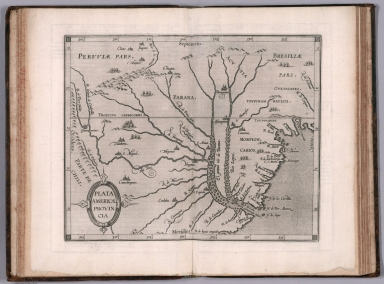
Plata Americae provincia. (to accompany) Histoire universelle des Indes occidentales et orientales, et de la conversion des Indiens : divisee en trois parties par Cornille Wytfliet & Anthoine Magin & autres historiens. Premiere Partie. A Douay, Chez Francois Fabri, l'An 1611.
List No
11622.020
Note
Uncolored engraved double page map of the Rio de la Plata region. Covers Argentina, Uruguay and the southern part of Brazil. Shows cities, towns, landmarks, rivers, capes, bays and mountains. Relief shown pictorially. Includes decorative title cartouche.
Author
Herrera y Tordesillas, Antonio de, -1625
Full Title
(Title Page to) Descriptio Indiæ Occidentalis per Antonium de Herrera regium Indiarum et Castellæ historiographum.
List No
14476.005
Note
Title page to Descriptio Indiæ Occidentalis per Antonium de Herrera regium Indiarum et Castellæ historiographum, the first part of Nieuwe werelt anders ghenaempt West-Indien. Title translates to: A description of the West Indies by Antonius de Herrera, the royal historian of the Indies and Castile. Includes an engraved map of the Western Hemisphere, which features the earliest known published image California as an island, a cartographic myth that persisted until the 18th century. Decorated with engraved Castilian coat of arms, and eight vignettes showing Aztec gods and scenes of Nova Hispania [Mexico], including a temple.
Author
Herrera y Tordesillas, Antonio de, -1625
Full Title
Descripcion de las Indias Ocidentalis.
List No
14476.006
Note
Map of the Western Hemisphere, featuring the West Indies. Shows countries, cities, topography, bodies of water, drainage, coastlines and islands. Relief shown pictorially. Includes latitudinal lines and longitudinal lines, as well as a descriptive note. Black and white engraving. Map is 23 x 32 cm, on double sheet 29 x 36 cm. Appears in Descriptio Indiae Occidentalis per Antonium de Herrera regium Indiarum et Castellae historiographum, the first part of Nieuwe werelt anders ghenaempt West-Indien. (Plate number inferred.)
Author
[Mercator, Gerhard, 1512-1594, Hondius, Jodocus, 1563-1612, Saltonstall, Wye]
Full Title
Typus orbis terrarum : domini est terra & plenitudo, ejus, orbis terrarum, & universi qui habitant in eo : Psalmo 24. (at head of the sheet) Of the world. (to accompany) Historia mundi : or Mercator's atlas. London Printed for Michaell Sparke, and are to be sowld in Greene Arboiure, 1637. Second edytion.
List No
11248.049
Note
Copper-engraving, uncolored double hemisphere map of the world, reduced version of Mercator`s famous world map includes several updates. The map is richly decorated in a strapwork surround with the title at top, the word ""Jehova"" in Hebrew just below. Showing Terra Australis Incognita fills the Southern Hemisphere and connects to New Guinea in the region of Australia. Northwest Passage and interesting polar islands have been replaced with a non-descript landmass. The eastern coast of Asia has been revised to include a Korean Peninsula. Several place names noted in the map, including Anian, Tolm, Norumbega, Virginia and Florida.
Author
de Fer, Antoine
Full Title
[Celestial Chart of Southern Hemisphere with Horoscope and Astrological Information, Printed in Mirror Image]
List No
15382.001
Note
Date estimated.
Author
de Fer, Antoine
Full Title
(Reverse) [Celestial Chart of Southern Hemisphere with Horoscope and Astrological Information, Printed in Mirror Image]
List No
15382.002
Note
Date estimated.
Author
[Sanson, Nicolas, 1600-1667, Jollain, Gerhard, Berey, Nicolas, Du Val, Pierre, 1619-1683]
Full Title
(Covers to) [Composite World Atlas]
List No
15185.001
Author
[Jollain, Gerhard, Hondius, Jodocus]
Full Title
Nova Totius Terrarum Orbis Geographica Ac Hydrographica Tabula .
List No
15185.002
Author
[Berey, Nicolas, Jaillot, Hubert]
Full Title
L'Europe Corrigee, et augmentee, desus toutes les aultres cy devant faictes.
List No
15185.003
Author
Berey, Nicolas
Full Title
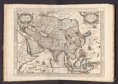
Carte L'Asie Corrigee, et augmentee, desus toutes les aultres cy devant faictes
List No
15185.004
Author
Berey, Nicolas
Full Title
Carte L'Afrique Corrigee, et augmentee, desus toutes les aultres cy devant faictes .
List No
15185.005
Author
Berey, Nicolas
Full Title
Carte L'Amerique Corrigee, et augmentee, desus toutes les aultres cy devant faictes . . .
List No
15185.006
Author
Jollain, Gerhard
Full Title
Carte General d'Hespagne
List No
15185.007
Author
Mariette, Pierre-Jean, 1603-1657
Full Title
Catalogne et Arragon .
List No
15185.008
Note
(later variant of Mariette, with changes -- "quay de l'orloge du palais aux 3 courones" address was later used by F.D. LaPointe)
Author
Jollain, Gerhard
Full Title
Galliae Regni Potentiss: Nova Descriptio Ionnae Ioliveto Auctore
List No
15185.009
Author
Sanson, Nicolas, 1600-1667
Full Title
Navarre
List No
15185.010
Author
Jollain, Gerhard
Full Title
Portugalliae Quae olim Lusitania Novissima et Exactissima Descriptio
List No
15185.011
Author
Lagniet
Full Title
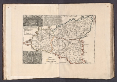
Royaume de Sicile
List No
15185.012
Author
Jollain, Gerhard
Full Title
Carte d'Italie Corsique Sardegne Et Roy Aumes Sircumuysines
List No
15185.013
Author
[Tavernier, Melchior, 1594-1665, Mariette, Pierre-Jean, 1603-1657]
Full Title
Carte Generale De l'Empire D'Allemagne et Pays Circonvoisins . . .
List No
15185.014
Author
Du Val, Pierre, 1619-1683
Full Title
Carte de L'Empire d'Alemagne par P. Duval .
List No
15185.015
Author
Mercator, Gerhard, 1512-1594
Full Title
Episcopatus Bremensis cum Adiacentibus
List No
15185.016
Note
date estimated.
Author
[Sanson, Nicolas, 1600-1667, Mariette, Pierre-Jean, 1603-1657]
Full Title
Partie Septentrionale du Royme de Hongrie tiree de divers Autheurs .
List No
15185.017
Author
[Sanson, Nicolas, 1600-1667, Mariette, Pierre-Jean, 1603-1657]
Full Title
Partie Meridionale du Royme de Hongrie tiree de divers Autheurs . . .
List No
15185.018
Author
Hondius, Hendrik, 1597-1651
Full Title
Ducatus Silesiae Wolanus
List No
15185.019
Author
[Lazius, Wolfgang, 1514-1565, Berey, Nicolas]
Full Title
Austria Archiducatgus Auctore Wolfgango Lazio
List No
15185.020
Author
Jollain, Gerhard
Full Title
Nouvelle Carte Generalle Des Dix Sept Provinces
List No
15185.021
Author
Lagniet
Full Title
Carte des Provinces Unies des Pays Bas connues soubs le nom de Hollande et pays circonvoisins ou l'on voitee qu'elles ont possede depuis leur Union a Utrecht l'an 1579 jusques a l'annee 1672 que la France a reduit en partie a son obeissace …
List No
15185.022
Author
Berey, Nicolas
Full Title
Carte De La Duche et Gouverement de Lorraine Par Blaeu
List No
15185.023
Author
[Bussemarcher, Jollain, Gerhard]
Full Title
Lotharingiae Ducatus Superioris vera delineatio
List No
15185.024
Note
This map would appear to be the original Bussemacher plate (circa 1600), re-worked by Jollain
Author
Du Val, Pierre, 1619-1683
Full Title
La Suisse Par P. Du Val
List No
15185.025
Author
Mercator, Gerhard, 1512-1594
Full Title
Tar Visina Marchia et Tirolis Comitatus
List No
15185.026
Author
Berey, Nicolas
Full Title
Gouvernement General du Duche de Bourgogne, comte de Bresse Pays de Buge Valromey, et Gex & c.
List No
15185.027
Author
Langlois, Nicolas
Full Title
Carte du Gouvernement de Provence
List No
15185.028
Author
Langlois, Nicolas
Full Title
Carte du Gouvernement de Languedoc
List No
15185.029
Author
Langlois, Nicolas
Full Title
Carte du Gouvernement de Guinne
List No
15185.030
Author
Tassin, J. B.
Full Title
Carte Generale de Poictou Xaintonge Angloumois et pays d'Aulnix
List No
15185.031
Author
Langlois, Nicolas
Full Title
Pictaviae Ducatus Descriptio Vugo Le Pais de Poictou
List No
15185.032
|


![[Celestial Chart of Southern Hemisphere with Horoscope and Astrological Information, Printed in Mirror Image]](https://www.davidrumsey.com/rumsey/Size2/RUMSEY~8~1/199/15382001.jpg)
![(Reverse) [Celestial Chart of Southern Hemisphere with Horoscope and Astrological Information, Printed in Mirror Image]](https://www.davidrumsey.com/rumsey/Size2/RUMSEY~8~1/199/15382002.jpg)
![Covers: [Composite World Atlas]](https://www.davidrumsey.com/rumsey/Size1/RUMSEY~8~1/199/15185001.jpg)


