|
Author
[Munster, Sebastian, 1448–1552, Ptolemy, Claudius, Pirckheimer, Willibald, 1470-1530]
Full Title
Typus Orbis Universalis. (to accompany) Geographia universalis, vetus et nova, complectens Claudii Ptolemaei Alexandrini enarrationis libros VIII ... Basileae apud Henricum Petrum Mense Martio anno M.D. XL (1540).
List No
11623.009
Note
Woodcut uncolored map of the world. The first map to name the pacific Ocean “Mare Pacificum”. Shows windheads around the map sea monsters, rivers and mountains. Relief shown pictorially.
Author
[Munster, Sebastian, 1448–1552, Ptolemy, Claudius, Pirckheimer, Willibald, 1470-1530]
Full Title
Novae Insulae XVII Nova Tabula. (to accompany) Geographia universalis, vetus et nozva, complectens Claudii Ptolemaei Alexandrini enarrationis libros VIII ... Basileae apud Henricum Petrum Mense Martio anno M.D. XL (1540).
List No
11623.100
Note
Woodcut uncolored map of the New World, the first edition of map of the continent of America, and the earliest map to show all of North and South America in a continental form. It is the first to name the Pacific Ocean (Mare Pacificum) and the Straits of Magellan, with his ship Victoria in the Pacific. Shows The flags of Spain (on Puerto Rico), place names, rivers and mountains. Relief shown pictorially. Included notes.
Author
Monte (Monti), Urbano, 1544-1613
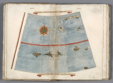
Full Title
Tavola XVIIII. Che Ha Sua Superiore La Tavola Nonaa. Libro Terzo.
List No
10130.021
Author
Monte (Monti), Urbano, 1544-1613
Full Title
Tavola XX. Che Ha Sua Superiore La Tavola. VIIII.E.X. Libro Terzo.
List No
10130.022
Author
Monte (Monti), Urbano, 1544-1613
Full Title
Tavola XXI. Che Ha Sua Superiore La Tavola. Decima. Libro Terzo.
List No
10130.023
Author
Monte (Monti), Urbano, 1544-1613
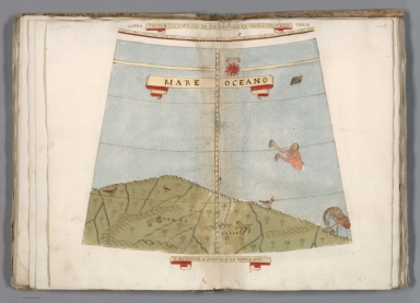
Full Title
Tavola XXII. Che Ha Sua Superiore La Tavola. XI. Libro Terzo.
List No
10130.024
Note
The note box has been cut out, indicating perhaps an intended revision that did not occur.
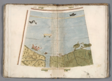
Author
Monte (Monti), Urbano, 1544-1613
Full Title
Tavola XXXVII. Che Ha Sua Superiore La Tavola. XXI. Libro Terzo.
List No
10130.039
Author
Monte (Monti), Urbano, 1544-1613
Full Title
Tavola XXXVIII. Che Ha Sua Superiore La Tavola. XXI. E.XXII. Libro Terzo.
List No
10130.040
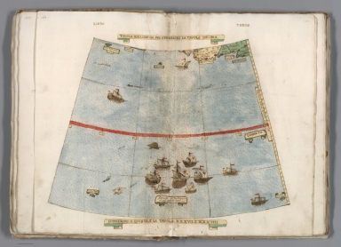
Author
Monte (Monti), Urbano, 1544-1613
Full Title
Tavola XXXVIIII. Che Ha Sua Superiore La Tavola. XXII. Libro Terzo.
List No
10130.041
Note
The long legend describes the first circumnavigation of the globe by Magellan, 1519-1522.
Author
[Mercator, Gerhard, 1512-1594, Mercator, Rumold, approximately 1545-1599]
Full Title
Septentrionalium Terrarum descriptio. Per Gerardum Mercatorem Cum Privilegio
List No
10805.001
Author
[Mercator, Gerhard, 1512-1594, Mercator, Rumold, approximately 1545-1599]
Full Title
(Text page to) Polus Arcticus. Ac Terrarum Circumjacentium descriptio.
List No
10805.002
Author
[Mercator, Gerhard, 1512-1594, Hondius, Iodocus, 1563-1612]
Full Title
Tartaria. (to accompany) Atlas minor Gerardi Mercatoris.
List No
11201.431
Note
Map of northern and central Asia stretching from the Caspian Sea and the Ural Mountains to the Pacific Ocean. Shows a small part of what is today Alaska and Korea as an island. Relief shown pictorially.
Author
[Ortelius, Abraham, 1527-1598, Vrients, Jan Baptista]
Full Title
Maris Pacifici, (quod vulg�� Mar del Zur) cum regionibus circumiacentibus, insulisque in eodem passim sparsis, novissima descriptio. Cum privilegiis Imp. & Reg. Maiestatum, nec non Cancellariae Brabantiae, ad decennium. Spe Et Metv Genio Et Ingenio Nobili Dn. Nicolao Roccoxio, Patricio Antverpiensi, Eivsdemqve Vrbis Senatori, Abrahamus Ortelius Regi�� Mts. geographus sub. merito dedicabat. 1589.
List No
10001.067
Author
[Wytfliet, Corneille, Magini, Giovanni Antonio]
Full Title
Castilia Aurifera cum vicinis provinciis. (to accompany) Histoire universelle des Indes occidentales et orientales, et de la conversion des Indiens : divisee en trois parties par Cornille Wytfliet & Anthoine Magin & autres historiens. Premiere Partie. A Douay, Chez Francois Fabri, l'An 1611.
List No
11622.030
Note
Uncolored engraved double page map of Colombia, extends from Panama to the Lake of Maracaibo (Venezuela), the Pacific and the Caribbean. Includes decorative title cartouche. Shows cities, towns, coastline, landmarks, rivers and mountains. Relief shown pictorially.
Author
[Wytfliet, Corneille, Magini, Giovanni Antonio]
Full Title
Limes Occidentis Quivira et Anian. (to accompany) Histoire universelle des Indes occidentales et orientales, et de la conversion des Indiens : divisee en trois parties par Cornille Wytfliet & Anthoine Magin & autres historiens. Premiere Partie. A Douay, Chez Francois Fabri, l'An 1611.
List No
11622.051
Note
Uncolored engraved double page map. Covers from Northern California coast to a mythical NW Passage in the Arctic Circle. Shows cities, towns, landmarks, rivers, forests and mountains. Relief shown pictorially. Includes decorative compass rose oriented with the north to the top left.
Author
[Herrera y Tordesillas, Antonio de, -1625, Ordóñez de Ceballos, Pedro, approximately 1545-approximately 1630, Le Maire, Jacques, 1585-1616]
Full Title
(Covers to) [Nieuwe werelt anders ghenaempt West-Indien. t'Amsterdam, by Michiel Colijn, Boeck-vercooper op't water by de oude brugh, in't huys-boeck. Anno 1622.]
List No
14476.001
Note
Covers to Nieuwe werelt anders ghenaempt West-Indien. Bound in vellum-covered board.
Author
[Herrera y Tordesillas, Antonio de, -1625, Ordóñez de Ceballos, Pedro, approximately 1545-approximately 1630, Le Maire, Jacques, 1585-1616]
Full Title
(Covers to) [Nieuwe werelt anders ghenaempt West-Indien. t'Amsterdam, by Michiel Colijn, Boeck-vercooper op't water by de oude brugh, in't huys-boeck. Anno 1622.] (Verso)
List No
14476.002
Note
Verso of front cover to Nieuwe werelt anders ghenaempt West-Indien. With early handwritten annotations, in ink, on pastedown.
Author
[Herrera y Tordesillas, Antonio de, -1625, Ordóñez de Ceballos, Pedro, approximately 1545-approximately 1630, Le Maire, Jacques, 1585-1616]
Full Title
(Title Page to) Nieuwe werelt anders ghenaempt West-Indien. t'Amsterdam, by Michiel Colijn, Boeck-vercooper op't water by de oude brugh, in't huys-boeck. Anno 1622.
List No
14476.003
Note
Title page to Nieuwe werelt anders ghenaempt West-Indien. Includes imprint. "Met privilege."
Author
[Herrera y Tordesillas, Antonio de, -1625, Ordóñez de Ceballos, Pedro, approximately 1545-approximately 1630, Le Maire, Jacques, 1585-1616, Aerssens, Cornelis van, 1545-1627]
Full Title
(Text Page to) Extract uyt de privilege. C. Aerssens.
List No
14476.004
Note
Dedication to Nieuwe werelt anders ghenaempt West-Indien. Authored by Cornelis van Aerssens (1545-1627), a statesman in Holland. With a historiated initial.
Author
Herrera y Tordesillas, Antonio de, -1625
Full Title
(Title Page to) Descriptio Indiæ Occidentalis per Antonium de Herrera regium Indiarum et Castellæ historiographum.
List No
14476.005
Note
Title page to Descriptio Indiæ Occidentalis per Antonium de Herrera regium Indiarum et Castellæ historiographum, the first part of Nieuwe werelt anders ghenaempt West-Indien. Title translates to: A description of the West Indies by Antonius de Herrera, the royal historian of the Indies and Castile. Includes an engraved map of the Western Hemisphere, which features the earliest known published image California as an island, a cartographic myth that persisted until the 18th century. Decorated with engraved Castilian coat of arms, and eight vignettes showing Aztec gods and scenes of Nova Hispania [Mexico], including a temple.
Author
Herrera y Tordesillas, Antonio de, -1625
Full Title
Descripcion de las Indias Ocidentalis.
List No
14476.006
Note
Map of the Western Hemisphere, featuring the West Indies. Shows countries, cities, topography, bodies of water, drainage, coastlines and islands. Relief shown pictorially. Includes latitudinal lines and longitudinal lines, as well as a descriptive note. Black and white engraving. Map is 23 x 32 cm, on double sheet 29 x 36 cm. Appears in Descriptio Indiae Occidentalis per Antonium de Herrera regium Indiarum et Castellae historiographum, the first part of Nieuwe werelt anders ghenaempt West-Indien. (Plate number inferred.)
Author
Herrera y Tordesillas, Antonio de, -1625
Full Title
Descripçion de las Indias del Norte.
List No
14476.007
Note
Map of the West Indies. Shows countries, audiencias (royal courts in Spanish colonial America), bodies of water, drainage, coastlines and islands. Includes latitudinal lines and longitudinal lines, as well as descriptive notes. Black and white engraving. Map is 21 x 29 cm, on double sheet 29 x 36 cm. Appears in Descriptio Indiae Occidentalis per Antonium de Herrera regium Indiarum et Castellae historiographum, the first part of Nieuwe werelt anders ghenaempt West-Indien.
Author
Herrera y Tordesillas, Antonio de, -1625
Full Title
Description del destricto del audiencia de la Española.
List No
14476.008
Note
Map of Hispaniola. Shows countries, regions, cities, bodies of water, drainage, coastlines, shoals and islands. Includes latitudinal lines and longitudinal lines. Indexed to indicate city names. Black and white engraving. Map is 21 x 29 cm, on double sheet 29 x 36 cm. Appears in Descriptio Indiae Occidentalis per Antonium de Herrera regium Indiarum et Castellae historiographum, the first part of Nieuwe werelt anders ghenaempt West-Indien.
Author
Herrera y Tordesillas, Antonio de, -1625
Full Title
Descripçion del destricto del audiencia de Nueva Espana.
List No
14476.009
Note
Map of Nueva Espana [New Spain] (current-day southern Mexico). Shows regions, cities, topography, bodies of water, drainage, coastlines and islands. Relief shown pictorially. Includes a descriptive note. Black and white engraving. Map is 21 x 29 cm, on double sheet 29 x 36 cm. Appears in Descriptio Indiae Occidentalis per Antonium de Herrera regium Indiarum et Castellae historiographum, the first part of Nieuwe werelt anders ghenaempt West-Indien.
Author
Herrera y Tordesillas, Antonio de, -1625
Full Title
Descripcion del destricto del audiencia de la Nueva Galicia.
List No
14476.010
Note
Map of Nueva Galicia [New Galicia] (current-day southern Mexico). Shows regions, cities, topography, bodies of water, drainage, coastlines and islands. Relief shown pictorially. Includes a descriptive note. Black and white engraving. Map is 21 x 29 cm, on double sheet 29 x 36 cm. Appears in Descriptio Indiae Occidentalis per Antonium de Herrera regium Indiarum et Castellae historiographum, the first part of Nieuwe werelt anders ghenaempt West-Indien.
Author
Herrera y Tordesillas, Antonio de, -1625
Full Title
Descripcion del audiencia de Guatimala.
List No
14476.011
Note
Map of Guatemala. Shows countries, regions, cities, topography, bodies of water, drainage, coastlines, shoals and islands. Relief shown pictorially. Black and white engraving. Map is 21 x 29 cm, on double sheet 29 x 36 cm. Appears in Descriptio Indiae Occidentalis per Antonium de Herrera regium Indiarum et Castellae historiographum, the first part of Nieuwe werelt anders ghenaempt West-Indien.
Author
Herrera y Tordesillas, Antonio de, -1625
Full Title
Descripcion de las Indias de Mediodia.
List No
14476.012
Note
Map of South America. Shows countries, regions, topography, bodies of water, drainage, coastlines, shoals and islands. Relief shown pictorially. Includes latitudinal and longitudinal lines. Black and white engraving. Map is 21 x 29 cm, on double sheet 29 x 36 cm. Appears in Descriptio Indiae Occidentalis per Antonium de Herrera regium Indiarum et Castellae historiographum, the first part of Nieuwe werelt anders ghenaempt West-Indien.
Author
Herrera y Tordesillas, Antonio de, -1625
Full Title
Descripcion del audiencia de Panama.
List No
14476.013
Note
Map of Panama. Shows regions, cities, bodies of water, drainage, coastlines and islands. Includes descriptive notes. Black and white engraving. Map is 21 x 29 cm, on double sheet 29 x 36 cm. Appears in Descriptio Indiae Occidentalis per Antonium de Herrera regium Indiarum et Castellae historiographum, the first part of Nieuwe werelt anders ghenaempt West-Indien.
Author
Herrera y Tordesillas, Antonio de, -1625
Full Title
Descripcion del audiencia del Nuevo Reino.
List No
14476.014
Note
Map of Nuevo Reino ["New Kingdom"] (current-day northwestern Venezuela). Shows regions, cities, bodies of water, drainage, coastline and islands. Includes descriptive notes. Black and white engraving. Map is 21 x 29 cm, on double sheet 29 x 36 cm. Appears in Descriptio Indiae Occidentalis per Antonium de Herrera regium Indiarum et Castellae historiographum, the first part of Nieuwe werelt anders ghenaempt West-Indien.
Author
Herrera y Tordesillas, Antonio de, -1625
Full Title
Descripcion del audiencia del Quito.
List No
14476.015
Note
Map of Quito and vicinity, Ecuador. Shows regions, topography, cities, bodies of water, drainage, coastline and islands. Relief shown pictorially. Includes descriptive notes. Black and white engraving. Map is 21 x 29 cm, on double sheet 29 x 36 cm. Appears in Descriptio Indiae Occidentalis per Antonium de Herrera regium Indiarum et Castellae historiographum, the first part of Nieuwe werelt anders ghenaempt West-Indien.
Author
Herrera y Tordesillas, Antonio de, -1625
Full Title
Descripcion del destrieto del audiencia de Lima.
List No
14476.016
Note
Map of Lima and vicinity, Peru. Shows regions, cities, topography, bodies of water, drainage, coastline and islands. Relief shown pictorially. Includes descriptive notes. Black and white engraving. Map is 21 x 29 cm, on double sheet 29 x 36 cm. Appears in Descriptio Indiae Occidentalis per Antonium de Herrera regium Indiarum et Castellae historiographum, the first part of Nieuwe werelt anders ghenaempt West-Indien.
Author
Herrera y Tordesillas, Antonio de, -1625
Full Title
Descripcion del audiencia de los Charcas.
List No
14476.017
Note
Map of Charcas (current-day Bolivia). Shows regions, cities, topography, bodies of water, drainage, coastline and islands. Relief shown pictorially. Includes descriptive notes. Black and white engraving. Map is 21 x 29 cm, on double sheet 29 x 36 cm. Appears in Descriptio Indiae Occidentalis per Antonium de Herrera regium Indiarum et Castellae historiographum, the first part of Nieuwe werelt anders ghenaempt West-Indien.
Author
Herrera y Tordesillas, Antonio de, -1625
Full Title
Descripcion de la Provincia de Chile.
List No
14476.018
Note
Map of Chile. Shows cities, topography, bodies of water, drainage, coastline and islands. Relief shown pictorially. Includes descriptive notes. Black and white engraving. Map is 21 x 29 cm, on double sheet 29 x 36 cm. Appears in Descriptio Indiae Occidentalis per Antonium de Herrera regium Indiarum et Castellae historiographum, the first part of Nieuwe werelt anders ghenaempt West-Indien.
Author
Herrera y Tordesillas, Antonio de, -1625
Full Title
Descripcion de las del Poniente.
List No
14476.019
Note
Map of areas including the East Indies, Papua New Guinea and the Solomon Islands. Shows countries, cities, bodies of water, drainage, coastlines and islands. Includes latitudinal and longitudinal lines. Indexed to indicate city names. Black and white engraving. Map is 21 x 29 cm, on double sheet 29 x 36 cm. Appears in Descriptio Indiae Occidentalis per Antonium de Herrera regium Indiarum et Castellae historiographum, the first part of Nieuwe werelt anders ghenaempt West-Indien.
Author
Ordóñez de Ceballos, Pedro, approximately 1545-approximately 1630
Full Title
(Title Page to) Eyghentlijcke Beschryvinghe van West-Indien : Hoe die Landen en Provientien Gheleghen zijn, op wat maniere datmen die door reysen sal : Ende wat Buckdommen van gout en silver elcke plaetse begrupt : Ghedaen. Van Pedro Ordonnez, de Cevallos, priester. Die de Landen met groote neersticheyt doorreylt en besichticht heeft. Tot Amsterdam, by Michiel Colijn, Boeck-vercooper op't water, in't huys-boeck. Anno 1621.
List No
14476.020
Note
Title page to Eyghentlijcke Beschryvinghe van West-Indien, the second part of Nieuwe werelt anders ghenaempt West-Indien. Title translates to: Description of the West Indies. Includes a woodcut vignette of a landscape with an animal.
Author
Le Maire, Jacques, 1585-1616
Full Title
(Title Page to) Spieghel der Australische navigatie, door dey wijt bermaerden ende cloeckmoedighen Zee-heldt / Jacob Maire, President ende Overste over de twee Schepen ... 14 Juni 1615. t'Amsterdam, by Michiel Colijn, Boeck-vercooper op't water, by de Dude Brugh, in't huys-boeck. Anno 1622.
List No
14476.021
Note
Title page to Spieghel der Australische navigatie, the third part of Nieuwe werelt anders ghenaempt West-Indien. Title translates (loosely) to: Southern navigation. Includes an engraved map of the world, featuring California as an island.
Author
Le Maire, Jacques, 1585-1616
Full Title
[Jacobus Lemarius].
List No
14476.022
Note
Portrait of author Jacques Le Marie (1585-1616) on verso of title page to Spieghel der Australische navigatie ..., the third part of Nieuwe werelt anders ghenaempt West-Indien. In the scene, Le Marie holds a map of "Zuider Zee" [Zuiderzee or Zuider Zee] (current-day IJssel Lake), a shallow bay of the North Sea in the northwest of the Netherlands.
Author
Le Maire, Jacques, 1585-1616
Full Title
[Patagones]. 1615 Decēb. Numero 1.
List No
14476.023
Note
View from Le Maire's travels in "Terra Australis" [Latin for "Southern Land"], featuring Puerto Deseado - "Port Desire" - in current-day Argentina. In December 1615, the expedition stopped in Port Desire for repairs. View shows topography, drainage, figures, fauna and flora. Relief shown figuratively. Includes a compass rose, with north oriented toward bottom of sheet. Indexed to indicate what appears within the view - such as ports, islands and sea lions - with key beneath. Black and white engraving. View is 20 x 17 cm, on sheet 29 x 19 cm. Appears in Spieghel der Australische navigatie, the third part of Nieuwe werelt anders ghenaempt West-Indien.
Author
Le Maire, Jacques, 1585-1616
Full Title
[Tierra del Fuogo].
List No
14476.024
Note
Map of Tierra del Fuego, an archipelago at South America’s southernmost tip, shared by current-day Chile and Argentina. Shows regions, bodies of water, drainage, coastlines and islands. Features voyages routes. Includes rhumb lines, latitudinal lines and a compass rose with north oriented toward top of sheet. With descriptive notes in cartouche. Black and white engraving. Map is 20 x 28 cm, on double sheet 29 x 36 cm. Appears in Spieghel der Australische navigatie, the third part of Nieuwe werelt anders ghenaempt West-Indien.
Author
Le Maire, Jacques, 1585-1616
Full Title
1616 Majus. Numero 2.
List No
14476.025
Note
View from Le Maire's travels in "Terra Australis" [Latin for "Southern Land"], featuring ships at sea. Shows figures sailing the ships and the surrounding water. Includes a compass rose, with north oriented toward bottom of sheet. Indexed to indicate parts of the main ship in the foreground. Black and white engraving. View is 20 x 17 cm, on sheet 29 x 19 cm. Appears in Spieghel der Australische navigatie, the third part of Nieuwe werelt anders ghenaempt West-Indien.
Author
Le Maire, Jacques, 1585-1616
Full Title
Cocos Eijlandt = Isle de Cocos. 1616 Majus. Numero 3.
List No
14476.026
Note
View from Le Maire's travels in "Terra Australis" [Latin for "Southern Land"], featuring ships in the harbor of The Cocos (Keeling) Islands, a remote area near current-day Australia in the Indian Ocean. Shows topography, vegetation, coastline, figures sailing the ships and the surrounding water. Relief shown pictorially. Indexed to indicate what appears within the view. Black and white engraving. View is 20 x 17 cm, on sheet 29 x 19 cm. Appears in Spieghel der Australische navigatie, the third part of Nieuwe werelt anders ghenaempt West-Indien.
Author
Le Maire, Jacques, 1585-1616
Full Title
1616 Majus. Numero 4.
List No
14476.027
Note
View from Le Maire's travels in "Terra Australis" [Latin for "Southern Land"], featuring a village of indigenous people. Shows topography, vegetation, coastline and figures on the beach. Relief shown pictorially. Indexed to indicate what appears within the view - such as coconut trees - with key beneath. Black and white engraving. View is 20 x 17 cm, on sheet 29 x 19 cm. Appears in Spieghel der Australische navigatie, the third part of Nieuwe werelt anders ghenaempt West-Indien.
Author
Le Maire, Jacques, 1585-1616
Full Title
Hoornse Eijlandt = Isle de Hoorn. Door Jacob le Maire. 1616 Majus. Numero 5.
List No
14476.028
Note
View from Le Maire's travels in "Terra Australis" [Latin for "Southern Land"], featuring current-day Unity Bay and coast of Hoorn Island [Futuna] in the South Sea. Shows topography, vegetation, drainage, coastline and figures on the beach and in ships. Relief shown pictorially. Indexed to indicate what appears within the view. Black and white engraving. View is 20 x 17 cm, on sheet 29 x 19 cm. Appears in Spieghel der Australische navigatie, the third part of Nieuwe werelt anders ghenaempt West-Indien.
Author
Le Maire, Jacques, 1585-1616
Full Title
[Pacific Ocean].
List No
14476.029
Note
Map of the Pacific Ocean, including the west coast of South America. Shows cities, bodies of water, drainage, coastlines and islands. Features voyages routes. Includes rhumb lines, latitudinal and longitudinal lines, as well as compass roses with north oriented toward top of sheet. With descriptive notes in cartouche. Black and white engraving. Map is 22 x 53 cm, on fold-out sheet 29 x 56 cm. Appears in Spieghel der Australische navigatie, the third part of Nieuwe werelt anders ghenaempt West-Indien.
Author
Le Maire, Jacques, 1585-1616
Full Title
Nova Guinea.
List No
14476.030
Note
Map of Papua New Guinea. Shows cities, bodies of water, drainage, coastlines and islands. Features voyages routes. Includes rhumb lines, latitudinal and longitudinal lines, as well as compass roses with north oriented toward top of sheet. With descriptive notes in cartouche. Black and white engraving. Map is 20 x 28 cm, on double sheet 29 x 36 cm. Appears in Spieghel der Australische navigatie, the third part of Nieuwe werelt anders ghenaempt West-Indien.
Author
[Herrera y Tordesillas, Antonio de, -1625, Ordóñez de Ceballos, Pedro, approximately 1545-approximately 1630, Le Maire, Jacques, 1585-1616, Aerssens, Cornelis van, 1545-1627]
Full Title
(Text Page to) Vocabulaer : Oft tale van d'eylanden Salomonis. (1)
List No
14476.031
Note
Vocabulary list for foreign languages appearing in Spieghel der Australische navigatie, the third part of Nieuwe werelt anders ghenaempt West-Indien. Includes section: Tale van het Cocos-Eylant [Cocos Island]. Spans four pages.
Author
[Herrera y Tordesillas, Antonio de, -1625, Ordóñez de Ceballos, Pedro, approximately 1545-approximately 1630, Le Maire, Jacques, 1585-1616, Aerssens, Cornelis van, 1545-1627]
Full Title
(Text Page to) Vocabulaer : Oft tale van d'eylanden Salomonis. (2)
List No
14476.032
Note
Vocabulary list for foreign languages appearing in Spieghel der Australische navigatie, the third part of Nieuwe werelt anders ghenaempt West-Indien. Includes sections: Tale van het Cocos-Eylant [Cocos Island] -- Tale oft spraecke van de Custe van Guinea nova [Coast of Papua New Guinea]. Spans four pages.
Author
[Herrera y Tordesillas, Antonio de, -1625, Ordóñez de Ceballos, Pedro, approximately 1545-approximately 1630, Le Maire, Jacques, 1585-1616, Aerssens, Cornelis van, 1545-1627]
Full Title
(Text Page to) Vocabulaer : Oft tale van d'eylanden Salomonis. (3)
List No
14476.033
Note
Vocabulary list for foreign languages appearing in Spieghel der Australische navigatie, the third part of Nieuwe werelt anders ghenaempt West-Indien. Includes sections: Tale oft spraecke van de Custe van Guinea nova [Coast of Papua New Guinea] -- Spraecke vant Eylant Moyses [Island Moyses] -- Spraecke van't Eylandt Moo [Island Moo]. Spans four pages.
Author
[Mercator, Gerhard, 1512-1594, Hondius, Jodocus, 1563-1612, Saltonstall, Wye]
Full Title
Tartarie. Tartaria. (to accompany) Historia mundi : or Mercator's atlas. London Printed for Michaell Sparke, . and are to be sowld in Greene Arboiure, 1637. Second edytion.
List No
11248.638
Note
Copper-engraving uncolored map of northern and central Asia stretching from the Caspian Sea and the Ural Mountains to the Pacific Ocean. Relief shown pictorially.
Author
[Hondius, Jodocus II, Goos, Abraham, Jansson, Johannes, 1588-1664]
Full Title
1. [Terrestial Globe] Nobilissimis, Amplissimis, Consultissimis, Prudentissimisq[ue], viris D. Dominis Societatis Indiarum Occidentalium Curatoribus suos hosce Coelestem Terrestremeque Globos Joannes Janssonius Humillimus Cliens L.M.Q. dat, dicat dedicatq[ue], Anno 1648
List No
15181.001
|


![Covers: [Nieuwe werelt anders ghenaempt West-Indien.]](https://www.davidrumsey.com/rumsey/Size2/RUMSEY~8~1/205/14476001.jpg)
![Covers: [Nieuwe werelt anders ghenaempt West-Indien.] (Verso)](https://www.davidrumsey.com/rumsey/Size2/RUMSEY~8~1/205/14476002.jpg)


![[Jacobus Lemarius].](https://www.davidrumsey.com/rumsey/Size1/RUMSEY~8~1/205/14476022.jpg)
![[Patagones]. 1615 Decēb. Numero 1.](https://www.davidrumsey.com/rumsey/Size1/RUMSEY~8~1/205/14476023.jpg)
![[Tierra del Fuogo].](https://www.davidrumsey.com/rumsey/Size2/RUMSEY~8~1/205/14476024.jpg)


![[Pacific Ocean].](https://www.davidrumsey.com/rumsey/Size2/RUMSEY~8~1/205/14476029.jpg)


![1. [Terrestrial Globe] Nobilissimis, Amplissimis, Consultissimis, Prudentissimisq[ue], viris D. Dominis Societatis Indiarum Occidentalium Curatoribus suos hosce Coelestem Terrestremeque Globos Joannes Janssonius Humillimus Cliens L.M.Q. dat, dicat dedicatq[ue], Anno 1648](https://www.davidrumsey.com/rumsey/Size1/RUMSEY~8~1/199/15181001.jpg)