|
REFINE
Search Results: All Fields similar to 'Baja and California and Mexico and State'
1-17 of 17
Author
Buache, Philippe, 1700-1773
Full Title
La Californie d'apres une tres grande carte espagnole M.ste de l'Amerique, dressee Sous le Privilege de l'Acade. des Sc. du 24 Juill. 1754. Delahaye l'Aine sculps. Partie de la Californie tiree de l'Amerique Sept.le publiee en 1700 par Guillaume Delisle. Carte du Passage pour Terre a la Californie, decouvert en 1701 par le R. P. Kino Jesuite Avec les Nlles Missions des P. P. de la Compagnie donnee en 1705 dans le tome 5 des Lettres edifiantes. A Paris, sur le Quay de l'Horloge. Sous le Privilege de l'Acade. des Sc. du 24 Juill. 1754. Delahaye l'Aine sculpsit. (to accompany) Considerations physique.
List No
11780.011
Note
3 engraved colored in outline maps on 1 sheet. Showing the changes for the mapping of the Baja California peninsula. California according to Mathieu Neron Peccïolen appears to the left of the sheet (scale 1:20,000); California according to Father Kino, the Jesuit missionary, is given to the right of the sheet (scale 1:6,000,000); part of California according to Guillaume De L'Isle (scale not given, but degrees of latitude shown) is given at the upper centre of the sheet. Kino's map definitively ended the myth of California as an Island. Kino was a jesuit Missionary, who surmised that California was not an island long before his trip to Mexico. When he arrived, he initially transmitted information back to Europe which found its way into Scherer's maps and De Fer's Cette Carte. After obtaining permission to travel up the Gulf of California and explore the region, Kino was able to establish his theory that California was not an island. The first edition of the map was printed in one of the volumes of the Jesuit reports Lettres Edifantes. It was reissued in a number of editions and languages thereafter, and is one of the landmark California maps, although a number of cartographers ignored the report for 20-30 years and continued to show California as an island. Above neat line at right: IX.e Carte pour la 3.e derniere Partie des Considerations. &c Page 71. Includes notes. Relief shown pictorially.
Author
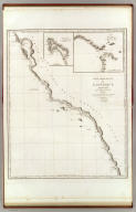
Vancouver, George, 1757-1798
Full Title
A Chart shewing part of the Coast of N.W. America, With the Tracks of His Majesty's Sloop Discovery and Armed Tender Chatham; Commanded by George Vancouver Esqr. and prepared under his immediate inspection by Lieut. Joseph Baker, in which the Continental Shore has been traced and determined from Lat. 30¼00'N. and Long. 244¼32' E. to Lat. 38¼30'N and Long 237¼13'E. Engraved by T. Foot, Weston Place, Battle Bridge. No. 8. (with) Entrance of Port Sn. Francisco. (and) Port Sn. Diego. London: Published May 1st 1798, by J. Edwards Pall Mall & G. Robinson Paternoster Row.
List No
3354.008
Note
Map uncolored and shaded. Note in the title cartouche states, "The parts shaded Red are taken from Spanish Authorities." (No red shading has been added to this copy.) The vessels' tracks are shown by dotted lines. Spanish Missions and Presidios are noted. Map extends from St. Domingo, Mexico in the south to Point Reyes, California in the north.
Author
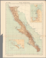
Vandermaelen, Philippe, 1795-1869
Full Title
Nouvelle Californie. Amer. Sep. no. 46. (with profile) Includes profile: Tableau physique de la pente Occidentale du Plateau de la nouvelle Espagne. Chemin de Mexico a Acapulco, d'apres A. de Humboldt. Dressee et dessinee par Ph. Vandermaelen. Desee. sur pierre et Lith. par H. Ode, juillet 1825.
List No
10068.000
Note
This is a variant edition - see our 2212.251. Hand col. lithographed map. Relief shown by hachures. Shows Indian tribes, Vancouver's route, etc. Covers parts of southern Nevada, Southern California, Arizona, Baja California Norte and Sonora. Includes text: Vielle Californie.
Author
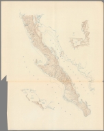
Vandermaelen, Philippe, 1795-1869
Full Title
Partie de la Vielle Californie. Amer. Sep. no. 53. Dressee et dessinee par Ph. Vandermaelen. Lith par H. Ode. Aout 1824. (Quatrieme partie. - Amer. sept. Bruxelles. 1827)
List No
2212.258
Note
Hand col. lithographed map. Relief shown by hachures. Shows Indian tribes, Vancouver's route, etc. Covers parts of southern Nevada, Southern California, Arizona, Baja California Norte and Sonora. Includes text: Vielle Californie.
Author
Vancouver, George, 1757-1798
Full Title
Cote nord-ouest de l'Amerique. Reconnue par le Cape. Vancouver. 1e. partie, depuis 3000' de latitude septle. et 244032' de longitude jusqu'a 38030' de late. et 237013' de longe. (with) Port St. Diego. (with) Entree de Port St. Francisco. Voyage de Vancouver. No. 4. (Paris: Depot-general de la Marine, 1828)
List No
0233.005
Note
Engraved map. Relief shown pictorially; depths by soundings. Covers the coast from Bodega Bay, California to El Rosario, Baja California. Shows vessels' tracks. Inset maps show relief by hachures; depths by soundings.
Author
[Johnston, Alexander Keith, 1804-1871, Rogers, Henry Darwin]
Full Title
Mexico, North-western States. By Prof. H.D. Rogers & A. Keith Johnston, F.R.S.E. Entered in Sta. Hall. London ... & according to an act of Congress ... 1857, by H.D. Rogers ... Massachusetts. London, John Murray, Albemarle Street, Edinburgh, W. & A.K. Johnston. Engraved by W. & A.K. Johnston, Edinburgh.
List No
3825.020
Note
Baja California and the Northwestern part of Mexico shown in pink outline color.
Author
Garcia Cubas, Antonio, 1832-1912
Full Title
Baja California. Imp. litog. de H. Iriarte, ce. de Sta Clara no. 23. Munozguren lito. Imprenta de J.M. Lara. Entrega 4a. (1858)
List No
4116.025
Note
Lithographed map. State boundaries hand col. Relief shown by hachures. Text and tables surround map. "Atlas mexicano, por Antonio Garcia y Cubas Carta XXV." Prime meridian: Mexico, D.F.
Author
Freyhold, Edward; Warren, Gouverneur Kemble, 1830-1882; United States. Army. Corps of Engineers
Full Title
Map of the Territory of the U.S. West of the Miss. Riv. Sheet no. 4. (Prepared by authority of the Hon. the Secretary of War in the Office of the Chief of Engineers under the direction of Brig. General A.A. Humphreys Chief of Engineers and Brevet Maj. Gen. U.S. Army. By Edward Freyhold 1879) (with) Territory of Alaska.
List No
3359.004
Note
Hand col. lithographed map. Relief shown by hachures and spot heights. Covers also part of Baja California. Alaska inset at scale (ca. 1:9,000,000).
Author
Garcia Cubas, Antonio, 1832-1912
Full Title
(Title Page to) Atlas geografico y estadistico de los Estados Unidos Mexicanos por Antonio Garcia Cubas. Publicado por Debray Sucesores, Portal del Coliseo Viejo num. 6. Mexico. (1886)
List No
5758B
Note
In red and black. "Obra compuesta de una magnifica Carta General con expresion de las lineas de ferrocarriles y telegrafos, y de 30 cartas de los estados, Distrito Federal, territorios de la Baja California y Tepic, con sus correspondientes textos en espanol, frances e ingles." "The text accompanying the maps is printed in Spanish, French and English, and gives, besides general information, a detailed topographical description of every state"--Phillips 2687. Covers: half leather, red cloth and stamped in gilt "Atlas mexicano, geografico, estadistico por A. Garcia Cubas."
Author
[Powell, John Wesley, 1834-1902, United States Geological Survey (USGS), Gannett, Henry, 1846-1914, King, Harry]
Full Title
(Map of the United States. Compiled under the director of Henry Gannett, Chief Topographer, by Harry King, Chief Draughtsman. Department of the Interior, United States Geological Survey, J. W. Powell, Director. 1890. Edition of April 1891. Engraved by Julius Bien & Co. New York. Sheet 7).
List No
14054.008
Note
Sheet 7 of USGS topographic map of the United States, backed with linen and bound with corresponding sheets. This sheet includes part of the southern international border, with Arizona and New Mexico, as well as northwestern Mexico and Baja California. Conveys topography with contour lines, which include elevation figures. Shows state boundaries, cities and towns, railroads, drainage, and national parks, as well as Native American territories and reservations. 40 x 64 cm, on sheet 47 x 69 cm. With inset: Alaska. (Title taken from Sheet 9.)
Author
Mexico. Direccion de Estudios Geográficos y Climatologicos
Full Title
Baja California. Secretaria de Agricultura y Fomento : Direccion de Estadios Geograficos y Climatologicos ... Mexico. 2a. Edicion, 1922. ( to accompany) Atlas geografico de la Republica Mexicana 1919-1921. (on upper margin) No. 3. (insets) Poerto y Alrededores de la Paz ; Bahia de la Magdalena y sus Alrededores.
List No
10559.013
Note
Color map with 2 insets. Shows areas of population density, roads, major cities, ports, etc. Relief shown by shadings. Depth shown by isolines and soundings.
Author
Mexico. Direccion de Estudios Geográficos y Climatologicos
Full Title
(Relief map of Baja California). ( to accompany) Atlas geografico de la Republica Mexicana 1919-1921.
List No
10559.014
Note
Untitled color relief map. Shows mountains and rivers. Relief shown by shadings. Depth shown by isolines and soundings. Title supplied by cataloger.
Author
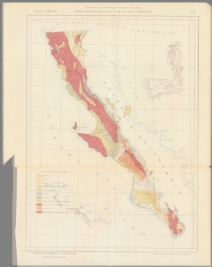
Mexico. Direccion de Estudios Geográficos y Climatologicos
Full Title
Bosquejo Geologico Del E. De Baja California. Secretaria de Agricultura y Fomento : Direccion de Estadios Geograficos y Climatologicos ... Mexico. 2a. Edicion, 1922. ( to accompany) Atlas geografico de la Republica Mexicana 1919-1921. (on upper margin) No. 2.
List No
10559.015
Note
Geological map.
Author
Mexico. Direccion de Estudios Geográficos y Climatologicos
Full Title
Composite: Bosquejo Geologico Del E. De Baja California and Relief Map Overlaid.
List No
10559.016
Note
Geological map.
Author
Mexico. Direccion de Estudios Geográficos y Climatologicos
Full Title
Baja California. Secretaria de Agricultura y Fomento : Direccion de Estadios Geograficos y Climatologicos ... Mexico. 2a. Edicion, 1922. ( to accompany) Atlas geografico de la Republica Mexicana 1919-1921. (on upper margin) No. 3. (insets) Poerto y Alrededores de la Paz ; Bahia de la Magdalena y sus Alrededores.
List No
6735.009
Note
Thirty-two numbered maps, most followed by a relief map and a geologic map. Full color. Some maps, 2nd edition. Maps were also issued separately. Cover - title page shows full color view of Southwestern Coast of North America, with decorative Mayan illustration on the background, and a Maya Indian drawing map. Seccion de cartografia: Jefe: Ing. Sotero Prieto. Jefe Ing. Luciano Lopez Sorcini. Zincografos: Antonio Hernandez , et al. Seccion de calculos: Jefe. Ing. Ricardo Toscano.
Author
Mexico. Direccion de Estudios Geográficos y Climatologicos
Full Title
(Relief map of Baja California). ( to accompany) Atlas geografico de la Republica Mexicana 1919-1921.
List No
6735.010
Note
Thirty-two numbered maps, most followed by a relief map and a geologic map. Full color. Some maps, 2nd edition. Maps were also issued separately. Cover - title page shows full color view of Southwestern Coast of North America, with decorative Mayan illustration on the background, and a Maya Indian drawing map. Seccion de cartografia: Jefe: Ing. Sotero Prieto. Jefe Ing. Luciano Lopez Sorcini. Zincografos: Antonio Hernandez , et al. Seccion de calculos: Jefe. Ing. Ricardo Toscano.
Author
[Gutiérrez, Tonatiúh, 1929-, Mexico. Secretaría de Industria y Comercio, Mexico. Comisión Nacional Consultiva de Pesca, Instituto Nacional de Investigaciones Biológico Pesqueras (Mexico), Mexico. Dirección General de Pesca e Industrias Conexas]
Full Title
Registro de la explotacion nacional por entidades. Atlas pesquero nacional, 1965, Tonatiúh Gutiérrez. Lámina No. 9.
List No
14303.025
Note
Colored chart of Mexico representing the fishing economy, by region, from 1950 to 1964. Title translates to: Registry of national exploitation by regions. Chart is 21 x 30, on sheet 24 x 34 cm; atlas opened to double page 24 x 68 cm. Accompanied by a collage of black and white photographs showing fish processing on preceding plate. Facing page - interleaved between chart and collage - contains accompanying descriptive text on transparent paper, through which one can see a partial view of the collage. Text begins: El estado de Baja California Norte, desde el año de 1955, es el que ha venido explotando los mayores volúmenes de productos pesqueros del país ... [= The state of Baja California Norte, since 1955, is the one that has been exploiting the largest volumes of fishery products in the country ... ].
1-17 of 17
|