|
Author
Le Rouge, Georges-Louis, 1712-1790
Full Title
Attaques de Berg-op-Zoom : Commencees du 14 au 15 juillet 1747. A Paris, Chez le Sr. le Rouge ... (to accompany) Recueil contenant des cartes nouvelles ... A Paris, Par et chez le Sr. le Rouge 1742. (inset) Environs de Berg op zoom.
List No
11793.023
Note
Hand colored map of the Siege of Bergen op Zoom. Showing fortifications, canals, rivers and buildings and landmarks. Includes index to important places and notes.
Author
Le Rouge, Georges-Louis, 1712-1790
Full Title
2e Plan de la bataille de Laveld. Gagnee par le Roy le 2 Juillet 1747. A Paris, Chez le Sr. Le Rouge ... (to accompany) Recueil contenant des cartes nouvelles ... A Paris, Par et chez le Sr. le Rouge 1742.
List No
11793.044
Note
Hand colored plan of the Battle of Lawfeld. Showing the fortification, canals, rivers, forests and buildings. Positions troops shown in color. Includes legend and alphabetical and numerical references. Relief shown by hachures.
Author
[Rocque, John, Parr, Richard]
Full Title
(title page to) An exact survey of the cities of London and Westminster, the borough of Southwark, with the country near ten miles round ; begun in 1741, finished in 1745, and publish'd in 1746, according to act of Parliament...Urbium maxime insignium Londini et Westmonasterii nec non municipii Sudovercencis...Carte topographique des villes de Londres, Westminster, et bourg de Southwark
List No
10258.001
Author
[Rocque, John, Parr, Richard]
Full Title
(Text page to) A List of Subscribers of the Work.
List No
10258.002
Author
[Rocque, John, Parr, Richard]
Full Title
(Index page to) Index of the Towns, Villages &c. compiled within this Survey.
List No
10258.003
Author
[Rocque, John, Parr, Richard]
Full Title
Sheet I An Exact Survey of the City's of London and Westminster ye Borough of Southwark and the Country Near Ten Miles Round Begun in 1741 & Ending in 1745 by John Rocque Land Surveyor & Engrav'd by Richard Parr
List No
10258.004
Note
Dated February 13, 1744
Author
[Rocque, John, Parr, Richard]
Full Title
Sheet II An Exact Survey of the City's of London and Westminster ye Borough of Southwark and the Country Near Ten Miles Round Begun in 1741 & Ending in 1745 by John Rocque Land Surveyor & Engrav'd by Richard Parr
List No
10258.005
Author
[Rocque, John, Parr, Richard]
Full Title
Sheet III An Exact Survey of the City's of London and Westminster ye Borough of Southwark and the Country Near Ten Miles Round Begun in 1741 & Ending in 1745 by John Rocque Land Surveyor & Engrav'd by Richard Parr
List No
10258.006
Author
[Rocque, John, Parr, Richard]
Full Title
Sheet IV An Exact Survey of the City's of London and Westminster ye Borough of Southwark and the Country Near Ten Miles Round Begun in 1741 & Ending in 1745 by John Rocque Land Surveyor & Engrav'd by Richard Parr
List No
10258.007
Author
[Rocque, John, Parr, Richard]
Full Title
Sheet V An Exact Survey of the City's of London and Westminster ye Borough of Southwark and the Country Near Ten Miles Round Begun in 1741 & Ending in 1745 by John Rocque Land Surveyor & Engrav'd by Richard Parr
List No
10258.008
Author
[Rocque, John, Parr, Richard]
Full Title
Sheet VI An Exact Survey of the City's of London and Westminster ye Borough of Southwark and the Country Near Ten Miles Round Begun in 1741 & Ending in 1745 by John Rocque Land Surveyor & Engrav'd by Richard Parr
List No
10258.009
Note
Dated April 29, 1746
Author
[Rocque, John, Parr, Richard]
Full Title
Sheet VII An Exact Survey of the City's of London and Westminster ye Borough of Southwark and the Country Near Ten Miles Round Begun in 1741 & Ending in 1745 by John Rocque Land Surveyor & Engrav'd by Richard Parr
List No
10258.010
Author
[Rocque, John, Parr, Richard]
Full Title
Sheet VIII An Exact Survey of the City's of London and Westminster ye Borough of Southwark and the Country Near Ten Miles Round Begun in 1741 & Ending in 1745 by John Rocque Land Surveyor & Engrav'd by Richard Parr
List No
10258.011
Author
[Rocque, John, Parr, Richard]
Full Title
Sheet IX An Exact Survey of the City's of London and Westminster ye Borough of Southwark and the Country Near Ten Miles Round Begun in 1741 & Ending in 1745 by John Rocque Land Surveyor & Engrav'd by Richard Parr
List No
10258.012
Author
[Rocque, John, Parr, Richard]
Full Title
Sheet X An Exact Survey of the City's of London and Westminster ye Borough of Southwark and the Country Near Ten Miles Round Begun in 1741 & Ending in 1745 by John Rocque Land Surveyor & Engrav'd by Richard Parr
List No
10258.013
Author
[Rocque, John, Parr, Richard]
Full Title
Sheet XI An Exact Survey of the City's of London and Westminster ye Borough of Southwark and the Country Near Ten Miles Round Begun in 1741 & Ending in 1745 by John Rocque Land Surveyor & Engrav'd by Richard Parr
List No
10258.014
Author
[Rocque, John, Parr, Richard]
Full Title
Sheet XII An Exact Survey of the City's of London and Westminster ye Borough of Southwark and the Country Near Ten Miles Round Begun in 1741 & Ending in 1745 by John Rocque Land Surveyor & Engrav'd by Richard Parr
List No
10258.015
Author
[Rocque, John, Parr, Richard]
Full Title
Sheet XIII An Exact Survey of the City's of London and Westminster ye Borough of Southwark and the Country Near Ten Miles Round Begun in 1741 & Ending in 1745 by John Rocque Land Surveyor & Engrav'd by Richard Parr
List No
10258.016
Note
Dated December 28, 1744
Author
[Rocque, John, Parr, Richard]
Full Title
Sheet XIV An Exact Survey of the City's of London and Westminster ye Borough of Southwark and the Country Near Ten Miles Round Begun in 1741 & Ending in 1745 by John Rocque Land Surveyor & Engrav'd by Richard Parr
List No
10258.017
Author
[Rocque, John, Parr, Richard]
Full Title
Sheet XV An Exact Survey of the City's of London and Westminster ye Borough of Southwark and the Country Near Ten Miles Round Begun in 1741 & Ending in 1745 by John Rocque Land Surveyor & Engrav'd by Richard Parr
List No
10258.018
Author
[Rocque, John, Parr, Richard]
Full Title
Sheet XVI An Exact Survey of the City's of London and Westminster ye Borough of Southwark and the Country Near Ten Miles Round Begun in 1741 & Ending in 1745 by John Rocque Land Surveyor & Engrav'd by Richard Parr
List No
10258.019
Author
[Rocque, John, Parr, Richard]
Full Title
(Composite map to) Sheets I-XVI An Exact Survey of the City's of London and Westminster ye Borough of Southwark and the Country Near Ten Miles Round Begun in 1741 & Ending in 1745 by John Rocque Land Surveyor & Engrav'd by Richard Parr
List No
10258.020
Author
Bowen, Emanuel
Full Title
(Title Page to) A complete system of geography. Being a description of all the countries, islands, cities, chief towns, harbours, lakes, and rivers, mountains, mines, &c. of the known world ... In two volumes. The whole illustrated with seventy maps, by Emanuel Bowen, Geographer to His Majesty, being all new-drawn and ingraved according to the latest discoveries and surveys; making, of themselves, a complete atlas, for the sse of gentlemen, merchants, mariners, and others, who delight in history and geography ... Vol. 1. London: Printed for William Innys, Richard Ware, Aaron Ward, J. and P. Knapton, John Clarke, T. Longman and T. Shewell, Thomas Osborne, Henry Whitridge ... M.DCC.XLVII.
List No
3733A
Note
In the title Bowen states that he is "Preserving all that is useful in the Fourth and Last edition of the Complete Geographer, publish'd under the name of Herman Moll, &c." The 70 maps were also published in two other forms: in "A Complete Atlas" of 1752, and as the Maps for the "Complete Collection of Voyages" by John Harris, in 1744-48 (M&B). The text is massive and interesting, and there are several important maps of America: America, West Indies, Mexico, Louisiana, Carolina, Virginia, Pennsylvania et al, and Newfoundland et al. The map of the World in Hemispheres is lacking in this copy. Both volumes are newly bound in full brown leather covered boards with "Geography. Vol. 1" and -Geography. Vol. 2" embossed on the spine in gilt.
Author
Bowen, Emanuel
Full Title
(Index to) A complete system of geography. Being a description of all the countries, islands, cities, chief towns, harbours, lakes, and rivers, mountains, mines, &c. of the known world ... In two volumes. The whole illustrated with seventy maps, by Emanuel Bowen, Geographer to His Majesty, being all new-drawn and ingraved according to the latest discoveries and surveys; making, of themselves, a complete atlas, for the sse of gentlemen, merchants, mariners, and others, who delight in history and geography ... Vol. 1. London: Printed for William Innys, Richard Ware, Aaron Ward, J. and P. Knapton, John Clarke, T. Longman and T. Shewell, Thomas Osborne, Henry Whitridge ... M.DCC.XLVII.
List No
3733B
Note
"A list of the maps and plages with directions for placing them." In the title Bowen states that he is "Preserving all that is useful in the Fourth and Last edition of the Complete Geographer, publish'd under the name of Herman Moll, &c." The 70 maps were also published in two other forms: in "A Complete Atlas" of 1752, and as the Maps for the "Complete Collection of Voyages" by John Harris, in 1744-48 (M&B). The text is massive and interesting, and there are several important maps of America: America, West Indies, Mexico, Louisiana, Carolina, Virginia, Pennsylvania et al, and Newfoundland et al. The map of the World in Hemispheres is lacking in this copy. Both volumes are newly bound in full brown leather covered boards with "Geography. Vol. 1" and -Geography. Vol. 2" embossed on the spine in gilt.
Author
Bowen, Emanuel
Full Title
The Solar System, with the orbits of 5 remarkable comets. (By Emanuel Bowen. London: Printed for William Innys, Richard Ware, Aaron Ward, J. and P. Knapton, John Clarke, T. Longman and T. Shewell, Thomas Osborne, Henry Whitridge ... M.DCC.XLVII)
List No
3733.001
Note
Engraved map. Includes three figures: Oblique sphere -- Right sphere -- Parallel sphere.
Author
Bowen, Emanuel
Full Title
A circle of winds consisting of 32 points commonly called the mariners compass. The artificial sphere. (By Emanuel Bowen. London: Printed for William Innys, Richard Ware, Aaron Ward, J. and P. Knapton, John Clarke, T. Longman and T. Shewell, Thomas Osborne, Henry Whitridge ... M.DCC.XLVII)
List No
3733.002
Note
Two engraved drawings within border. Includes view of ships and cherubs with navigational instruments.
Author
Bowen, Emanuel
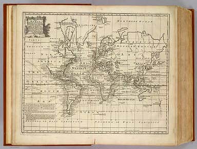
Full Title
A New & Accurate Map of all the Known World Drawn from the latest & most Authentic Surveys
List No
3733.071
Note
This map added to the atlas which was missing the original.
Author
Bowen, Emanuel
Full Title
A new & accurate chart of the world. Drawn from authentic surveys, assisted by the most approved modern maps & charts & regulated by astronl. observations, whereon are described lines, shewing the variation of the magnetical needle, according to observations made by several experienced navigators about the year 1744. By Eman: Bowen, Geographer to His Majesty. (London: Printed for William Innys, Richard Ware, Aaron Ward, J. and P. Knapton, John Clarke, T. Longman and T. Shewell, Thomas Osborne, Henry Whitridge ... M.DCC.XLVII)
List No
3733.003
Note
Engraved map. Includes note on lines of magnetic declination, and dates of European discoveries.
Author
Bowen, Emanuel
Full Title
A new and accurate map of Europe. Collected from the best authorities, assisted by the most approv'd modern maps & charts. The whole being regulated & adjusted by astronl. observations, by Emanl. Bowen. (London: Printed for William Innys, Richard Ware, Aaron Ward, J. and P. Knapton, John Clarke, T. Longman and T. Shewell, Thomas Osborne, Henry Whitridge ... M.DCC.XLVII)
List No
3733.004
Note
Engraved map with ornamental cartouche. Relief shown pictorially.
Author
Bowen, Emanuel
Full Title
A new and accurate map of Great Britain & Ireland, together with their respective islands &c. Drawn from surveys and the most approved maps and charts. The whole being regulated by astronomical observations, by Emanl. Bowen. (London: Printed for William Innys, Richard Ware, Aaron Ward, J. and P. Knapton, John Clarke, T. Longman and T. Shewell, Thomas Osborne, Henry Whitridge ... M.DCC.XLVII)
List No
3733.005
Note
Engraved map. Has ornamental cartouche with two views. Relief shown pictorially.
Author
Bowen, Emanuel
Full Title
A new and very accurate map of South Britain, or England and Wales. Drawn from a great number of particular surveys, assisted by some of the most approved maps & charts. Containing all the cities, boroughs, market towns &c. With the principal direct & cross roads, also exhibiting the distances between the towns situated upon each road; together with the post stages &c. The whole being regulated by astronomical observatns. By Eman. Bowen. (London: Printed for William Innys, Richard Ware, Aaron Ward, J. and P. Knapton, John Clarke, T. Longman and T. Shewell, Thomas Osborne, Henry Whitridge ... M.DCC.XLVII)
List No
3733.006
Note
Engraved map. Shows forested areas, etc. Relief shown pictorially. Includes note on compilation of map.
Author
Bowen, Emanuel
Full Title
A new & accurate map of Scotland or North Britain. Drawn from surveys and most approved maps and charts, & regulated by astronl. observns. With several imrovemts. not to be found in any other map extant. By Eman. Bowen. (London: Printed for William Innys, Richard Ware, Aaron Ward, J. and P. Knapton, John Clarke, T. Longman and T. Shewell, Thomas Osborne, Henry Whitridge ... M.DCC.XLVII)
List No
3733.007
Note
Engraved map. Shows forested areas, banks, etc. Relief shown pictorially. Includes inset map of the Shetland Islands, tables of the shires and parliamentary boroughs, and cartographic notes.
Author
Bowen, Emanuel
Full Title
A new and accurate map of Ireland. Laid down from the best authorities extant, and regulated by astronoml. observatns. By Emanl. Bowen. (London: Printed for William Innys, Richard Ware, Aaron Ward, J. and P. Knapton, John Clarke, T. Longman and T. Shewell, Thomas Osborne, Henry Whitridge ... M.DCC.XLVII)
List No
3733.008
Note
Engraved map. Shows forested areas, banks, etc. Relief shown pictorially. Includes geographic notes.
Author
Bowen, Emanuel
Full Title
A new and accurate map of France with its aquisitions, composed from the latest surveys, assisted by the most approved modern maps & charts, & regulated by astronl. observatns. By Emanl. Bowen. (London: Printed for William Innys, Richard Ware, Aaron Ward, J. and P. Knapton, John Clarke, T. Longman and T. Shewell, Thomas Osborne, Henry Whitridge ... M.DCC.XLVII)
List No
3733.009
Note
Engraved map. Shows forested areas, etc. Relief shown pictorially. Inset maps: The city and port of Toulon -- The harbour of Brest. Includes geographic notes and ornamental cartouche.
Author
Bowen, Emanuel
Full Title
A new & accurate map of Spain and Portugal. Drawn from surveys assisted by ye. most approved modern maps and charts. The whole being regulated by astronomical observations. By Eman. Bowen. (London: Printed for William Innys, Richard Ware, Aaron Ward, J. and P. Knapton, John Clarke, T. Longman and T. Shewell, Thomas Osborne, Henry Whitridge ... M.DCC.XLVII)
List No
3733.010
Note
Engraved map. Shows forested areas, etc. Relief shown pictorially. Inset maps: The harbour of Port Mahon -- A chart of the Straits of Gibralter with the coast of Spain from Cadiz to Malaga. Includes geographic notes and ornamental cartouche.
Author
Bowen, Emanuel
Full Title
A new and accurate map of Portugal. Composed from the latest improvemts. and adjusted by the most authentic astronl. observats. By Eman: Bowen. (London: Printed for William Innys, Richard Ware, Aaron Ward, J. and P. Knapton, John Clarke, T. Longman and T. Shewell, Thomas Osborne, Henry Whitridge ... M.DCC.XLVII)
List No
3733.011
Note
Engraved map. Shows forested areas, etc. Relief shown pictorially. Includes geographic note and ornamental cartouche.
Author
Bowen, Emanuel
Full Title
A new & accurate map of the Netherlands or Low Countries. Laid down from the best authorities, assisted by the most approved modern maps and regulated by astronl. observations. By Eman. Bowen. (London: Printed for William Innys, Richard Ware, Aaron Ward, J. and P. Knapton, John Clarke, T. Longman and T. Shewell, Thomas Osborne, Henry Whitridge ... M.DCC.XLVII)
List No
3733.012
Note
Engraved map. Shows forested areas, etc. Relief shown pictorially. Includes note on the Barrier Treaty, and ornamental cartouche. Covers also French Flanders and parts of Artois.
Author
Bowen, Emanuel
Full Title
A new and accurate map of the Seven United Provinces. Compiled from the most approv'd maps & charts and adjusted by astronoml. observations. By Emanl. Bowen. (London: Printed for William Innys, Richard Ware, Aaron Ward, J. and P. Knapton, John Clarke, T. Longman and T. Shewell, Thomas Osborne, Henry Whitridge ... M.DCC.XLVII)
List No
3733.013
Note
Engraved map. Shows forested areas, marshes, banks, etc. Relief shown pictorially. Includes map "A chart of the sea coast of England, Holland, Zeeland and Flanders, shewing the sands, soundings, bearings &c. According to Cn. Collins, also describing some of the usual tracks of sailing from one shore to the other." Includes cartographic note and ornamental cartouche.
Author
Bowen, Emanuel
Full Title
A new & accurate map of Germany, divided into its circles & drawn from the most approv'd maps &c. and regulated by astronoml. observatns. By Emanl. Bowen. (London: Printed for William Innys, Richard Ware, Aaron Ward, J. and P. Knapton, John Clarke, T. Longman and T. Shewell, Thomas Osborne, Henry Whitridge ... M.DCC.XLVII)
List No
3733.014
Note
Engraved map. Covers Switzerland, Austria, Bohemia, the Low Countries, northern Italy and surrounding areas. Shows forested areas, etc. Relief shown pictorially. Includes cartographic note and ornamental cartouche.
Author
Bowen, Emanuel
Full Title
A new & accurate map of the South West part of Germany. Comprehending the Archbishopricks of Mentz and Treves; the Electoral Palat: of the Rhine; Duchy of Wirtemberg; Franconia, Swabia, Alsace, Lorrain &c. Drawn from the best authorities and most approved maps and regulated by astronl. observations. By Emanl. Bowen. (London: Printed for William Innys, Richard Ware, Aaron Ward, J. and P. Knapton, John Clarke, T. Longman and T. Shewell, Thomas Osborne, Henry Whitridge ... M.DCC.XLVII)
List No
3733.015
Note
Engraved map. Covers also Luxembourg. Shows forested areas. Relief shown pictorially. Includes cartographic note and ornamental cartouche. Includes 2 inset maps entitled, "Exact plans of old and new Brisac or Brisach with their fortifications and places adjacent."
Author
Bowen, Emanuel
Full Title
A new & accurate map of the South East part of Germany, containing the Electorate of Bavaria, A.Bp. of Saltzburg, K. of Bohemia, with the Queen of Hungary's hereditary dominions of Austria, Moravia, Styria, Carinthia, Carniola, Trent, Tirol. &c. Drawn from the best authorities & most approv'd maps, & regulated by astronomical observations. By Emanl. Bowen. (London: Printed for William Innys, Richard Ware, Aaron Ward, J. and P. Knapton, John Clarke, T. Longman and T. Shewell, Thomas Osborne, Henry Whitridge ... M.DCC.XLVII)
List No
3733.016
Note
Engraved map. Shows forested areas. Relief shown pictorially. Includes ornamental cartouche.
Author
Bowen, Emanuel
Full Title
A new & accurate map of the North East part of Germany, containing the dominions of the Electors of Saxony & Brandenburg with Silesia, ceded to the K. of Prussia by the Treaty of Breslaw. Also the Duchys of Mecklenburg, Pomerania &c. Laid down from the best authorities & most approv'd maps, & adjusted by astronomical observations. By Emanl. Bowen. (London: Printed for William Innys, Richard Ware, Aaron Ward, J. and P. Knapton, John Clarke, T. Longman and T. Shewell, Thomas Osborne, Henry Whitridge ... M.DCC.XLVII)
List No
3733.017
Note
Engraved map. Shows forested areas. Relief shown pictorially. Includes ornamental cartouche. Inset map: A plan of the City of Breslaw, capital of Silesia.
Author
Bowen, Emanuel
Full Title
A new & accurate map of the North West part of Germany, containing Westphalia & Lowr. Saxony, wherein are included ye. domins. of ye. Electors of Brunswick Lunenburg or Hannover Cologne &c., Landgrave of Hesse, Duchys of Holstein, Juliers &c., with the Bishopricks of Munster, Osnabrug &c. Laid down from the best authorities and regulated by astronomical observations. By Emanl. Bowen. (London: Printed for William Innys, Richard Ware, Aaron Ward, J. and P. Knapton, John Clarke, T. Longman and T. Shewell, Thomas Osborne, Henry Whitridge ... M.DCC.XLVII)
List No
3733.018
Note
Engraved map. Shows forested areas. Relief shown pictorially. Includes ornamental cartouche.
Author
Bowen, Emanuel
Full Title
A new & accurate map of Switzerland with its allies and subjects. Composed from ye. most approv'd maps &c. and regulated by astronoml. observatns. By Emanl. Bowen. (London: Printed for William Innys, Richard Ware, Aaron Ward, J. and P. Knapton, John Clarke, T. Longman and T. Shewell, Thomas Osborne, Henry Whitridge ... M.DCC.XLVII)
List No
3733.019
Note
Engraved map. Relief shown pictorially. Inset map: A new plan of the City of Geneva. (Scale ca. 1:27,500)
Author
Bowen, Emanuel
Full Title
A new and accurate map of Savoy, Piemont, and Montferrat. Exhibiting the present seat of war. Collected from the best authorities and most approved modern maps. The whole being regulated by astronl. observations. By Eman. Bowen. (London: Printed for William Innys, Richard Ware, Aaron Ward, J. and P. Knapton, John Clarke, T. Longman and T. Shewell, Thomas Osborne, Henry Whitridge ... M.DCC.XLVII)
List No
3733.020
Note
Engraved map. Relief shown pictorially. Inset maps: A draught of the City of Nice and Town of Villa Franca, with some part of the adjacent coast -- A plan of Coni, a strong fortified city, situated on a hill between two rivers, which renders its approach on the east and west sides very difficult. (Scale 1:12,000)
Author
Bowen, Emanuel
Full Title
A new and accurate map of Italy. Drawn from the latest and best authorities, and regulated by the most approved astronl. observations. By Eman. Bowen. (London: Printed for William Innys, Richard Ware, Aaron Ward, J. and P. Knapton, John Clarke, T. Longman and T. Shewell, Thomas Osborne, Henry Whitridge ... M.DCC.XLVII)
List No
3733.021
Note
Engraved map. Relief shown pictorially. Covers also Corsica. Includes geographic notes and ornamental cartouche. Inset views: A draught of the Eruptions of Mt. Aetna in 1669 &c. -- Mt. Vesuvius two leagues from Naples.
Author
Bowen, Emanuel
Full Title
A new and accurate map of the northern parts of Italy. Comprehending Savoy, Piemont, Milan, Parma, Mantua, Modena, Tuscany, with the Republicks of Venice, Genoa and Lucca. Drawn from the latest & best authorities & regulated by astronl. obserns. By Emanl. Bowen. (London: Printed for William Innys, Richard Ware, Aaron Ward, J. and P. Knapton, John Clarke, T. Longman and T. Shewell, Thomas Osborne, Henry Whitridge ... M.DCC.XLVII)
List No
3733.022
Note
Engraved map. Shows forested areas. Relief shown pictorially. Inset map: A draught of the Road of Leghorn. "This draught is copy'd after that drawn by the Order of the C: de Maurepas."
Author
Bowen, Emanuel
Full Title
A new & accurate map of the Kingdoms of Naples & Sicily. Drawn from the most approv'd foreign maps & charts, and regulated by astronl. observations. By Emanl. Bowen. (London: Printed for William Innys, Richard Ware, Aaron Ward, J. and P. Knapton, John Clarke, T. Longman and T. Shewell, Thomas Osborne, Henry Whitridge ... M.DCC.XLVII)
List No
3733.023
Note
Engraved map. Shows forested areas. Relief shown pictorially. Includes ornamental cartouche.
Author
Bowen, Emanuel
Full Title
A new and accurate map of Scandinavia, or the northern crowns of Sweden, Denmark, and Norway, drawn from the most approv'd maps and charts and adjusted by astronoml. observations. By Emanl. Bowen. (London: Printed for William Innys, Richard Ware, Aaron Ward, J. and P. Knapton, John Clarke, T. Longman and T. Shewell, Thomas Osborne, Henry Whitridge ... M.DCC.XLVII)
List No
3733.024
Note
Engraved map. Relief shown pictorially. Includes ornamental cartouche. Covers also Finland and parts of Russia. Inset map: A map of Spitzbergen or Greenland, Iceland, and some part of Groenland &c.
Author
Bowen, Emanuel
Full Title
A new and accurate map of Denmark. Drawn from the best authorities & most approved maps: the whole being regulated by astronl. observations. By Emanl. Bowen. (London: Printed for William Innys, Richard Ware, Aaron Ward, J. and P. Knapton, John Clarke, T. Longman and T. Shewell, Thomas Osborne, Henry Whitridge ... M.DCC.XLVII)
List No
3733.025
Note
Engraved map. Shows forested areas. Relief shown pictorially. Includes geographical note and ornamental cartouche.
|